Follow the Rhine downstream and its name changes, its channel crosses or follows national borders, and eventually the river divides. A map that ends with one arrow at Rotterdam misses an important part of the story: the Rhine reaches the sea through a connected delta, not one simple mouth.
The Rhine runs from the Swiss Alps to the North Sea through a river system about 766 miles (1,233 km) long. Its course passes through or along Switzerland, Liechtenstein, Austria, Germany, France and the Netherlands. Downstream, the Waal, Nederrijn–Lek and IJssel connect it to different parts of the Dutch delta.
How to use this guide: Start with the map, distinguish river countries from basin countries, and use the branching diagram to understand the river’s outlets.
1. Follow the Rhine on the map
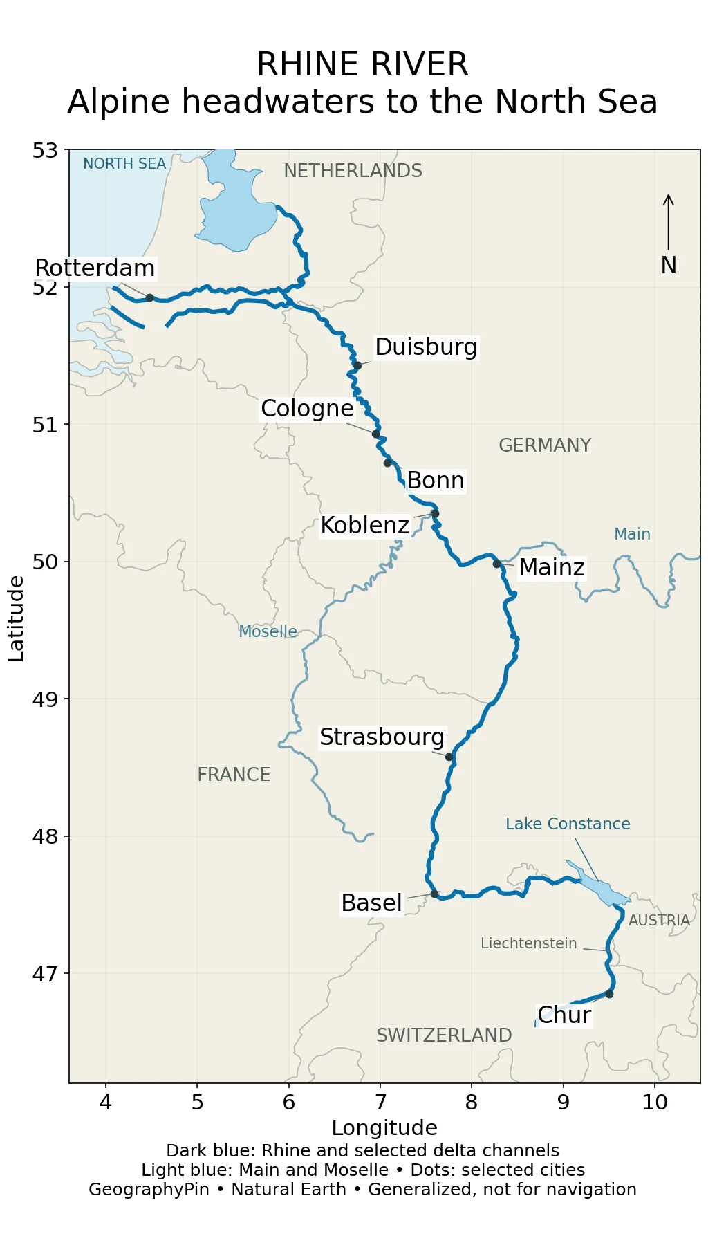
The broad sequence is alpine headwaters, Lake Constance, a westward reach to Basel, a northward course through the Upper and Middle Rhine, and the lower river toward the Netherlands. The river therefore does not flow north at every point. “Downstream” means toward its outlets, not toward the top or bottom of a page.
Use the cities as orientation anchors: Basel marks a major turn, Mainz lies near the transition toward the Rhine’s gorge country, and Cologne and Duisburg help locate the lower German reach. Rotterdam belongs to the downstream delta network rather than to a single unbranched channel still called Rhine.
The map deliberately leaves out many tributaries and small channels. In particular, a missing tributary does not mean the river has no connection to that catchment. For the distinction between a main stem, tributary and drainage basin, see our guide to the parts of a river.
2. Where the Rhine begins and how long it is
The Rhine’s alpine headwater system includes the Vorderrhein and Hinterrhein. They meet near Reichenau in Switzerland, after which the river is called the Alpine Rhine. The International Commission for the Protection of the Rhine (ICPR) identifies Lake Toma, also called Tomasee, with the Vorderrhein’s source. This named source is not the origin of every drop of Rhine water: tributaries, rainfall runoff, snowmelt and groundwater contribute along the system.
The Alpine Rhine enters Lake Constance. The lake system includes the Obersee and Untersee, connected through the Seerhein at Konstanz. Downstream of the Untersee, the High Rhine runs toward Basel. Treating the lake as a break in the river’s drainage connection would be a mistake.
Germany’s Federal Institute of Hydrology (BfG) gives a total length of 1,232.7 km, approximately 766 miles, citing the International Commission for the Hydrology of the Rhine basin. Rounding that to 1,233 km is more useful here than suggesting this overview map measures the river to a tenth of a kilometer.
Do not confuse total river length with navigation kilometer markers. BfG explains that Rhine chainage begins at the Konstanz bridge, rather than at the alpine source, and continues toward Hoek van Holland. A marker labeled “Rhine km 500” is therefore not a statement that the point lies 500 km from the source.
3. Which countries does the Rhine pass through?
Six along the course, nine in the wider basin
For a route question, the usual list is Switzerland, Liechtenstein, Austria, Germany, France and the Netherlands. “Through or along” matters: the Rhine forms borders on parts of its journey rather than crossing the interior of each country in the same way.
| Country | Connection to the course |
|---|---|
| Switzerland | Alpine headwaters, Alpine Rhine and High Rhine; Basel is a key downstream landmark. |
| Liechtenstein | The Alpine Rhine runs along its western border with Switzerland. |
| Austria | Part of the Alpine Rhine forms the Swiss–Austrian border before Lake Constance. |
| Germany | Long border and inland reaches, including the Middle and Lower Rhine. |
| France | The Rhine follows part of the border with Germany in the Upper Rhine corridor. |
| Netherlands | The lower river divides into the Dutch delta’s interconnected branches. |
The wider basin also includes parts of Luxembourg, Belgium and Italy. Those countries contribute drainage through connected tributaries; the Rhine’s main channel does not have to pass through them. A country list without a definition can therefore make six and nine look like contradictory answers when they describe different things.
Basin-area figures need similar care. BfG describes the International River Basin District Rhine as roughly 77,000 square miles (200,000 km²). That is a management district, not a boundary traced from our map. Published catchment figures can use different delineations, so this article does not present one area as an exact, universal measurement of the Rhine basin.
4. Six sections, from the Alps to the delta
The six-section framework helps turn a long blue line into a readable geographic sequence. It also prevents a common naming trap: the High Rhine and Upper Rhine are adjacent named sections, not interchangeable translations for any upstream stretch.
| Section | Broad extent | What changes |
|---|---|---|
| Alpine Rhine / Lake Constance | Headstream confluence near Reichenau to the lake system | Alpine valley river enters a major lake. |
| High Rhine | Outlet of the Untersee to Basel | Predominantly westward reach; Rhine Falls and the Aare connection belong to this part of the system. |
| Upper Rhine | Basel to Bingen | River turns north through the Upper Rhine lowlands. |
| Middle Rhine | Bingen to Bonn | The route passes through a narrower valley in the Rhine Slate Mountains. |
| Lower Rhine | Bonn to the German–Dutch border area | The valley broadens into a densely settled lowland corridor. |
| Delta Rhine | Border region toward the North Sea | The river divides among interconnected distributaries and engineered waterways. |
The Upper Rhine has been extensively modified by river engineering. The Middle Rhine’s narrower valley gives a different map impression, while the Lower Rhine opens into a broader landscape around Cologne and farther downstream. These are not just changes of name: they help explain why a river photograph from one section may look unlike a photograph from another.
At a tributary junction, the place name can mislead too. The Aare joins near Koblenz in Switzerland; the Moselle joins at Koblenz in Germany. They are different towns on different sections of the system. The map labels the German Koblenz.
5. Why the Rhine has several outlets
Follow connections, not one mouth pin
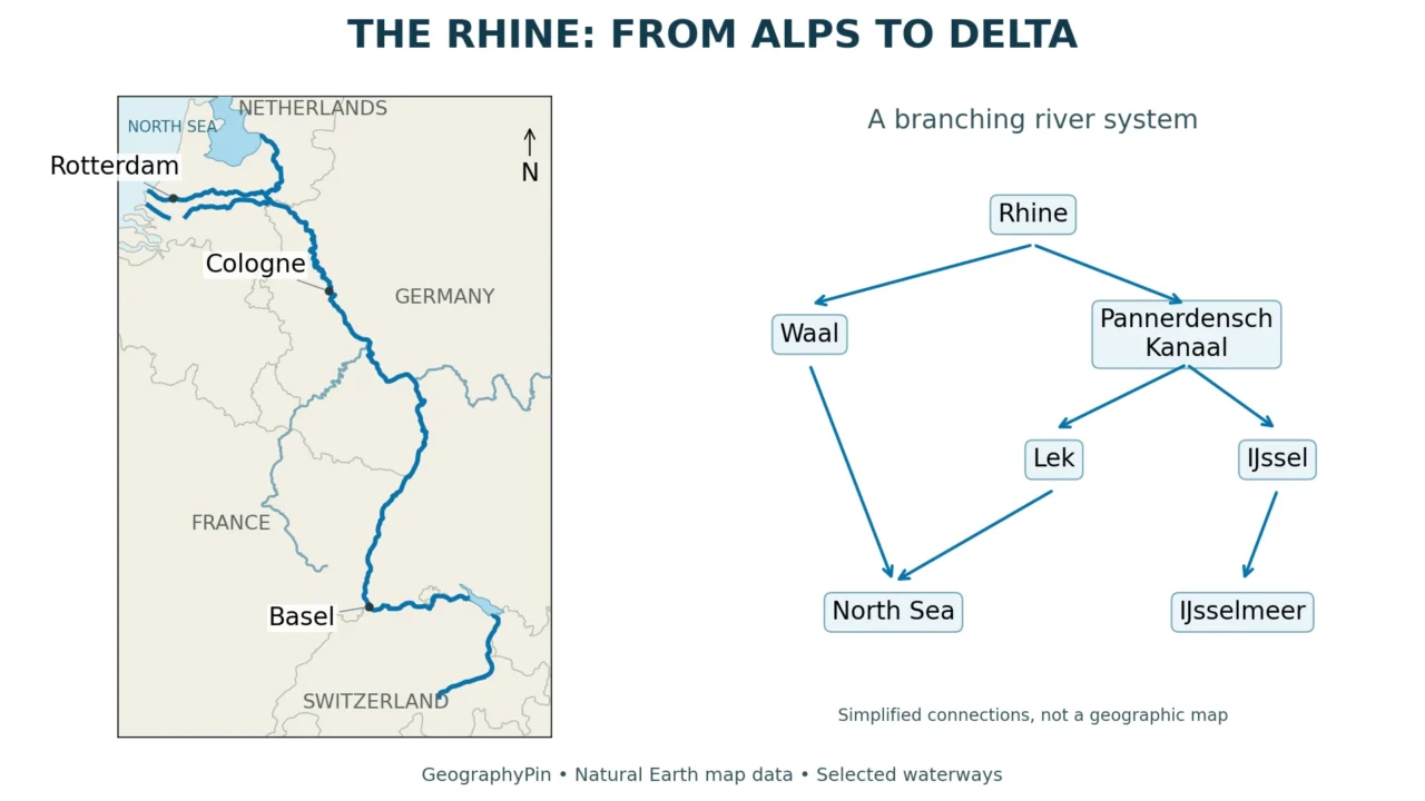
Rijkswaterstaat, the Dutch water-management authority, describes the Boven-Rijn dividing at the Pannerdensche Kop into the Waal and Pannerdensch Kanaal. Farther along the northern route, water is distributed between the Nederrijn and IJssel. The Nederrijn continues toward Wijk bij Duurstede, where the Lek and Kromme Rijn branches separate.
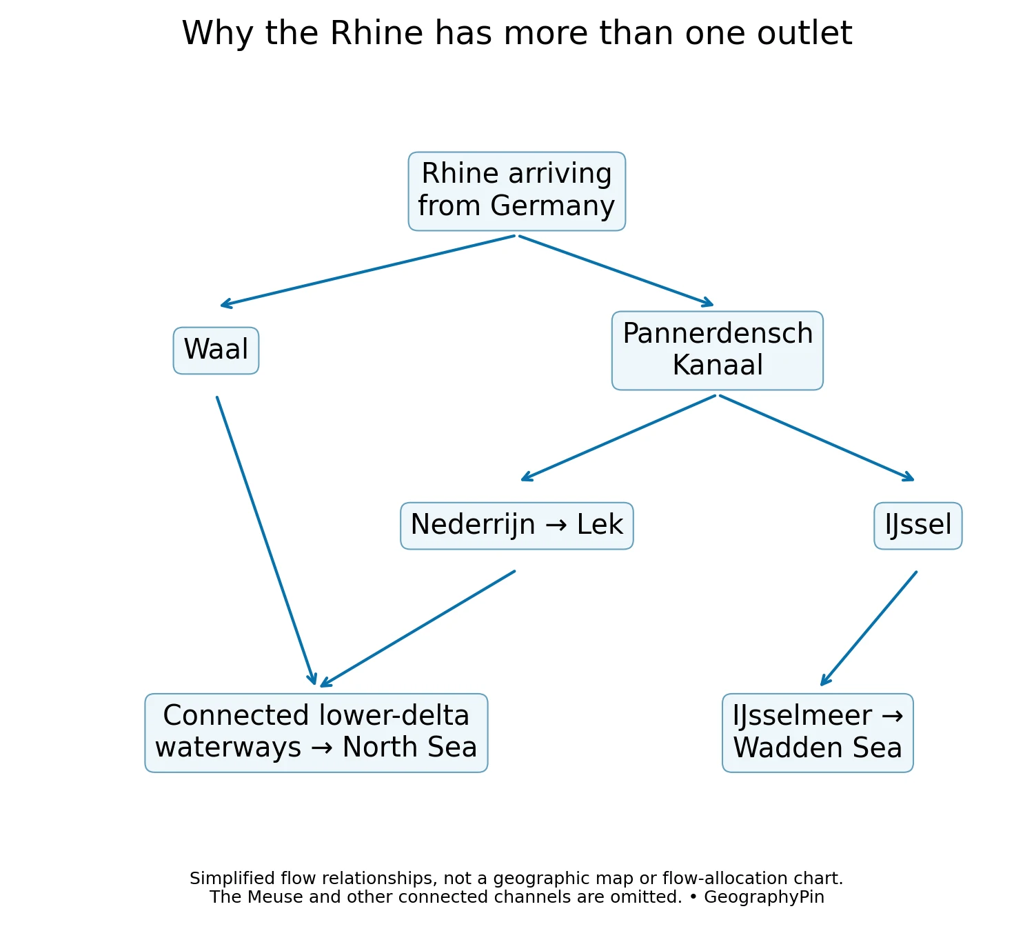
The Waal and Nederrijn–Lek connect into lower-delta waterways. These channels also interact with the Meuse, called the Maas in Dutch. That is why Rhine–Meuse delta is more informative than imagining two isolated rivers independently drawing straight lines to the coast.
The IJssel heads north into the IJsselmeer. Water from that lake is discharged toward the Wadden Sea through the managed Afsluitdijk system. It is a different route from the delta waterways around Rotterdam, and it should not be erased simply because a small atlas labels one coastal endpoint.
Channel names and engineered connections matter more here than a single “mouth coordinate.” The diagram shows relationships, not distances, exact channel positions or a constant percentage of water assigned to each branch. For local conditions, navigation and water levels, consult the relevant Dutch waterway information rather than using this educational overview as operational guidance.
6. Cities, tributaries and a working river
The Rhine is not only a line between the Alps and the sea. Tributaries bring in water from landscapes that the main stem never crosses. Important examples include the Aare, Neckar, Main and Moselle. On our map, the Main approaches from the east and the Moselle from the southwest; the Aare and Neckar are omitted at this overview scale, not absent from the real network.
City labels also need interpretation. Strasbourg’s historic center is associated with the Ill, while the wider city and port occupy the Rhine corridor. A dot for Strasbourg should therefore not be mistaken for a precise Rhine-bank landmark. Rotterdam likewise sits within the delta network. The city-center symbols are orientation aids, not port entrances or river-access directions.
The Lower Rhine links a densely populated and industrial region with the delta. ICPR identifies Cologne, Düsseldorf, Neuss and Duisburg among its important ports. This helps explain why river management involves transport and water supply alongside flood protection, ecological restoration and fish passage.
A stable route map cannot tell you whether a reach has enough water for a particular vessel today. Nor can a gauge number be treated automatically as water depth everywhere in the channel. Geography explains the corridor; current measurements and official navigation notices answer operational questions.
Frequently Asked Questions
Does the Rhine flow through France?
It follows part of the French–German border in the Upper Rhine corridor. Saying it runs through or along six countries is more precise than implying that it crosses the interior of all six.
Is the Rhine’s source in Germany?
No. Its alpine headwaters are in Switzerland. The Vorderrhein and Hinterrhein meet near Reichenau; Lake Toma is associated with the Vorderrhein source.
Does the Rhine end at Rotterdam?
Rotterdam is a useful delta landmark, but it is not the river system’s only outlet. The Rhine divides among connected waterways, including the northward IJssel–IJsselmeer route.
Are the Rhine and Danube the same river?
No. They are separate river systems. The Rhine drains toward the North Sea, while the Danube drains toward the Black Sea. A waterway connection between river systems does not make them one natural river.
What Did We Learn Today?
The Rhine connects Swiss alpine headwaters with the North Sea, but its geography is more complicated than one northbound line. Six countries lie along its course, nine contribute to the wider basin, and the Dutch delta distributes its water among several connected routes. Reading sources, tributaries, borders and distributaries separately makes the map more useful than memorizing a single length or mouth location.
Sources & Data Notes
The route map uses Natural Earth 1:10-million river, lake, country and city layers, rendered by GeographyPin. Lines and city centers are generalized; no catchment boundary, exact source coordinate or complete delta network is claimed. The latitude–longitude view uses a fixed aspect adjustment and is not suitable for measuring distances. The separate delta diagram is conceptual. Both are original GeographyPin graphics using public-domain base data and the authoritative descriptions below.
Length follows BfG’s 1,232.7 km figure, rounded in the overview. The approximately 200,000 km² area refers specifically to the International River Basin District. River-country and basin-country lists answer different questions. This is an evergreen geographic guide, not a live water-level report.
- BfG Undine: Rhine basin, length and kilometer marking
- ICPR: Alpine Rhine and Lake Constance
- ICPR: High Rhine
- ICPR: Upper Rhine
- ICPR: Middle Rhine
- ICPR: Lower Rhine
- ICPR: Delta Rhine
- IAWR: Rhine sections and tributaries
- Rijkswaterstaat: Boven-Rijn
- Rijkswaterstaat: Nederrijn
- Dutch Delta Programme: IJsselmeer area
- Natural Earth: public-domain data terms