The Gulf Stream, North Atlantic Current and AMOC often appear in the same climate story. They are connected, but the names describe different parts and scales of Atlantic circulation. A map helps separate the route from the larger system.
The Gulf Stream is the concentrated warm current along North America’s Atlantic margin and its offshore extension; the North Atlantic Current continues part of that flow toward the northern and eastern Atlantic. Both contribute to heat transport, but neither is the whole AMOC, which also includes deep return flows.
How to use this article: Start with the map, clarify where the names change, then distinguish gyres from overturning and observations from projections.
1. Follow the current system across the Atlantic
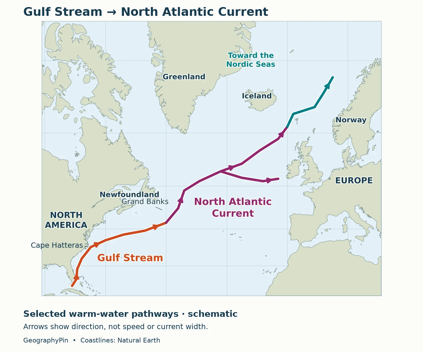
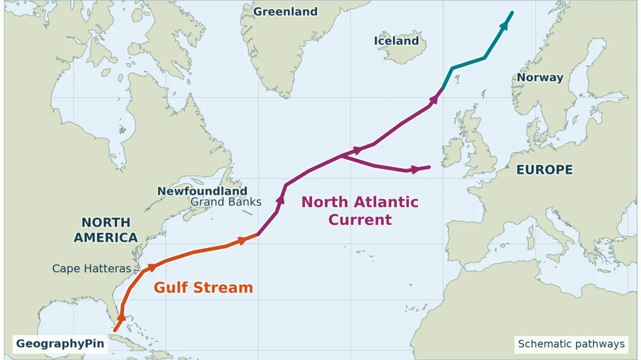
Start near Florida, follow the U.S. East Coast north, then look offshore toward Newfoundland and across the Atlantic. The route changes character along the way. A narrow, energetic current near North America becomes part of a branching system farther northeast, rather than remaining a single oceanic pipe all the way to Europe.

How to read the map
The arrows show generalized upper-ocean pathways, not the position of a current on a particular day. They do not measure speed, temperature or the volume of water transported. Real currents meander, divide and exchange water with neighboring flows. The map deliberately leaves out many smaller branches and recirculations so that the two names remain easy to follow.
Near Cape Hatteras, North Carolina, the Gulf Stream leaves the continental margin and flows into the open Atlantic. Its offshore extension proceeds toward the Grand Banks region southeast of Newfoundland. From that region, the North Atlantic Current carries water northward and then across the ocean. Atlantic water also continues into the Nordic Seas through connected branches.
The map is a geographic guide to that relationship, not an AMOC diagram: it does not depict the deep southward return flow. For the broader distinction between surface and deep circulation, see how ocean currents work.
2. Gulf Stream and North Atlantic Current compared
| Feature | Gulf Stream | North Atlantic Current |
|---|---|---|
| Main location | Western North Atlantic, along the U.S. coast and offshore toward the Grand Banks. | From the Grand Banks region into the northern and eastern North Atlantic. |
| Typical map appearance | A concentrated boundary current followed by an offshore jet. | A northward current that turns east and divides into multiple pathways. |
| Connection | Receives the Florida Current and supplies downstream flows. | Continues part of the Gulf Stream system toward higher latitudes. |
| Heat transport | Carries warm water poleward from lower latitudes. | Continues transferring relatively warm Atlantic water into cooler northern regions. |
| Naming caution | Sometimes used broadly for the connected system. | Often called the North Atlantic Drift; usage is not completely uniform. |
| Relation to AMOC | Contributes to the upper northward flow, but also participates in wind-driven circulation. | Part of the connected upper-ocean circulation, not the entire overturning system. |
“Western boundary” means the western side of the ocean basin. That is why a current on the eastern coast of North America can be a western boundary current. The reference is the Atlantic, not the continent.
Calling either current “warm” is also relative. Water transported from lower latitudes can be warmer than surrounding northern waters without being tropical by the time it reaches the northeastern Atlantic. The name does not promise one fixed temperature along the route.
3. Where does one name become the other?
The Grand Banks region, not a precise dividing line
The useful geographical transition is near and east of the Grand Banks, off Newfoundland. NOAA’s overview of Atlantic circulation describes the Gulf Stream from the Florida Straits to the Grand Banks and the North Atlantic Current crossing toward Europe. This is a clear introductory distinction, but it should not be mistaken for a surveyed boundary in the water.
Oceanographic usage is more detailed. In his review The North Atlantic Current and surrounding waters, T. Rossby describes a northward-flowing current along the eastern side of the Grand Banks before it turns east. Farther across the Atlantic, the flow spreads into a broader, less sharply bounded pattern. That description explains why an accurate map should not simply draw a straight diagonal arrow from Florida to Britain.
The American Meteorological Society glossary also uses “Gulf Stream Extension” for offshore continuation and recognizes overlapping terminology. A named current is a persistent circulation feature with variable structure, not a river confined by banks.
Is the North Atlantic Drift a different current?
Usually the term refers to the North Atlantic Current or its eastward and northeastward continuation. The AMS glossary explicitly lists North Atlantic Drift as an alternative name. Some explanations emphasize a broader drift farther east, so readers should check a map’s legend rather than assume every author draws exactly the same boundary.
The Gulf Stream itself does not run through the English Channel or directly along every European coastline. Its downstream connections transport Atlantic water across the basin and toward the northern seas. Naming those connections makes the geography clearer without pretending the flows are disconnected.
4. Why this is not the same thing as AMOC
AMOC stands for Atlantic Meridional Overturning Circulation. “Meridional” means north–south; “overturning” refers to the connection between upper and deeper water. The Gulf Stream and North Atlantic Current are named parts of the circulation, whereas AMOC describes a much larger pattern involving northward upper-ocean transport and southward transport at depth.
Horizontal gyres and vertical overturning
A gyre is a large-scale circulation around an ocean basin. Winds help organize the North Atlantic subtropical gyre, while Earth’s rotation influences its motion. The Gulf Stream is the strong western side of that circulation. The Coriolis effect explains the rotational deflection, but it does not provide the energy that starts the flow.
Overturning adds another dimension. As water loses heat in northern regions, its density can increase enough for it to enter deeper layers. Temperature and salt content both matter; winds, mixing and the wider ocean circulation matter too. The familiar conveyor-belt picture is useful for orientation but simplifies a system of interacting currents and eddies.
A water parcel need not travel from Florida to the far north before returning. Some water recirculates within the subtropical Atlantic. Therefore, the total flow through the Gulf Stream is not interchangeable with the net strength of the AMOC measured across an entire latitude.
As Woods Hole Oceanographic Institution explains, weakening or collapse of overturning does not mean the wind-driven Gulf Stream simply switches off. This does not make it immune to climate change: its temperature, path and transport can still change. The important correction is to identify which part of the circulation a claim concerns.
5. How the currents influence Europe’s climate
Ocean circulation redistributes heat rather than creating it. Water arriving from lower latitudes carries stored energy into cooler regions and exchanges heat with the atmosphere. The Gulf Stream–North Atlantic Current system is therefore an important part of the North Atlantic climate, but it is not the only reason European winters differ from winters elsewhere at the same latitude.
Prevailing winds, the ocean’s ability to store heat, the arrangement of land and sea, and atmospheric circulation all help shape regional temperatures. A comparison between one European city and one North American city does not isolate the contribution of a single ocean current. Nor does a current map predict the weather for a particular week.
Jaime Palter’s 2015 review of the Gulf Stream’s role in European climate describes connections involving the ocean, atmosphere and ice, with effects on temperature, rainfall and storminess over decades and longer. That is a more useful framework than treating the current as a thermostat with one setting for an entire continent.
There are two different questions here: how much ocean heat transport contributes to today’s climate, and how a change in circulation would affect a future climate already influenced by greenhouse warming. They cannot be answered by reading the same current arrow twice. GeographyPin’s explanation of weather versus climate provides the timescale distinction.
6. What weakening claims can and cannot tell us
Established processes versus future projections
Warming and freshening can make northern surface water less dense, affecting its ability to enter deeper layers. The National Oceanography Centre explains why these changes matter for overturning and why sustained observations are essential. They establish a physical concern, not a calendar date for collapse.
The Met Office’s May 2024 explanation reports the IPCC Sixth Assessment’s conclusion that AMOC weakening during this century is very likely, with medium confidence that an abrupt collapse will not occur before 2100. “Medium confidence” is not certainty, and this dated assessment should not be presented as proof that the risk is zero.
A February 2025 Met Office-led modeling study found continued overturning under extreme forcing in its experiments, while still expecting weakening. It illustrates why “weaker” and “completely stopped” are different outcomes. Individual modeling studies do not settle all uncertainties about future thresholds, timing or regional impacts.
Reduced northward heat transport can mean less warming in a region than would occur otherwise, rather than necessarily colder conditions than today. Much stronger disruption could produce a different response. The result depends on the circulation change, greenhouse warming and atmospheric adjustments, so a single promised temperature drop for all of Europe would be misleading.
When evaluating a headline, ask three questions: does it concern a particular current or the basin-wide AMOC; does it report observations or a model experiment; and what period, location and assumptions does it use? A 2024 synthesis of observations found different decadal behavior in different parts of the system. A surface-current measurement at one place cannot, on its own, describe the entire overturning circulation.
Frequently Asked Questions
Is the Gulf Stream the same as the jet stream?
No. The Gulf Stream is moving seawater. A jet stream is a fast-moving band of air high in the atmosphere. Ocean and atmospheric circulation interact, but a map of one is not a map of the other.
Can satellite images show where the Gulf Stream is?
They can help reveal its surface structure, including temperature contrasts and sea-surface-height patterns. That is not a complete view of transport through the water column; measurements below the surface are needed as well.
Why are there no speed numbers on this map?
A single speed would conceal differences between the current core and its edges, between depths, and between locations and dates. These arrows identify the current system; they are not a navigation forecast or a measured velocity chart.
What Did We Learn Today?
The two current names describe connected but geographically different flows. Following the Gulf Stream offshore toward the Grand Banks, then the North Atlantic Current into the northern Atlantic, is more accurate than imagining one unchanging stream to Europe. Their heat transport matters, but European climate has several influences. AMOC adds the deep return circulation, so changes to overturning cannot be translated directly into the disappearance of every surface current.
Sources & Data Notes
The map uses generalized pathways and a Natural Earth basemap, not measured current boundaries or real-time tracks. Names overlap between sources. The climate discussion identifies the dates of the assessments and studies it describes; it is not a prediction of a collapse year. Sources on routes and terminology are kept separate from evidence about future change.
- NOAA NCEI: Decades of Data on a Changing Atlantic Circulation (2024)
- American Meteorological Society: Gulf Stream
- American Meteorological Society: North Atlantic Current
- Rossby (1996): The North Atlantic Current and surrounding waters
- WHOI: Will the Gulf Stream really shut down? (2023)
- Palter (2015): The Role of the Gulf Stream in European Climate
- National Oceanography Centre: Understanding the AMOC
- Met Office: The AMOC in a changing climate (2024)
- Met Office: AMOC likely to withstand future warming (2025)
- Asbjørnsen et al. (2024): Observed change and the extent of coherence in the Gulf Stream system
- Natural Earth: public-domain basemap terms