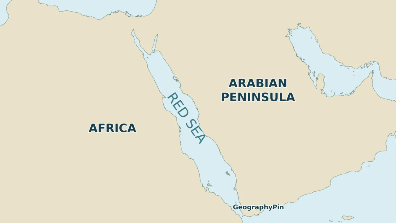
A Red Sea map becomes much easier to read once its two northern gulfs and southern entrance are separated. The country count changes with that scope, while the route to the Mediterranean depends on a canal rather than a natural strait.
The Red Sea lies between Africa and Arabia. Six countries border its main basin and southern entrance; including the Gulf of Aqaba adds Israel and Jordan, making eight. Bab el-Mandeb connects it naturally to the Gulf of Aden, while the Gulf of Suez and Suez Canal lead north to the Mediterranean.
How to use this article: Check the six-versus-eight rule, compare the western gulf with Aqaba, or trace the ocean connections.
1. Locate the Red Sea and Its Two Northern Arms
The Red Sea lies between northeastern Africa and the Arabian Peninsula. Its main basin trends northwest–southeast, with Egypt, Sudan and Eritrea along the African shore and Saudi Arabia and Yemen opposite them. Djibouti reaches the southern entrance.
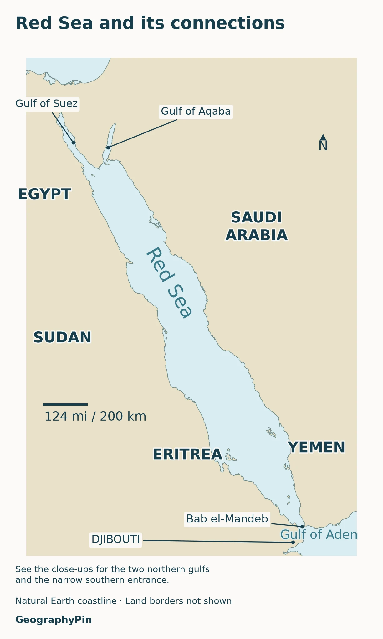
At the top of the sea, the Sinai Peninsula divides two branches. The Gulf of Suez lies to the west of Sinai; the Gulf of Aqaba lies to its east. They are not two names for the same gulf. At the opposite end, Bab el-Mandeb provides the natural passage to the Gulf of Aden.
Country names provide land context; political boundary lines are omitted. The map does not divide the water into territorial seas or exclusive economic zones. A country name near a coast identifies the neighboring land, not ownership of the whole sea beside it.
For a wider view of the African side, use the Africa country maps. The Middle East country reference explains the broader regional label, which is not the same thing as a Red Sea coastline.
2. Which Countries Border the Red Sea?
Why the answer can be six or eight
Six countries border the Red Sea proper and its southern entrance: Egypt, Sudan, Eritrea, Djibouti, Saudi Arabia and Yemen. Include the northern gulfs and the count becomes eight, because Israel and Jordan have shores on the Gulf of Aqaba. Egypt and Saudi Arabia already appear in the six-country group, so they are not counted again.
This distinction follows the physical parts of the sea rather than membership in a regional organization. The Convention on Migratory Species’ Red Sea dugong overview identifies the six main-basin coastal states separately from the four countries around Aqaba. The International Hydrographic Organization’s Limits of Oceans and Seas also distinguishes the main sea from the two northern gulfs.
A coast table with the scope made explicit
| Country | Coast within this reference | Included in |
|---|---|---|
| Egypt | Main Red Sea; Gulf of Suez; Gulf of Aqaba | Both the six- and eight-country totals |
| Sudan | Main Red Sea, African side | Both totals |
| Eritrea | Main Red Sea, African side | Both totals |
| Djibouti | Southern entrance at Bab el-Mandeb | Both totals |
| Saudi Arabia | Main Red Sea; Gulf of Aqaba | Both totals |
| Yemen | Main Red Sea and Bab el-Mandeb | Both totals |
| Israel | Northern Gulf of Aqaba | Eight-country total only |
| Jordan | Northern Gulf of Aqaba | Eight-country total only |
The Gulf of Suez adds no country to either list: its coasts are Egyptian. The Gulf of Aqaba has four coastal countries, but adds only two to the wider total. That difference between “countries around one gulf” and “additional countries” is the source of many inconsistent lists.
Somalia is not a ninth Red Sea country under this scope. It borders the Gulf of Aden, which belongs to the wider Red Sea–Gulf of Aden regional setting. A report covering both water bodies can therefore include Somalia without contradicting an eight-country Red Sea-and-gulfs list.
The count does not settle disputed land boundaries. Egypt and Sudan dispute the Halaib area on their shared coastal frontier. Both Egypt and Sudan have undisputed Red Sea coastlines, so the dispute does not change the number of countries in this table.
3. Read the Northern Connections
Gulf of Suez: the western branch
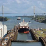
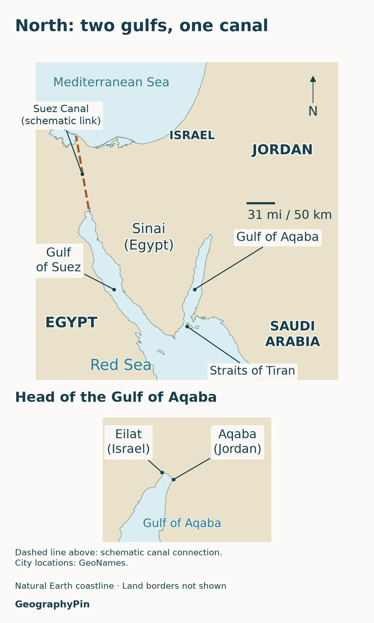
Follow the western side of Sinai northward and you enter the Gulf of Suez. At its northern end, the Suez Canal continues across Egypt to the Mediterranean. The gulf is a natural arm of the Red Sea; the canal is an artificial waterway. Calling the entire connection “Suez” without distinguishing those two features hides an important change in the route.
The Suez Canal Authority describes the canal as a sea-level waterway between Port Said and the Gulf of Suez. On a regional map the canal is too narrow to show at its true width, which is why the connection is represented by a schematic line. It should not be mistaken for a broad natural strait.
Gulf of Aqaba: the eastern branch
The Gulf of Aqaba extends northeastward between Sinai and northwestern Saudi Arabia. Egypt lies on its western side; Saudi Arabia lies on its eastern side, with Israel and Jordan meeting the head of the gulf. Eilat is on the Israeli coast and Aqaba is on the Jordanian coast.
At the gulf’s southern entrance, the Strait of Tiran, also called the Straits of Tiran, links Aqaba with the main Red Sea. NASA’s astronaut-image explanation identifies the passages around Tiran Island. This is the connection that a sea route from Aqaba or Eilat must use to reach the main basin.
The two northern arms therefore play different roles in a connection map. Suez leads toward the canal and Mediterranean; Aqaba leads toward the short Israeli and Jordanian coastlines. There is no natural northward passage from the head of Aqaba into the Mediterranean or the Dead Sea.
4. Follow Bab el-Mandeb Toward the Indian Ocean
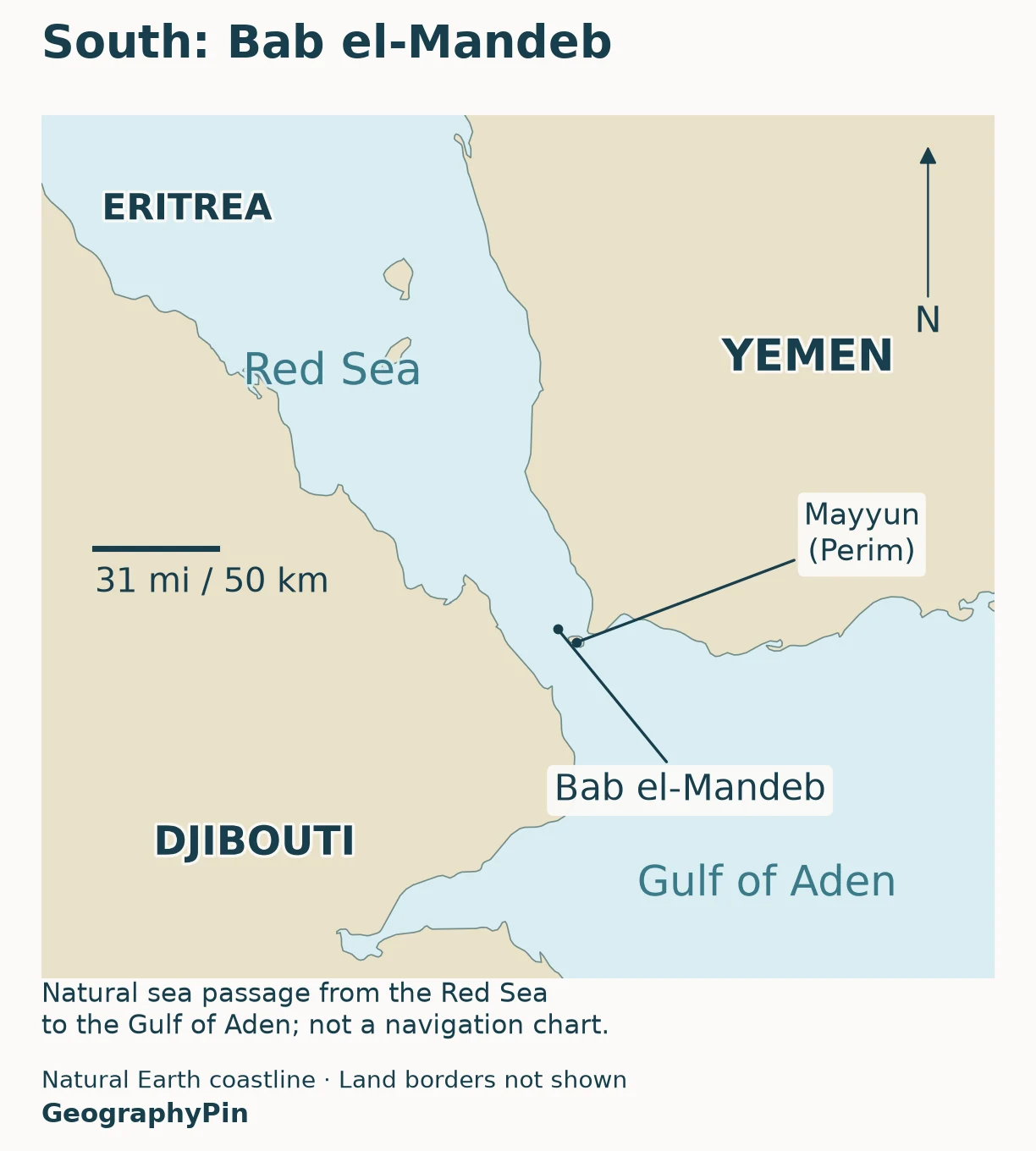
Bab el-Mandeb is the natural southern gateway. Yemen lies on the Arabian side, while Djibouti and nearby Eritrean coast form the African setting. Beyond the strait, the Gulf of Aden opens eastward toward the Arabian Sea and the wider Indian Ocean.
A strait is a natural water passage connecting larger waters while separating land. Bab el-Mandeb fits that definition; the Suez Canal does not, because it was constructed across land. Both can be important connections without being the same kind of landform.
The IHO’s 1953 sea-limit reference places the southern limit of the Red Sea on a line between Ras Siyan on the African coast and Husn Murad in Yemen. Such a reference line gives adjoining named sea areas a conventional division. It is not a wall in the water, a current boundary or an international land border.
Trace the two water connections
| Direction | Sequence | Type of connection |
|---|---|---|
| South and east | Red Sea → Bab el-Mandeb → Gulf of Aden → Arabian Sea → Indian Ocean | Natural sea connection |
| North and west | Red Sea → Gulf of Suez → Suez Canal → Mediterranean → Strait of Gibraltar → Atlantic | Includes the artificial Suez Canal |
5. Understand What the Map Does and Does Not Show
The Red Sea’s long, narrow shape reflects the separation of Africa and Arabia. NASA describes the basin as a rift where tectonic plates are moving apart. That broad geologic setting helps explain the opposing coasts, but a country map is not a map of active faults, seafloor spreading rates or earthquake risk.
Likewise, an uninterrupted blue area does not mean uniform depth. Coastlines, reefs, islands and narrow passages matter at smaller scales. A generalized basemap deliberately leaves out details that cannot be shown reliably at regional size.
A coastline list is not an organization’s membership list
PERSGA works across the Red Sea and Gulf of Aden region. Its geographic remit is broader than this article’s main-sea count, and its member-country list is not a substitute for tracing every coast. Before comparing any two totals, check whether each source includes Aqaba, Suez, the Gulf of Aden, or only the main basin.
The same discipline applies to map colors. The neutral land fill is an orientation aid, not a claim that each country controls nearby international waters. Political boundary lines are omitted rather than presenting a disputed line as settled.
This is an evergreen geography reference, not a live shipping-security or travel advisory. It does not report attacks, restrictions, insurance conditions, port availability or whether a route is operating today. Those are time-sensitive questions requiring current notices from the relevant authorities.
Frequently Asked Questions
Is the Red Sea the same as the Dead Sea?
No. The Red Sea connects to the ocean. The Dead Sea is an inland salt lake in the Jordan Rift Valley, without a natural outlet to the world ocean. Similar names do not mean they are connected.
Does the Red Sea connect to the Persian Gulf?
Not directly. A sea route between them goes through Bab el-Mandeb, the Gulf of Aden, the Arabian Sea, the Gulf of Oman and the Strait of Hormuz. The Persian Gulf is a different body of water on the other side of the Arabian Peninsula.
What Did We Learn Today?
A reliable Red Sea map needs a declared scope. The main sea and its entrance have six coastal countries; Aqaba adds two more. Sinai separates the two northern gulfs, Suez provides the artificial Mediterranean connection, and Bab el-Mandeb provides the natural Indian Ocean connection. Keeping coastlines, named sea limits and navigational conditions separate prevents the most common map-reading mistakes.
Sources & Data Notes
The six-country count covers the main Red Sea and southern entrance; the eight-country count adds the northern gulfs and excludes the Gulf of Aden. Maps use generalized Natural Earth land geometry, with connection labels checked against the sources below. Canal depiction is schematic, not surveyed navigation geometry. Country labels do not indicate maritime jurisdiction; political boundary lines are omitted rather than resolving disputed areas. Shipping and travel conditions are outside this reference’s scope.
- International Hydrographic Organization: Limits of Oceans and Seas, 1953, sections 35–38
- European Commission CORDIS: Sustainable management of the Gulf of Aqaba
- Carnegie: The Egypt–Sudan Border, Halaib dispute context
- Convention on Migratory Species: Red Sea regional overview, section 3.1.1
- Suez Canal Authority: About Suez Canal
- NASA Earth Observatory: Strait of Tiran, Red Sea and Gulf of Aqaba
- NASA Earth Observatory: Chlorophyll and Currents in the Red Sea
- PERSGA: State of the Marine Environment Report for the Red Sea and Gulf of Aden, regional scope
- Natural Earth: public-domain map-data terms