A blue river line tells only part of the Colorado’s story. The larger drainage basin explains where its tributaries gather water; reservoirs, diversions and the Mexican delta explain why following that line is not the same as following uninterrupted flow to the sea.
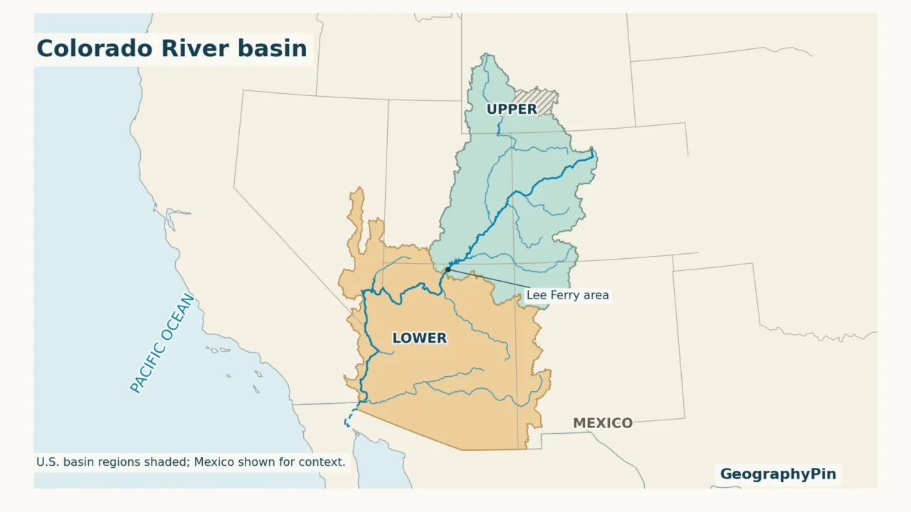
The Colorado River basin extends across parts of seven western U.S. states and northern Mexico, from Rocky Mountain headwaters toward the Gulf of California. Lee Ferry in Arizona separates the Upper and Lower Basins. Its natural drainage area differs from the places receiving diverted water, and a mapped channel does not guarantee continuous flow.
How to use this article: Separate drainage from delivery areas, locate the basin division, follow the reservoir sequence, or interpret the delta’s flow context.
1. Read the Colorado River basin map
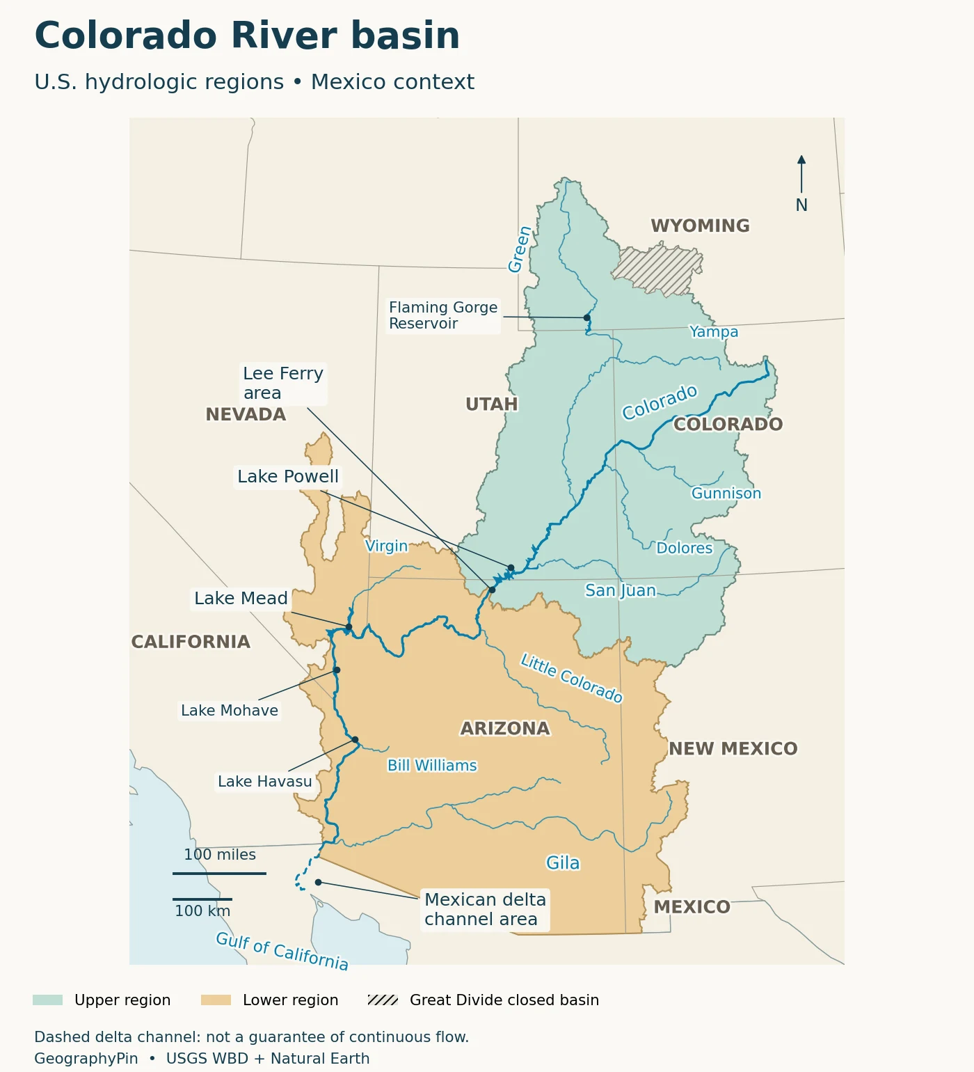
The Colorado River begins in the Rocky Mountains of Colorado. Its course runs into Utah, through northern Arizona and the Grand Canyon, then south along parts of Arizona’s boundaries with Nevada and California. Beyond the U.S.–Mexico border, its lower channel and delta lead toward the Gulf of California.
A drainage basin is the land connected to a river system by its natural drainage pathways. It includes mountain slopes, tributary valleys and desert washes, not just land beside the main river. A divide separates it from neighboring drainage systems. For the larger terrain pattern, compare the physical map of the United States.
Drainage basin versus water-delivery area
A city can receive Colorado River water without lying inside the river’s natural drainage basin. Tunnels, canals and aqueducts carry water across divides. Reclamation’s 2012 basin study therefore mapped both the U.S. hydrologic basin and adjacent areas receiving Colorado River water, using different symbols.
That distinction matters in southern California and along Colorado’s Front Range. Imported water does not make every receiving community part of the natural watershed. Conversely, land can lie inside the watershed even if its streams are intermittent or much of its precipitation evaporates before reaching the river.
The map uses the U.S. Geological Survey’s Watershed Boundary Dataset. Its regional units can include noncontributing areas: the Great Divide Closed Basin in Wyoming is a clear example, distinguished by hatching here. Mexico remains unshaded because this map does not supply a Mexican drainage boundary. Read any basin map’s legend before comparing its outline with another map. A natural drainage boundary, a water-management region and the territory served by a delivery project answer different questions. None, by itself, tells you how much water a particular user is entitled to take.
2. States, Upper Basin and Lower Basin
The seven U.S. basin states are Arizona, California, Colorado, Nevada, New Mexico, Utah and Wyoming. The river system continues into Mexico, where Baja California and Sonora frame the lower river and delta. These are not nine whole states draining uniformly into one river; the basin occupies portions of them.
The dividing point is Lee Ferry
The 1922 Colorado River Compact defines Lee Ferry as a point in the main river 1 mile (1.6 kilometers) below the mouth of the Paria River in Arizona. It separates the Upper and Lower Basins. This is not the Utah–Arizona state line, and it is not Glen Canyon Dam.
The nearby historic crossing and stream-gaging site are generally called Lees Ferry, distinguished from the legal point in Reclamation’s basin map. The legal point is downstream. On a whole-basin map these places may look almost coincident, but the names should not be treated as interchangeable in a precise measurement or legal description.
| Term | Meaning |
|---|---|
| Upper Division states | Colorado, New Mexico, Utah and Wyoming: the Compact’s four-state legal grouping. |
| Lower Division states | Arizona, California and Nevada: the Compact’s three-state legal grouping. |
| Upper drainage basin | Land draining into the system above Lee Ferry, including a portion of Arizona. |
| Lower drainage basin | Land draining into the system below Lee Ferry, including portions of Utah and New Mexico. |
The Compact’s own definitions of “Basin” also include territory outside natural drainage areas that is beneficially served by diverted water. That legal meaning is broader than the hydrologic shading used here. The distinctions follow Article II of the Compact; they are not a map of modern delivery allocations.
For state-level context, Colorado’s mountain and plains geography explains why only part of Colorado drains west into this system. New Mexico’s geography likewise spans more than one major drainage system.
3. Major tributaries and their connections
A tributary need not join the Colorado directly to belong to its basin. Follow the connections downstream: the Yampa joins the Green, which joins the Colorado; the Salt joins the Gila, which meets the Colorado near Yuma. That branching structure is more useful than memorizing an unconnected list of names.
| River or group | Connection to follow | Geographic clue |
|---|---|---|
| Green River | Joins the Colorado in southeastern Utah | Headwaters in Wyoming; the Yampa and White feed the Green system. |
| Gunnison River | Joins the Colorado in western Colorado | A major mountain-fed branch upstream of the Green confluence. |
| Dolores River | Joins the Colorado in Utah | Drains part of southwestern Colorado and adjacent Utah. |
| San Juan River | Enters the Colorado system at Lake Powell | Links southwestern Colorado, northwestern New Mexico and southeastern Utah. |
| Little Colorado River | Joins the Colorado in northern Arizona | Part of the Lower Basin, despite its similar name. |
| Virgin River | Enters the Lake Mead reach | Connects southwestern Utah, northwestern Arizona and southern Nevada. |
| Bill Williams River | Enters Lake Havasu | An Arizona tributary of the lower main stem. |
| Gila River | Meets the Colorado near Yuma | Extends from New Mexico across Arizona; its network includes the Salt River. |
The National Park Service’s Green and Yampa account illustrates the hierarchy: the Yampa and Green meet at Echo Park in Dinosaur National Monument, long before the Green reaches the Colorado. The line reaching a confluence on a reference map does not guarantee uninterrupted surface flow at that junction every day.
Mountain snowmelt is particularly important in the upper river system, while lower-basin runoff also responds to rainfall and desert storms. Reservoirs and withdrawals alter the timing and amount of water moving through both. The network shows where water can travel, not a fixed contribution from every tributary.
4. Follow the reservoirs toward the delta
Read the main stem in downstream order
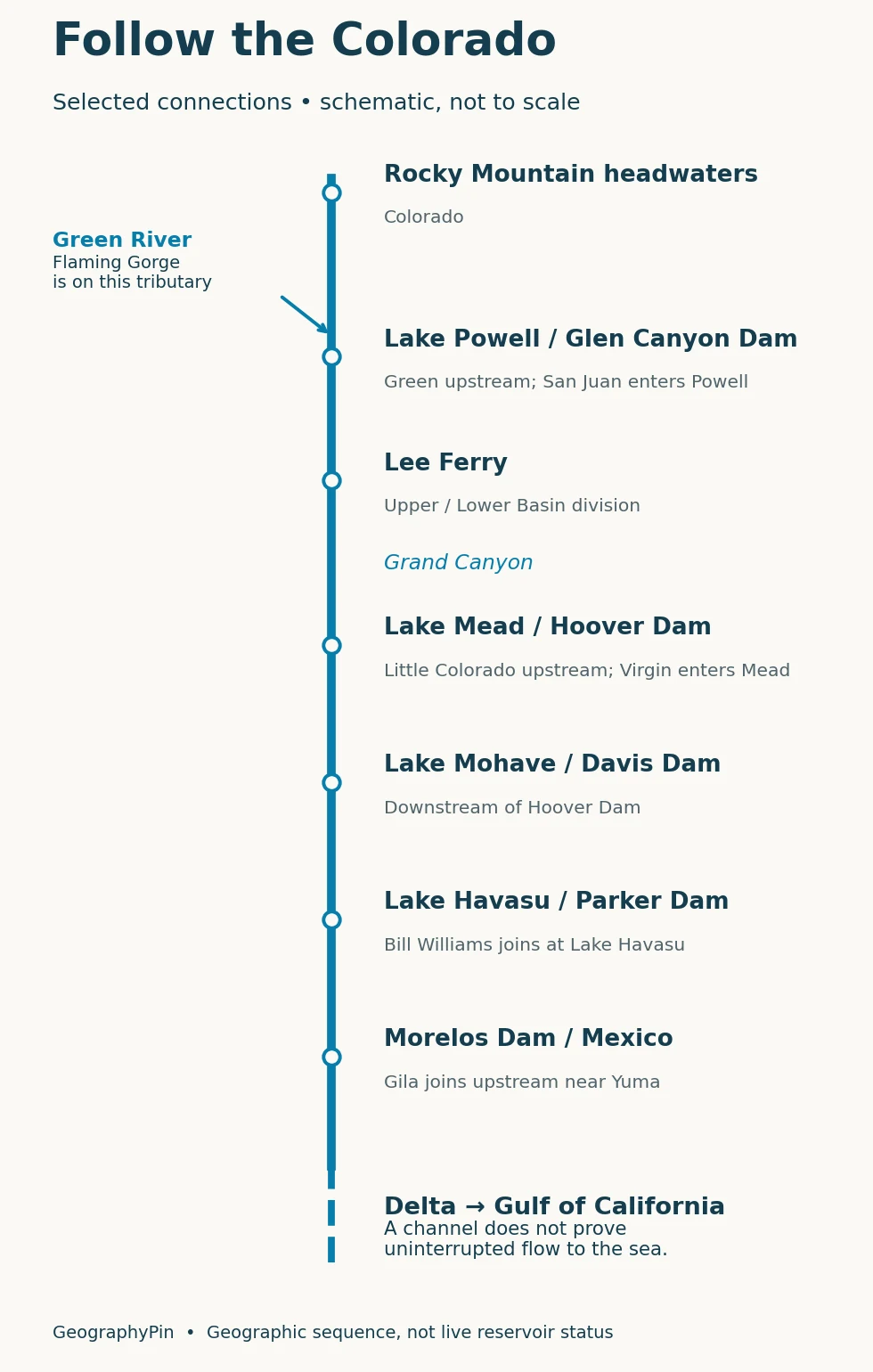
The key main-stem reservoir sequence is Lake Powell → Lake Mead → Lake Mohave → Lake Havasu. Glen Canyon Dam impounds Lake Powell; Hoover Dam impounds Lake Mead; Davis Dam impounds Lake Mohave; Parker Dam impounds Lake Havasu. Lee Ferry and the Grand Canyon lie downstream of Glen Canyon Dam and upstream of Lake Mead.
Other well-known reservoirs sit on tributaries. Flaming Gorge is on the Green River, Blue Mesa is on the Gunnison, and Navajo Reservoir is on the San Juan. They are part of the same connected water system, but a journey down the Colorado main stem does not pass through all three.
Farther downstream, diversion works redirect water into canals and irrigation systems. Imperial Dam lies upstream of Yuma; Morelos Dam is at the U.S.–Mexico border reach. These structures help explain why a downstream river line and a water-delivery route are not necessarily the same thing.
Reservoirs store water and change the timing of releases. They do not create a new supply of runoff. Lake shapes on a reference map also should not be used to estimate today’s storage: shorelines move with water levels, and storage requires a reservoir-specific measurement.
5. The Mexican delta and the question of flow
A mapped channel is not a live-flow report
The Colorado’s geographic outlet is the Gulf of California, also called the Sea of Cortez. Its delta lies in northern Mexico, between Baja California and Sonora. That geography remains meaningful even when a continuous freshwater connection from upstream is absent.
Water diversions, consumptive use, reservoir operations and losses along the lower system have greatly reduced freshwater reaching the delta. Drought and heat add pressure. A map that carries a blue line to the gulf therefore identifies a river course, not evidence that water is currently traveling along its entire length.
The opposite absolute claim, that the river can never reach the sea, is also wrong. A documented environmental pulse release in 2014 reconnected water through the delta to the sea. USGS researchers examined the resulting channel changes and infiltration losses. It was a particular managed event, not proof of permanent year-round reconnection.
Flow-context evidence: A USGS Land Imaging Report summary distinguishes the 2014 pulse flow from in-channel environmental deliveries at selected delta sites in 2021–2022. Water supplied to restoration sites is not equivalent to continuous flow along the entire river to the gulf. These are dated observations, not a live assessment of today’s mouth conditions.
For present conditions, consult station-specific measurements and reservoir-operation reports, noting the date and location. A release measured below one dam cannot by itself establish what reaches the sea after intervening diversions and channel losses.
Frequently Asked Questions
Is this the Colorado River in Texas?
No. Texas has a separate Colorado River that drains toward the Gulf of Mexico. The western river shown here crosses the Colorado Plateau and continues toward the Gulf of California. The shared name does not indicate a connection between their basins.
Is the whole state of Colorado in this basin?
No. The Continental Divide separates drainage within the state. In Rocky Mountain National Park, for example, west-side waters enter the Colorado River system, while east-side streams belong to the Mississippi drainage. A state boundary is not a watershed boundary.
What Did We Learn Today?
Read the Colorado River basin as a connected drainage network, then add the management layer. Tributaries bring together land across state and national borders; Lee Ferry separates the two basins without following a state line; reservoirs and diversions reshape the water’s journey. At the Mexican delta, the distinction between a geographic river course and actual measured flow becomes essential.
Sources & Data Notes
Geographic connections and the Compact’s definitions are distinguished from operational conditions. The 2012 study is used for drainage versus service-area mapping, not present-day demand totals. The 2026 operating plan supports the reservoir-system context, not a claim that projected releases occurred. Delta examples retain their observation years; no real-time mouth-flow or current reservoir-level claim is made.
Original map design: GeographyPin. The U.S. shading uses USGS Watershed Boundary Dataset regions 14 and 15, clipped at the national border, with Great Divide Closed Basin separately hatched. Rivers, lakes and political outlines use public-domain Natural Earth cartography. Lambert conformal conic projection preserves regional shape; the reservoir route strip is schematic. The dashed lower channel is a warning about flow interpretation, not a measured dry-reach boundary. Mexico’s drainage perimeter and water-delivery service areas are not mapped.
- Colorado River Compact (1922), Article II: basin and division definitions
- Reclamation: 2012 Water Supply and Demand Study, executive summary and study-area map
- Reclamation: 2026 Annual Operating Plan for Colorado River Reservoirs
- National Park Service: Southwest River Environments
- National Park Service: Green and Yampa Rivers
- National Park Service: Rocky Mountain National Park drainage divide
- USGS: geomorphic response to the 2014 delta pulse flow
- USGS: Colorado Delta Riparian Growth and Water Use
- Texas Water Development Board: the separate Colorado River basin in Texas
- USGS: Upper Colorado hydrologic region and Great Divide Closed Basin
- USGS: Watershed Boundary Dataset definitions and attributes