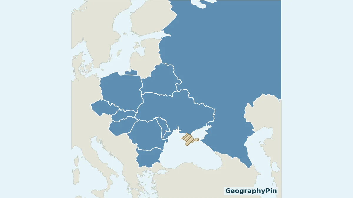
An Eastern Europe list is only useful when its boundaries are explained. This map uses the United Nations statistical grouping, so you can match each highlighted country to a named capital without mixing several regional definitions.
The ten Eastern European countries in UN M49 are Belarus, Bulgaria, Czechia, Hungary, Poland, Moldova, Romania, Russia, Slovakia and Ukraine. This is a statistical grouping, not a universal cultural boundary. Russia belongs to the group as a whole country, even though much of its territory lies geographically in Asia.
How to use this article: compare regional definitions, see why all of Russia is included, download the practice maps.
1. Eastern Europe Map and the Ten-Country List
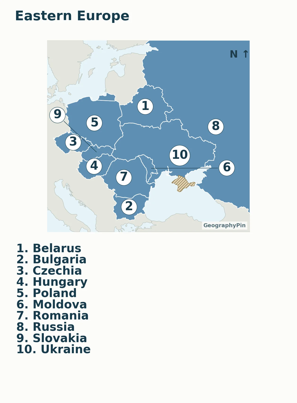
Numbers identify countries, not capitals or rankings. The complete key is immediately below the map. Gray land is outside this ten-country grouping; the main view is cropped to keep the smaller countries readable.
| Map no. | Country | Capital |
|---|---|---|
| 1 | Belarus | Minsk |
| 2 | Bulgaria | Sofia |
| 3 | Czechia | Prague |
| 4 | Hungary | Budapest |
| 5 | Poland | Warsaw |
| 6 | Moldova | Chișinău |
| 7 | Romania | Bucharest |
| 8 | Russia | Moscow |
| 9 | Slovakia | Bratislava |
| 10 | Ukraine | Kyiv |
Moldova is listed as “Republic of Moldova” and Russia as “Russian Federation” in M49. Czechia is the short name used here; Czech Republic refers to the same country. The table uses Kyiv and the local spelling Chișinău, also commonly rendered Chisinau without diacritics.
These ten capitals are not a list of every European capital. For the wider comparison, use the existing Europe countries and capitals reference, whose broader inclusion rule is explained separately.
2. What “Eastern Europe” Means Here
Statistical regions are not cultural identities
The UN Statistics Division places every country or area in one geographic region for statistical work. Its Eastern Europe category is therefore a reproducible way to build a table, not a ruling on how people must describe their history, culture or identity. M49 explicitly says that regional assignment does not imply political or other affiliation.
Poland, Czechia, Hungary and Slovakia are included in this statistical group even when a different reference describes them as Central European. Those descriptions answer a different question. A map using one convention should name it rather than quietly combining the membership of several.
The Baltic states, Estonia, Latvia and Lithuania, are assigned to Northern Europe in M49. Albania and Serbia belong to its Southern Europe grouping. Georgia, Armenia and Azerbaijan are placed in Western Asia. Their absence from this map does not deny historical connections with Eastern Europe or settle debates about Europe’s physical boundary.
Russia is counted as one whole country
Russia is transcontinental, but M49 assigns the Russian Federation to Eastern Europe without splitting it between statistical regions. The overview below consequently highlights its territory across northern Eurasia. It should not be read as a claim that Siberia is physically part of Europe.
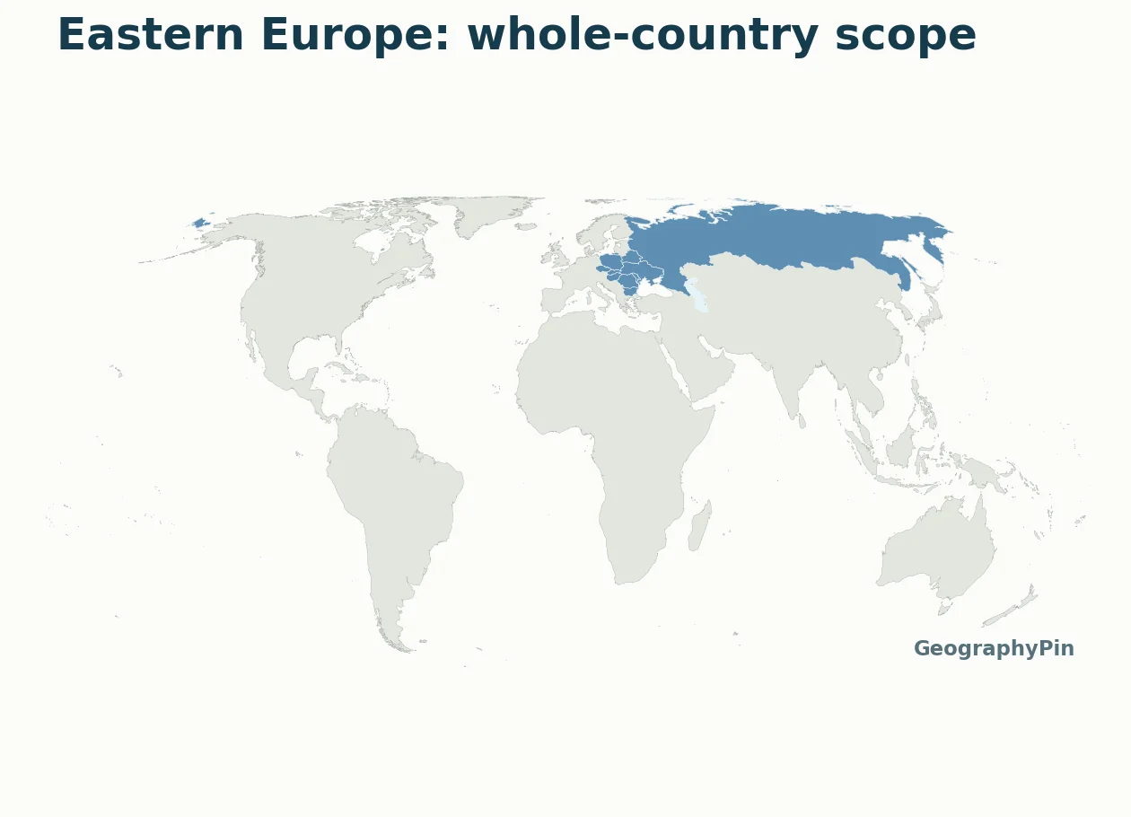
The regional close-up and the world overview answer complementary questions: the first helps you identify the smaller countries; the second prevents the cropped Russian outline from becoming a misleading statement about regional membership.
3. How to Read the Region Geographically
Start with Poland and Belarus near the northern side of the close-up. Czechia and Slovakia lie farther southwest, with Hungary below Slovakia. Romania and Bulgaria form the southern part of this selected group; Moldova lies between Romania and Ukraine. Russia occupies the northeast and continues far beyond the regional frame.
The map is deliberately political and classificatory. Its colors do not represent elevation, language, religion, alliances or development. A shared fill means only that the countries are in the same M49 category. The numbers are placed within country polygons where space permits; leader lines identify the smaller countries when a number must be moved.
Borders and the Crimea annotation
The cartography follows Ukraine’s internationally recognized territorial scope. The Crimea geometry supplied by Natural Earth was reassigned from its default de facto presentation to Ukraine and marked with hatching. The UN General Assembly reaffirmed Ukraine’s territorial integrity in resolution 68/262 and rejected the 2014 referendum as a basis for changing Crimea’s status.
Do not use these educational maps to infer where forces are deployed, which crossings are open or who controls a particular locality. They contain no current battlefield or travel-access layer. Statistical grouping, sovereignty and conditions on the ground are different kinds of information.
4. Print, Practice and Reuse the Maps
Labeled and blank versions
Download the labeled map PDF · Download the blank practice map PDF · Download the country and capital key (PDF).
Use the labeled version as the answer key and the blank version to identify the countries from their outlines. The blank map retains the same geographic framing and Crimea note, so removing labels does not remove the boundary explanation. Print with “fit to page” if your printer clips the margins.
A useful practice sequence is to identify the countries first, add capitals in a separate list, and then explain which regional convention the exercise uses. The map numbers locate countries, not city coordinates: placing a capital at a country-number marker would be incorrect.
The local map preserves north-up orientation but is not intended for measuring long distances or comparing exact areas. Coastlines and boundaries are generalized from Natural Earth’s 1:50 million data. A larger-scale map is needed for detailed local geography.
What Did We Learn Today?
A precise regional list begins with its rule. M49 gives this map ten members and includes Russia as a whole country, while cultural regions and the physical Europe–Asia boundary answer other questions. Use the numbered close-up for country identification, the table for capitals, and the whole-country view to understand the statistical scope.
Sources & Data Notes
Regional membership follows UN M49. Capitals were individually checked in UNdata’s 2025 country profiles; the PDF key preserves each profile link. No population or annual ranking was copied from those profiles. Maps use Natural Earth country polygons with a source-defined Crimea adjustment consistent with UN territorial-integrity resolutions. Small boundaries are generalized; neither map represents live military control.
- UN Statistics Division: M49 regional membership
- UN Statistics Division: scope and classification notes
- Download the country and capital key (PDF)
- UN General Assembly: territorial integrity of Ukraine, resolution 68/262
- Natural Earth: boundary conventions and disputed-area geometry
- Natural Earth: public-domain data terms