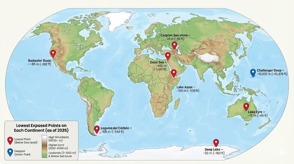
It usually refers to the lowest exposed land on every continent, not ocean trenches. As of 2025, these include the Dead Sea shores in Asia, Lake Assal in Africa, Death Valley’s Badwater Basin in North America, Laguna del Carbón in South America, the Caspian Sea shore in Europe, Lake Eyre in Australia, and Deep Lake in Antarctica.
Deepest vs Lowest: How Geographers Talk About “Depth”
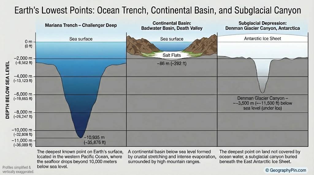
Before we tour each continent, we need to clear up the vocabulary. The deepest place in the world’s oceans is Challenger Deep in the Mariana Trench, around 10,935 meters (about 35,876 feet) below sea level. That’s roughly 6.8 miles (10.9 kilometers) of water above the seafloor.
But continental “deepest points” usually mean the lowest land surface on each continent, measured against sea level. On dry land, the record goes to the shoreline of the Dead Sea basin in Asia, about 430 meters (around 1,410 feet) below sea level, though sources give a range from roughly 413 to 440 meters (1,355–1,444 feet) because the water level keeps dropping.
Antarctica complicates things further. Its lowest exposed land is Deep Lake in the Vestfold Hills, about 50 meters (160 feet) below sea level. Yet if you include landscape under ice, the Bentley Subglacial Trench drops to about 2,540–2,555 meters (8,330–8,382 feet) below sea level without being covered by ocean water.

Three Different “Deepest” Questions
When you see different lists online, they usually answer one of three slightly different questions:
- Deepest ocean point: Challenger Deep in the Mariana Trench, at about 10,935 meters (35,876 feet) below sea level.
- Lowest exposed land point on Earth: the Dead Sea shoreline between Israel, the West Bank, and Jordan, roughly 430 meters (1,410 feet) below sea level.
- Lowest point by continent: the “Seven Lows” list, which names the lowest exposed spot on each of the seven continents.
In this article, we focus on that third question—the lowest exposed point on land by continent—and then explain the massive hidden depressions under ice that many people never hear about.
| Continent | Lowest Exposed Point & Elevation |
|---|---|
| Asia | Dead Sea shoreline, about 430 m (≈1,410 ft) below sea level, fluctuating year to year. |
| Africa | Lake Assal, Djibouti, about 155 m (509 ft) below sea level |
| Europe | Caspian Sea shore in the Caspian Depression, around 28 m (92 ft) below sea level. |
| North America | Badwater Basin, Death Valley, USA, 86 m (282 ft) below sea level. |
| South America | Laguna del Carbón, Argentina, 105 m (344 ft) below sea level. |
| Australia | Kati Thanda–Lake Eyre, Australia, about 15 m (49 ft) below sea level when the lake is dry. |
| Antarctica | Deep Lake, Vestfold Hills, about 50 m (160 ft) below sea level (exposed); Bentley Subglacial Trench is far deeper under the ice. |
The Seven Lowest Exposed Points by Continent
This is the part most readers are really looking for: a continent-by-continent tour of the lowest exposed land. Think of it as the “Seven Summits” challenge flipped upside down—the “Seven Lows.” The elevations below are rounded and can shift slightly over time as water levels and measurement methods improve.
Remember, all of these places sit above continental crust, not in deep ocean trenches. They’re also all reachable by humans with normal expedition gear, though conditions range from hot desert floors to icy coastal hills.
Asia – The Dead Sea, Lower Every Year
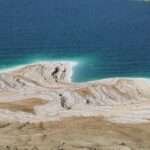
Asia’s lowest point is the shoreline of the Dead Sea basin, shared by Israel, the West Bank, and Jordan. The current elevation is roughly 430 meters (about 1,410 feet) below sea level, with scientific and government sources giving a range between about 413 and 440 meters (1,355–1,444 feet) depending on year and exact measuring spot.
The surprising part: the Dead Sea is dropping by more than 1 meter (over 3 feet) each decade in many recent measurements, because inflow from the Jordan River has been heavily diverted and evaporation is intense. That means “the lowest place on Earth’s land surface” is literally sinking deeper in relative terms as the shoreline retreats.
Africa – Lake Assal, a Super-Salty Crater in Djibouti
Africa’s lowest exposed point is not the famous Danakil Depression in Ethiopia, but nearby Lake Assal in Djibouti. This crater lake sits around 155 meters (509 feet) below sea level in the Afar Triangle, where tectonic plates are slowly pulling apart.
Lake Assal is one of the saltiest bodies of water on Earth and a major source of commercial salt. Standing on its blinding white salt flats feels like walking on a frozen lake, even though daytime air temperatures can easily climb above 104°F (40°C). The contrast between desert hills and bright salt crust makes this one of the most dramatic low spots on the planet.
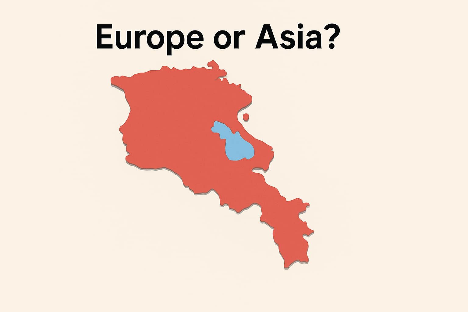
Europe – The Caspian Sea’s Low Shore, Not the Alps
Europe’s lowest point catches many people off guard. It isn’t in a famous valley next to the Alps or the Balkans; it’s the shoreline of the Caspian Sea in the Caspian Depression of Russia and Kazakhstan, about 28 meters (92 feet) below sea level.
The Caspian Sea is technically a lake—an enormous, landlocked, salty basin sitting between Europe and Asia. Different atlases draw the Europe–Asia boundary differently, but many geographic lists treat the northern Caspian shore as Europe’s lowest point. That’s why “deepest points on each continent” articles sometimes disagree on Europe: the answer depends on where you put the border.
North America – Death Valley’s Badwater Basin
North America’s lowest place is Badwater Basin in California’s Death Valley National Park. Its salt flats lie about 86 meters (282 feet) below sea level. On a clear day, you can look up toward Telescope Peak at 3,368 meters (11,043 feet), giving a dramatic vertical contrast in a single view.
Badwater Basin isn’t always bone dry. After rare desert rainstorms, a shallow, temporary lake can spread across the basin, only to evaporate again and leave behind fresh salt polygons. Its depth number has been refined over time, but the consensus remains around 86 meters (282 feet) below sea level.
South America – Laguna del Carbón in Patagonia
In South America, the lowest exposed point is Laguna del Carbón (“Coal Lagoon”) in Argentina’s Santa Cruz Province. This small salt lake sits about 105 meters (344–345 feet) below sea level, inside the larger Gran Bajo de San Julián depression in Patagonia.
Laguna del Carbón is quieter than many other famous lowlands, but it holds several records at once: it is the lowest point in Argentina, in South America, and in the entire Western and Southern Hemispheres. For geography fans, that makes it a kind of “inverse Everest” of the Americas.
Australia – Kati Thanda–Lake Eyre in the Outback
Australia’s lowest point lies in the dry heart of the continent: Kati Thanda–Lake Eyre in South Australia. When the lake bed is exposed, parts of it sit around 15 meters (49 feet) below sea level. In very wet years, floodwaters from far-off rivers can turn it into a large shallow lake again.
Because it fills and dries irregularly, Lake Eyre’s exact minimum elevation can vary slightly with sediment and measurement, but the general figure of around 15 meters (49 feet) below sea level is widely used in geographic “highest and lowest” tables. The huge salt pan is also important for local First Nations cultures and wildlife when the lake floods.
Antarctica – Deep Lake vs the Bentley Subglacial Trench
Antarctica is where the title of this article really earns its “Not What You Think” tag. For exposed land, many lists name Deep Lake in the Vestfold Hills as the continent’s lowest point, about 50 meters (160 feet) below sea level.
However, if we look under the ice sheet, the numbers change dramatically. The Bentley Subglacial Trench reaches roughly 2,540–2,555 meters (about 8,330–8,382 feet) below sea level, all hidden beneath kilometers of ice. That makes it one of the deepest points on Earth’s solid surface not covered by the ocean, a sort of frozen counterpart to ocean trenches like the Mariana.
Hidden Depths: Subglacial Basins and Continental Margins
Once you count land under ice, the picture of “deepest points on each continent” shifts again. West Antarctica is riddled with deep basins like the Bentley Subglacial Trench and the Byrd Subglacial Basin. If the ice magically vanished and the crust slowly flexed back upward, some of these basins would still lie hundreds or even thousands of meters below sea level.
Geophysicists map these hidden landscapes with radar and seismic surveys, then tie them to GPS and satellite data. The result is that our map of Antarctica’s underside is more detailed in 2025 than ever before—but also still evolving. Some recent climate and ice-sheet studies suggest that changes in these deep basins could influence how quickly Antarctic ice flows toward the sea.
Another debate concerns continental margins. Parts of the continental shelf, especially near big ocean trenches, dip far below sea level while still being geologically “continental.” The deepest points in each ocean—like the Puerto Rico Trench in the Atlantic or Horizon Deep in the Tonga Trench—are usually treated separately from continents, even when they sit near continental plates.
FAQ
What is the deepest point on Earth overall?
The deepest known point is Challenger Deep in the Mariana Trench, in the western Pacific Ocean. It plunges to about 10,935 meters (35,876 feet) below sea level as of recent 2020s measurements, making it deeper than Mount Everest is tall.
What is the lowest exposed land point on Earth?
The lowest exposed land point is the shoreline of the Dead Sea basin between Israel, the West Bank, and Jordan, roughly 430 meters (about 1,410 feet) below sea level. The exact number changes because the Dead Sea is shrinking due to reduced river inflow and high evaporation.
Why do different sources list different depths for these places?
There are three main reasons: water levels rise or fall from year to year, measurement methods improve over time, and different agencies choose slightly different reference points. For example, Dead Sea and Lake Assal elevations vary by several meters (or tens of feet) between older and newer data.
Can tourists visit the deepest points on each continent?
Most of the “Seven Lows” are accessible with planning: you can drive to Death Valley’s Badwater Basin, float in the Dead Sea, or visit Lake Assal and Lake Eyre with local guides. Laguna del Carbón and Deep Lake require more logistics and are usually visited on specialist tours or research trips rather than casual day trips.
Are any of these lowest points in danger from climate or human activity?
Yes. The Dead Sea’s level is dropping fast because rivers are diverted and minerals are extracted. Some lowland depressions also face pollution or infrastructure pressure. In Antarctica, the concern is different: changes in subglacial basins could alter how quickly ice flows toward the ocean, affecting global sea-level rise.
What Did We Learn Today?
- “Deepest” can mean ocean trenches, exposed land, or land buried under ice, and each gives a different list of extremes.
- The Dead Sea shoreline in Asia is Earth’s lowest exposed land, while Challenger Deep holds the overall depth record underwater.
- Every continent has its own low point, from Lake Assal in Africa to Death Valley in North America and Laguna del Carbón in South America.
- Antarctica hides enormous subglacial trenches like the Bentley Subglacial Trench, far deeper than its exposed coastal depressions.
- These extremes are not fixed; water levels, climate, and better measurements keep updating the numbers as of 2025.