Ottawa is Canada’s capital city, chosen by Queen Victoria on 31 December 1857 for its defensible location and position between English-speaking Ontario and French-speaking Québec. Today it anchors the Ottawa–Gatineau metropolitan area and the National Capital Region, home to Parliament Hill and the UNESCO-listed Rideau Canal.
What and where is Ottawa?
Ottawa sits in eastern Ontario at the confluence of the Ottawa and Rideau rivers, directly across from Gatineau, Québec. Together they form the Ottawa–Gatineau Census Metropolitan Area (CMA) and the legally defined National Capital Region (NCR). The city’s compact downtown clusters around Parliament Hill, while suburbs stretch along the Greenbelt and into both provinces.
As of the 2021 Census, the City of Ottawa had 1,017,449 residents; the wider CMA registered 1,488,307, making it Canada’s fourth-largest metro area. These figures come from Statistics Canada and are the most comparable across cities; more recent 2024 estimates show continued growth, driven largely by immigration to major metropolitan areas.
Quick orientation
Downtown Ottawa lies near 45.4215° N, 75.6972° W at roughly 230 ft (70 m) above sea level. The city center is roughly 124 mi (200 km) from Montréal and about 280 mi (450 km) from Toronto by road. The Ottawa and Rideau waterways shaped the settlement, with the Rideau Canal linking the Ottawa River to Lake Ontario at Kingston.
| Metric | Value |
|---|---|
| Capital since | 31 December 1857 (Queen Victoria’s selection) |
| City population (2021) | 1,017,449 (Statistics Canada) |
| Metro population (2021, CMA) | 1,488,307 (Statistics Canada) |
| City land area | ≈2,788 km² (≈1,076 sq mi) (2021 data) |
| National Capital Region (NCR) | ≈4,715 km² (≈1,821 sq mi) spanning Ontario & Québec |
| Rideau Canal length | 202 km (126 mi), UNESCO World Heritage (2007) |
| Coordinates (approx.) | 45.4215° N, 75.6972° W |
How and why Ottawa became Canada’s capital (1857–1867)
Before Ottawa, legislators shuttled between Kingston, Montréal, Toronto, and Québec City, sparking years of rivalry. In 1857, the Province of Canada asked Queen Victoria to choose a permanent seat. On 31 December 1857, she selected Ottawa—remote enough to be defensible (especially after the War of 1812), yet positioned between Canada West (Ontario) and Canada East (Québec), a political compromise between English and French Canada.
Construction of Parliament Buildings began in 1859. By 1866, legislators held sessions in Ottawa’s new Centre, East, and West Blocks. One year later, on 1 July 1867, the Dominion of Canada was born, and Ottawa continued as the national capital. Local archives document how Bytown (founded 1826) became Ottawa (incorporated 1855) and how the decision was communicated by Colonial Secretary Henry Labouchere’s letter of 31 December 1857. City of Ottawa Archives (PDF);
Queen Victoria’s decision
The choice balanced strategy and unity: Ottawa’s inland, cliff-top setting was easier to defend than border cities, and its location on the Ontario–Québec line symbolized a bilingual, bicultural state. Water routes via the Ottawa River and the Rideau Canal also linked it to Montréal and Kingston.
Government, language, and the National Capital Region
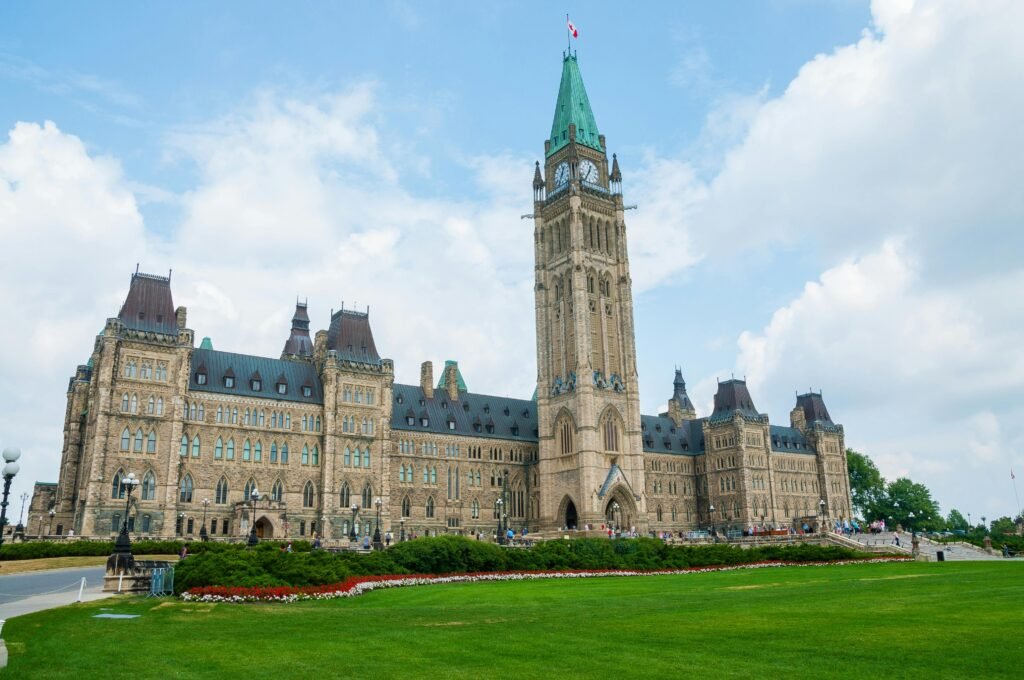
Parliament Hill—overlooking the Ottawa River—is the symbolic heart of Canada’s democracy. The Hill houses the Senate and House of Commons in Gothic Revival buildings on landscaped grounds. It remains the site of national ceremonies, Canada Day events, and public gatherings, and it’s administered in part by the National Capital Commission (NCC).
Ottawa also embodies Canada’s bilingual identity. While Canada’s official languages are English and French, the municipality has its own bilingualism by-law that guarantees city services in both languages, reaffirmed by provincial legislation. Street signs, transit information, and City Hall services are routinely available in English and French.
Geography, culture, and landmarks you’ll recognize
Ottawa’s setting defines its look and lifestyle. The Rideau Canal threads through downtown, passing beneath Parliament before descending a dramatic flight of locks to the Ottawa River. In summer it’s a boating route; in winter (weather permitting) a vast urban skating rink. The canal—engineered in the 1820s–1830s for military strategy—was inscribed as a UNESCO World Heritage Site in 2007 for its outstanding preservation.
Cultural institutions span both banks: national galleries and museums, the National Arts Centre, and the Canadian Museum of History (in Gatineau). Neighborhoods like the ByWard Market mix food halls, artisan shops, and nightlife within walking distance of the Hill. Four distinct seasons shape the calendar—spring tulips, hot summers, bright foliage, and snowy winters with festivals such as Winterlude.
Rideau Canal in focus
The canal runs 202 km (126 mi) from Ottawa to Kingston, with 47 locks and historic lockstations still in use. Parks Canada maintains the waterway and its heritage structures.
Visiting essentials (what to see in a day)
Start on Parliament Hill for the views and a guided visit (advance bookings are recommended during renovations). Walk to the canal’s Ottawa Locks and the Château Laurier, then loop through the ByWard Market for lunch. In the afternoon, choose a museum (art, history, nature, or aviation) and, time permitting, cross the Alexandra Bridge to Gatineau for panoramic river vistas. In winter, check if the Rideau Canal Skateway is open and rent skates for a classic Ottawa experience.
FAQ
Is Ottawa in Ontario or Québec?
Ottawa is in Ontario, on the south bank of the Ottawa River. Gatineau, directly across the river in Québec, and Ottawa together form the Ottawa–Gatineau CMA and the National Capital Region that spans both provinces.
Why was Ottawa chosen as Canada’s capital?
In 1857 Queen Victoria selected Ottawa for its defensible inland position and its location between Canada West (Ontario) and Canada East (Québec), a political compromise. The decision was formally relayed on 31 December 1857.
How big is Ottawa’s population?
As of the 2021 Census, the City of Ottawa had 1,017,449 residents; the Ottawa–Gatineau CMA had 1,488,307. Statistics Canada’s 2024 estimates indicate ongoing growth in large metropolitan areas.
What Did We Learn Today?
- Ottawa has been Canada’s capital since 31 December 1857, chosen by Queen Victoria.
- The city anchors a binational metro across Ontario and Québec, with 1.49 million people (2021 CMA).
- Parliament Hill is the symbolic heart of Canadian democracy.
- The Rideau Canal is a 202 km (126 mi) UNESCO World Heritage route through downtown.
- Ottawa’s bilingual services reflect Canada’s English–French identity at the municipal level.