Brazil’s major cities tell very different stories. São Paulo is the country’s largest city; Rio de Janeiro brings mountains and beaches into its urban landscape; Brasília is the national capital; and Salvador, Fortaleza, Belo Horizonte and Manaus reveal other sides of Brazilian culture, history and geography.
This guide follows seven major cities from the Atlantic coast to the inland plateau and the Amazon basin. The population comparison uses a single reference date, 1 July 2026, while the city profiles explain what makes each place distinctive.
São Paulo and Rio de Janeiro are Brazil’s two most populous cities. Brasília is the capital, while Fortaleza, Salvador, Belo Horizonte and Manaus are also major urban centres with more than two million residents in the 2026 IBGE estimates.
Read the boundary correctly: the figures below describe municipalities, except Brasília, whose published total covers the Federal District. They are not metropolitan-area populations.
Population and Geography
Population depends on where a boundary is drawn. A municipality is an administrative territory and can include both urban and rural land; a metropolitan region includes several connected municipalities. Comparing one city’s municipality with another city’s entire metro area gives a misleading result.
On a small screen, scroll the table sideways to see every column.
| City | State or district | Region | Estimated residents |
|---|---|---|---|
| São Paulo | São Paulo (SP) | Southeast | 11,911,337 |
| Rio de Janeiro | Rio de Janeiro (RJ) | Southeast | 6,731,133 |
| Brasília* | Federal District (DF) | Central-West | 3,009,996 |
| Fortaleza | Ceará (CE) | Northeast | 2,582,360 |
| Salvador | Bahia (BA) | Northeast | 2,559,945 |
| Belo Horizonte | Minas Gerais (MG) | Southeast | 2,415,451 |
| Manaus | Amazonas (AM) | North | 2,327,101 |
*Brasília: the 3,009,996 figure covers the whole Federal District, not just the planned central area known as the Plano Piloto. The Federal District is not divided into municipalities; its administrative regions should not be treated as separate municipalities in this comparison.
Source: IBGE 2026 population estimates, revised file dated 29 October 2026. These are estimates, not a new census. The table is ordered by population.
São Paulo: Brazil’s Largest City

São Paulo is the capital of the state of the same name and a major centre for business, culture and everyday urban life. It is inland rather than a seaside city, so its appeal is quite different from the beach-focused image often associated with Brazil.
The city’s conventional founding date is 25 January 1554, when Jesuits established a college at the site now known as Pateo do Collegio. The municipal council’s historical account traces this early settlement and its later development into a city. Today, historic buildings sit alongside dense commercial districts and modern towers.
For visitors, museums and parks provide useful starting points. Visite São Paulo’s attraction guide highlights the Museu de Arte de São Paulo (MASP) on Avenida Paulista and Ibirapuera Park, a large green and cultural space opened in 1954. Together, they show how art, architecture and public space contribute to the city’s identity.
What makes it distinctive: São Paulo offers a view of metropolitan Brazil through its cultural institutions, neighbourhoods and commercial life, rather than a single landmark or coastline. Its size also makes it worth planning visits by area instead of assuming attractions are close together.
Rio de Janeiro: The Marvelous City

Rio de Janeiro is Brazil’s second most populous city and the capital of Rio de Janeiro state. It was the national capital from 1763 until 1960, when the federal government moved to Brasília, a transition outlined by Brazil’s Chamber of Deputies.
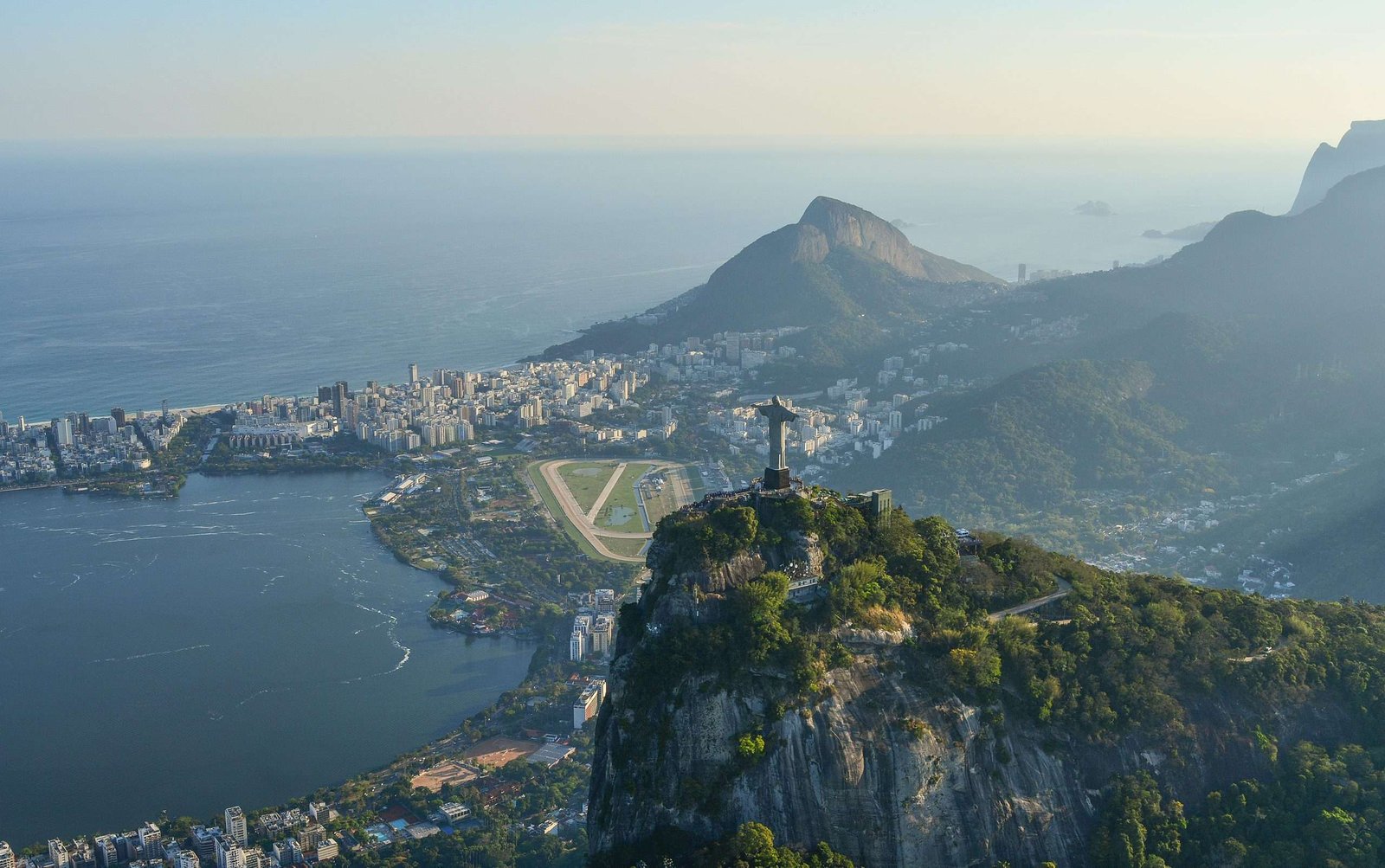
Rio’s landscape is central to its identity. Forested hills, Guanabara Bay and the Atlantic shore frame neighbourhoods and transport corridors. Christ the Redeemer stands on Corcovado, while Sugarloaf rises near the entrance to the bay. Copacabana’s waterfront is another instantly recognisable part of the city.
The UNESCO-listed Carioca Landscapes between the Mountain and the Sea, inscribed in 2012, recognise the relationship between these natural features and designed urban spaces. The listed landscape includes elements such as Tijuca National Park, the Botanical Gardens and the Copacabana waterfront; it is not a blanket designation of the entire municipality.
What makes it distinctive: the close relationship between city, mountains and sea.
Brasília: The Planned National Capital

Brasília became Brazil’s capital on 21 April 1960. Its construction under President Juscelino Kubitschek was part of a wider effort to move the national government inland. The Federal District’s historical atlas explains the project’s links to territorial integration and inland development.
Urban planner Lúcio Costa designed the Plano Piloto, and Oscar Niemeyer designed many of its major public buildings. The intersecting axes, government buildings and residential superblocks make the capital a distinctive example of twentieth-century planning. National Congress and the Cathedral are among its best-known architectural landmarks.
Brasília entered the UNESCO World Heritage List in 1987. The official World Heritage description explains the relationship between Costa’s plan, Niemeyer’s buildings and the superquadras. Six-storey housing blocks are one of the characteristic features of the planned superquadras.
What makes it distinctive: Brasília is both a working national capital and a landmark of modernist urbanism. Its population total includes administrative regions well beyond the monumental centre. Visiting the Plano Piloto therefore reveals only one part of the wider capital region.
Salvador: Afro-Brazilian Culture and Colonial History

Salvador, the capital of Bahia, was Brazil’s first colonial capital, from 1549 to 1763. Its location between Todos os Santos Bay and the Atlantic helped make it an important port. Colonial prosperity was deeply connected to sugar production and the forced labour and trafficking of enslaved Africans.
The Historic Centre of Salvador de Bahia, inscribed by UNESCO in 1985, includes Pelourinho and other historic districts. Churches, public squares and colourful houses survive within a landscape divided between an upper city on the escarpment and a lower city beside the port. The Lacerda Elevator is a familiar connection between these levels.
Afro-Brazilian heritage is a living part of Salvador, not simply a backdrop for visitors. One example is the Ofício das Baianas de Acarajé, recognised by Brazil’s heritage institute, IPHAN. The women who practise this food tradition preserve knowledge, religious connections and livelihoods as well as a well-known dish.
What makes it distinctive: Salvador brings together coastal geography, colonial architecture and enduring Afro-Brazilian cultural traditions. Its historic buildings are best understood alongside the people and difficult histories that shaped them.
Fortaleza: Coastal Life and Ceará’s Culture

Fortaleza is Ceará’s capital on Brazil’s northeastern Atlantic coast. It combines a large urban economy with a prominent beach and cultural identity. In the consistent 2026 population comparison above, its municipality has more residents than Salvador’s.
The official Fortaleza tourism website highlights Praia de Iracema and Praia do Futuro among the city’s coastal attractions. These are different parts of a working metropolis, not a single resort strip. The city also offers opportunities to explore Ceará’s arts and performance traditions beyond the waterfront.
A particularly useful cultural landmark is the Theatro José de Alencar. The institution’s operator describes it as an active centre for the arts as well as an architectural heritage site. Its continued cultural use is as important to understanding the city as its appearance.
What makes it distinctive: the combination of Atlantic beaches and Ceará’s urban cultural life. For a beach visit, check current local swimming-water advice rather than assuming every stretch is always suitable: Ceará’s environmental authority publishes regular bathing-water bulletins, and conditions change.
Belo Horizonte: A Planned City and Modernist Landmarks

Belo Horizonte, the capital of Minas Gerais, was inaugurated in 1897 as a planned capital. Its broad avenues, squares and cultural institutions offer a different urban setting from Brazil’s coastal cities. The Brazilian government’s city profile highlights its planned layout, economic role and cultural attractions.
Pampulha is especially important to the city’s architectural history. Developed around an artificial lake, the modernist ensemble includes the São Francisco de Assis church, the former casino, Casa do Baile and the yacht club. Oscar Niemeyer worked with artists and other specialists, while Roberto Burle Marx contributed landscape design.
The Pampulha Modern Ensemble became a UNESCO World Heritage Site in 2016. These buildings form a group around the lake, combining architecture, landscaping and art.
Beyond architecture, the Mercado Central introduces visitors to regional foods and crafts, while the Circuito Liberdade brings cultural attractions together around Praça da Liberdade.
What makes it distinctive: planned urban history, modernist design and the food culture of Minas Gerais come together within the same city.
Manaus: An Amazonian Metropolis

Manaus is the capital of Amazonas, a large urban centre on the Rio Negro within the Amazon basin. It is both a destination in its own right and a starting point for river travel. Its substantial population, industries and long urban history are important parts of the Amazon’s human geography.
Nearby, the dark Rio Negro meets the sediment-rich Solimões at the Meeting of the Waters. Manaus’s official tourism guide describes this confluence and the boat journeys used to see it. In Brazilian geographical usage, the river downstream of this meeting is called the Amazonas.
The rubber boom left a strong mark on the city’s built heritage. The Teatro Amazonas opened in 1896 and remains a major cultural landmark. IPHAN’s account of Manaus’s historic centre connects its architecture with the wealth and transformation of that period.
Modern Manaus also has an industrial identity. The Manaus Free Trade Zone was created in 1957 and restructured in 1967, with the establishment of Suframa. The agency’s official history explains this development, which is distinct from the earlier rubber economy.
What makes it distinctive: Manaus brings Amazonian river geography, historic architecture and contemporary industry into the same urban story. Exploring its heritage before travelling farther along the rivers gives a fuller picture of the region.
Frequently Asked Questions
What is the largest city in Brazil?
São Paulo is the largest by municipal population, with an estimated 11,911,337 residents on 1 July 2026. Its wider metropolitan region is a different geographical unit and has a larger population.
Is Rio de Janeiro the capital of Brazil?
No. Brasília has been the national capital since 21 April 1960. Rio de Janeiro was the capital before that and is now the capital of Rio de Janeiro state.
Why does Brasília’s population need a special note?
IBGE’s Brasília total covers the whole Federal District, including administrative regions outside the Plano Piloto. It does not count only the planned central city.
Are all of Brazil’s major cities on the coast?
No. Rio, Salvador and Fortaleza are coastal, but São Paulo, Brasília and Belo Horizonte are inland. Manaus is an inland river city in the Amazon basin.
Are these population figures from the 2022 census?
No. They are IBGE estimates for 1 July 2026. Census counts and later estimates have different reference dates and should not be mixed in the same comparison without explanation.
What Did We Learn Today?
Brazil’s major cities cannot be understood through population alone. São Paulo’s scale, Rio’s coastal landscape, Brasília’s planned capital, Salvador’s living heritage, Fortaleza’s beaches and arts, Belo Horizonte’s modernism and Manaus’s river setting each reveal a different part of the country.
We also learned why boundaries matter: a municipality, a metropolitan region and Brasília’s Federal District are not interchangeable. Using one dated source makes the population comparison clearer, while history and geography explain what the numbers cannot.
Sources & Data Notes
Checked November 9, 2026.
Population reference: all city population figures use IBGE estimates for 1 July 2026, from the official revised municipal tables dated 29 October 2026. No 2018 estimates or 2022 census counts are mixed into the table. Brasília’s figure represents the Federal District.
- IBGE population-estimates programme: reference dates, methodology and releases.
- UNESCO World Heritage records: Rio’s Carioca landscapes, Brasília, Salvador’s historic centre and Pampulha.
- City history, heritage and visitor information are linked within each profile, using municipal, federal, heritage-institution and official tourism sources.
Editorial scope: this is a guide to seven major cities, not a complete inventory of Brazil’s important urban centres. Population estimates can be revised. Attraction access, transport arrangements and beach conditions should be checked with the relevant local authority before a visit.