The Volga flows through European Russia from the Valdai Hills to the Caspian Sea. About 2,193 miles (3,530 kilometers) long, it is Europe’s longest river. The Oka and Kama feed its course, reservoirs reshape many reaches, and its lower river divides into delta channels before entering an inland sea with no natural ocean outlet.
How to use this article: Trace the course, understand tributary connections, and explore the Caspian destination.
1. Trace the Volga from the Valdai Hills to the Caspian
A river that bends before turning south
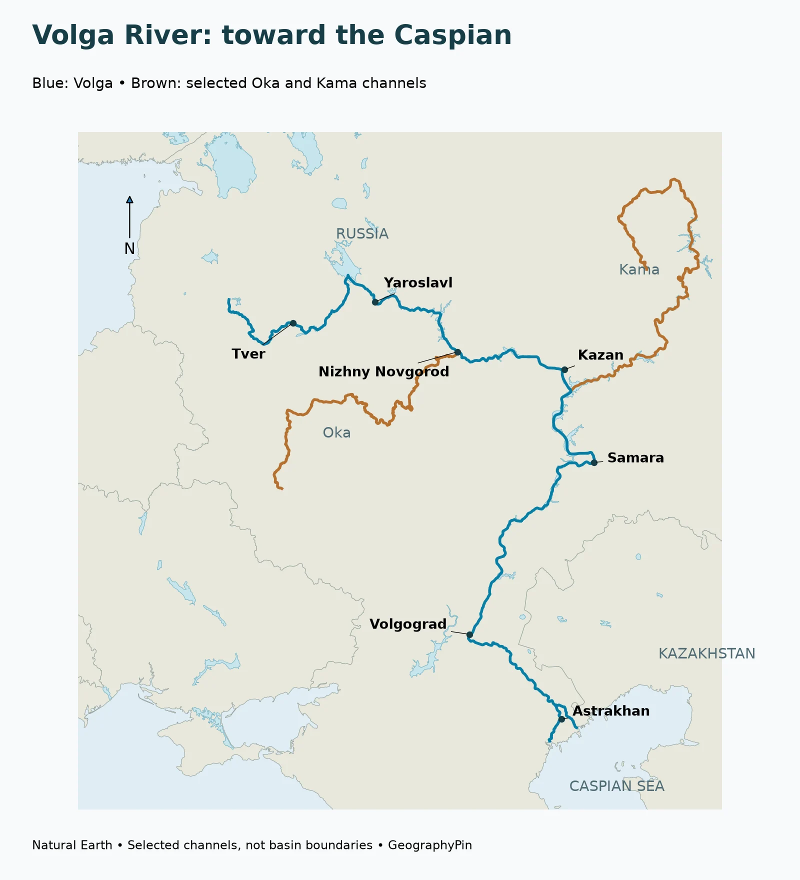
The Volga does not follow a straight north–south line. Its headwaters lie in the Valdai Hills northwest of Moscow, and its upper course leads through a lake-rich landscape toward Tver and the Rybinsk area. Farther downstream, Yaroslavl and Nizhny Novgorod provide useful reference points along the broad eastward sweep.
Near Kazan, the river system is joined by the Kama. The Volga then continues generally southward, passing the Samara region and eventually Volgograd. Astrakhan lies near the lower river’s delta landscape, where the single-line appearance of a small-scale map gives way to a branching water network.
Length describes the river, not a journey across the map
A commonly cited length is about 2,193 miles (3,530 kilometers), used in the study-area description of Safarov and colleagues’ 2024 hydrological paper. It measures the river’s course rather than the straight-line distance between source and mouth.
The value is best treated as a rounded reference. River measurements depend on the selected headwater, channel detail and treatment of impounded reaches.
The mapped course and its selected tributaries make a practical route for learning the geography: first locate Tver and Yaroslavl, then the Oka junction, then Kazan and the Kama connection, and finally follow the river south toward the Caspian. The city labels are orientation points, not claims that the channel passes through each city’s geometric center.
2. Understand the Oka and Kama connections
The Oka links the western basin to Nizhny Novgorod
The Oka joins the Volga at Nizhny Novgorod. It collects water from a large area west of the middle Volga, giving the junction a significance beyond the meeting of two visible channels.
The Moskva River is a tributary of the Oka. That relationship explains how Moscow belongs to the Volga drainage system without the Volga itself flowing through Moscow. The natural downstream sequence is Moskva → Oka → Volga → Caspian Sea. Membership in a river basin does not require a city to stand on the basin’s namesake river.
The Kama brings in the northeastern network
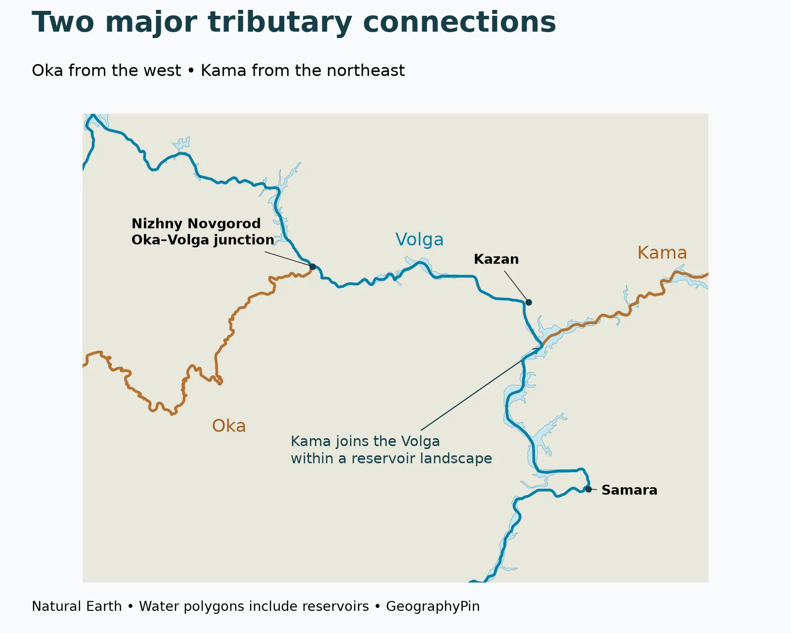
The Kama joins the Volga downstream of Kazan, within the broad water landscape of the Kuybyshev reservoir. It drains a large northeastern part of the system, with tributaries reaching toward the Urals.
The map below highlights the two connections. Brown lines identify selected tributaries; blue follows the Volga. Broad pale-blue water areas show why a modern confluence can look quite different from a simple Y-shaped meeting of narrow rivers.
Main river, tributary and basin are different things
The mainstem is the river conventionally called the Volga. A tributary joins it, directly or through another river. The basin is the land area whose drainage reaches that network.
That distinction matters at the Kama junction, where the size of a tributary can make a naming convention seem counterintuitive. A large contributing river does not automatically replace the established downstream name. Trace the actual connection before assuming that the widest-looking arm on a reservoir map determines the river’s name.
3. Reservoirs are part of the modern Volga landscape
Why the river sometimes looks like a chain of lakes
Several reaches of the Volga have been impounded, creating broad reservoirs along a connected river course. Rybinsk, Kuybyshev, Saratov and Volgograd are important names in this transformed landscape. A reservoir is not a separate drainage destination: water continues through the regulated system toward the lower Volga.
These water bodies help explain the alternating narrow and broad shapes visible on maps. A river centerline can continue through a reservoir, while the surrounding water polygon marks its mapped surface. The line and the polygon describe different aspects of the same connected system.
Reservoirs serve multiple purposes, including hydropower, navigation and water supply. They also affect when water moves downstream. The 2024 hydrological study emphasizes changes to the seasonal distribution of runoff and the spring flood, rather than treating regulation as a simple switch that removes every flood or fixes one flow rate forever.
Snowmelt and regulation act together
Snowmelt and precipitation across the basin supply the river. Reservoir operations then modify part of the seasonal movement of that water. The result is a river that remains connected to climate and weather while also being strongly shaped by infrastructure.
A discharge measurement applies to its gauge and period; neither a spring observation nor a historical annual average automatically describes present conditions along the whole river.
4. The lower Volga, delta and Caspian Sea
Branching channels are not incoming tributaries
Downstream of Volgograd, the Akhtuba branches from the Volga and runs alongside it through the lower floodplain system. This is a distributary relationship: water leaves the principal channel into another branch. It is the opposite direction of connection from a tributary such as the Oka, which brings water into the Volga.
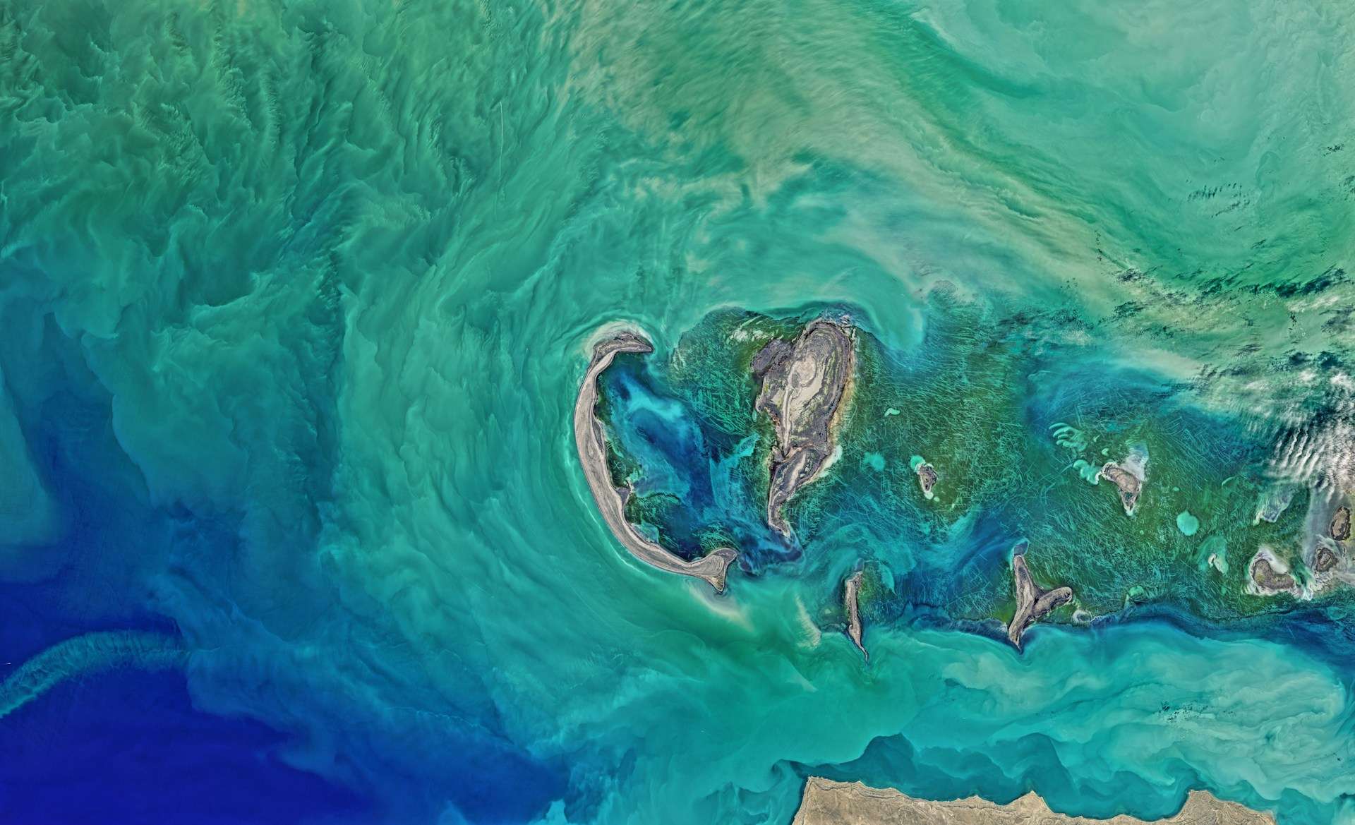
Closer to the Caspian, the delta contains numerous channels, wetlands and islands. Astrakhan is a useful city reference for this lower-river landscape, but a city dot cannot represent the full delta. Nor does a single blue line on the overview show every distributary or wetland passage.
This branching geography matters ecologically as well as cartographically. Water and sediment do not arrive at the receiving basin through one simple pipe. They move through a changing network whose shape reflects river processes, vegetation and the level of the Caspian.
An inland destination with no natural ocean outlet
The Volga ends in the Caspian Sea, not the Black Sea. Despite its name, the Caspian is an enclosed inland water body. It has no natural river outlet carrying its water onward to the world ocean.
Water entering this closed system is balanced principally against losses through evaporation. The Volga is its dominant river inflow, but the sea’s level also depends on conditions over the Caspian itself. It would be misleading to explain every shoreline change using one river-flow number alone.
For the receiving basin, see GeographyPin’s Caspian Sea guide. For the continental comparison, the physical map of Europe places the Volga beside rivers with different outlets, including the Rhine and Danube.
5. Read the Volga map without mixing up waterways
A canal connection is not the river’s natural mouth
The Volga–Don Canal links the Volga and Don systems for navigation. The Don leads toward the Sea of Azov, which is connected to the Black Sea. This engineered waterway connection does not mean that the Volga naturally empties into the Black Sea.
A drainage map and a navigation map answer different questions. One follows the natural receiving basin; the other can include canals, locks and managed links crossing drainage divides. The distinction allows both statements to be true: the Volga drains to the Caspian, and inland waterways connect its system to other seas.
Use junctions as anchors rather than rigid section boundaries
Descriptions often divide the river into Upper, Middle and Lower Volga. The Oka and Kama junctions are useful anchors for this division, but references do not always put every section boundary in the same place. Some ecological descriptions use reservoir-related boundaries instead.
For learning the course, the connections are more important than forcing every source into one subdivision. Follow the Valdai headwaters, Oka junction, Kama junction and lower delta in that order. Then add the reservoirs and cities as separate layers of information.
| Feature | Relationship to the Volga | Map-reading clue |
|---|---|---|
| Oka | Tributary joining at Nizhny Novgorod | Water enters from the western network |
| Kama | Major tributary joining downstream of Kazan | Northeastern drainage meets the Volga in a reservoir landscape |
| Akhtuba | Lower-river distributary | Water branches away from the main channel |
| Caspian Sea | Inland receiving water body | The river’s natural downstream destination |
| Volga–Don Canal | Engineered navigation connection | A link between river systems, not a new natural outlet |
Frequently Asked Questions
Where does the Volga River start and end?
It begins in the Valdai Hills of European Russia and ends in the Caspian Sea through its lower delta.
How long is the Volga?
A commonly cited rounded length is about 2,193 miles (3,530 kilometers). It is Europe’s longest river.
Does the Volga flow through Moscow?
No. Moscow lies on the Moskva River, which flows into the Oka, a tributary of the Volga. The city belongs to the drainage network without being on the Volga mainstem.
Does the Volga empty into the Black Sea?
No. Its natural destination is the Caspian Sea. The Volga–Don Canal is an engineered navigation connection to a different river system.
What are the Oka and Kama?
They are major tributaries of the Volga. The Oka joins at Nizhny Novgorod; the Kama joins downstream of Kazan.
What Did We Learn Today?
The Volga connects the Valdai headwaters, major tributary networks and a heavily regulated river corridor with the Caspian Sea. The Oka and Kama bring water into the system, while the Akhtuba branches away downstream. Reservoirs and canals shape how the river is used, but its natural destination remains an enclosed inland sea rather than the world ocean.
Sources & Data Notes
- Safarov, Safarov and Bayramov (2024), Water: study-area length, runoff sources, reservoir regulation and Caspian water balance. This profile does not present the paper’s historical flow series as current measurements.
- Freshwater Ecoregions of the World: Volga–Ural: Oka/Moskva relationship, Kama connection, reservoirs and differing section conventions. The ecoregion includes more than the Volga basin and is not used as a basin boundary.
- UNEP/GRID: Freshwater in Europe: Volga chapter for Valdai origin, lower-river distributaries and Don chapter for canal connection. Historical population, economic and shoreline-height figures are not used.
- NASA: Volga River flows into the Caspian Sea: European river and receiving-basin context.
- Natural Earth public-domain data: selected river centerlines, countries, lakes and settlement locators.
Cartographic method: GeographyPin maps use actual Natural Earth 1:10m geometry, displayed in a Lambert azimuthal equal-area projection centered at 53°N, 44°E. Equal map aspect is preserved. Blue selects Volga centerlines and brown selects the European Oka and Kama; a different Oka in Siberia is excluded. Water polygons include mapped reservoirs and the Caspian. No basin outline, current inundation surface, dam-operation status or exhaustive delta-channel network is inferred. The overview’s upstream line endpoint is generalized, not a surveyed spring.
Numbers: The approximate 3,530-kilometer length converts to about 2,193 miles. No modern discharge, current Caspian elevation or exact delta-area claim is made. River-section names differ among references, so junctions are used as geographic anchors rather than universal boundaries.