A lake in the California desert can have a history shaped by both river floods and irrigation. The Salton Sea is a useful example: understanding its map requires separating the basin, the modern lake, and the much older lakes that once occupied the region.
The Salton Sea is a saline, terminal lake in southeastern California. Its modern formation dates to Colorado River flooding in 1905–1907, but earlier Lake Cahuilla phases occupied the basin long before that. Agricultural drainage has helped sustain it; reduced inflows and evaporation contribute to shrinking water coverage and increasing salinity.
How to use this article: Start with the watershed map, compare the lake’s separate historical chapters, or see what habitat projects actually build.
1. Where the Salton Sea is and what its watershed means
The Salton Sea occupies a below-sea-level basin in southeastern California, in Imperial and Riverside counties. The lake and its watershed are not the same area: the water body is in California, while the drainage region extends into Baja California, Mexico. USGS describes a watershed covering more than 8,000 square miles (about 20,700 square kilometers).
Reading the watershed map
The outline shows the land drainage unit surrounding the lake, not the former extent of Lake Cahuilla, a restoration project boundary, or a prediction of future flooding. The blue lake shape is reference hydrographic geometry, not a dated survey of today’s shoreline. It should not be used to measure today’s exposed lakebed.
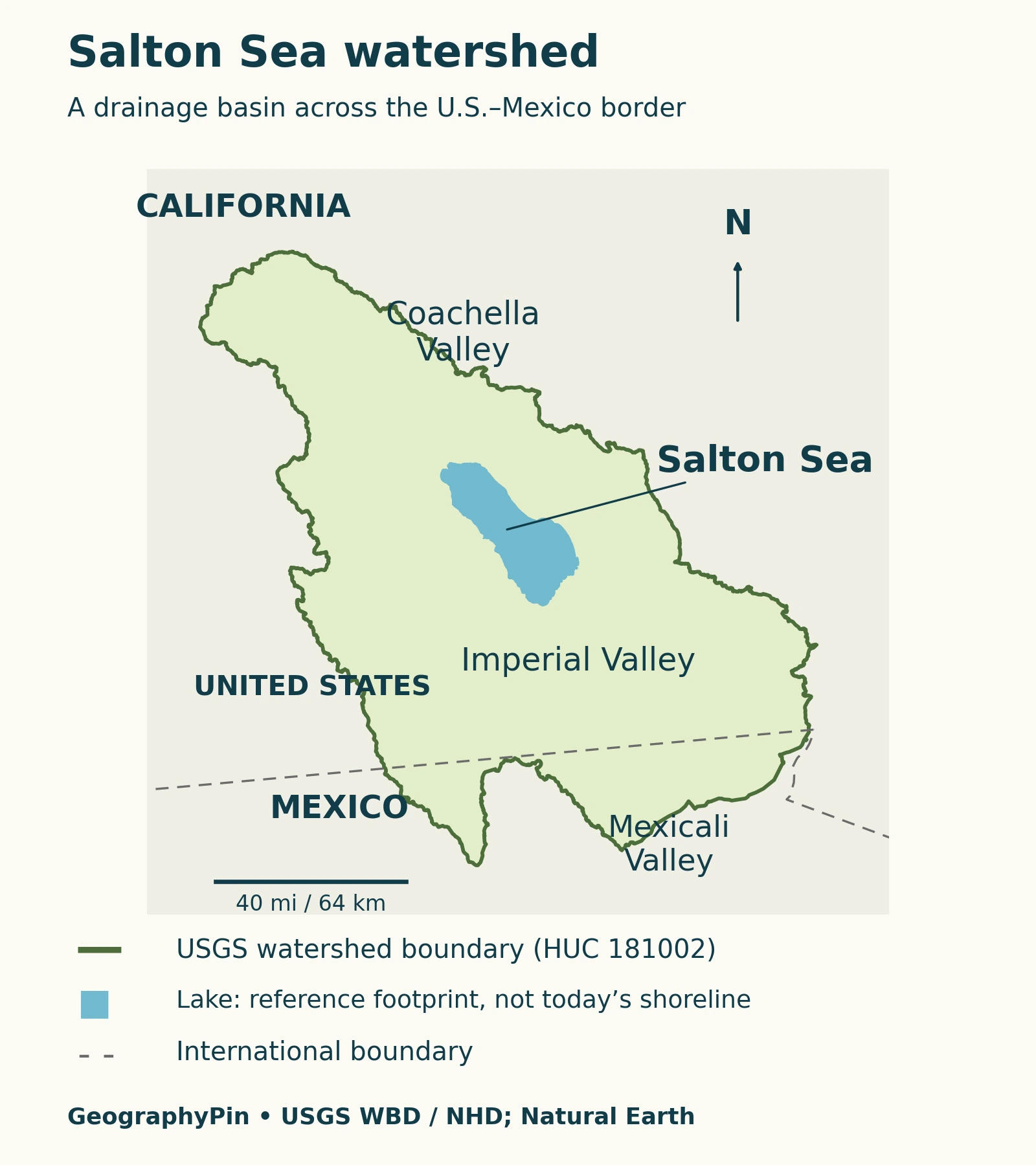
Start with the national border, then locate the lake north of it. This makes an important distinction visible: a river can cross the border on its way to a lake that does not cross the border itself. The map also separates the broad drainage setting from the much smaller water surface.
Watershed outlines alone do not explain every water supply connection. Imported irrigation water adds a human-managed link to the Colorado River system. A map of topographic drainage and a diagram of water deliveries therefore answer different questions. USGS: Water Availability in the Salton Sea Watershed provides the regional study context.
2. Lake Cahuilla and the modern lake are different chapters
The 1905 flood did not create the basin or put water there for the first time. Earlier Colorado River diversions into this low-lying region had produced lakes that later receded. Lake Cahuilla is the name associated with the much older lake history.
A chronology without confusing the lakes
| Period | What happened | What it does not mean |
|---|---|---|
| Before 1905 | Lake Cahuilla repeatedly filled and receded in the Salton Trough. | The basin was not continuously occupied by one unchanged lake. |
| 1905–1907 | Colorado River floodwater escaped irrigation works and entered the basin. | This was the modern lake’s major formation episode, not the beginning of the basin’s lake history. |
| 1907 | Engineers brought the river back under control. | The modern lake did not immediately disappear. |
| Following decades | Agricultural drainage helped maintain the lake. | Its continued existence did not depend on the 1905 breach remaining open. |
USGS traces the modern episode to irrigation diversions begun in 1901, followed by the loss of control during flooding in 1905. The distinction between the flood and the continuing inflows matters: they explain different parts of the lake’s history. USGS Earthshots: The Lake’s Formation documents that sequence.
A 2022 study reconstructed seven earlier Lake Cahuilla highstands using radiocarbon evidence and historical constraints. Its published age window for the most recent highstand is 1720–1733 CE. That is an allowable timing range, not proof that the lake stayed full throughout every year in it.
Highstands describe periods when water reached a high level. They are not identical to the entire life of a lake, including its filling and drying. The researchers explicitly caution that some age windows include possible dry intervals. Rockwell and colleagues (2022): Lake Cahuilla chronology explains the chronology and uncertainty.
3. Why the Salton Sea is salty and shrinking
A terminal lake has no surface outflow. Water can evaporate while dissolved salts remain behind. Continued inflows bring additional dissolved material, so the balance of water and salt changes together rather than independently.
This explains why a lake formed largely from river water can become much saltier. Evaporation removes water, not a matching share of its dissolved salt. The USGS (2013): Ecosystem Monitoring and Assessment Plan identifies low freshwater inputs and evaporation as major parts of that process.
Why salinity figures need dates
California’s April 2026 State Water Board report describes the Salton Sea as more than twice as salty as the Pacific Ocean. That is a dated broad comparison, not an exact salinity measurement for every location or season. A precise figure needs a sampling date, location, and stated unit.
Do not interchange grams per liter with a percentage without checking the measurement definition and water density. Nor should an older salinity number be presented as a permanent characteristic of a shrinking lake. The date is part of the fact, not an optional footnote.
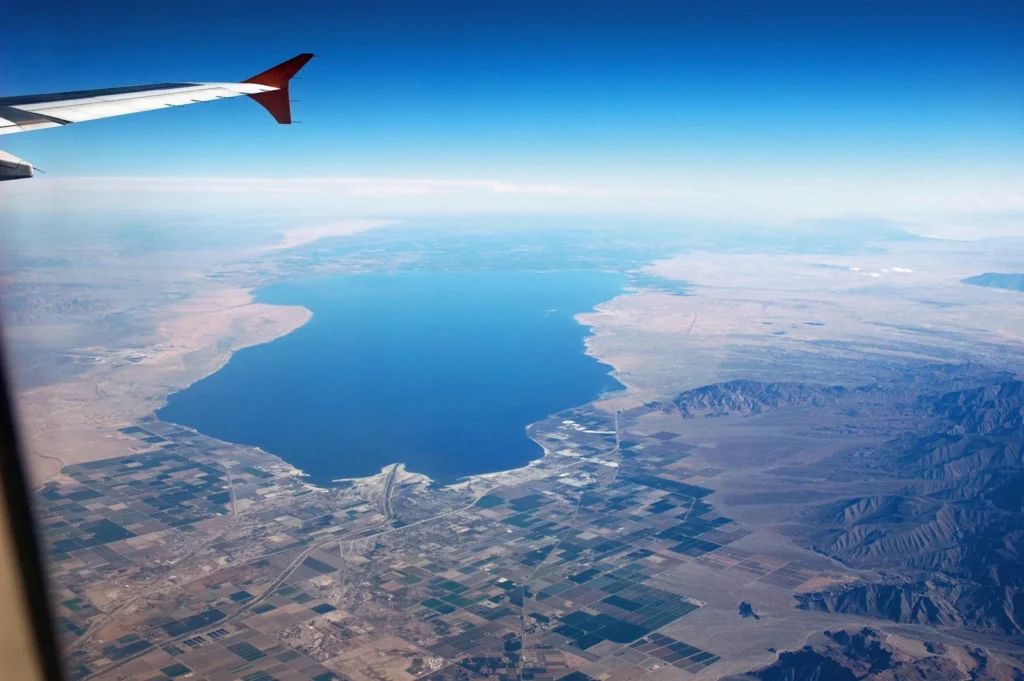
The same caution applies to elevation and shoreline extent. A water level needs a reference datum, the vertical baseline against which it is measured. Two aerial photographs can show change, but neither becomes a current shoreline survey simply because it appears on a recently published page.
The State Water Board: April 2026 staff report describes inflows below evaporation and continuing exposure of lakebed. It should not be read as a November 2026 measurement or as evidence that all planned restoration acreage has been completed.
4. How water reaches the lake
The New and Alamo rivers bring water north toward the lake through the Imperial Valley. The New River passes from Mexico through the Mexicali–Calexico area; the Alamo also begins south of the international border. The Coachella Valley Stormwater Channel is another named inflow route, entering from the north.
These routes include agricultural drainage rather than functioning only as undisturbed natural streams. The regional Water Board’s Colorado River Basin Water Board: Salton Sea watershed describes the drainage network. Its older flow totals are not used here as present-day measurements.
Changes in water conservation, irrigation practices, and transfers affect the amount reaching the lake. The Legislative Analyst’s Office explains that the 2003 Quantification Settlement Agreement was followed by water transfers and reduced agricultural return flows. Temporary mitigation-water requirements ended in 2017.
The resulting problem is not simply a missing river on the map. It is a water-budget imbalance in a managed landscape. That is different from a reservoir such as Lake Mead, whose geography also depends on storage and releases at a dam. The Salton Sea has no comparable surface outlet controlling releases downstream.
5. What restoration changes on the ground
When water retreats, previously submerged lakebed becomes exposed. This dry surface is called playa. Some exposed areas can emit windblown dust, while changing water conditions also affect aquatic habitat. Restoration therefore involves both the water and the land left behind.
“Restoration” does not automatically mean refilling the entire lake to an earlier shoreline. The Legislative Analyst’s Office: 2024–25 Salton Sea Management Program distinguishes projects that create habitat or suppress dust from restoration of the whole sea to its former condition.
How managed habitat ponds differ from the open lake
The Species Conservation Habitat project at the southern end uses constructed ponds and water-management infrastructure. Its design mixes New River water with Salton Sea water, with berms and conveyance features helping manage the resulting habitat.
The project tracker, updated January 29, 2026, reported 4,910 acres (about 1,990 hectares) of constructed ponds and 2,010 acres (about 810 hectares) of filled ponds. Those are different milestones. A constructed footprint is not automatically a functioning, water-filled habitat area.
These dated figures illustrate how to read a restoration update; they are not a claim about the completed area today. For subsequent progress, consult the Species Conservation Habitat project tracker and distinguish planned, built, filled, and operational acreage.
A watershed map cannot show all these distinctions. It locates the setting, while a project map identifies individual works and a monitoring record explains their condition. Treating those three kinds of information separately gives a clearer picture than one undated outline labeled “restored.”
What Did We Learn Today?
The Salton Sea’s geography combines a transboundary drainage setting, an older sequence of Lake Cahuilla phases, and a modern lake sustained partly by managed water flows. Its salt balance and retreating shoreline cannot be understood from the 1905 flood alone. Maps, measurements, and restoration totals become more useful when their dates and purposes are kept distinct.
Sources & Data Notes
Historical dates and physical processes are distinguished from dated restoration reports. The January and April 2026 records are not presented as real-time conditions. No single current lake area, elevation, or exact salinity is claimed.
Map method: the USGS WBD basin polygon and NHD lake geometry are shown in a north-up regional projection, with Natural Earth borders. The generalized outline is not a flood-risk or legal boundary. Featured photograph: USGS, March 1, 2006, public domain; it does not show the present shoreline.
- USGS: Water Availability in the Salton Sea Watershed
- USGS Earthshots: The Lake’s Formation
- Rockwell and colleagues (2022): Lake Cahuilla chronology
- Colorado River Basin Water Board: Salton Sea watershed
- USGS (2013): Ecosystem Monitoring and Assessment Plan
- State Water Board: April 2026 staff report
- Legislative Analyst’s Office: 2024–25 Salton Sea Management Program
- Species Conservation Habitat project tracker