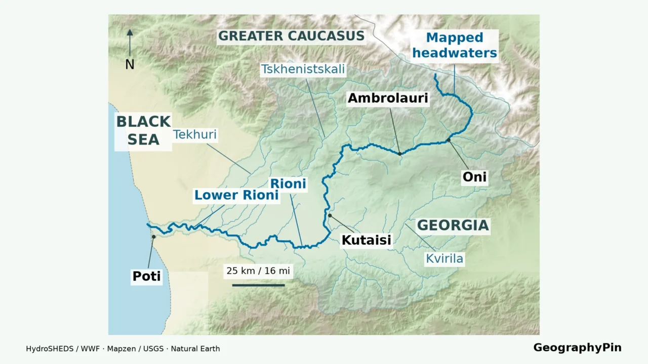
The Rioni links the Greater Caucasus with Georgia’s Black Sea coast, but its route is not a straight line from mountains to sea. Its tributary basin, changing valley shape and modified outlets near Poti explain more than a single blue line can.
The Rioni flows through western Georgia from the Greater Caucasus, through Racha and Kutaisi, across the Kolkheti Lowland to the Black Sea near Poti. Its tributaries drain a much wider mountain-and-lowland basin. Near the coast, engineered channels mean the modern outlet system is not an unchanged natural river mouth.
How to use this article: Follow the downstream route, compare station-based flow figures, or understand the modified mouth near Poti.
1. Read the Rioni River Map
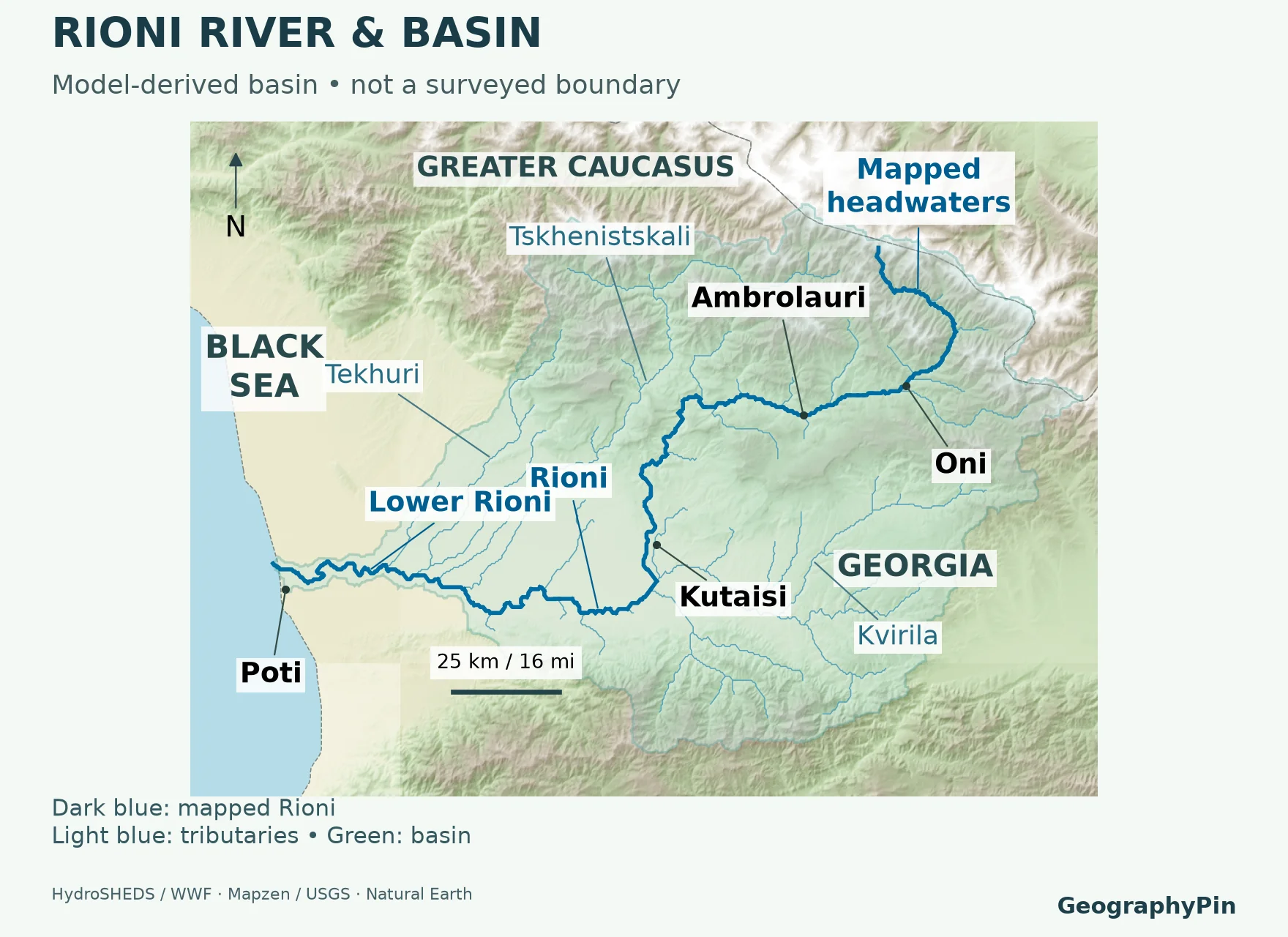
The Rioni runs through western Georgia, on the Black Sea side of the country’s drainage divide. Its headwaters are in the Greater Caucasus, not in the mountains along Georgia’s southern frontier. Follow the main river through Racha and toward Kutaisi, then westward across the Kolkheti Lowland to the coast near Poti.

Separate the river network from the terrain
The strong blue line identifies the selected main channel. Finer branches bring water from tributary valleys. Terrain colors show relative elevation; the separate basin outline encloses land draining into the river network. It is neither a national border nor a flood extent. Oni and Ambrolauri anchor the upper route, while Kvirila, Tskhenistskali and Tekhuri identify selected tributary systems.
On a river map, moving downstream does not necessarily mean moving down the screen. Here the route bends through the mountains before crossing the lowland. Use the connected channel, the town labels and the sea together rather than assuming a straight north–south journey. A branch meeting the Rioni is a tributary; it does not become the main stem merely because it looks straighter.
This is a geographic reference, not a navigation chart. The map does not show safe boating routes, live water levels, every dam or the edge of a particular flood. For the country’s wider drainage pattern, use the Georgia rivers map.
2. Follow the River from Racha to Poti
The downstream sequence
The simplest way to learn the route is to divide it into mountain, foothill and lowland reaches. These are explanatory stretches, not official river-management boundaries. The sequence below follows the river, not a road itinerary.
| Reach | What to look for |
|---|---|
| Upper Racha | Mountain headwaters and the upper valley leading toward Oni. |
| Oni–Ambrolauri | The Racha river corridor, with side valleys feeding the main channel. |
| Alpana–Tvishi | The river turns south and passes through constricted valley sections toward Kutaisi. |
| Kutaisi | The river crosses the city before continuing into the broad western lowland. |
| Samtredia area–Poti coast | The lower river crosses the Kolkheti Lowland; its outlet area includes engineered channels. |
In the mountains, the river’s bends and narrower passages make more sense when read against the relief. The basin study by Dvalashvili and colleagues describes the southward turn near Alpana and the constriction near Tvishi. These landmarks explain why an outline drawn directly from the headwaters to Poti would miss the river’s actual geography.
Kutaisi is the clearest urban reference point on the main channel. The Rioni is not simply a river somewhere outside the city: its banks and bridges are part of the cityscape. The separate Kutaisi travel guide covers visits and day trips without turning this river profile into a travel itinerary.
Downstream, the landscape opens out. At this scale, Samtredia is a useful lowland reference, while Poti identifies the coastal end of the system. Neither place should be treated as a precise river-mouth coordinate. The channel and the settlement are different mapped features.
3. Which Tributaries Feed the Rioni?
Read left and right while facing downstream
A river’s left bank and right bank are defined while looking in the direction of flow. They are not permanently equivalent to east and west. This matters along the Rioni because the main channel changes direction between Racha, Kutaisi and the lower plain.
| Tributary | Bank of the Rioni |
|---|---|
| Jejora | Left |
| Lukhuni | Right |
| Lajanuri | Right |
| Kvirila | Left |
| Khanistskali | Left |
| Tskhenistskali | Right |
| Tekhuri | Right |
Georgia’s Fourth National Communication lists these tributaries in its basin description. Spellings can vary between English-language maps, particularly Kvirila/Qvirila and Tskhenistskali/Tskhenistsqali. A spelling difference alone does not establish a second river.
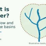
A tributary basin nests inside a larger basin. Water from a side valley reaches the Rioni through its own channel network, so the main catchment extends well beyond the narrow strip of land beside the main stem. Some smaller streams first enter another tributary. Listing every river in the basin as if it joined the Rioni directly would misrepresent those connections.
The USGS explanation of watersheds makes the outlet fundamental: a basin is the land draining toward a chosen downstream point. Move that point upstream, and the contributing area changes. A basin measured at a gauging station is therefore not automatically the total basin reaching the sea.
The practical test is to trace the connections, not compare names or colors. Two valleys on the same side of a mountain range may have different outlets. Conversely, a place far from the Rioni’s own banks may still send water into the Rioni through several intervening streams.
4. Length, Basin Area and Flow Are Different Measurements
Keep the definition beside the number
Geostat’s Statistical Yearbook of Georgia 2020, table 1.3, lists the Rioni at about 203 miles (327 kilometers), with a catchment of approximately 5,174 square miles (13,400 square kilometers). These are published reference figures, not measurements newly calculated from the map on this page.
Length measures a path along the river. Basin area measures a surface surrounding an entire drainage network. They answer different questions, and neither tells you how much water is passing a bridge today. A generalized digital line can be shorter than a published river length because it omits small bends and may begin at a different headwater cutoff.
A flow figure needs a station and a period
The 2021 Fourth National Communication provides an explicitly dated comparison in table 4.5.14. Its 1971–2000 baseline mean discharge is about 3,779 cubic feet per second (107 cubic meters per second) at Alpana and 16,033 cubic feet per second (454 cubic meters per second) at Chaladidi. These are historical baseline values used in that report’s climate assessment, not live readings or guaranteed annual flows.
The same report’s general station table gives different long-term normal values, without specifying the averaging period there. Keeping the dated baseline separate avoids silently mixing two statistical definitions. Neither table provides one timeless discharge for every point on the river.
Discharge means water volume passing a cross-section per unit time. Water level, also called stage, is a height relative to a gauge’s reference level. As the USGS streamflow guide explains, converting stage to flow requires a site-specific relationship. A reading in feet or centimeters cannot be compared directly with one in cubic feet or cubic meters per second.
Georgia’s NEA hydrological-data page includes Rioni stations. Check the timestamp, station and measurement type before using any displayed value. A historical mean is useful for understanding the river system; it is not a flood forecast.
5. What the Elevation Profile Shows
The mountain-to-coast contrast is the central physical story. A longitudinal profile follows distance along the river route, rather than a straight line across the map. It helps show how the highland corridor gives way to much lower terrain toward the Black Sea.
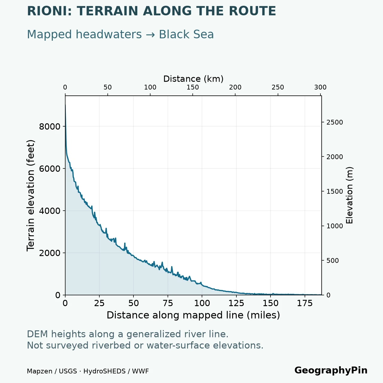
Read both axes before interpreting the shape. An elevation chart often expands the vertical dimension so the descent remains visible. Its steep-looking slopes are not literal views of a hillside, and a small irregularity is not proof of a waterfall.
The sampled heights describe the elevation dataset at the mapped route. In narrow valleys, imperfect alignment between a coarse river line and an elevation grid can place a sample on a bank or hillside rather than the water. Buildings, vegetation, data resolution and reservoir surfaces can also affect what a terrain product represents.
For those reasons, this profile is for regional interpretation, not engineering, rafting gradients or calculating the height of a dam. Its upstream starting point is the beginning of the mapped river line, not a new claim about the precise natural source. A measured channel-bed profile would require different field data.
The geographic conclusion is more robust than any individual plotted height: the Rioni links Greater Caucasus headwaters with the western lowland and the Black Sea. That progression is visible in the route, relief and profile together.
6. Why the Mouth near Poti Needs Special Care
The natural river and modified coastal outlets
It is accurate to say that the Rioni reaches the Black Sea near Poti. It is less accurate to imply that every modern outlet follows an unchanged natural course. A study in the Journals of Georgian Geophysical Society documents the river’s diversion in 1939 and subsequent growth of a new delta.
The northern diversion and the channel through the Poti area must therefore be distinguished when reading detailed coastal maps. A regional river line cannot show every branch, control structure or dredged channel. Older maps can depict a different arrangement from newer ones without either necessarily being a simple drawing error.
A delta is built and reshaped by sediment delivery, river flow and coastal processes. The study describes both deposition and the influence of human interventions on the evolving coast. Its observations are historical evidence, not a guarantee that a particular shoreline segment is still advancing at the same rate.
Do not assign a fixed percentage of the Rioni’s flow to each outlet without a dated, appropriately located measurement. A discharge observed upstream is not a separate measurement of every downstream branch. Likewise, a shaded drainage basin does not identify which coastal parcel will flood during a storm.
The safest reading sequence is to locate the wider mouth area, identify the date and scale of the detailed map, then distinguish the natural river system from engineered channel geometry. This preserves the useful geographic answer without pretending that a small reference map is a current harbor survey.
Frequently Asked Questions
Why do older references call the river Phasis?
Phasis is a classical name associated with the Rioni. However, historical writers did not always apply river names to exactly the same modern channel. Scholarship on ancient geography discusses identifications involving the Rioni and Kvirila, among others. Use modern Rioni geography for this map rather than assuming every ancient reference describes its entire present course.
What Did We Learn Today?
The Rioni map works best when several layers stay distinct: the main river, tributary network, whole drainage basin and modified coastal channels. Route order explains the mountains-to-lowland journey; station and period explain flow figures; the elevation profile illustrates regional terrain rather than a surveyed riverbed. Together, those distinctions turn a location map into a useful account of western Georgia’s river geography.
Sources & Data Notes
Reference length and basin area follow Geostat; flow examples preserve the 1971–2000 baseline and station definitions in the 2021 national communication. Conversions are rounded. Original GeographyPin graphics combine HydroRIVERS, a model-derived HydroBASINS level8 catchment, and Mapzen terrain. The modeled outline is not the source of the Geostat area statistic; they are not flood forecasts, navigation charts or surveyed channel profiles. Coastal history is attributed to the delta study rather than treated as a present-day engineering survey.
- Geostat — Statistical Yearbook of Georgia 2020, table 1.3
- Fourth National Communication of Georgia, 2021, section 4.5 and tables 4.5.10–4.5.14
- Dvalashvili and colleagues — Rioni basin landforms and river route, 2017
- Main Regularities of Forming a New Delta of Rioni River
- USGS — Watersheds and Drainage Basins
- USGS — How Streamflow is Measured
- National Environmental Agency — hydrological data
- HydroRIVERS — river-network data
- Phasian Confusion — historical river-name interpretation
- HydroBASINS-derived global catchment layer — The Nature Conservancy distribution
This product GeographyPin Rioni River Map incorporates data from the HydroSHEDS version 1 database which is © World Wildlife Fund, Inc. (2006-2022) and has been used herein under license. WWF has not evaluated the data as altered and incorporated within GeographyPin Rioni River Map, and therefore gives no warranty regarding its accuracy, completeness, currency or suitability for any particular purpose. Portions of the HydroSHEDS v1 database incorporate data which are the intellectual property rights of © USGS (2006-2008), NASA (2000-2005), ESRI (1992-1998), CIAT (2004-2006), UNEP-WCMC (1993), WWF (2004), Commonwealth of Australia (2007), and Her Royal Majesty and the British Crown and are used under license. The HydroSHEDS v1 database and more information are available at HydroSHEDS.
Terrain: Mapzen Terrain Tiles, incorporating SRTM and GMTED2010 data courtesy of the U.S. Geological Survey, NOAA ETOPO1, and Copernicus-funded EU-DEM data. Natural Earth basemap data are public domain. Oni and Ambrolauri locators use GeoNames data under CC BY 4.0. Source organizations do not endorse this adaptation. Terrain source attribution; Natural Earth terms.