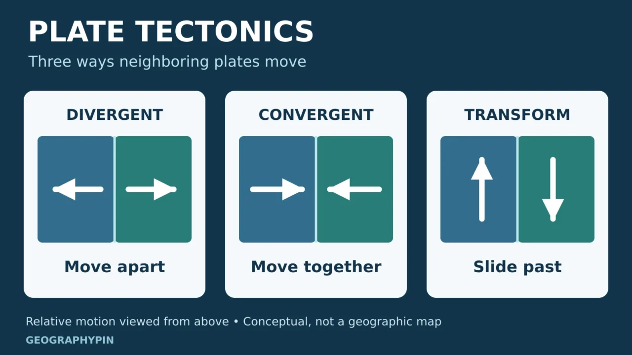
Continents move, ocean floors spread, and mountain ranges rise because Earth’s outer shell is moving. Understanding plate tectonics starts with a distinction that simple maps can hide: a continent, Earth’s crust and a tectonic plate are different things.
Plate tectonics is the theory that Earth’s lithosphere, made of crust and rigid uppermost mantle, is divided into plates that move relative to one another. They separate, converge or slide past at boundaries. These interactions help explain ocean basins, mountain building, and the concentration of earthquakes and volcanoes. The plates move over mostly solid mantle that can flow slowly.
How to use this article: Start with what a plate contains, compare subduction and collision, or see how plate movement is measured.
1. What Is a Tectonic Plate?
A tectonic plate is a large, relatively rigid part of Earth’s outer shell. A single plate can carry both a continent and ocean floor. Plate edges therefore do not simply follow coastlines, and a continent can extend across more than one plate.
Crust and lithosphere are different layers
Crust is Earth’s outermost rocky layer. Lithosphere includes that crust plus the rigid uppermost mantle beneath it. The whole lithosphere forms the moving plate. Calling plates “pieces of crust” leaves out a substantial part of their structure.
Below the lithosphere is the asthenosphere, a weaker region of the upper mantle. Its rock is mostly solid, but it can deform and flow over long periods. This behavior is called ductile deformation. Plates do not float on a global ocean of liquid magma.
The distinction also matters on a political map. Iceland’s position between the North American and Eurasian plates describes its geology. It does not by itself determine the country’s continental classification.
2. Three Ways Plates Meet
A boundary type describes the motion of neighboring plates relative to each other. The three basic types are divergent, convergent and transform. These diagrams isolate each motion; real boundaries can combine sideways movement with stretching or compression.
Divergent: plates move apart
At a divergent boundary, the distance between the plates increases. Along mid-ocean ridges, hot mantle rises as the plates separate. Falling pressure allows some mantle rock to melt, and magma cools to form new oceanic crust. This is seafloor spreading.
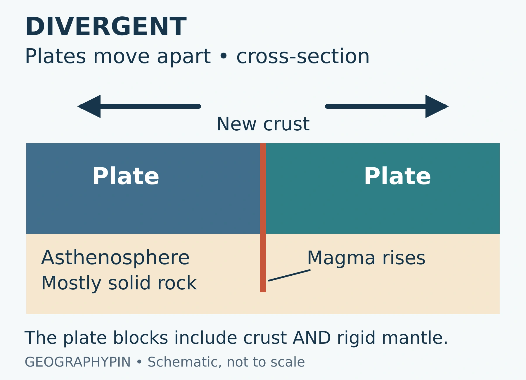
The Mid-Atlantic Ridge is an example. Divergence can also stretch continental lithosphere, creating a rift such as the East African Rift. A continental rift is not automatically an open ocean.
Convergent: subduction or continental collision
At a convergent boundary, plates move toward each other. In subduction, one plate descends beneath another into the mantle. Oceanic lithosphere can sink beneath a continent or beneath another oceanic plate. Trenches, earthquakes and volcanic arcs are common features of these settings.
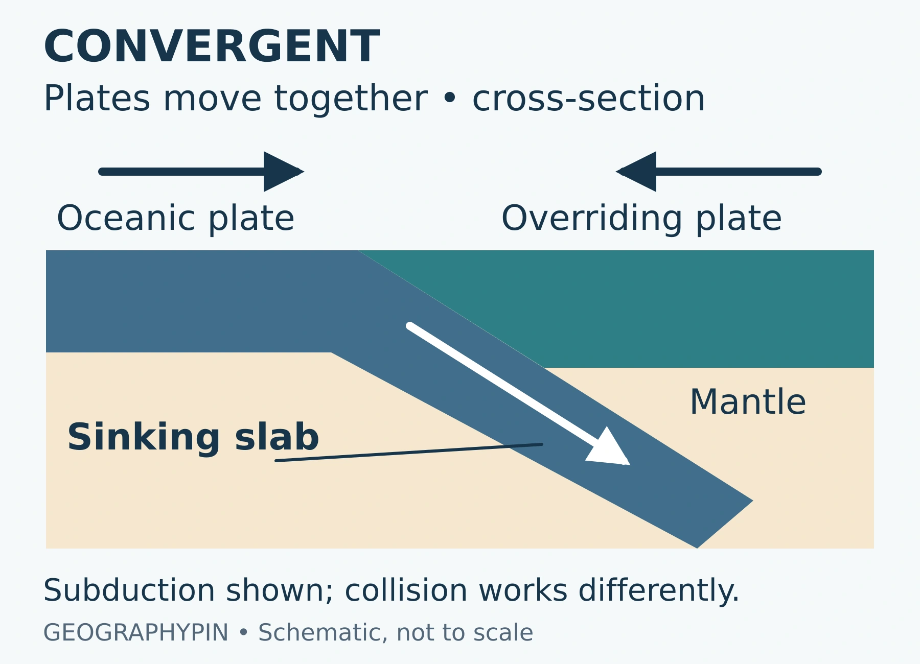
Subduction-related volcanoes are not simply made by melting the descending plate. As the slab goes deeper, it releases water and other fluids. These can lower the melting temperature of mantle rock above the slab, producing partial melting. The USGS explanation of Cascadia describes this process beneath the Cascade volcanoes.
When two continental regions converge, their buoyant crust resists sinking deep into the mantle. Rocks shorten, fold, fault and thicken, building mountains such as the Himalayas. One side can be pushed beneath the other, but continental collision is not equivalent to an oceanic slab descending beneath a volcanic arc.
Transform: plates slide past each other
At a transform boundary, the main motion is sideways, parallel to the boundary. This motion does not itself create or consume lithosphere. California’s San Andreas fault system is a familiar example.
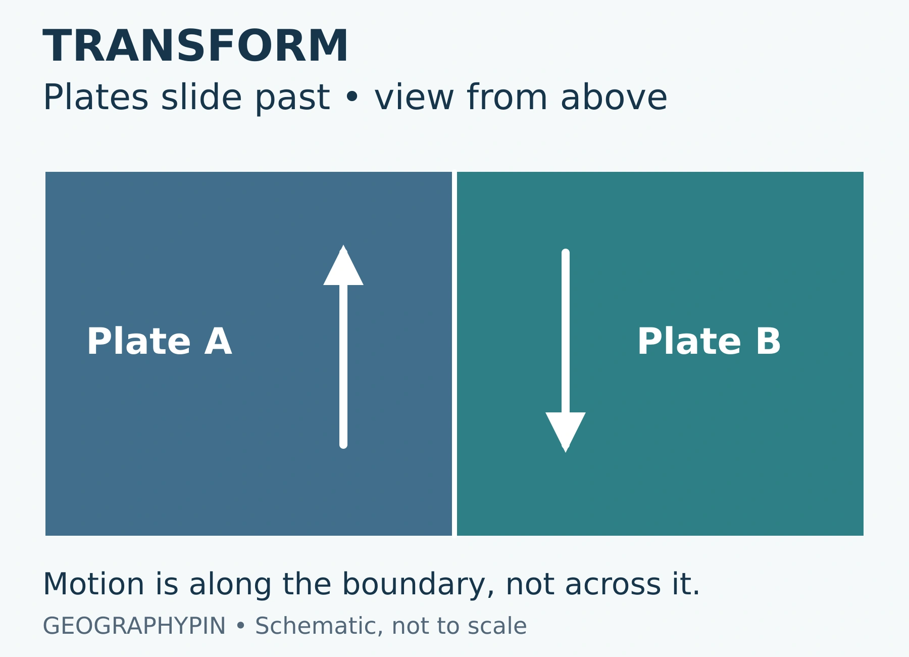
Friction can lock parts of a fault while surrounding rock continues to deform. A sudden slip releases stored strain as an earthquake. Bends and irregularities can also cause local compression or stretching, so a transform zone is rarely a perfectly straight sliding seam.
3. Why Tectonic Plates Move
Earth’s internal heat and gravity power a connected system of mantle circulation and plate motion. The plates are part of that system, rather than passive rafts carried by a simple conveyor belt beneath them.
- Slab pull: cold, dense oceanic lithosphere sinking at a subduction zone can pull the attached plate behind it. This is a major driving force.
- Ridge push: young, warm lithosphere stands higher at a spreading ridge than older oceanic lithosphere farther away. Gravity produces a force directed away from the elevated ridge. The name does not mean magma mechanically shoves every plate along.
- Mantle interaction: moving mantle and moving plates exert forces on one another. The motion of a particular plate reflects both driving forces and resistance.
The relative importance of these forces varies with a plate’s setting. A diagram of neatly rotating convection cells can introduce heat transfer, but it should not be read as a literal engine under every plate. EarthScope’s IRIS teaching resource on plate-driving forces places slab pull and ridge push within the larger convection system.
4. How We Know Plates Are Moving
Measurements need a reference
Plate movement is generally measured on the scale of fractions of an inch to a few inches per year, or centimeters per year. There is no single speed for all plates. A useful velocity states the location, direction, time interval and reference frame, such as movement relative to a neighboring plate.
Satellite positioning systems, including GPS, repeatedly measure the positions of stations fixed to the ground. Changes in their positions reveal motion and deformation. USGS distinguishes these direct measurements from rates averaged over geological time using the rock record.
To classify motion at a nearly straight boundary, separate movement across the boundary from movement along it. Moving apart across it is divergence; moving together across it is convergence. Sliding along it is transform motion. A real boundary can have both components, so changing distance between two stations alone is not enough to identify the type.
The ocean floor preserves a longer record
Oceanic crust is generally youngest at spreading ridges and becomes older away from them. Magnetic minerals in cooling rocks also preserve a record of Earth’s magnetic field. Matching bands of normal and reversed magnetic polarity on opposite sides of ridges support seafloor spreading.
Earthquake locations add a different kind of evidence. Their patterns help outline plate boundaries, while earthquakes extending down into the mantle trace descending slabs. Together, satellite measurements, seafloor ages, magnetic patterns and seismic observations explain far more than a visual fit between continental coastlines alone.
5. Reading the Landscape Without Overgeneralizing
Plate tectonics helps explain why many trenches, volcanic arcs and earthquake belts occur around the Pacific Ocean. It also explains why the edge of an ocean is not always an active plate boundary: a coastline can lie well inside a plate.
Most earthquakes occur near plate boundaries, but not all. Stress can act on old faults within plate interiors. Volcanoes also occur away from boundaries, including those associated with hotspots such as Hawaii. Neither an earthquake nor a volcano, by itself, proves that a plate boundary passes through a location.
Finally, tectonic uplift does not explain every detail of a mountain’s shape. Rivers, glaciers, weathering and slope movement reshape the rock while and after mountains rise. The distinction between building relief and landforms carved by erosion helps explain why a landscape records several processes at once.
What Did We Learn Today?
To read plate tectonics correctly, identify the moving material first: the lithosphere includes both crust and rigid mantle. Then ask how neighboring plates move relative to each other. Divergence, convergence and transform motion produce different structures, while subduction and continental collision produce different kinds of convergence. Gravity, heat and mantle flow connect the system, and independent measurements from satellites, rocks and earthquakes make the movement testable.
Sources & Data Notes
The diagrams are original conceptual drawings, not maps or scaled models. Arrows show relative motion, not measured speeds. The subduction panel represents one convergent setting; it does not depict continental collision. The article uses broad movement scales rather than assigning an undated velocity to each plate. Real boundary zones can be wide, deform internally and combine motion types.
- University of Michigan: Whole Earth Structure and Plate Tectonics, for lithosphere, relative motion and driving forces.
- National Park Service: Plate Tectonics, The Unifying Theory of Geology, for the distinction between continents and plates and for seismic evidence.
- British Geological Survey: What causes earthquakes?, for mantle behavior, plate motion, boundary types and continental collision.
- National Park Service: Types of Plate Boundaries, for boundary comparisons and the broad scale of plate speeds.
- USGS: Juan de Fuca Plate subduction diagram and explanation, for water release and partial melting above a slab.
- EarthScope/IRIS: What Are the Forces that Drive Plate Tectonics?, for gravity and the convection system.
- USGS: How fast do tectonic plates move? and NOAA: Age of the Seafloor, for direct measurements and geological evidence.
- Smithsonian Ocean: How the Ocean Floor Helped Seal the Deal for Plate Tectonics, for magnetic-stripe evidence.
- USGS: Why do earthquakes occur far from plate boundaries?, for earthquakes within plate interiors.