The North Sea looks like a compact stretch of water on a world map, yet it connects some of Europe’s busiest coasts with the Atlantic. Its shallow seabed helps explain its tides and coastal hazards, while different definitions explain why lists of bordering countries do not always match.
The North Sea lies between Great Britain and mainland northwestern Europe. It connects with the Atlantic to the north and through the English Channel. Much of it is shallow continental-shelf water, with a deeper Norwegian Trench alongside Norway. Country lists depend on whether adjoining waters such as the Skagerrak are included.
How to use this article: Follow the map’s connections, compare country-list conventions, examine the shelf and trench, or distinguish tides, currents and waves.
1. Where is the North Sea?
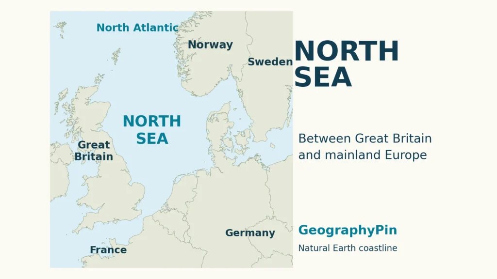
The North Sea lies between Great Britain and mainland northwestern Europe. It belongs to the Atlantic system rather than forming a landlocked basin: water can move through its broad northern opening and through the much narrower connection with the English Channel in the southwest.
Follow the coasts, then the openings
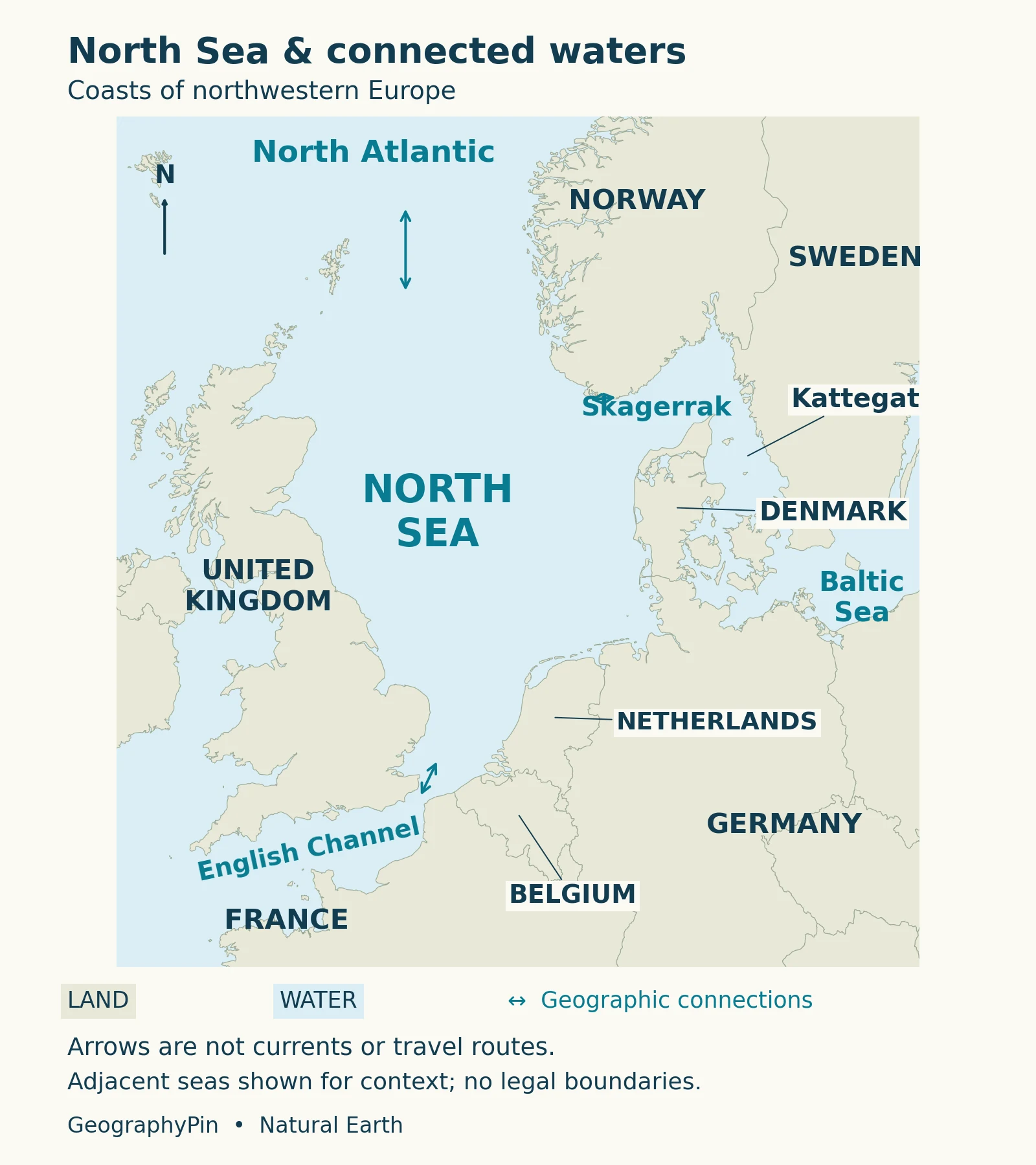
On the map, Great Britain provides the western frame. Norway lies toward the northeast, Denmark to the east, and the low continental coasts curve around the southern side. The Strait of Dover separates southeastern England from northern France, linking the southern North Sea with the Channel.
To the east, the route toward the Baltic passes through the Skagerrak, Kattegat and Danish straits. These are connected waters, not alternative names for the same sea. The restricted connection helps explain why the Baltic is brackish. A regional map may include them to explain circulation even when its geographic definition treats them separately.
The world ocean map supplies the larger context: named seas and oceans are subdivisions of connected water. A geographic name does not create a physical barrier across an opening.
2. Which countries border it? State the convention first
A country list needs a stated meaning of “North Sea.” Using the sea limits in the International Hydrographic Organization’s Limits of Oceans and Seas, third edition (1953), the coastal countries are the United Kingdom, Norway, Denmark, Germany, the Netherlands, Belgium and France.
Why some lists also include Sweden
The IHO convention separates the Skagerrak from the North Sea at a line between Hanstholm in Denmark and Lindesnes in Norway. Sweden’s relevant coast faces the Skagerrak and Kattegat, beyond that limit. At the other end, the specified Channel boundary leaves part of France’s northern coast on the North Sea side.
| Scope | How to read its country list |
|---|---|
| IHO North Sea limits (1953) | Seven coastal countries in the list above; the Skagerrak is separately delimited. |
| OSPAR Greater North Sea, Region II | Belgium, Denmark, France, Germany, the Netherlands, Norway, Sweden and the United Kingdom. |
OSPAR’s broader region includes adjacent waters and is used for regional marine assessment. Its eight-country list is appropriate when clearly labeled Greater North Sea. It should not silently replace a narrower sea-name definition.
These conventions also affect published area and volume figures. A number for a region including adjoining waters, estuaries and fjords cannot be compared directly with one for the smaller sea proper. Neither a sea-name limit nor the outline of an environmental reporting region determines territorial waters or exclusive economic zones.
3. A shallow shelf with a deeper exception
The North Sea covers part of Europe’s continental shelf, the submerged margin of the continent. Its seabed is not a uniform flat floor, but much of the water is shallow compared with the deep ocean beyond the shelf.
The Norwegian Trench changes the picture
Norway’s Institute of Marine Research describes roughly two-thirds of the North Sea as shallower than about 330 feet (100 meters), with northern shelf areas commonly about 330–660 feet (100–200 meters) deep. The Norwegian Trench is a pronounced deeper feature alongside Norway, extending into the Skagerrak.
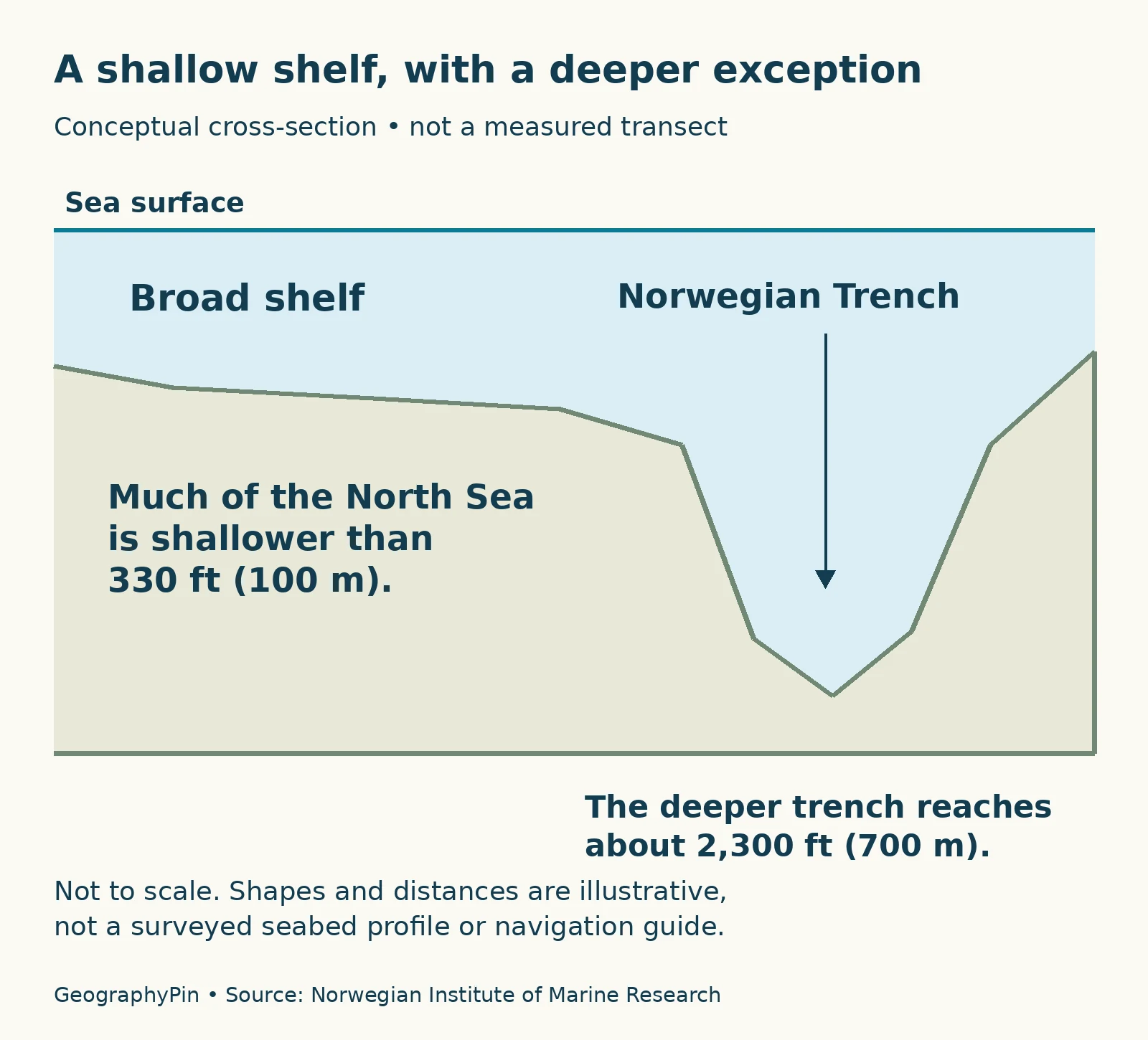
Across the wider North Sea–Skagerrak system, the trench reaches depths on the order of 2,300 feet (700 meters). That approximate scale is useful for understanding the contrast with the shelf; it is not an exact maximum for every definition of the North Sea region.
Depth differences influence more than the amount of water above the bed. They help shape current pathways, mixing and the distribution of marine habitats. A shallow bank and a deeper channel can therefore behave differently even when both appear as the same blue area on an ordinary political map.
The cross-section isolates this contrast rather than tracing a surveyed line between two towns. Use its broad shelf and deeper depression to understand the landform; use a bathymetric dataset or nautical chart for the depth at a particular coordinate.
4. Tides, currents and waves are different movements
A changing shoreline, a strong current and rough waves can occur together, but they describe different properties of the water. Keeping them separate is essential when interpreting the North Sea.
Height is not speed
| Process | What changes | Useful distinction |
|---|---|---|
| Tide | Water level rises and falls. | Tidal range is a vertical height difference. |
| Current | Water flows horizontally. | Current speed is not a tidal-range measurement. |
| Wind waves | Shorter waves travel across the surface. | Rough waves do not by themselves identify high tide. |
NOAA explains that the Moon and Sun drive tides, while currents can be driven by tides, wind and density differences. A tidal current is therefore one kind of current, not a synonym for all circulation.
North Sea tidal motions are strongly influenced by tidal waves entering from the Atlantic. A 2024 study by Deyle and colleagues, using surface drifters deployed during 2017–2021, documents the contrast between strongly tidal shallow waters and the deeper Skagerrak, where other circulation processes become important.
The National Oceanography Centre emphasizes that tide heights and times vary along a coastline and from day to day. There is no single tidal range or high-water time that applies to the entire North Sea. A tide prediction for one port should not be treated as the schedule for another coast.
5. Why a storm surge can raise the flood risk
A storm surge is a weather-driven change in sea level, not the ordinary astronomical tide. Strong winds can push water toward a coast, while low atmospheric pressure also contributes to a rise. Wind direction, storm strength and the shape of the coast and seabed affect the result.
The timing of the storm matters
The Met Office describes the January 1953 North Sea disaster as a storm surge coinciding with a high spring tide. The lesson is not that every high tide is dangerous, but that a raised background water level can make a storm’s coastal effects much worse.
Large waves can act on top of an elevated water level and overtop defenses. Conversely, winds that drive water away from a coast can produce a negative surge, lowering the level. These are changes in water level caused by weather, not evidence that the tidal cycle has stopped.
For a particular place and date, use current official coastal flood warnings and local tide information. A geographic explanation of storm surges cannot determine whether a beach, harbor or coastal road is safe during an approaching storm.
6. Rivers, tidal coasts and a heavily used sea
The North Sea connects large drainage basins with marine water. Rivers including the Rhine, Elbe and Thames deliver freshwater to its coastal zone. Freshwater and saltier seawater differ in density, contributing to the complex movement and mixing of water rather than producing one permanently uniform salinity everywhere.
The Wadden Sea shows the intertidal landscape
Along the Netherlands, Germany and Denmark, the Wadden Sea contains extensive sand and mudflats that are alternately covered and exposed by the tide. UNESCO describes a connected system of tidal channels, barrier islands, salt marshes and other coastal habitats.
This is not simply a strip of empty beach. Its shallow-water and exposed-flat habitats support feeding and resting wildlife, including migratory birds. The relationship between tidal flooding, sediment movement and living organisms is central to the landscape’s importance.
Elsewhere, different coastal forms and seabed settings support different uses. Shipping, fishing, offshore oil and gas production, and sand and gravel extraction place human activity alongside the sea’s physical processes. OSPAR identifies these as major activities in the region.
A useful map of the North Sea therefore does more than label countries. It shows why ports, rivers, shallow coasts and Atlantic connections belong to one interacting marine system, while the boundary convention explains exactly which area a statistic describes.
What Did We Learn Today?
The North Sea’s geography combines connected waters, a mainly shallow shelf and contrasting coasts. A named boundary convention explains a country list; depth helps explain marine processes; and tides, currents, waves and storm surges describe different movements. Reading those distinctions together is more useful than treating the whole region as one uniform patch of water.
Sources & Data Notes
The narrower country list interprets the IHO’s 1953 sea-name limits; OSPAR’s Greater North Sea is a broader assessment region. Neither defines national maritime jurisdiction here. Depth figures are rounded regional descriptions, not a new survey. Natural Earth coastlines provide the map’s geographic base; the cross-section illustrates a concept without assigning depths to a measured route. No tidal prediction or navigation instruction is implied.
- IHO: Limits of Oceans and Seas, third edition (1953), printed page 6, North Sea and Skagerrak limits.
- OSPAR: Region II, Greater North Sea, regional scope and country list.
- Norwegian Institute of Marine Research: North Sea and Skagerrak, shelf depths and marine pressures.
- Deyle and colleagues (2024), surface-drifter observations and North Sea circulation.
- NOAA: tides and currents, distinction between water-level change and flow.
- National Oceanography Centre: storms, tides and waves, coastal processes and local variation.
- Met Office: storm surge, mechanisms and the 1953 North Sea example.
- UNESCO: Wadden Sea, intertidal habitats and coastal setting.
- Natural Earth terms of use, public-domain basemap data. Map and conceptual diagram: GeographyPin.