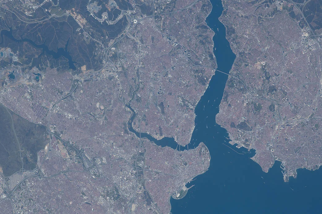
Istanbul is easier to understand once you stop treating every stretch of water as the same boundary. The Bosporus separates the city’s European and Asian sides. The Golden Horn divides two parts of European Istanbul. The Sea of Marmara opens south of both. Those three relationships explain far more than the familiar phrase “a city on two continents.”
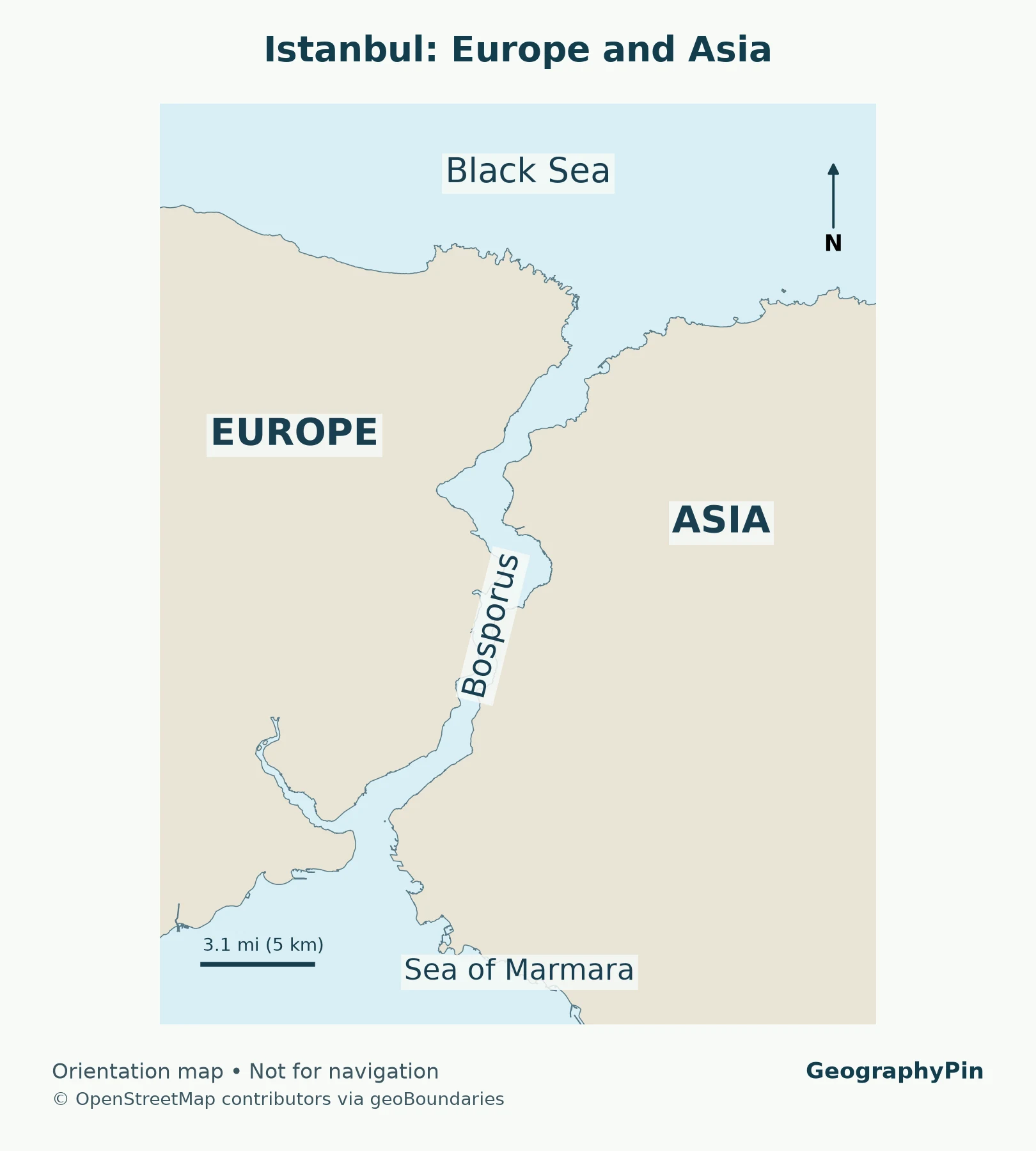
Istanbul is in both Europe and Asia, in northwestern Türkiye. The Bosporus Strait separates its European side from its Asian, or Anatolian, side and connects the Black Sea with the Sea of Marmara. The Golden Horn is a separate inlet on the European side, not the boundary between continents.
Find your bearings: Identify the continental crossing, distinguish the Golden Horn, or check what the population total measures.
1. Start with the Water, Not the Skyline
The Bosporus is the continental crossing
Find the long, narrow waterway running north from central Istanbul to the Black Sea. That is the Bosporus, also spelled Bosphorus and called İstanbul Boğazı in Turkish. Its western shore belongs to the European side; its eastern shore belongs to the Asian side. The waterway bends, so “west” and “east” describe the general sides rather than a perfectly straight dividing line.
This is a geographic convention within one country, not an international border. Both shores are in Türkiye. Crossing between them does not mean entering another country, and the two sides are not separate national capitals. Istanbul is a transcontinental city because its urban area extends across that conventionally recognized Europe–Asia divide.
At its northern end, the strait opens into the Black Sea. At its southern end, it opens into the Sea of Marmara. It does not empty directly into the Mediterranean, and it is not a river running through the city. A strait is a narrow natural connection between larger bodies of water. For the underlying distinction, see GeographyPin’s explanation of what a strait is.
The Golden Horn is a different kind of division
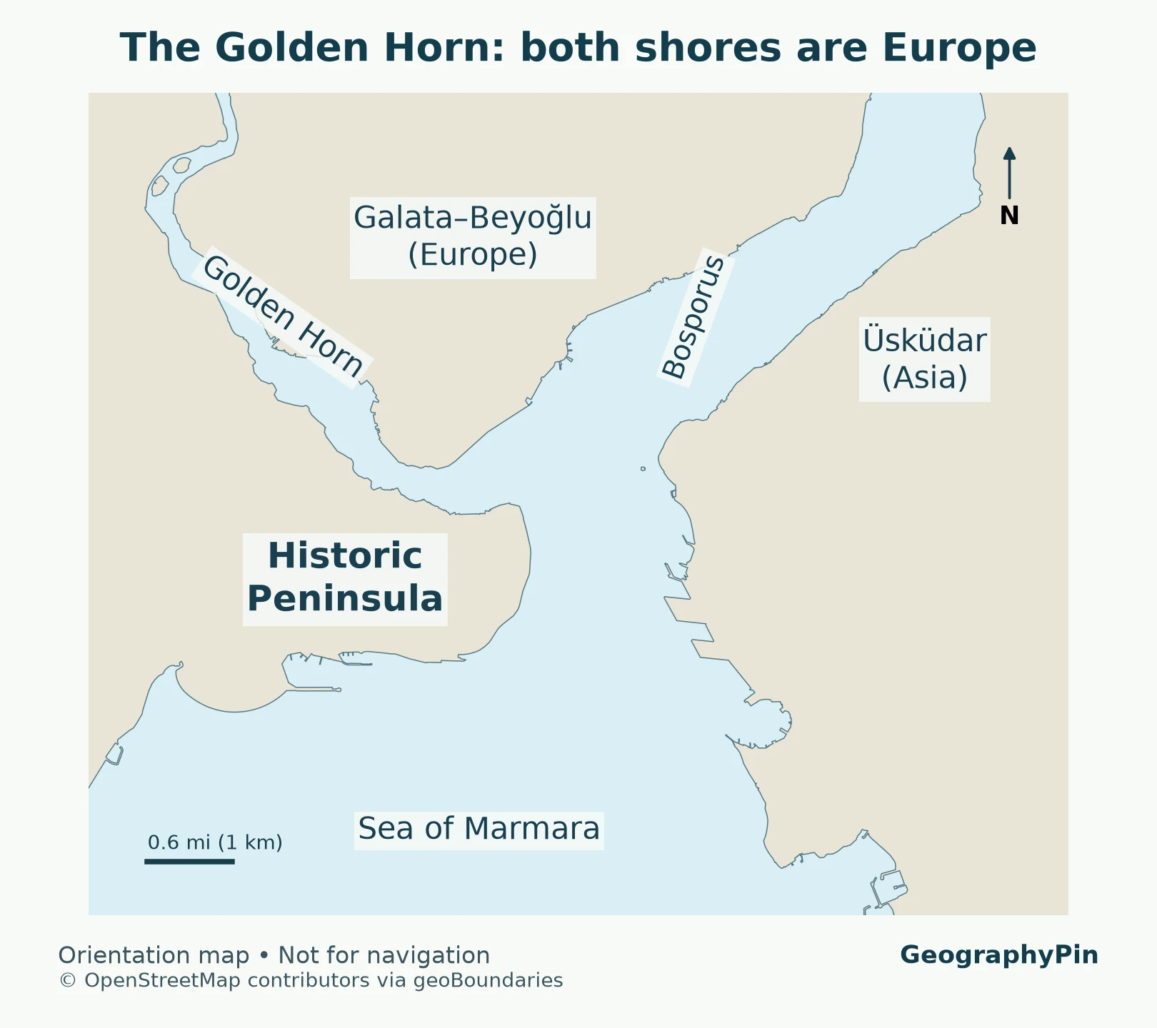
Near the southern end of the Bosporus, look for the inlet extending inland to the northwest on the European shore. This is the Golden Horn, or Haliç. It separates the Historic Peninsula to the south from the Galata–Beyoğlu side to the north. Both banks are European.
That difference matters when interpreting a photograph or choosing a crossing. A bridge over the Golden Horn does not take you to Asia. A crossing of the Bosporus does. The Golden Horn is a sheltered inlet and historic harbor, whereas the Bosporus is the through-route between two seas. They meet, but they do not have the same geographic role.
The Sea of Marmara is the southern reference point
The wider water south of the Historic Peninsula and the Asian waterfront is the Sea of Marmara. It is a sea, not another name for either the Bosporus or the Golden Horn. If you can identify those three features on a map, you can usually orient yourself even before recognizing any individual building.
2. Read Istanbul as Three Waterfront Areas
A useful first map divides the central waterfront into three areas rather than two. This is an orientation device, not a new administrative division or a claim that the rest of Istanbul is unimportant.
| Area | Continental side | Water relationship | Useful reference places |
|---|---|---|---|
| Historic Peninsula | Europe | Golden Horn to the north, Bosporus to the east, Marmara to the south | Sultanahmet and Eminönü |
| Galata–Beyoğlu side | Europe | North of the Golden Horn, west of the Bosporus | Galata and Karaköy |
| Asian waterfront | Asia | East of the Bosporus, extending along the Marmara shore | Üsküdar and Kadıköy |
The Historic Peninsula is where the older city associated with Byzantium and Constantinople developed. Its position placed water on three sides while land connections extended west. UNESCO’s description uses that same peninsula-and-water relationship to explain the setting of the Historic Areas of Istanbul.
Galata and Karaköy stand across the Golden Horn from the peninsula, not across the continental boundary. Beyoğlu extends inland from that northern waterfront. Describing everything north of the old city as “the Asian side” is therefore misleading. A northward move can keep you entirely within Europe.
Üsküdar is on the Asian shore near the southern Bosporus. Kadıköy lies farther south along the Asian side, facing the Sea of Marmara. They are useful reference points, but they do not define the whole Asian side. Istanbul extends well beyond the small central area most visitor maps emphasize.
The lesson is to identify the water crossed, not simply the direction of travel. “Across from the old city” could refer to the other side of the Golden Horn or to the other side of the Bosporus. Only the latter is a Europe–Asia crossing.
3. Follow the Route from the Black Sea to the Mediterranean
Two straits, with a sea between them
From northeast to southwest, the connected water route is:
Black Sea → Bosporus → Sea of Marmara → Dardanelles → Aegean Sea → Mediterranean Sea.
The Turkish Ministry of Foreign Affairs describes the Bosporus, Sea of Marmara and Dardanelles together as the Turkish Straits system. This wider system explains Istanbul’s strategic setting without requiring the inaccurate shortcut that the Bosporus alone directly joins the Black Sea to the Mediterranean.
The Dardanelles are a different strait, southwest of Istanbul at the other end of the Sea of Marmara. They should not be labeled as part of the Bosporus on a city map. The Aegean is part of the Mediterranean system, while the Marmara is the intervening sea between the two Turkish straits.
For ships moving between Black Sea ports and the Mediterranean, Istanbul sits beside a narrow passage within a much longer route. That geographic constraint helps explain the concentration of maritime activity. It does not mean a simple city map is adequate for navigation: currents, traffic rules, vessel dimensions and operational restrictions require specialist information.
For the larger continental question, see our guide to Europe’s continental status. A continental-boundary map and a city map answer different questions: one explains a geographic convention across Eurasia, while the other helps distinguish nearby shores.
4. Keep the City, Province and Historic Site Separate
What the population number measures
TÜİK’s Address Based Population Registration System reports 15,754,053 residents for Istanbul at the end of 2025. This is an administrative population count for Istanbul province, not a measurement of everyone within the compact historic center or a uniformly built-up outline drawn from satellite imagery.
Istanbul Metropolitan Municipality’s jurisdiction follows the provincial boundary. Its official administrative account identifies 39 districts. The administrative territory includes much more than the waterfront around Sultanahmet, Galata and Üsküdar, so the provincial population should not be attached to a small central-city map as if that map showed its entire counting area.
This also explains why two apparently conflicting population figures can describe different things. A provincial total, an urban agglomeration estimate and a historic-district count use different boundaries and may refer to different dates. Before comparing Istanbul with another city, match the geographic definition and reference year rather than comparing whichever large numbers appear first.
The map in this article is an orientation map, not a map of population density, settlement extent or administrative districts. Land color identifies geographic sides; it does not imply that every colored area is continuously urbanized.
What UNESCO lists
The World Heritage property is called Historic Areas of Istanbul. It consists of defined historic areas, not the entire modern metropolis. UNESCO’s listing includes the Archaeological Park, Süleymaniye, Zeyrek and the land walls area. Calling all of modern Istanbul a single UNESCO-listed site obscures those specific boundaries.
The historic importance of the peninsula helps explain the city’s geography, but it should not erase the modern city on either side of the Bosporus. “Old Istanbul,” “Istanbul province” and “the European side” are overlapping but different descriptions.
5. Use the Geography to Understand Everyday Crossings
A Golden Horn crossing stays in Europe
Going between Eminönü and Karaköy takes you between the Historic Peninsula and the Galata side of the Golden Horn. Both are European. That remains true even though the waterfront, skyline and local neighborhood change noticeably.
A Bosporus crossing changes continental sides
Going between Eminönü or Karaköy and Üsküdar crosses between Europe and Asia. The municipal ferry operator Şehir Hatları lists an Üsküdar–Karaköy–Eminönü service, making these names a practical example of the map’s relationships. Check the operator’s current timetable before traveling; this article does not promise a departure time, fare or uninterrupted service.
A ferry route may connect several stops and does not always trace a straight line across the water. Identify the departure and arrival shores rather than assuming every ferry ride crosses continents. Services along one shore, around the Golden Horn or between other local destinations can have a different geography.
These distinctions also help when reading accommodation descriptions. “Waterfront” alone does not tell you which sea or inlet is nearby, nor which continental side you are on. Look for the district and the named water body, then check the actual route to your destination.
6. Istanbul Is Not Türkiye’s Capital
Istanbul’s former roles as an imperial capital make this an understandable confusion. The national capital of modern Türkiye is Ankara, not Istanbul. Istanbul has the country’s largest provincial population in the TÜİK results discussed above, but population size and capital status are different attributes.
If you are comparing a political map with a population map, expect the two to emphasize different places. A capital symbol marks the seat of national government; a large urban symbol indicates settlement importance or population according to the map’s legend. Neither symbol changes Istanbul’s transcontinental setting.
For that separate question, see Why Ankara Is the Capital of Türkiye. Keeping it separate leaves this map focused on the city’s defining physical arrangement: a strait between continents, an inlet within its European side, and a sea to the south.
Frequently Asked Questions
Is Istanbul’s old city in Europe or Asia?
The Historic Peninsula, including Sultanahmet, is on the European side. The Bosporus lies to its east. Crossing the Golden Horn northward from the peninsula still leaves you in Europe.
Are Bosporus and Bosphorus different places?
No. They are alternative English spellings for the same strait. İstanbul Boğazı is its Turkish name.
Is the Golden Horn the Europe–Asia boundary?
No. Both shores of the Golden Horn are on Istanbul’s European side. The Bosporus is the continental dividing waterway at Istanbul.
What Did We Learn Today?
Istanbul is in both Europe and Asia, but not every crossing within the city changes continents. The Bosporus divides the two sides and links the Black Sea with the Sea of Marmara; the Golden Horn divides parts of European Istanbul. The Historic Peninsula, modern province and UNESCO property describe different areas, so maps and population figures make sense only when their boundaries are clear.
Sources & Data Notes
Maps are GeographyPin cartographic renderings of the geoBoundaries gbOpen Türkiye ADM0 layer, which identifies OpenStreetMap as its source and 2021 as the represented year. The geometry is clipped and projected to UTM zone 35N; coastlines are not hand-drawn. Labels identify broad areas, not district boundaries or surveyed points. Small waterfront changes after the source year may not appear. The source data and clipped derivative are available under the OpenStreetMap ODbL terms. The map graphics are offered under CC BY-SA 2.0, preserving the source record’s attribution and share-alike notice. Download the map source data, code and license notes. Maps are orientation aids, not navigation charts.
The population is TÜİK’s year-end 2025 provincial count, not a city-center or built-up-area estimate. The featured photograph is NASA image ISS065-E-001923, taken April 22, 2021, credited to NASA. It is a historical view, not a current satellite map.
- UNESCO: Historic Areas of Istanbul
- Türkiye Ministry of Foreign Affairs: Turkish Straits
- TÜİK: Address Based Population Registration System, 2025
- Istanbul Metropolitan Municipality: jurisdiction
- Şehir Hatları: current ferry routes and timetables
- NASA: Istanbul photographed April 22, 2021
- NASA image-use guidelines
- geoBoundaries: open boundary data and attribution
- OpenStreetMap contributors: data licensing