Svaneti, Samegrelo, Kakheti and Tbilisi can all appear on maps of Georgia, but they are not equivalent kinds of place. Some names describe present administrative areas, some describe historic landscapes, and some do both. Reading the map correctly starts with knowing which layer it shows.
Georgia’s regional administrative reference comprises nine regions, two autonomous republics and Tbilisi. Historic provinces such as Svaneti are a different geographic layer: they may cross present regional boundaries or form part of a larger unit. Administrative boundaries also do not show which authorities exercise control on the ground.
How to use this article: Find the regional seats, untangle Upper and Lower Svaneti, or check what the boundary lines do not mean.
1. Read the Administrative Map
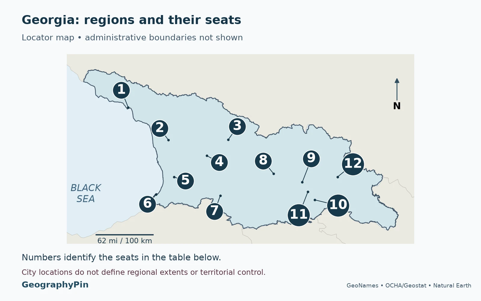
The map uses Georgia’s internationally recognized territory and the regional scheme listed by the Ministry of Economy and Sustainable Development: nine regions, two autonomous republics and the capital, Tbilisi. That produces 12 entries in the table, not 12 interchangeable provinces. The Georgian word mkhare is commonly translated as “region.”
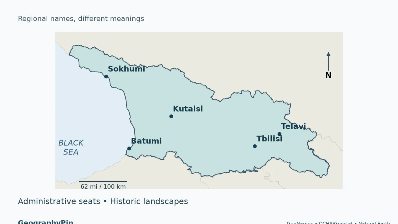
The first map locates the administrative seats rather than drawing regional boundaries. It is not a map of territorial control, municipal boundaries or cultural identities. The nine regions are not sovereign states. Municipalities form a different level of local administration; a regional seat and a municipality’s center need not answer the same question.

Names, unit types and administrative seats
| Map number and name | Type | Seat |
|---|---|---|
| 1. Abkhazia | Autonomous republic | Sokhumi (Sukhumi); see control note |
| 2. Samegrelo–Zemo Svaneti | Region | Zugdidi |
| 3. Racha–Lechkhumi and Kvemo Svaneti | Region | Ambrolauri |
| 4. Imereti | Region | Kutaisi |
| 5. Guria | Region | Ozurgeti |
| 6. Adjara (Ajara) | Autonomous republic | Batumi |
| 7. Samtskhe–Javakheti | Region | Akhaltsikhe |
| 8. Shida Kartli | Region | Gori |
| 9. Mtskheta–Mtianeti | Region | Mtskheta |
| 10. Kvemo Kartli | Region | Rustavi |
| 11. Tbilisi | Capital city, listed separately | Tbilisi |
| 12. Kakheti | Region | Telavi |
Abkhazia requires a separate reading: Sokhumi is the capital specified in the Georgian constitutional framework for the autonomous republic. This does not mean the Georgian central government administers Sokhumi. Abkhazia is outside its effective control; the territorial-control distinction is explained below.
Notice that Mestia is not the seat of the whole Samegrelo–Zemo Svaneti region, and Lentekhi is not the seat of the whole Racha–Lechkhumi and Kvemo Svaneti region. They are important centers within the Svaneti landscape, whereas the regional seats in the table are Zugdidi and Ambrolauri.
For the country’s location, neighbors and national context, use the Georgia country profile. The purpose here is narrower: to connect familiar place names to the correct regional category.
2. Why Historic Provinces Do Not Match the Map
A historic province is not simply an older spelling of a current region. Its meaning may come from a valley, a community, a former political territory or a long-used geographic name. Different periods and purposes can produce different extents. There is therefore no single timeless historic-boundary map that can replace the modern administrative framework.
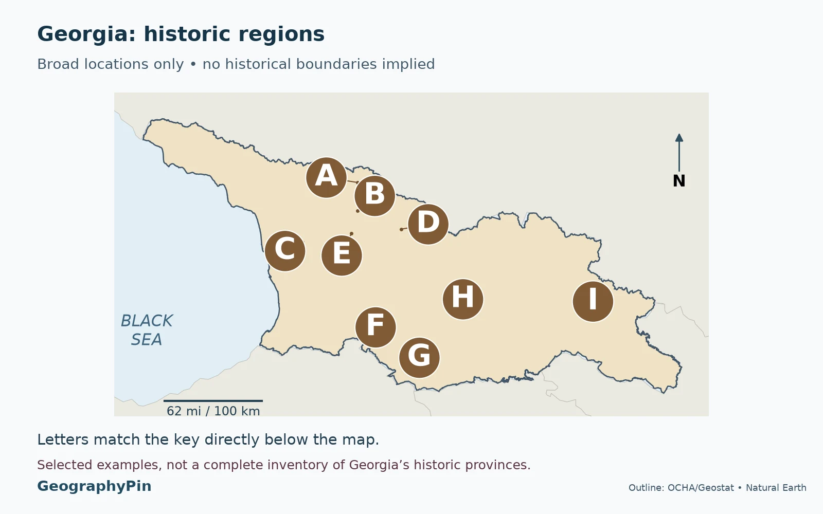
Unlike the first map’s city dots, the second map deliberately uses selected location markers rather than invented province boundaries. It answers “where should I look for this name?” It does not claim that the point is a province’s capital, a mathematical center or the limit of anyone’s identity.
| Map letter and name | Relationship to the administrative map |
|---|---|
| A. Upper Svaneti (Zemo Svaneti) | Mestia area, within Samegrelo–Zemo Svaneti |
| B. Lower Svaneti (Kvemo Svaneti) | Lentekhi area, within Racha–Lechkhumi and Kvemo Svaneti |
| C. Samegrelo | Historic region within the combined Samegrelo–Zemo Svaneti unit |
| D. Racha | Ambrolauri and Oni areas, within the Racha–Lechkhumi and Kvemo Svaneti unit |
| E. Lechkhumi | Tsageri area, within the same combined unit |
| F. Samtskhe | Historic name carried by Samtskhe–Javakheti; western part of the illustrated pair |
| G. Javakheti | Southern highland area associated with Akhalkalaki and Ninotsminda |
| H. Kartli | Broad historic name; not a single current region |
| I. Kakheti | Historic name also used for a present administrative region |
Svaneti: one historic name, two regional settings
The clearest example is Svaneti. Zemo means Upper; Kvemo means Lower. Upper Svaneti is associated with Mestia and the upper Enguri valley. Lower Svaneti is associated with Lentekhi and the Tskhenistskali valley. They are related historic landscapes, but they sit in different present-day regional units.
The Georgian National Tourism Administration places Upper Svaneti within Samegrelo–Zemo Svaneti and Lower Svaneti within Racha–Lechkhumi and Kvemo Svaneti. Reading only the first half of either long regional name loses that distinction. A reference to “Svaneti” alone is therefore not enough to select one administrative region.
Nor are Samegrelo and Svaneti synonyms. Their combination in one administrative name does not erase their different geographic and cultural associations. The guide to the Svans and Svaneti explains the cultural side without treating the regional boundary as an ethnic boundary.
Compound names combine places rather than replacing them
Racha–Lechkhumi and Kvemo Svaneti brings together three familiar names. Within it, official tourism descriptions associate Ambrolauri and Oni with Racha, Tsageri with Lechkhumi, and Lentekhi with Lower Svaneti. Those are useful connections, not a claim that a modern municipal polygon is an exact historical frontier.
Samtskhe–Javakheti similarly carries the names Samtskhe and Javakheti. A traveler reading about the Javakheti plateau is encountering a more specific landscape than the entire administrative region. The combined name is useful for administration; the individual names remain useful for history and physical geography.
Kartli shows another pattern: a broad historical name appears in Shida Kartli and Kvemo Kartli, while the modern map also distinguishes Mtskheta–Mtianeti and Tbilisi. Do not merge all four into one present-day region called Kartli. Historical use must be interpreted in its period and context.
The same name can belong to both layers
Kakheti, Imereti and Guria are examples of names used for both present regions and historic or cultural geography. That does not guarantee identical borders across every historical period. A modern administrative map is appropriate for locating Telavi within Kakheti; it cannot, by itself, establish the extent of a former kingdom.
Smaller historic areas also sit within larger modern regions. Tusheti is associated administratively with Akhmeta municipality in Kakheti, rather than being an additional region alongside Kakheti. Georgia’s UNESCO tentative-list submission describes Mta-Tusheti as a historic-geographic region. “Tentative list” is a nomination-stage category, not inscription as a World Heritage property.
For destination planning within eastern Georgia, the Kakheti travel guide serves a different purpose from this regional reference. A tourism destination, a protected area and an administrative region may share a name without sharing boundaries.
3. Recognized Territory and Actual Control
A boundary is not proof of who governs an area
Two questions must be kept separate: what territory is internationally recognized as part of Georgia, and which authorities actually exercise control there. The European Union supports Georgia’s sovereignty and territorial integrity within its internationally recognized borders. Abkhazia and South Ossetia/Tskhinvali region are outside the Georgian central government’s effective control.
The EU Monitoring Mission explains that its mandate covers Georgia but that the de facto authorities in Abkhazia and South Ossetia deny it access to the territories they control. The mission refers to the dividing lines as Administrative Boundary Lines. These should not be drawn or described as internationally recognized state borders.
Abkhazia is included among the two autonomous republics in the regional scheme used here. South Ossetia/Tskhinvali region is not added as a thirteenth equivalent unit in that scheme. It also should not be replaced by a shading of all Shida Kartli: the two geographic extents are not interchangeable.
The maps therefore retain Georgia’s recognized-territory outline but do not draw internal regional or control boundaries. A location marker is not an access or safety assessment. These maps are for geographic interpretation, not for deciding whether a road, crossing or destination is accessible.
4. Use the Right Regional Name
Choose the name that answers the task, rather than assuming the longest or oldest name is always the most accurate.
- Reading a regional table: use the full administrative name and check its coverage note. A statistic for Samegrelo–Zemo Svaneti is not automatically a statistic for Svaneti alone.
- Reading a cultural description: keep the historic name, but locate it within the modern framework when that helps the reader. “Lower Svaneti, in the Lentekhi area” conveys more than “Svaneti” when the distinction matters.
- Finding a government office: distinguish the regional administration from a municipal authority. A well-known local town is not necessarily the seat of the whole region.
- Planning an itinerary: use the actual settlement and route as well as the regional label. A regional boundary cannot tell you the drive time between two valleys.
Spelling variations can be less significant than category differences. Adjara and Ajara refer to the same autonomous republic in common English usage; Sokhumi and Sukhumi are alternate forms of the same city name. By contrast, Samegrelo and Samegrelo–Zemo Svaneti do not have the same scope. Keep the full compound name when discussing the administrative unit.
As a practical check, take any place name and ask: is this a city, a current region, an autonomous republic, a historic landscape or a protected area? Then ask whether the source means recognized territory or government-covered territory. Those two checks prevent many of the apparent contradictions between maps and travel writing.
Frequently Asked Questions
Does a regional seat have to be the region’s largest city?
No. “Seat” identifies the administrative center; “largest” is a population comparison requiring a dated and consistently defined dataset. The table lists seats and does not rank cities by size.
Can a historic region extend beyond today’s national borders?
Yes. Historical territories must be read in their own period rather than assumed to fit modern state borders. The locator map here is deliberately limited to selected names within present-day Georgia; it does not reconstruct every historical province or past territorial extent.
Is this map suitable for legal property or municipal-boundary decisions?
No. It is a small-scale regional reference derived from generalized boundary data. Property, jurisdiction and boundary disputes require the relevant official records, not a national overview map.
What Did We Learn Today?
A useful Georgia regions map tells you what kind of geography it represents. Administrative names organize present regional references, historic names describe a different layer, and territorial control needs its own explanation. Svaneti shows why the distinction matters: Upper and Lower Svaneti share a historic connection while belonging to different modern regions. Reading the full name, the unit type and the map’s coverage is more reliable than treating every familiar place name as an equivalent province.
Sources & Data Notes
The maps use the country outline from OCHA/Geostat’s administrative-boundary dataset, with a source validity date of October 18, 2019. Internal regional boundaries are intentionally not drawn. Administrative seats use GeoNames populated-place coordinates, not region centroids; the maps locate places rather than certify present legal boundaries. GeographyPin reprojected the outline and added styling, symbols and labels. The historic-region map uses broad label locations informed by official tourism descriptions, not measured historical boundaries; its selected names are not an exhaustive inventory.
- Ministry of Economy: National Spatial Development Concept, terms of reference, regional framework, page 4.
- Constitutional Court: Constitution of Georgia, national capital and constitutional framework.
- Matsne: Constitution of the Autonomous Republic of Abkhazia, capital; the linked English text is a published edition, not a statement of territorial control.
- Matsne: On the Approval of the Constitution of the Autonomous Republic of Ajara, administrative center; regional-seat cross-checks also used Georgian regional authorities and official tourism descriptions.
- Georgia Travel: Samegrelo–Zemo Svaneti, Racha–Lechkhumi and Kvemo Svaneti, and Samtskhe–Javakheti, historic-name crosswalk.
- UNESCO: Mta-Tusheti tentative-list submission, geographic description and administrative location.
- EU Monitoring Mission: mandate, territorial access and Administrative Boundary Lines; EU statement on the conflict in Georgia, recognized borders and effective control.
- OCHA/Geostat: Georgia administrative boundaries, country outline, CC BY 3.0 IGO; GeoNames country gazetteer, city points, CC BY 4.0; Natural Earth, public-domain surrounding land. These are adapted locator maps, not reproductions of an official regional-boundary map.