Quito is Ecuador’s capital in the Andes of northwestern South America. Its historic center lies just south of the Equator, on the eastern side of the Pichincha volcanic complex. The city is high above sea level, but its wider metropolitan district includes much more than the continuous urban area, extending across contrasting mountain and rural landscapes.
How to use this article: Locate Quito relative to the Equator, interpret its elevation, and distinguish city and district.
1. Locate Quito within Ecuador
An Andean capital, not a coastal city
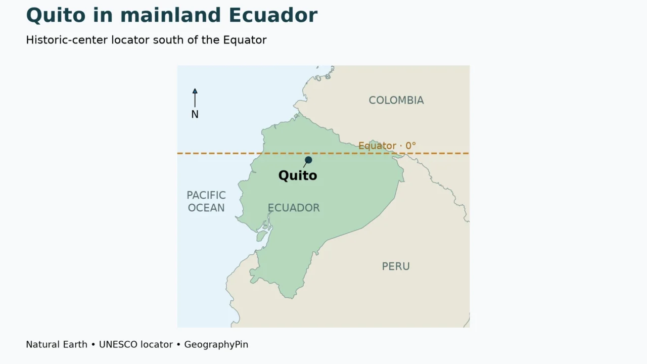
Quito belongs to Ecuador’s mountainous interior. The Pacific coast lies to the west, while the Andes provide the physical setting around the capital. On a map of mainland Ecuador, Quito appears in the northern part of the country, close to the Equator rather than close to the coastline.
This setting helps explain why “equatorial city” and “hot coastal city” are not interchangeable descriptions. Latitude tells you where a place sits north or south of the Equator. Elevation tells you how high it stands above a vertical reference such as sea level. Quito combines a near-equatorial latitude with a high Andean location.
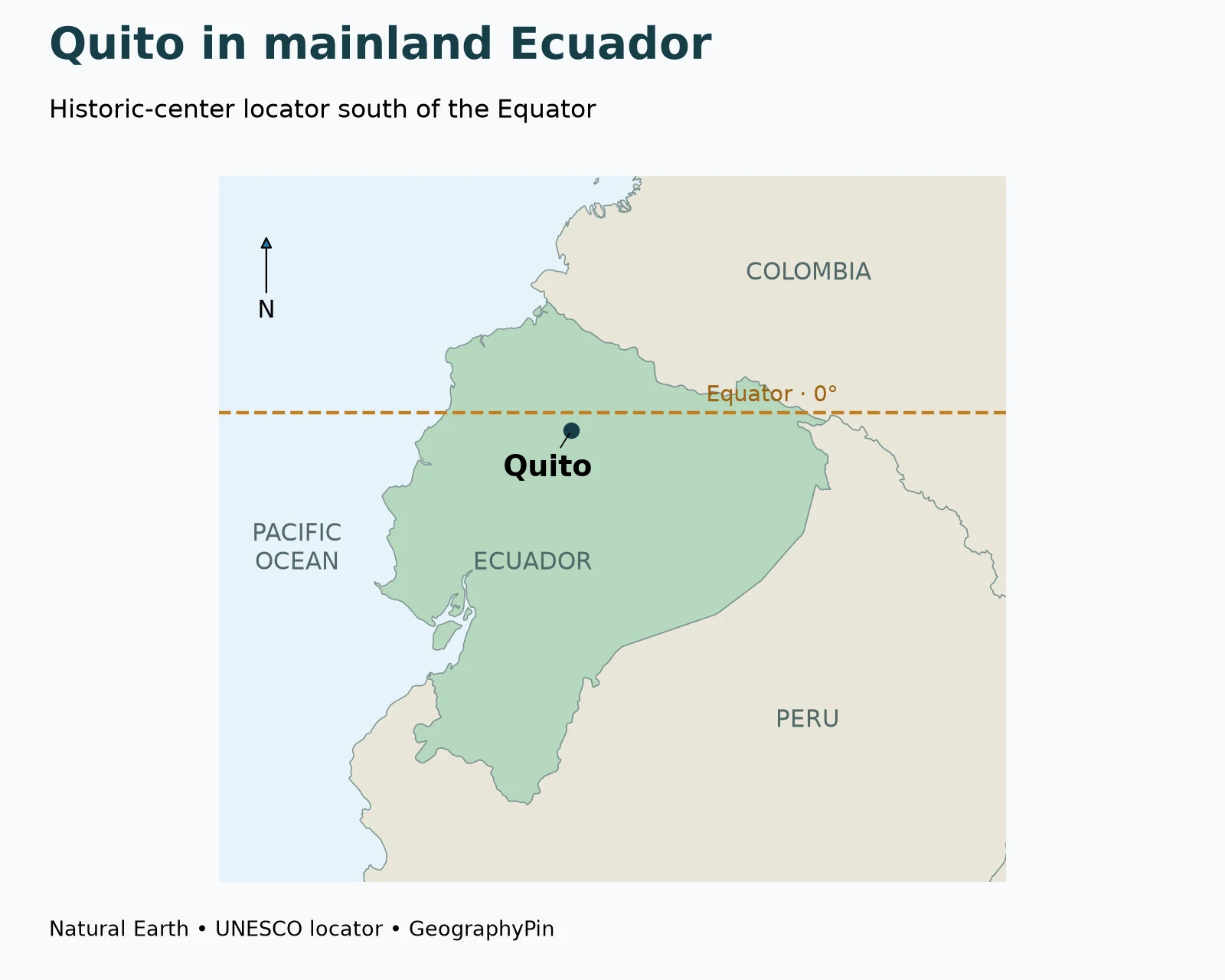
For the regional country context, see GeographyPin’s South American countries and capitals. The separate countries on the Equator guide explains why Ecuador belongs in the land-crossing list without implying that every Ecuadorian city sits on zero latitude.
2. Is Quito actually on the Equator?
The historic center is south of zero latitude
Quito’s close association with the Equator can make “on the Equator” sound like a precise address. For the historic center, it is not. UNESCO’s reference point for the City of Quito World Heritage property is at 0°13′12″ south, equivalent to 0.22° south latitude.
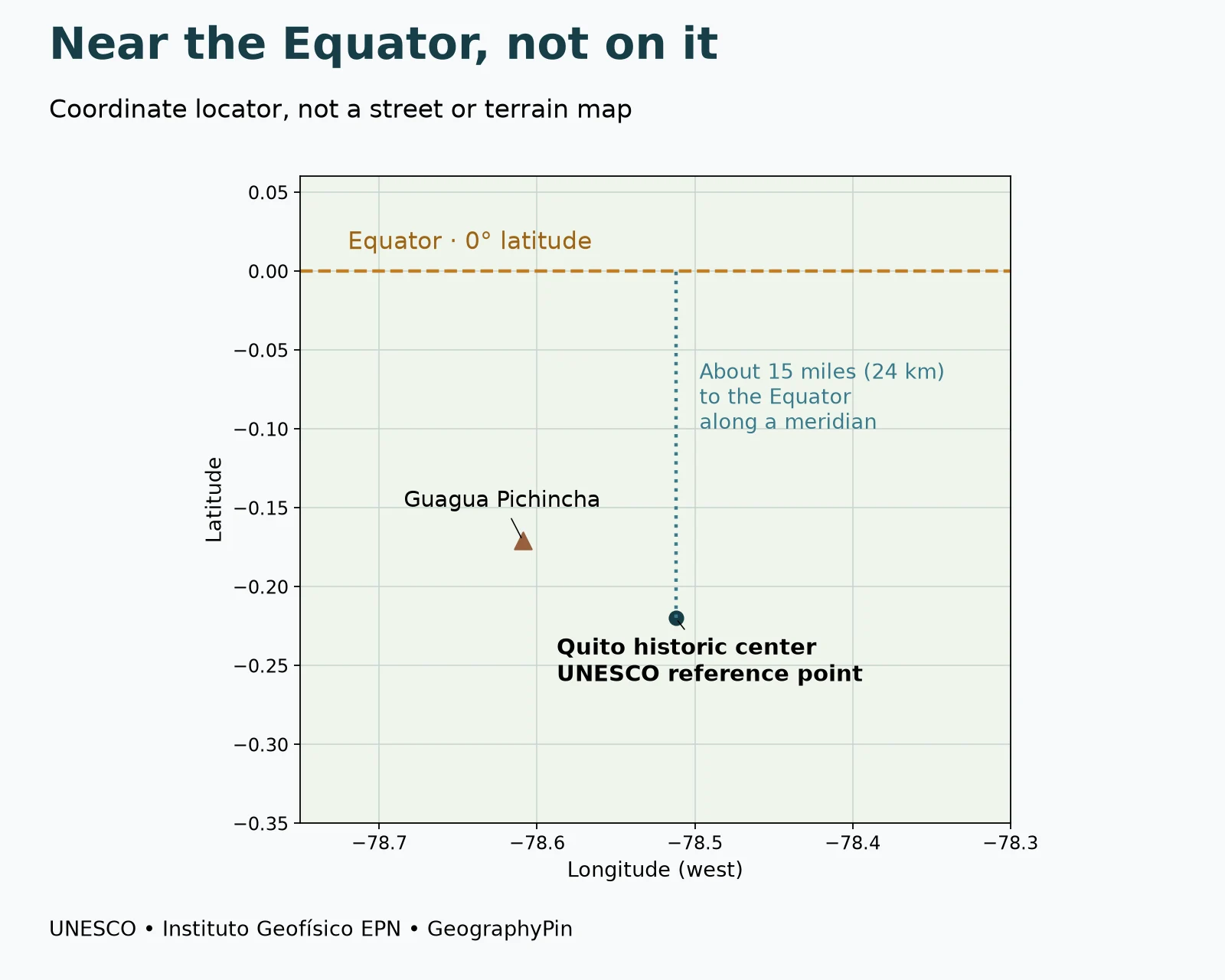
Using that published latitude, the distance north to the Equator along the same meridian is approximately 15 miles (24 kilometers). This is a calculated geographic separation, not a driving distance, a walking route or the distance from every neighborhood. The map below uses the same UNESCO reference point so the comparison is reproducible.
A reference point is not a city boundary
A coordinate identifies a point. A city, district or heritage property occupies an area. These are different types of geographic information, and confusing them produces apparently contradictory claims.
The UNESCO locator establishes that the historic-center reference point is south of the Equator. It does not establish the latitude of every place marketed as part of Quito, nor does it define the perimeter of the metropolitan district. A visitor attraction using an equatorial theme is also a different location from the historic center.
When someone says Quito is “at the middle of the world,” read it as a broad association unless they specify the place and coordinate. To test an exact claim, ask whether it concerns the old city, a particular monument, a neighborhood or the larger administrative territory.
Latitude and longitude should not be swapped
The same UNESCO point is approximately 78.5121° west longitude. The south value measures position relative to the Equator; the west value measures position relative to the prime meridian. The two numbers describe different directions.
The local locator plots latitude vertically and longitude horizontally. The dashed horizontal line is 0° latitude. Quito’s point lies below that line, while Guagua Pichincha is west of the Quito reference point. The diagram shows positions, not a terrain surface, road route or hazard zone.
3. How high is Quito?
Use an approximate city reference, not one height for every street
UNESCO’s introductory description places Quito at about 9,350 feet (2,850 meters) above sea level. This is a useful general reference for its high-altitude setting, not a claim that the whole city forms a flat platform at precisely that height.
For a particular address, hill or viewpoint, use a location-specific elevation source. Slopes, hills and valleys mean that a single city-level figure cannot describe every street.
Near-equatorial does not mean low-lying
Latitude and elevation are independent coordinates. Moving toward the Equator does not automatically move a place down to sea level, just as moving north does not automatically place it on a mountain.
Quito is a memorable example because these two properties are easy to separate on a map. Its latitude is close to zero, yet its elevation is far above the Pacific coast. The regional locator shows its position within the country; an elevation reference adds information that a flat political map cannot supply by itself.
4. Pichincha and the city’s mountain setting
Separate the volcanic complex from the historic-center locator
Quito’s urban landscape lies on the eastern side of the Pichincha volcanic setting. Ecuador’s Instituto Geofísico identifies Guagua Pichincha west of Quito and publishes a reference coordinate of 0.171° south, 78.609° west. That coordinate supplies the volcanic locator on the diagram.
Guagua Pichincha is not another name for Quito’s city center. Likewise, a label reading “Pichincha” can refer to a wider geographic context than a single point. Keeping the city and volcanic reference locations separate helps prevent a map from placing the capital on the summit.
The Instituto Geofísico describes older centers, including Rucu, east of Guagua Pichincha. The volcanic complex is therefore not adequately represented by imagining one isolated cone with the whole city directly beneath its summit.
A north–south city and growth toward the valleys
Quito’s metropolitan development plan describes an elongated urban form. Its account of the Metro gives a concrete way to picture that geography: the line runs through the consolidated urban area from Quitumbe in the south, through the historic center near San Francisco, toward El Labrador in the north. These places form an urban sequence, not a ring around a single central point.
The same plan identifies expansion toward valley areas, naming Pomasqui, Tumbaco and Los Chillos. The capital’s geography therefore includes both the long established urban axis and development beyond it. A map restricted to the historic center cannot explain the whole metropolitan pattern.
This relationship matters when comparing descriptions of Quito: a central-city journey and a connection to a valley concern different parts of the urban system. The municipal development plan provides the planning context; it is not a live timetable or a promise about journey times.
UNESCO also describes historic architecture adapted to complex topography. Terrain helps explain Quito’s uneven landscape, while transport, land use and historical development help explain how people connect and occupy it.
The locator here is not a volcanic-risk map. It does not assess current activity, predict an eruption or identify safe travel routes. Those require the appropriate current monitoring and official hazard information from Ecuadorian authorities.
5. Quito city and the Metropolitan District are not the same footprint
Urban and rural land belong to different spatial descriptions
The Metropolitan District of Quito is a larger administrative territory than the continuous built-up city. Municipal planning materials explicitly distinguish urban and rural land and organize information about protected areas, development and different urban centers within that territory.
This matters whenever a statistic is introduced as “Quito’s population,” “Quito’s area” or “Quito’s biodiversity.” Before comparing it with another city, identify the geographic unit. A district total should not be compared casually with a historic-center figure or the population of a tightly defined built-up area.
| Label | What it describes | What it should not be confused with |
|---|---|---|
| Historic center | A particular part of the city with a heritage context | Every neighborhood or all district territory |
| Built-up urban area | The physically developed city landscape under a chosen definition | A municipal boundary by default |
| Metropolitan District | An administrative territory including urban and rural settings | One continuous block of buildings |
| Quito reference coordinate | A specified locator point | An outline of any of the above |
A wider district can include very different environments
A municipal account of the district’s environmental setting describes a transition between the Chocó and Andes, including lower-elevation forests and high Andean páramo. That range belongs to the wider territory, not to every downtown street.
The distinction makes the geography more interesting, not less. A high historic center and lower rural environments can belong to the same administrative district. It is the boundary and the definition of the unit that allow them to be discussed together.
When reading a map or a statistic, begin with three questions: Which part of Quito is being described? Is the information a point, a boundary or a measured surface? And does the date matter for this particular claim? Those questions prevent common errors without requiring a reader to memorize every local administrative name.
Frequently Asked Questions
Is Quito on the Equator?
Its historic-center UNESCO reference point is south of the Equator, at 0.22° south. Broad associations with the equatorial region should not be confused with an exact coordinate.
How far is Quito from the Equator?
From the UNESCO historic-center reference point, northward separation along the same meridian is about 15 miles (24 kilometers). Driving distances and distances from other neighborhoods are different.
What is Quito’s elevation?
UNESCO gives about 9,350 feet (2,850 meters) as a general reference. Elevation varies across the city and wider district.
Is Quito a coastal city?
No. It lies in Ecuador’s Andean interior, east of the Pacific coast.
Is the Metropolitan District the same as the built-up city?
No. The administrative district includes urban and rural settings. Its area and statistics should not be treated as identical to those of the continuous urban area.
What Did We Learn Today?
Quito combines a near-equatorial position with a high Andean setting. Its historic center is south of zero latitude, its elevation is not identical across every street, and its wider metropolitan district contains more than the built-up city. Separating location, height and administrative scope makes maps and statistics about Ecuador’s capital easier to interpret.
Sources & Data Notes
The city locator follows UNESCO’s published property reference point, not an independently surveyed city center or boundary. Its latitude converts to 0.22° south. Northward distance to 0° along that meridian is approximately 24.33 kilometers on the WGS84 ellipsoid, rounded to 15 miles (24 kilometers). This is not a road distance.
- UNESCO: City of Quito: reference coordinate, general elevation and historic landscape.
- Instituto Geofísico EPN: Guagua Pichincha: volcanic setting and reference coordinate.
- Quito Informa: urban and rural land-use planning: Metropolitan District scope.
- Quito Informa: district environmental diversity: Chocó–Andes landscape range. Promotional rankings and species totals are not used here.
- Quito Metropolitan Development and Territorial Plan 2024–2033: elongated urban structure, north–south Metro axis and expansion toward valleys.
- Natural Earth: public-domain data: country geometry.
Map method: Original GeographyPin maps use Natural Earth 1:10m country polygons and the UNESCO locator in WGS84/UTM zone 17S projection. The local figure is a latitude–longitude coordinate plot with the Instituto Geofísico’s Guagua Pichincha point and a 0° latitude line. No municipal boundary, built-up footprint, terrain surface or hazard zone was invented. The country map is a mainland locator, not a complete map of Ecuador’s offshore territory.
Elevation: The 2,850-meter reference is approximate and converted to a rounded 9,350 feet. It does not assign the same height to all neighborhoods or district territory. No current eruption, weather or travel-safety assessment is made.