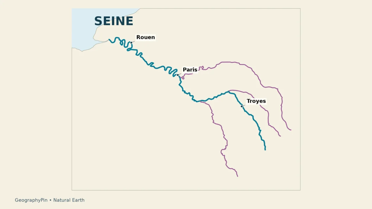
Paris is the Seine’s most familiar setting, but it is only one part of a much larger river system. Upstream lie the Burgundy headwaters and tributary valleys; downstream, broad bends lead through Normandy toward a tidal estuary and the English Channel. Following that sequence makes the river much easier to understand than starting with a photograph of a Paris bridge.
The Seine flows through northern France from Source-Seine in Burgundy, through Troyes and Paris, then past Rouen to the English Channel between Le Havre and Honfleur. Its course is roughly 480 miles (770 km). Major tributaries include the Yonne, Marne and Oise; its tidal estuary begins downstream at Poses.
1. Source, route and mouth
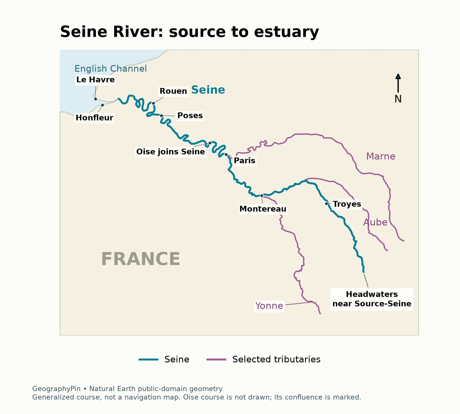
The named source is in the commune of Source-Seine, in Côte-d’Or, Burgundy. From this upland setting the river heads through eastern and northern France, reaches Troyes, and continues toward the Paris region. Its overall journey is toward the northwest, although individual bends repeatedly change direction.
| Part of the journey | Place to recognize | Geographic meaning |
|---|---|---|
| Headwaters | Source-Seine, Burgundy | The named source, well outside Paris |
| Upper river | Troyes | The Seine before the major Paris-region confluences |
| Yonne confluence | Montereau-Fault-Yonne | A major tributary joins upstream of Paris |
| Capital region | Paris | An urban reach, not the source or mouth |
| Lower river | Poses and Rouen | The transition into the tidal estuary |
| Mouth | Le Havre and Honfleur | The estuary opens into the English Channel |
The mouth is an estuarine opening rather than a single city-center point. Le Havre and Honfleur sit on opposite sides of this lower coastal setting. Saying that the river “ends in Paris” confuses its best-known city with its destination.
How long is the Seine?
A practical rounded answer is about 480 miles (770 km). The City of Paris uses 777 km, while the water agency’s basin overview gives 773 km and another agency explainer gives 777 km. These small differences reflect published reference figures; they are not evidence of a recent change in the river’s length.
2. Tributaries and confluences
Yonne, Marne and Oise: three different connections
A tributary is another river feeding the main river. The place where they meet is a confluence. The water agency identifies the Yonne, Marne and Oise as the Seine’s principal tributaries, but they do not all enter it at Paris or on the same side of the city.
- Yonne: joins the Seine at Montereau-Fault-Yonne, upstream of Paris. Its catchment extends into the Morvan.
- Marne: joins near Charenton-le-Pont and Alfortville, just upstream of central Paris. Its winding route approaches from the east.
- Oise: joins at Conflans-Sainte-Honorine, downstream and northwest of Paris. Its headwaters are in Belgium, although the Seine’s main stem itself lies in France.
Other tributaries include the Aube and Loing upstream of the Paris region, and the Eure and Risle farther downstream in Normandy. These names describe branches of a network, not alternative names for the Seine. A river can remain the named main stem after receiving a substantial tributary.
The map includes only selected tributaries so that the main route stays legible. It should not be used to infer that an unshown river is absent. For the underlying vocabulary, see what a river is and how its parts connect.
3. The Seine at Paris
The Seine crosses Paris between the Marne confluence upstream and the Oise confluence downstream. This places the capital within a continuing river corridor, rather than at a hydrological endpoint. Water passing a central Paris bridge has already collected from a large upstream network and still has a long journey to the coast.
The City of Paris describes about 8 miles (13 km) of river within the city. That urban segment is only a small fraction of the full course. Its bridges, quays and islands provide familiar landmarks, but a city map cannot show the catchment supplying the river.
“Left Bank” and “Right Bank” are defined by looking downstream, not by whichever side happens to appear on the left of a photograph. On the broadly westward central Paris reach, the Left Bank lies generally to the south and the Right Bank generally to the north. The downstream convention is the reliable rule when bends make a compass shortcut confusing.
A river’s water level is not the same thing as its depth everywhere across the channel. A gauge measures height relative to a local reference; channel-bed elevation and cross-section determine depth. Our guide to reading river gauges explains why a number on a gauge should not be treated as a universal swimming depth or flood threshold.
4. Rouen and the tidal estuary
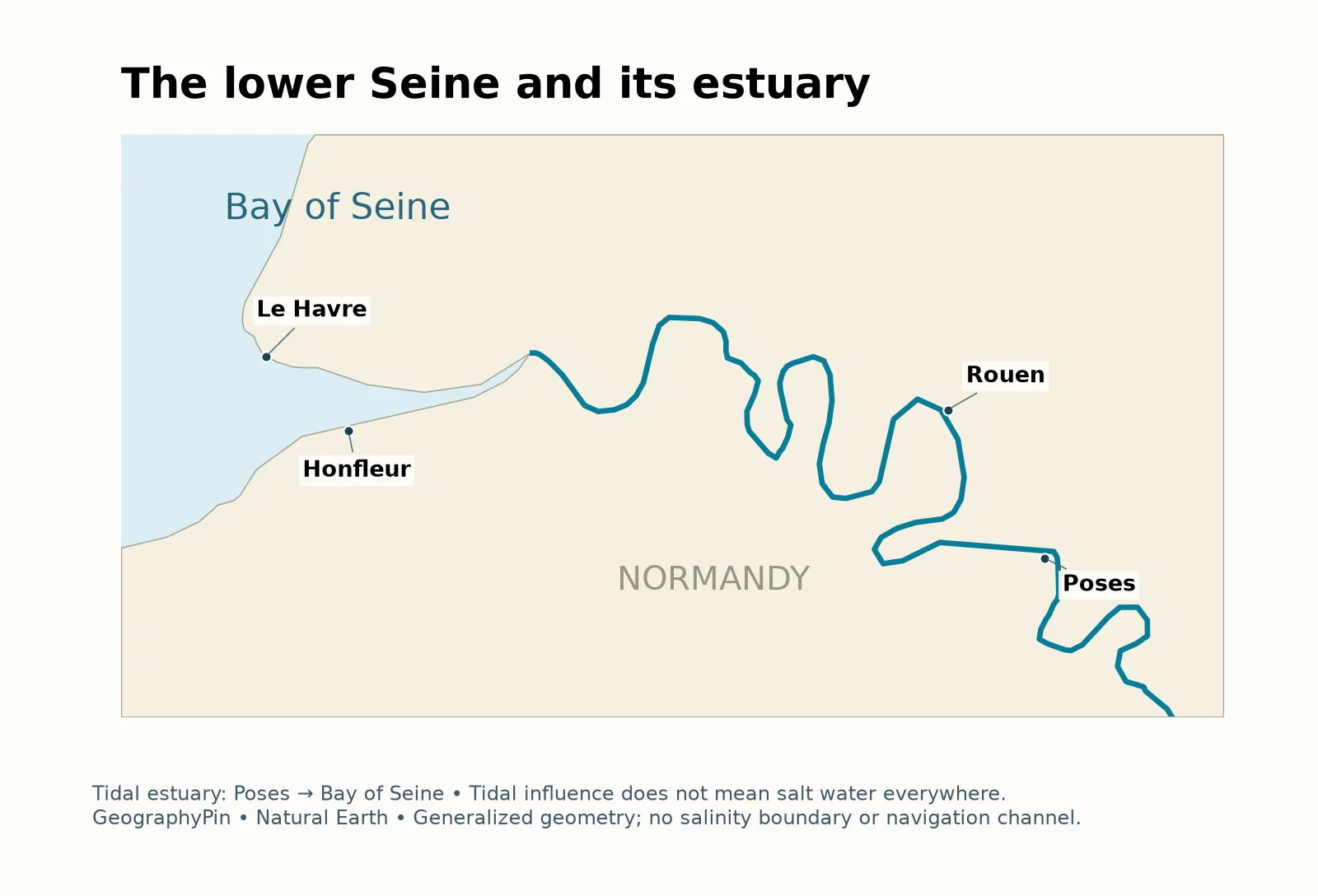
GIP Seine-Aval defines the estuary as the final roughly 106 miles (170 km), from the barrage at Poses to the Bay of Seine. That definition includes riverbanks, connected wetlands and the marine area at the mouth. Rouen lies within this lower, tidal part of the system, not on the open coast.
Tidal does not mean salty everywhere
The upper estuary can be influenced by tides while its water remains fresh. Farther downstream, fresh and marine waters mix; nearer the sea the marine influence dominates. Tidal motion and salinity are related processes, but they are not interchangeable labels. A map that colors the entire Poses-to-sea reach as salt water would therefore mislead readers.
Paris lies upstream of the Poses limit used in this estuary definition. A changing water level at Paris should not automatically be described as the sea tide reaching the capital. The river’s flow, rainfall, operations and gauge context need to be considered instead.
The lower corridor also explains the relationship between its ports. HAROPA PORT brings together Le Havre, Rouen and Paris in a single river-and-sea port system. Their locations serve different roles along the coast-to-inland connection; they are not three names for the same harbor.
5. River, basin and water-management district
Three maps can describe three different things
The river is the named channel and its flowing water. The drainage basin is the land draining toward that river system. The Seine–Normandie management district includes the Seine system and additional coastal rivers of Normandy. These are related geographic units, not identical outlines.
This distinction matters when comparing statistics. The water agency’s overview lists about 36,500 square miles (94,500 km²) for the wider Seine–Normandie district. That is not the area of the Seine’s drainage basin alone. Its own pages give differing approximate basin figures, so a precise comparison should preserve the source’s geographic scope instead of silently substituting one total for another.
An upstream event can affect places downstream even if they are far apart on the road network. Water moving through tributaries connects rural areas, towns and the metropolitan region. This is why river planning often follows drainage systems rather than only municipal boundaries.
6. A river shaped by people and water
The Seine is not an untouched channel. Its navigated reaches, developed banks and upstream reservoirs are part of the geography readers see today. Understanding the network requires both the physical river and the infrastructure managing parts of its flow.
Seine Grands Lacs operates four reservoir systems associated with the Seine, Marne, Aube and Yonne. Its overview distinguishes Pannecière, built directly on the Yonne, from the Seine, Marne and Aube reservoirs connected through diversion canals. Their purposes include reducing winter flood peaks and supporting river flow in dry periods.
These reservoirs moderate flows, but they do not eliminate flood risk or regulate every tributary.
For a reader looking at the Seine on the ground, three questions are especially useful: Which tributaries have joined upstream? Is this reach above or below Poses? And does the map show the river itself, its catchment, or a wider management area? Those distinctions turn a familiar name into a coherent geographic system.
Frequently Asked Questions
Where does the Seine begin and end?
It begins at Source-Seine in Burgundy and reaches the English Channel through its estuary between Le Havre and Honfleur. Paris is an intermediate city on the route.
Does the Seine flow through Paris and Rouen?
Yes. Paris is upstream of Rouen. Following the river downstream takes you from the Paris region into Normandy and toward the estuary.
Which tributaries join before and after Paris?
The Yonne and Marne join upstream of central Paris. The Oise joins downstream at Conflans-Sainte-Honorine.
Is the Seine estuary all salt water?
No. The upper estuary includes fresh water affected by tides. Tidal influence should not be confused with a saltwater boundary.
Is the Seine only a French river?
Its named main stem lies in France. Its wider drainage network is not confined in exactly the same way: the Oise begins in Belgium.
What Did We Learn Today?
The Seine connects Burgundy, Paris and Normandy before reaching the English Channel. Its tributaries join at different points, and the tidal estuary begins downstream at Poses rather than in Paris. The river channel, its drainage basin and the wider Seine–Normandie district are different geographic units; keeping them separate prevents misleading maps and statistics.
Sources & Data Notes
- Agence de l’Eau Seine-Normandie: basin overview: source, mouth, tributaries, confluences and management-district scope.
- Water agency: the Seine under climate change: alternative published length and basin figures, used with the scope distinction above.
- City of Paris: La Seine, cœur battant de Paris: city reach and published total length.
- GIP Seine-Aval: where the estuary begins and ends: Poses-to-bay definition and tidal freshwater distinction.
- Conflans-Sainte-Honorine municipal history: Seine–Oise confluence and its position northwest of Paris.
- Seine Grands Lacs: four reservoir systems: reservoir configuration and purposes.
- HAROPA PORT: organization: Le Havre–Rouen–Paris port corridor.
- Natural Earth river data and public-domain terms: actual generalized river and land geometry, styled by GeographyPin.
Map method: select the named Seine, Marne and Yonne line features and the Aube from Natural Earth’s European supplement; clip the public-domain land layer for coastal context. Rounded city/locality markers are orientation aids, not exact riverbank coordinates.