A mountain pass is a lower crossing through a ridge, not necessarily a road. In Georgia, confusing the landform with a highway, a tunnel or a hiking route can change the meaning of a map completely.
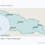
Georgia’s mountain passes connect valleys and regions across its ridges: Nakerala links Imereti with Racha, Goderdzi links Adjara with Samtskhe-Javakheti, and Datvisjvari links the Aragvi and Arghuni sides of Khevsureti. The map distinguishes road-pass locations from border saddles and a documented footpath. None of its symbols confirms present-day access.
Find the connection you need: Start with the map’s selection rule, compare Jvari with an international crossing, or use the local terrain profiles before checking official access notices.
1. Read the Georgia Mountain Passes Map
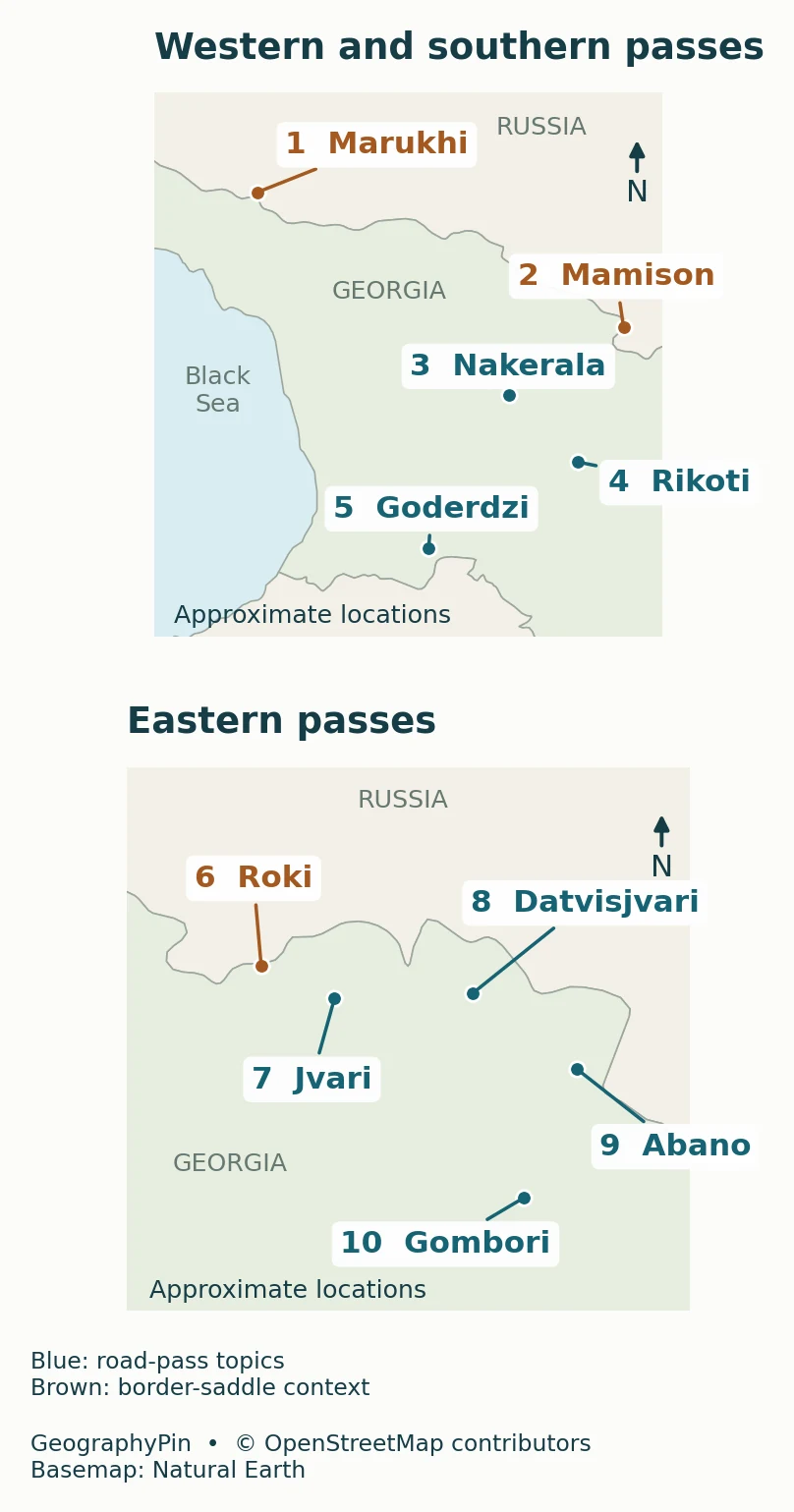
Open the larger map · Open the stacked map
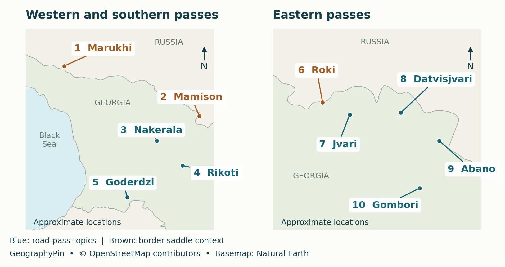
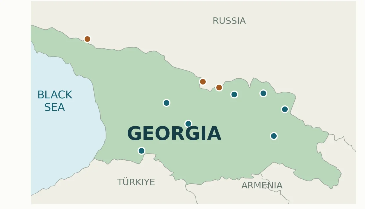
Map key: 1 Marukhi; 2 Mamison; 3 Nakerala; 4 Rikoti; 5 Goderdzi; 6 Roki; 7 Jvari; 8 Datvisjvari; 9 Abano; 10 Gombori. These are reference numbers, not a ranking or a suggested journey.
Why these ten passes?
The selection illustrates three distinct functions: seven road-pass connections discussed in Georgian tourism or reference sources, one documented footpath connection at Marukhi, and two other northern border saddles, Mamison and Roki. It is not a complete inventory of Georgia’s passes or a list of its ten highest crossings. Chaukhi appears below as a further walking example, without an unverified map point.
The dots reproduce named OpenStreetMap source locations at a broad reference scale. Geographic connections were checked against Georgian reference sources, and terrain-elevation context was screened with NASA/USGS SRTM data accessed through OpenTopoData. These checks support broad orientation, not independently surveyed saddle positions. Abano’s exact location and height remain particularly uncertain; its marker identifies the general road-pass area, not a verified saddle. Generalized country outlines can also diverge from the local ridge near a border. Use the map to understand relative location, not to choose a trail, approach a border or navigate to a saddle.
Original cartography: GeographyPin. Pass data: © OpenStreetMap contributors; basemap: Natural Earth, public domain. The downloadable source extract retains source IDs and ODbL attribution. Download the map’s source points and road traces (GeoJSON ZIP, © OpenStreetMap contributors, ODbL 1.0).
2. Road Passes, Footpaths and Border Saddles
“Road pass” identifies a geographic connection associated with a road. It does not promise a paved surface, a suitable rental-car route or an open road. Likewise, a historical footpath is evidence of a connection across the ridge, not permission to walk it today.
| Pass | Geographic connection | How to interpret it |
|---|---|---|
| 1. Marukhi | Chkhalta valley ↔ Marukha valley | Documented footpath; border context, not a road itinerary |
| 2. Mamison | Chanchakhi/Rioni drainage ↔ Ardon/Terek drainage | Border saddle; not presented as an available crossing |
| 3. Nakerala | Imereti ↔ Racha | Road pass on the Tkibuli–Ambrolauri connection |
| 4. Rikoti | Shida Kartli ↔ Imereti | Surface pass distinct from the tunnel corridor |
| 5. Goderdzi | Adjara ↔ Samtskhe-Javakheti | Road pass on the Batumi–Akhaltsikhe connection |
| 6. Roki | Southern ↔ northern side of the Greater Caucasus | Surface saddle distinct from the Roki Tunnel |
| 7. Jvari | Aragvi side ↔ Tergi side in Khevi | Georgian Military Road pass within Georgia |
| 8. Datvisjvari | Aragvi side ↔ Arghuni side in Khevsureti | Road pass toward the Shatili side |
| 9. Abano | Stori valley ↔ Tushetis Alazani valley | Pass associated with the approach to Tusheti |
| 10. Gombori | Outer Kakheti ↔ Inner Kakheti | Road pass across the Gombori Range |
The map does not connect these points with a line because that would suggest a usable route through them. Their shared category is a landform, not a transport network.
3. What the Eastern Crossings Connect
Jvari: across a ridge, not across the border
Jvari, also called Cross Pass, belongs to the Georgian Military Road corridor between the Aragvi side and the Tergi side around Khevi. Crossing the pass is not the same as entering Russia. Keep three locations separate: the ridge crossing, the settlements along the road, and the international checkpoint farther along the corridor.
A stay at Gudauri and onward travel toward Stepantsminda and the Kazbegi valleys therefore need separate road-section checks. Access to a resort on one side does not establish access through the pass.
Abano and Datvisjvari: different northern valleys
The Georgian Encyclopedia describes Abano as connecting the Stori valley with the Tushetis Alazani valley. Datvisjvari connects the Aragvi and Arghuni sides of Khevsureti. Those are different crossings serving different valley systems; “a road into the Caucasus” is too vague to identify either one.
The distinction also prevents a naming trap. The Tushetis Alazani is the river named in the Abano connection, not an instruction to follow the broad Kakheti Alazani valley directly across the mountains. Match the full river name and the correct side of the ridge before interpreting a route description.
Gombori: a connection within Kakheti
Gombori crosses the Gombori Range between Outer and Inner Kakheti. Its role is different from the high Greater Caucasus crossings: the useful comparison is between two parts of Kakheti, rather than between Georgia and a neighboring country.
This is why a countrywide pass map needs the connection table. Two points can both represent road passes while linking very different scales of place: neighboring valleys, historical regions or opposite sides of a major range.
4. Western and Southern Connections
Rikoti, Nakerala and Goderdzi
Rikoti is the east–west connection across the Likhi ridge between Shida Kartli and Imereti. A tunnel can carry traffic beneath a divide without passing over the surface saddle. On this map the point refers to the named pass, not to a tunnel entrance or the full modern highway corridor.
Nakerala provides the Imereti–Racha connection on the Tkibuli–Ambrolauri road. Goderdzi belongs to the Batumi–Akhaltsikhe connection between Adjara and Samtskhe-Javakheti; the Georgian Encyclopedia places it on the Arsiani Range. The regions in these descriptions are the geographic destinations, not claims that the whole road can presently be driven.
Marukhi, Mamison and Roki need a different reading
Marukhi’s documented footpath links the Chkhalta valley on the Abkhazia side with the Marukha valley in Karachay-Cherkessia. Mamison is a divide between the Chanchakhi, in the Rioni drainage, and the Ardon, in the Terek drainage. These descriptions explain which sides meet at the mountain crest; they do not establish a permitted cross-border route.
Roki is another northern saddle, separate from the Roki Tunnel. Its surface-pass symbol must not be read as a road entrance. For all three brown markers, stop at the geographic interpretation unless a separate, authoritative access check establishes what is lawful and feasible.
Abkhazia and South Ossetia are within Georgia’s internationally recognized territory but outside Tbilisi’s effective control. Their access issues cannot be represented by an ordinary country-outline map. The UK government’s regional guidance warns against travel to both and explains the legal problem with entering Georgia through them from Russia. The map is not an alternative to that advice.
5. Local Terrain Profiles and Valley Connections
Two terrain profiles across local pass approaches
These profiles sample a satellite-derived elevation model along mapped surface-road traces on both sides of Goderdzi and Rikoti. They show local approaches across a ridge, not complete river valleys. Neither is a field-surveyed road profile: the model can include vegetation and other surface effects, and it cannot resolve every road cut, bridge or small saddle.


How to read the profiles: Distances follow the mapped lines horizontally, not the slope length. Samples are approximately 330 feet (100 m) apart, with additional endpoint and pass samples. Heights use the model’s EGM96 vertical reference. The two charts use different horizontal and vertical scales and exaggerate relief; do not compare their apparent slopes or use them to estimate driving grades. One mile equals approximately 1.61 km, and 1,000 feet equals approximately 305 m. The traces do not establish present access or road condition.
Other valley connections remain conceptual: Datvisjvari links Aragvi-side and Arghuni-side Khevsureti; Abano links the Stori and Tushetis Alazani sides; Mamison links Chanchakhi/Rioni and Ardon/Terek drainage; and Marukhi links the Chkhalta and Marukha valleys. These statements do not imply equal heights or navigable routes. The two new profiles do not resolve Abano’s conflicting published heights.
Chaukhi: the walking example beyond the locator
Georgia’s tourism board describes a walking route from Juta across Chaukhi Pass toward the Abudelauri Lakes and Roshka. This is a useful domestic example of a connection that should not be classified as a through-road. A walk toward the massif’s foothills is also not the same undertaking as crossing the pass.
Chaukhi is discussed here without an additional dot because its precise pass position has not been established to the same source-record standard as the mapped set. Its route description supports the connection, not a new coordinate or a difficulty guarantee. Use the tourism board’s route page as background, then obtain route-specific conditions before planning a crossing.
Why the map does not rank pass heights
Published elevations disagree for several passes, especially Abano, Jvari and Mamison. The discrepancy cannot safely be resolved by choosing the most repeated figure or averaging the sources. A terrain model’s grid-cell height, a mapped point’s elevation and a surveyed saddle height are not interchangeable measurements.
There is stronger agreement for some individual features: the Georgian Encyclopedia gives Goderdzi as about 6,644 feet (2,025 meters) and Gombori as about 5,315 feet (1,620 meters). Those reference values are not a consistent national height-ranking dataset. These are attributed reference values, not surveyed heights verified by this map. No exact elevations are placed on the locator, and no unsupported explanation is offered for the conflicting figures elsewhere.
6. Check Access Separately from Geography
Read the latest notice for the actual route
Use the Roads Department of Georgia’s restriction notices for road access. Check the named section, date, vehicle category and any conditions attached to a reopening. A notice for trucks may not describe passenger-car access, and a notice for one branch road may not describe the through-route.
- Identify the landform: is the name a pass, tunnel, resort or mountain?
- Identify the connection: which valleys or regions are on the two sides?
- Identify the route: a road, a footpath or only a documented historical connection?
- Check permission and conditions: official road notices, relevant border rules and route-specific local guidance.
For walking routes, a road reopening is not evidence that the high trail is suitable. Equally, a map’s absence of a closure symbol means only that it is not a live conditions map. Keep geographic understanding and travel decisions as separate tasks.
Frequently Asked Questions
Can two nearby passes belong to the same river basin?
Yes. A ridge can divide tributary valleys whose rivers eventually join downstream. Crossing a local divide does not necessarily mean crossing the main Black Sea–Caspian drainage divide.
Why can a pass have a different spelling on another map?
Transliteration and alternative names can differ between sources. Match the surrounding valleys and range, not just an English spelling. For example, Jvari is also called Cross Pass; a shared word alone does not identify the same feature.
What Did We Learn Today?
A useful pass map explains the connection across a ridge rather than simply placing names on mountains. Georgia’s examples include regional road links, valley-to-valley crossings and border saddles with very different access implications. Keep the surface landform separate from tunnels and resorts, distinguish model-derived profiles from field-surveyed terrain, and verify route access independently of the locator.
Sources & Data Notes
Pass-point records were retrieved on November 12, 2026. They are source-attributed OpenStreetMap locations, not independent survey results. GeoNames was used to identify disagreements, not as a second survey. NASA/USGS SRTM version 3 surface-elevation data, accessed through OpenTopoData, screened terrain context at the ten source points and nearby sample positions. The original sparse screening does not locate an exact saddle. Separate Goderdzi and Rikoti profiles use 196 samples along archived OpenStreetMap surface-road traces, with bilinear SRTM sampling; whole-meter sample output does not imply meter-level accuracy. Abano remains a broad locator with unresolved precise position and published heights. Original map design by GeographyPin; Natural Earth supplies the generalized basemap. Conflicting heights are not resolved into a ranking. The two local approach profiles are model-derived, not surveyed; other valley connections are conceptual. No current road-opening or border-crossing availability is asserted.
- Georgia Travel: road-pass connections.
- Georgian Encyclopedia: Goderdzi, Gombori, Abano, Marukhi and Mamison.
- Georgia Travel: Juta–Chaukhi–Abudelauri–Roshka walking connection.
- Roads Department: restriction notices.
- UK government: Georgia regional risks and entry restrictions.
- OpenStreetMap attribution and ODbL terms; GeoNames reuse and accuracy notes; Natural Earth public-domain basemap terms.
- OpenTopoData: SRTM version 3 dataset; sampling and interpolation documentation; USGS: SRTM data specifications and limitations.