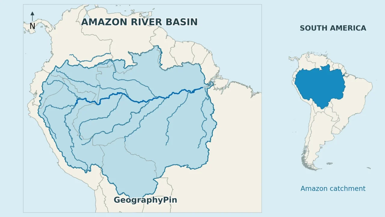
An Amazon map can show a river, a watershed, a rainforest region, or an administrative territory. Those outlines overlap, but they are not interchangeable. Reading them separately makes the countries, tributaries, and forest boundary much easier to understand.
The Amazon River basin is the land drained by the Amazon and its tributaries, extending from the Andes to the Atlantic. It overlaps much of the Amazon rainforest but is not identical to the biome or Brazil’s Legal Amazon. Country counts and area estimates change when those different boundaries are mixed.
How to use this article: Check the basin countries, follow the main river’s changing names, or compare the different Amazon boundaries.
1. Read the Basin Map Before the Country List
Follow water, not the green color
The Amazon River basin occupies much of northern South America, extending from Andean headwaters in the west toward the Atlantic coast of Brazil in the east. Its boundary is a drainage divide: on opposite sides of that divide, runoff generally enters different river systems. A river line shows one route through the landscape; the basin includes all the contributing land around its tributaries.

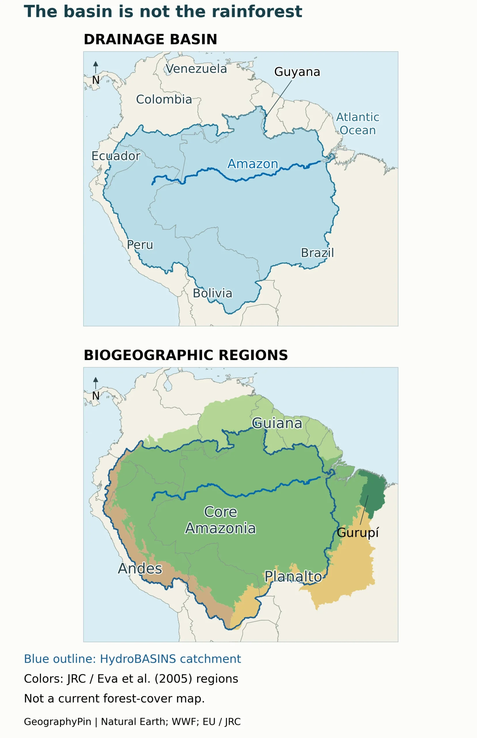
The comparison uses JRC’s 2005 geographical delimitation: core Amazonia plus Andes, Planalto, Guiana, and Gurupí. Its core region combines a northern basin limit, a western elevation criterion, and a southern pre-exploitation rainforest boundary. The other colors identify peripheral regions, not additional rainforest classes. This historical classification illustrates why ecological and drainage outlines differ; it does not measure forest remaining today.
Read the river network separately from the ecological shading. A place can contribute water to the Amazon without being tropical rainforest. Conversely, a forest can belong to the wider Amazon ecological region while its rivers reach the Atlantic through a different catchment. Country borders provide orientation, but do not define either natural boundary.
The western contrast is especially useful. The basin reaches into the Andes, including high terrain outside lowland rainforest. Farther northeast, forests of the Guiana Shield extend across drainage divides. In the south, the transition toward savanna also prevents the basin edge from being a simple forest edge.
These are regional reference maps, not navigation charts or parcel boundaries. Generalized river lines do not show every bend, island, side channel, or seasonal connection. Use the legend to identify which boundary is being shown before treating a shaded area as “the Amazon.”
2. Which Countries Share the Amazon Basin?
Seven countries under the drainage-basin convention
For the Amazon drainage system, this article uses the seven-country list reported by the Wildlife Conservation Society: Bolivia, Brazil, Colombia, Ecuador, Guyana, Peru, and Venezuela. Inclusion means that part of a country contributes to the system, not that the Amazon main channel flows through all seven.
| Country | Geographic connection |
|---|---|
| Bolivia | Southern catchments connected through the Madeira system. |
| Brazil | The main lower river, Atlantic outlet, and extensive tributary catchments. |
| Colombia | Northern and western tributaries, including the Caquetá/Japurá and Putumayo/Içá systems. |
| Ecuador | Andean and eastern headwaters feeding western Amazon tributaries. |
| Guyana | A small southern connection through the Takutu–Branco–Negro system, not the whole country. |
| Peru | Andean source regions and the Marañón–Ucayali river network. |
| Venezuela | Upper Negro drainage and the Casiquiare connection with the Orinoco. |
The modest northern connections matter: a basin-country list is not a ranking of how much land each country contributes. Nor is it permission to shade every included country as if all its rivers drain to the Amazon. For the political map behind these names, compare the countries of South America and their capitals.
Why other maps show eight countries and French Guiana
The WWF description of the Amazon biome covers eight sovereign countries and French Guiana: the seven above, plus Suriname and the French territory. This is an ecological region, not the same country list as the river basin. French Guiana is part of France, not a ninth sovereign country.
The Amazon Cooperation Treaty Organization, meanwhile, has eight member countries, including Suriname. An organization’s membership describes cooperation among governments; it does not establish the drainage divide. When a report says “eight Amazon countries,” check whether it means treaty members, rainforest geography, or a hydrological study area.
3. Trace the Main River and Its Major Tributaries
Marañón, Ucayali, Solimões, and Amazonas
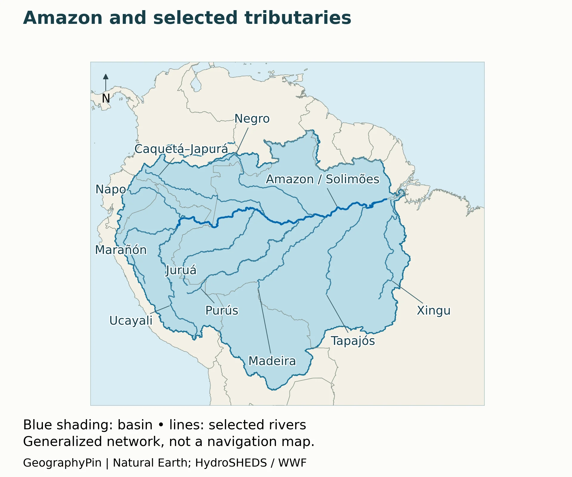
Follow the main river eastward from the meeting of the Marañón and Ucayali in Peru. These two rivers connect the upper system to many smaller Andean tributaries. The channel continues through the western lowlands and reaches Brazil; the Brazil–Colombia–Peru border area is a useful political reference, but the river network is much wider than that short frontier region.
Names change along the route. In Brazil, the upper Amazon is called the Solimões until its meeting with the Negro near Manaus; downstream, it is called the Amazonas. That naming change does not mean the watercourse begins at Manaus. The same connected system continues to the Atlantic.

| River or system | How to locate it |
|---|---|
| Marañón and Ucayali | Western headwater branches in Peru that unite to form the named Amazon. |
| Napo | A western tributary flowing from Ecuador into Peru. |
| Putumayo / Içá | A northern tributary with different names along its international course. |
| Caquetá / Japurá | Another northern tributary, connecting Colombia and Brazil. |
| Juruá and Purus | Long, winding southwestern tributaries entering the Solimões. |
| Negro | The northern system meeting the Solimões near Manaus; the Branco feeds it. |
| Madeira | A major southern system with catchments in Bolivia, Peru, and Brazil. |
| Tapajós | A southern tributary joining the Amazon near Santarém. |
| Xingu | A southern tributary joining farther downstream, toward the Atlantic. |
The table is a reading aid, not a complete inventory or a ranking by length. It also separates headwater branches from tributaries that join farther downstream. Follow each line to its junction rather than assuming that every river carrying an Amazon-region name meets the main channel directly.
Why the rivers look different at Manaus
NASA imagery of the Solimões–Negro confluence shows pale, sediment-laden Solimões water beside the darker Negro. The contrast reflects different sediment and organic-matter conditions in their catchments. Water color is therefore a clue to upstream landscapes, not a border between separate basins.
Manaus is a useful landmark for understanding this junction and the naming change. For its urban context rather than river-network geography, see the Manaus section in GeographyPin’s guide to major Brazilian cities.
4. The Basin, Rainforest, Biome, and Legal Amazon Are Different
Different questions, different map layers
| Term | What the boundary represents |
|---|---|
| Amazon River | The connected main channel, with local naming conventions. |
| Amazon drainage basin | Land contributing runoff to the Amazon and its tributaries under the chosen hydrological definition. |
| Amazon biome | A broad ecological region; its mapped extent depends on the classification used. |
| Present forest cover | Where a specified dataset detects forest at a specified date, not automatically the whole biome. |
| Brazil’s Legal Amazon | An administrative planning region defined by Brazilian legislation. |
A biome boundary is not a live outline of untouched forest. It can contain rivers, savannas, settlements, farms, and land where forest has been cleared. Conversely, a satellite forest-cover layer depends on the observation date and the definition of forest used by that product. Comparing the two without explaining their purpose can make land-cover change look like a change in the biome’s definition.
IBGE’s biome mapping groups regional vegetation and environmental characteristics. Its national Amazon biome layer stops at Brazil’s border because the product covers Brazil, not because the ecological region ends there. A Brazil-only dataset cannot be presented as the whole international rainforest boundary.
What Brazil’s Legal Amazon means
The Legal Amazon mapped by IBGE is a legislatively defined planning region. It encompasses the states of Acre, Amapá, Amazonas, Mato Grosso, Pará, Rondônia, Roraima, and Tocantins, plus the portion of Maranhão specified by the legal definition. It includes land outside the Amazon biome, so its area is not a measure of rainforest remaining.
This distinction changes how a statistic should be read. “Deforestation in the Legal Amazon” refers to a defined reporting territory and a particular monitoring method. It cannot automatically be substituted for forest loss across every Amazonian country. Likewise, a rainfall average for a river basin should not be relabeled an average for a political region.
5. Boundary Cases: Tocantins and the Casiquiare
Why the Tocantins sometimes appears with the Amazon
Brazil’s water agency, ANA, treats Tocantins–Araguaia as a separate hydrographic region. Its rivers reach the estuarine waters south of Marajó, close to the Amazon’s lower outlet complex. Proximity and interconnected coastal waters help explain why some regional studies group them together.
The UNEP GIWA Amazon Basin assessment, for example, explicitly included the Tocantins and additional coastal drainage in its study region. Its area figures therefore should not be compared directly with a dataset that excludes those catchments. Here, the Tocantins is not counted as an ordinary tributary joining the Amazon’s upstream main channel.
A natural link with the Orinoco
The Casiquiare in Venezuela connects the Orinoco and upper Negro systems. A study indexed by the U.S. Geological Survey examines its role as a corridor between the two basins. This is an important exception to the simple classroom picture of completely separate drainage trees.
The connection does not make the whole Orinoco basin part of the Amazon. It does mean that a coarse drainage model may simplify a real flow split. Near such connections, follow the source dataset’s method rather than treating a regional map line as a precise statement about every stream.
6. Where Does the Amazon Begin, and How Long Is It?
There are two different questions: where the river receives the name Amazon, and which upstream headwater is farthest from its ocean outlet. The Marañón–Ucayali confluence answers the first in Peru. Finding the farthest source requires following connected channels much farther into the Andes.
Research by James Contos and Nicholas Tripcevich, published in Area in 2014, compared the Apurímac and Mantaro routes using maps, satellite imagery, hydrographic data, and GPS observations. Their study placed the most distant source in the Mantaro drainage under its measurement approach, rather than the traditionally cited Nevado Mismi area in the Apurímac drainage.
A source chosen by longest upstream distance need not be the branch with the greatest flow or the name most familiar from older maps. National Geographic’s explanation of the source debate makes that distinction central. The measurement also depends on the channel followed and how its bends are resolved.
For that reason, this map does not proclaim a new longest-river winner or attach a falsely exact length to a generalized blue line. The Amazon’s enormous discharge and its ranking by length are different claims. To compare river lengths properly, use a stated source, outlet, measurement method, and date for both rivers; do not add together parallel tributaries that meet at a junction.
Frequently Asked Questions
Does the Amazon flow into the Pacific Ocean?
No. The Amazon reaches the Atlantic Ocean on Brazil’s northern coast. Many western headwaters begin in the Andes, but the water on the Amazon side of the divide travels toward the Atlantic, not across the mountains to the Pacific.
Does a location inside the basin flood every year?
No. A drainage basin includes uplands and slopes as well as river valleys. Seasonal inundation affects floodplains and other low-lying areas, not every place inside the watershed boundary. A basin map is not a flood-risk map.
Why can the river be low in one place while another tributary is rising?
The basin is large, and rainfall and river levels do not peak everywhere at once. Tributary timing and the travel of water downstream help explain different conditions across the network. A single gauge or photograph cannot describe the entire basin’s water level.
What Did We Learn Today?
The most useful Amazon map separates water flow from ecological and political boundaries. Trace tributaries to understand the basin, use a biome or dated land-cover layer to interpret forest geography, and treat the Legal Amazon as an administrative region. The Tocantins and Casiquiare show why the map’s definition matters as much as its outline; source and length claims require their own measurement rules.
Sources & Data Notes
The country list follows a drainage-system convention, not treaty membership or biome coverage. The GIWA report uses a broader region including Tocantins and is used for its explanation of that distinction, not as a current environmental-status assessment. No exact river-length ranking or current forest-area total is inferred from these maps.
Original cartography by GeographyPin uses Natural Earth country and river geometry (public domain), HydroBASINS v1c catchment geometry (WWF, licensed free use), and adapted JRC/Eva et al. (2005) region geometry (© European Union, CC BY 4.0; recolored and combined for this comparison). Lines are generalized and the regional river network is selective. Dataset edges may not align perfectly at country borders or drainage divides; small overlay slivers do not establish additional basin countries. The colored comparison is not a newly surveyed boundary, a WWF biome map, or a current forest inventory.
- JRC: Geographical Boundaries of Amazonia
- HydroBASINS: drainage-basin data and documentation
- Natural Earth: public-domain map data
- ANA: Amazon hydrographic region
- ANA: Tocantins–Araguaia hydrographic region
- UNEP: Amazon Basin, GIWA Regional Assessment 40b (2004); geographic definition and tributaries
- WWF: international Amazon biome
- IBGE: Legal Amazon
- Contos and Tripcevich (2014): Amazon source research
- NASA: Solimões–Negro confluence
- NASA: seasonal water flow in the Amazon
Map data attribution
This product GeographyPin Amazon maps incorporates data from the HydroSHEDS version 1 database which is © World Wildlife Fund, Inc. (2006–2022) and has been used herein under license. WWF has not evaluated the data as altered and incorporated within GeographyPin Amazon maps, and therefore gives no warranty regarding its accuracy, completeness, currency or suitability for any particular purpose. Portions of the HydroSHEDS v1 database incorporate data which are the intellectual property rights of © USGS (2006–2008), NASA (2000–2005), ESRI (1992–1998), CIAT (2004–2006), UNEP-WCMC (1993), WWF (2004), Commonwealth of Australia (2007), and Her Royal Majesty and the British Crown and are used under license. The HydroSHEDS v1 database and more information are available at https://www.hydrosheds.org.