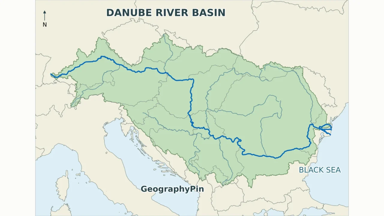
The Danube’s blue line and its drainage basin describe different geographies. One follows the river from southern Germany to the Black Sea; the other gathers tributaries and headwaters across a much wider part of Europe.
The Danube flows through or along ten countries between Germany and the Black Sea. Its wider drainage basin includes nineteen countries under the ICPDR’s reporting convention. Follow the main river to identify its riparian countries; use the basin and tributaries to understand how places well away from its banks are connected.
How to use this article: Follow the river route, compare the country-counting rule, or locate the three delta branches.
1. Read the Main River and Basin Together
Two different geographic questions
A river map follows a channel. A drainage-basin map includes the land whose surface waters feed that channel and its tributaries. For the Danube, the distinction changes the country count: the river itself reaches ten countries, while the International Commission for the Protection of the Danube River (ICPDR) lists nineteen in its wider basin.
Start with the Danube line and follow it toward the Black Sea. Then compare the surrounding catchment. An Alpine valley or a Carpathian headwater can belong to this system even when the Danube is far away. A national border and a drainage divide answer different questions; neither should be used as a substitute for the other.
The maps below are geographic references, not navigation charts or legal boundary surveys. River lines are generalized, so they do not resolve every island, side channel or local frontier. The physical map of Europe provides the wider mountain-and-lowland setting.


2. Follow the Danube from Germany to the Black Sea
Ordered river-route table
The sequence below follows the river downstream. It is not ten separate stretches laid end to end: two countries can face each other across the same reach. Croatia and Serbia are grouped because the route encounters their shared river-border region, not a clean crossing from one country into the next.
| Country or paired reach | Where to look | How to read the route |
|---|---|---|
| 1 · Germany | Donaueschingen and the upper river | The Breg and Brigach join at Donaueschingen; the named Danube continues across southern Germany. |
| 2 · Austria | Upper Danube, including Vienna | The river continues eastward through Austria toward Bratislava. |
| 3 · Slovakia | Bratislava and the Slovak–Hungarian reach | Slovakia has a direct relationship with the main river, not only tributaries. |
| 4 · Hungary | Danube Bend and Budapest | After the border reach with Slovakia, the Danube turns south through Hungary. |
| 5–6 · Croatia and Serbia | Middle Danube downstream of Hungary | Both countries meet the river along the Croatia–Serbia frontier region; farther downstream the river passes through Serbia and Belgrade. |
| 7 · Romania | Iron Gates and lower river | Romania meets the Danube along the Serbian frontier, then along the Bulgarian frontier, and through its eastern lowlands. |
| 8 · Bulgaria | Southern bank of the lower Danube | The river forms much of Bulgaria’s boundary with Romania. |
| 9 · Moldova | Giurgiulești, near the Prut confluence | A short river frontage is sufficient for inclusion; a long national reach is not required. |
| 10 · Ukraine | Lower Danube and northern delta | Ukraine meets the river downstream of Moldova and shares the delta region with Romania. |
The ICPDR’s Germany profile identifies the Brigach–Breg confluence as the beginning of the named Danube. References that measure from a headstream use a different starting point. A source marker at Donaueschingen therefore should not be mistaken for the most distant headwater in the entire river system.
A border river is not always a border line
“Flows through ten countries” is convenient shorthand, but “flows through or along ten countries” is more precise. Bulgaria is included even though the main river runs along its northern edge. Moldova also qualifies despite its very short frontage. These are not lesser connections: both meet the Danube itself.
The Croatia–Serbia reach needs particular care. Research on the Croatia–Serbia boundary dispute documents the competing interpretations. A small-scale river line cannot settle them or determine ownership of river islands. Here the countries are identified as riparian neighbors; the map is not offered as a cadastral boundary. Farther downstream, the Iron Gates identify the Serbia–Romania gorge reach, while the long Romania–Bulgaria reach helps orient the lower river.
3. Why the Basin Includes Nineteen Countries
The counting rule
Use the ICPDR’s published basin-country list, based on its 2021 basin-management-plan information. Count a country when some territory lies in that basin, not only when the Danube crosses it. This adds nine countries to the ten in the route table:
- Albania
- Bosnia and Herzegovina
- Czechia (Czech Republic)
- Italy
- Montenegro
- North Macedonia
- Poland
- Slovenia
- Switzerland
The resulting nineteen-country total is the ICPDR reporting convention. It is not a count of European Union members, Danube ports or countries crossed by the main channel. Its table includes a specific caveat about Serbia’s data excluding Kosovo and Metohija under its stated UN Security Council Resolution 1244 convention. The total should therefore be attributed rather than presented as a fresh, universal settlement of political recognition.
How a country can belong without touching the Danube
Slovenia illustrates the difference. Its Sava waters travel onward through the wider river network before reaching the Danube at Belgrade. Bosnia and Herzegovina also connects through the Sava system. Neither needs a bank on the main Danube to be part of the basin.
Italy offers a less obvious example: the ICPDR identifies headwaters feeding the Drava and the Spöl–Inn system as connections to the Danube drainage. Coloring the whole Italian peninsula as Danube drainage would plainly misrepresent that small geographic contribution. The same caution applies to any country only partly inside a catchment.
A basin’s membership also differs from membership of its management organization. The ICPDR lists fourteen country contracting parties, plus the European Union; five additional basin countries cooperate without being full contracting parties. River geography, institutional membership and political geography are related, but they are not interchangeable lists.
4. Major Tributaries: Follow the Connections
Tributaries join the Danube; they do not replace it on the country list. Several have different names in neighboring languages. The following selection is ordered broadly downstream by confluence, not ranked by size. It is not a complete inventory of the river’s tributaries.
| Tributary | Danube connection | Why it matters |
|---|---|---|
| Inn | Passau | Connects Alpine drainage to the upper Danube; the river name does not automatically follow the branch carrying more water. |
| Morava / March | Near Bratislava | Brings water from a basin shared by Czechia, Slovakia and Austria. |
| Drava / Drau | Downstream of Osijek | Connects Alpine headwaters and southeastern European lowlands to the middle river. |
| Tisza / Tisa / Tysa | Serbia, upstream of Belgrade | Drains a major Carpathian–Pannonian sub-basin shared by five countries. |
| Sava | Belgrade | Brings water from the western Balkans and neighboring Alpine areas; ICPDR identifies it as the largest tributary by discharge. |
| Siret | Near Galați | Connects territory east of the Carpathians with the lower Danube. |
| Prut | Near Giurgiulești | Meets the lower Danube near Moldova’s southern tip after following the Romania–Moldova frontier. |
“Largest tributary” requires a metric. Water discharge, river length and drainage area measure different things. The ICPDR’s Sava profile calls the Sava the largest by discharge and second largest by catchment area. Calling every prominent tributary simply “the largest” would hide that distinction.
The Tisza basin is shared by Ukraine, Romania, Hungary, Slovakia and Serbia. That five-country catchment is not a new group to add on top of the Danube’s nineteen: it is nested inside the larger basin. In the same way, a tributary of the Sava ultimately contributes to the Danube without needing to join the main river directly.
The northern Morava/March should not be confused with Serbia’s Velika Morava system farther downstream. Repeated river names are one reason a confluence location is more useful than a name alone.
5. The Delta: Three Main Branches, Not One Mouth
Chilia, Sulina and Sfântu Gheorghe
Near the Black Sea, the Danube divides into distributaries: branches carrying water away from the main channel. This reverses the pattern of tributaries, which carry water into it. The three principal delta branches are Chilia (also called Kiliya), Sulina and Sfântu Gheorghe (St George).
Chilia/Kiliya is the northern branch associated with the Romania–Ukraine boundary. Sulina lies between it and the southern Sfântu Gheorghe branch. Most of the delta is in Romania, with a northern portion in Ukraine. A single dot marked “mouth” is consequently only an orientation aid, not a complete representation of all the outlets.
The delta contains smaller channels, lakes, wetlands and changing coastal landforms. A basin-scale map cannot display them all. The names of the three branches help readers understand the layout without implying that every distributary follows a simple, permanent line or carries an equal share of the flow.
The receiving water is the Black Sea. It is not necessary to follow the river through the Bosporus to define its mouth: the river–sea transition occurs at the delta’s Black Sea outlets.
6. What the River Map Does Not Tell You
A channel line does not tell you whether a particular boat can pass. Depths, locks, water levels and operating restrictions require dedicated navigation information. Likewise, a basin boundary is not a map of flooding: land inside the catchment is not all floodplain, and not all of it floods during the same event.
River access also does not turn an inland state into a coastal country. Austria, Slovakia, Hungary, Serbia and Moldova remain landlocked countries despite their Danube connections. The geographic test is a sea coastline, not the existence of a downstream water route.
Finally, do not infer precise lengths or areas by measuring an overview image. River bends are generalized, tiny catchment fragments may be hard to see, and source and outlet choices affect length measurements. For the question “which countries?”, the stated counting method and the route table are more dependable than counting only the labels visible on a reduced map.
Frequently Asked Questions
Are Donau, Duna and Dunărea different rivers?
These are names for the Danube in different languages: German, Hungarian and Romanian respectively. A change of name on a map is not a new tributary or an interruption in the river.
Which national capitals stand on the Danube itself?
Vienna, Bratislava, Budapest and Belgrade are the four identified by the ICPDR. Other capitals connect through tributaries, which is a different relationship from sitting on the main river.
What Did We Learn Today?
A useful Danube map separates the river’s route from the land draining into it. Border reaches explain the ten main-river countries, while tributaries explain the broader nineteen-country basin convention. At the Black Sea, tributaries give way to distributaries: the delta divides the flow among several outlets rather than ending at one simple point.
Sources & Data Notes
Country totals follow the ICPDR’s distinction between the main river and its basin, with the wider list taken from its 2021 plan-based table. Countries sharing a river-border reach are not separate sequential lengths. No population, exact basin-area total or navigation clearance is inferred from the maps. The maps are generalized references and do not determine disputed boundaries.
- ICPDR: Danube River Basin Overview Map
- ICPDR: Countries of the Danube River Basin; 2021 plan-based country table
- ICPDR: Germany and the named river’s source
- ICPDR: Hungary and its Danube border reach
- ICPDR: Moldova and its short Danube frontage
- ICPDR: Italy’s connections to Danube drainage
- ICPDR: Sava Basin
- ICPDR: Tisza Basin
- ICPDR: Danube Delta
- ICPDR: River Basin and selected tributaries
Original GeographyPin cartography combines public-domain Natural Earth 1:10 million borders and river centerlines with HydroBASINS Europe level 3 version 1c catchment geometry. The north-up maps use a regional latitude–longitude display with aspect correction; the two route panels have different extents. The modeled catchment is not used to recalculate the ICPDR country total.
- Natural Earth data and public-domain terms
- HydroBASINS data and method
- HydroSHEDS technical documentation and license
- ICPDR contracting parties
- ICPDR: Delta–Liman flood action plan
- Meandering Limits: the Danube border dispute between Croatia and Serbia
- Collins Dictionary: Danube and language variants
This product GeographyPin Danube maps incorporates data from the HydroSHEDS version 1 database which is © World Wildlife Fund, Inc. (2006–2022) and has been used herein under license. WWF has not evaluated the data as altered and incorporated within GeographyPin Danube maps, and therefore gives no warranty regarding its accuracy, completeness, currency or suitability for any particular purpose. Portions of the HydroSHEDS v1 database incorporate data which are the intellectual property rights of © USGS (2006–2008), NASA (2000–2005), ESRI (1992–1998), CIAT (2004–2006), UNEP-WCMC (1993), WWF (2004), Commonwealth of Australia (2007), and Her Royal Majesty and the British Crown and are used under license. The HydroSHEDS v1 database and more information are available at https://www.hydrosheds.org.