A map that stops at Maine leaves out a substantial part of the Appalachians. A map of “Appalachia” may show a completely different boundary. The key is to separate the physical mountain system from a cultural region, an economic-development area and a famous hiking trail.
The Appalachian Mountains extend through eastern North America from Alabama to Newfoundland, including a substantial Canadian continuation. They are a system of ranges, valleys and uplands, not one continuous ridge. The Appalachian Trail ends in Maine, while the policy region called Appalachia uses a different, county-based boundary.
How to use this article: Start with the map, check the Canadian continuation, or compare the mountains, region and trail.
1. Appalachian Mountains map: follow the whole system
Read the mountain system, not a single ridge
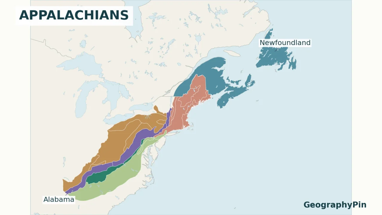
The Appalachians form a long belt through eastern North America, running northeast from Alabama through the eastern United States and into Canada. The Canadian continuation reaches Newfoundland. That is the scope used here: the mountain system and associated uplands, not just the Appalachian Trail or the U.S. economic-development region called Appalachia.
- Appalachian Plateaus
- Valley and Ridge
- Blue Ridge
- Piedmont
- New England
- Canadian Appalachian Uplands

Map convention: U.S. colors show the Appalachian Plateaus, Valley and Ridge, Blue Ridge, Piedmont and New England provinces. The Canadian color represents the broader Appalachian Uplands region, including Prince Edward Island and other lower-relief areas. These national classifications are not identical. The map does not shade the Adirondacks or St. Lawrence Valley, even though the historical U.S. framework groups them within the larger Appalachian Highlands division.
Map sources and boundary method
U.S. polygons use the USGS physiographic divisions dataset, digitized from Fenneman’s regional mapping, retrieved through a D.C. government hosted copy. Canada uses Natural Resources Canada’s physiographic regions. Natural Earth public-domain data supply base geography. No range boundary was hand-drawn. The Lambert conformal conic projection preserves regional shape well; the scale bars are approximate regional distances, not mountain-system lengths. Small-scale boundaries are unsuitable for local navigation. Canadian information is used under the Open Government Licence – Canada; no endorsement is implied.
Look first at the overall southwest–northeast alignment, then at the different regions within it. The mountains are not one uninterrupted crest. They include parallel ridges, intervening valleys, uplands and deeply dissected plateaus. Water separates some Canadian parts of the system, so a map of its geological and physiographic extent does not represent a continuous walking route.
A physiographic region groups terrain by its landforms and geological setting. Its boundary need not mark an abrupt wall of mountains. This matters especially along the lower-relief margins: belonging to the broader Appalachian framework does not mean that every location has a high summit.
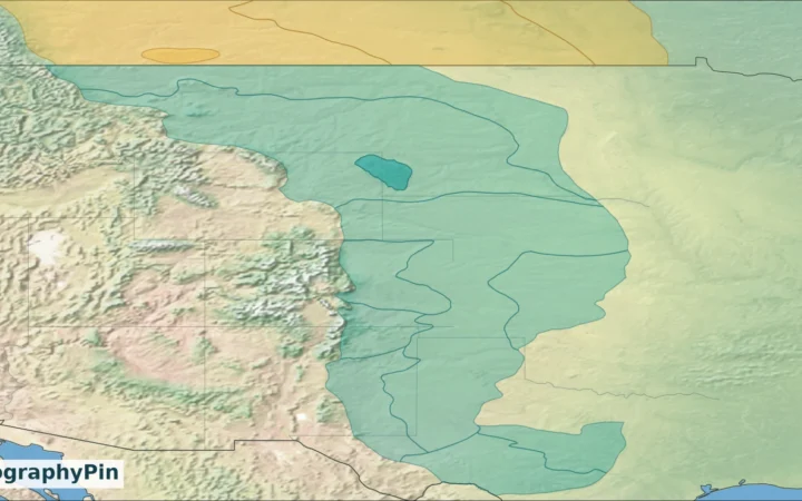
For the larger continental setting, the physical map of the USA places the Appalachians east of the interior plains and far from the western mountain systems. This closer view explains the eastern system rather than treating it as one label on a national map.
2. Where do the Appalachian Mountains start and end?
The southern end: Alabama, not Springer Mountain
Alabama is the usual southern endpoint for the Appalachian mountain system. The National Park Service’s explanation of collisional ranges extends the Appalachians into northern Georgia and Alabama. Different component provinces taper out in different places; there is no single southern summit that acts like a trailhead for the entire system.
In the Valley and Ridge province, the folded landscape continues southwest before disappearing beneath younger Coastal Plain deposits. The mountain-building structures themselves extend farther than the exposed mountain landscape. That geological continuation is not a reason to draw one unbroken surface mountain range across the Gulf Coastal Plain.
The northern end: include Canada and Newfoundland
Maine is not the end of the mountain system. Appalachian terrain continues into southeastern Canada, including southern Quebec and Atlantic Canada. Parks Canada describes the Cape Breton Highlands as part of the Appalachian chain, while its Terra Nova management plan explicitly places that eastern Newfoundland landscape within the Appalachian Mountain System.
Newfoundland is an island within the province of Newfoundland and Labrador. Saying that the system reaches Newfoundland does not mean that all of Labrador belongs to the Appalachians. Likewise, the Canadian Appalachian physiographic region includes lower-relief terrain as well as named mountain ranges: it should not be read as a map of land above a particular elevation.
The endpoint answer therefore depends on the object being mapped. For the full North American system, use Alabama to Newfoundland. For the famous U.S. footpath, use Georgia to Maine. Mixing those two extents produces a map that seems plausible but answers the wrong question.
3. Major subdivisions and the landscapes they describe
There are two useful ways to divide the Appalachians. Broad labels such as northern, central and southern Appalachians locate a part of the long belt. Physiographic provinces describe landforms and geological structure. The two approaches are not interchangeable, and their boundaries should not be combined into one supposedly universal classification.
| Component | Where to look | What distinguishes it |
|---|---|---|
| Appalachian Plateaus | Western side of the U.S. system, from New York toward Alabama | Layered sedimentary rocks cut into rugged terrain by streams |
| Valley and Ridge | Long southwest–northeast belt through the central and southern Appalachians | Alternating ridges and valleys developed in folded rock |
| Blue Ridge | Pennsylvania southwest to Georgia | Mountainous terrain that includes the Great Smoky and Black Mountains |
| Piedmont | East of the principal mountain belts | Related rolling upland, not a continuous high mountain crest |
| New England province | Northeastern United States | Includes the Taconic, Green and White Mountains |
| Canadian Appalachian Uplands | Southeastern Quebec and Atlantic Canada, continuing to Newfoundland | A broad physiographic region with varied uplands and lower-relief areas |
Why a plateau can look like mountains
A plateau does not have to look flat from a valley floor. The NPS Appalachian Plateaus description explains that streams cut through largely horizontal rock layers, leaving steep slopes and high remnants between valleys. The Catskill, Pocono, Allegheny and Cumberland Mountains occur within this province.
Valley and Ridge terrain has a different underlying pattern. There, folded sedimentary layers expose rocks with different resistance to erosion. More resistant layers commonly form ridges, while weaker rocks are worn into valleys. The long, repeated bands seen on a relief map reflect that structure rather than a collection of unrelated hills.
Blue Ridge, Smokies and Mount Mitchell
The Blue Ridge is a subdivision, not a synonym for all the Appalachians. The NPS Blue Ridge account includes the Great Smoky Mountains along the Tennessee–North Carolina border and the Black Mountains within the province. Mount Mitchell, in North Carolina’s Black Mountains, rises to 6,684 feet (2,037 meters). North Carolina State Parks identifies it as the highest point east of the Mississippi River.
Farther north, the Green Mountains in Vermont and White Mountains in New Hampshire are familiar names within the New England province. Local range names help readers orient themselves, but they are not all regions of equal size or the same classification level. A province can contain several named ranges.
4. Mountains, Appalachia and the Appalachian Trail compared
Different boundaries answer different questions
| Name | What it represents | Extent or boundary rule |
|---|---|---|
| Appalachian Mountains | Mountain system and associated landforms | Eastern North America, Alabama to Newfoundland; physical geography |
| ARC Appalachian Region | U.S. economic-development policy region | Selected counties in 13 states, from southern New York to northern Mississippi |
| Appalachian National Scenic Trail | A managed hiking route | Springer Mountain, Georgia, to Katahdin, Maine, through 14 states |
| Cultural Appalachia | A region of identity, history and cultural connections | No single universally accepted boundary; not automatically identical to ARC’s footprint |
The Appalachian Regional Commission defines a policy region of 423 counties across 13 states. Its footprint includes all of West Virginia and parts of twelve other states. It is appropriate for interpreting ARC programs and regional statistics, but it leaves out New England and Canada even though both belong in an explanation of the mountain system.
The NPS Appalachian Trail geodiversity atlas identifies Springer Mountain and Katahdin as the trail’s endpoints. Those endpoints do not define where Appalachian geology starts or stops. A state crossed by the trail is also not interchangeable with a state covered by ARC’s county-based region.
For the same reason, a map of the four U.S. Census regions serves another purpose again. State-based statistical regions cannot substitute for a mountain-system map, a county-based policy boundary or a hiking route. A place can belong to several differently defined regions at the same time without any of those labels being contradictory.
5. Why the mountains have ridges, gaps and rounded uplands
The Appalachians record multiple episodes of mountain building, not one sudden event. Continental collisions compressed and deformed rocks; later erosion, renewed uplift in parts of the region and glaciation in the north helped shape the terrain visible today. The age of a rock is not automatically the age of the slope or valley cut into it.
That distinction prevents a common oversimplification: “old mountains” does not mean a landscape that has remained unchanged since it formed. The mountain-building history helps explain the broad arrangement of rock belts, while younger surface processes explain many present-day landforms.
In the Valley and Ridge province, rivers sometimes cross resistant ridges through narrow water gaps. The Delaware Water Gap is a useful example of why the whole system should not be drawn as an impassable wall. Elsewhere, plateau streams carve valleys into rock layers rather than simply following a single continuous summit line.
The New England province also preserves the effects of glacial erosion and deposition. Canadian landscapes such as Cape Breton combine a mountain-building inheritance with erosion and glaciation. These differences are part of the Appalachian system, not exceptions that must be removed from its map. The broader explanation of landforms created by erosion helps distinguish the processes that shape these valleys and uplands.
6. How to avoid misreading an Appalachian map
Check the map’s subject before counting states. A trail map, an ARC county map and a physiographic map use different boundaries. There is no useful universal “Appalachian states” total unless the author first says which definition is being counted.
Do not treat a shaded region as uniformly mountainous. A broad physiographic classification can include rolling uplands and intervening low areas. A small-scale map also smooths local complexity: its outlines are not property boundaries or precise hiking guidance.
Do not extend the Blue Ridge label over the entire chain. The Blue Ridge is only one component. Plateau landscapes to the west, the New England ranges and the Canadian continuation are essential to understanding the larger system.
Keep the terrain boundary separate from the international border. The Appalachians do not stop where the United States ends. Conversely, including Canadian Appalachian terrain does not turn the whole of eastern Canada into one mountain range. Read the named regions together with the map’s stated classification.
Frequently Asked Questions
Are the Adirondacks part of the Appalachians?
Their classification needs care. Older broad physiographic groupings sometimes place the Adirondacks with the Appalachian Highlands, but their geology is closely related to the Canadian Shield. An NPS study of the Adirondacks describes their geological relationship with Canada’s Laurentian Highlands. They should not be silently treated as another part of the same Appalachian mountain-building belt. They are not shaded on this map.
Does a map of Appalachian geology show the best hiking route?
No. It explains the regional landscape, not trail access, difficulty, closures or navigation. Use the relevant land manager’s trail map for a walk; a small-scale mountain-system map cannot supply those details.
What Did We Learn Today?
An Appalachian map makes sense only when its scope is explicit. The physical system continues from Alabama into Canada and Newfoundland, and its component landscapes include plateaus and valleys as well as mountain ranges. The Appalachian Trail and ARC’s Appalachian Region describe different things. Reading those definitions first prevents endpoint mistakes, misleading state counts and the assumption that every shaded area is a high ridge.
Sources & Data Notes
The article distinguishes a mountain system from a policy region and a hiking route. Physiographic classifications organize landforms; they are not elevation thresholds or a universally fixed outline of every mountain. Mount Mitchell’s metric elevation is rounded from 6,684 feet. ARC’s 423-county figure describes its policy footprint, not the mountain system. Map sources and boundary conventions are given with the figure.
- National Park Service: Collisional Mountain Ranges
- NPS: Appalachian Plateaus Province
- NPS: Valley and Ridge Province
- NPS: Blue Ridge Province
- NPS: New England Province
- NPS: Piedmont Province
- Parks Canada: Cape Breton Highlands geology
- Parks Canada: Terra Nova management plan, 2019
- Appalachian Regional Commission: About the Appalachian Region
- NPS: Appalachian Trail Geodiversity Atlas
- North Carolina State Parks: Mount Mitchell
- NPS: Adirondack Camps context study, geological setting