East Asia is a geographic region, not a single political organization. A useful map must show where its places lie while distinguishing countries, special administrative regions and Taiwan rather than treating every numbered location as the same kind of entity.
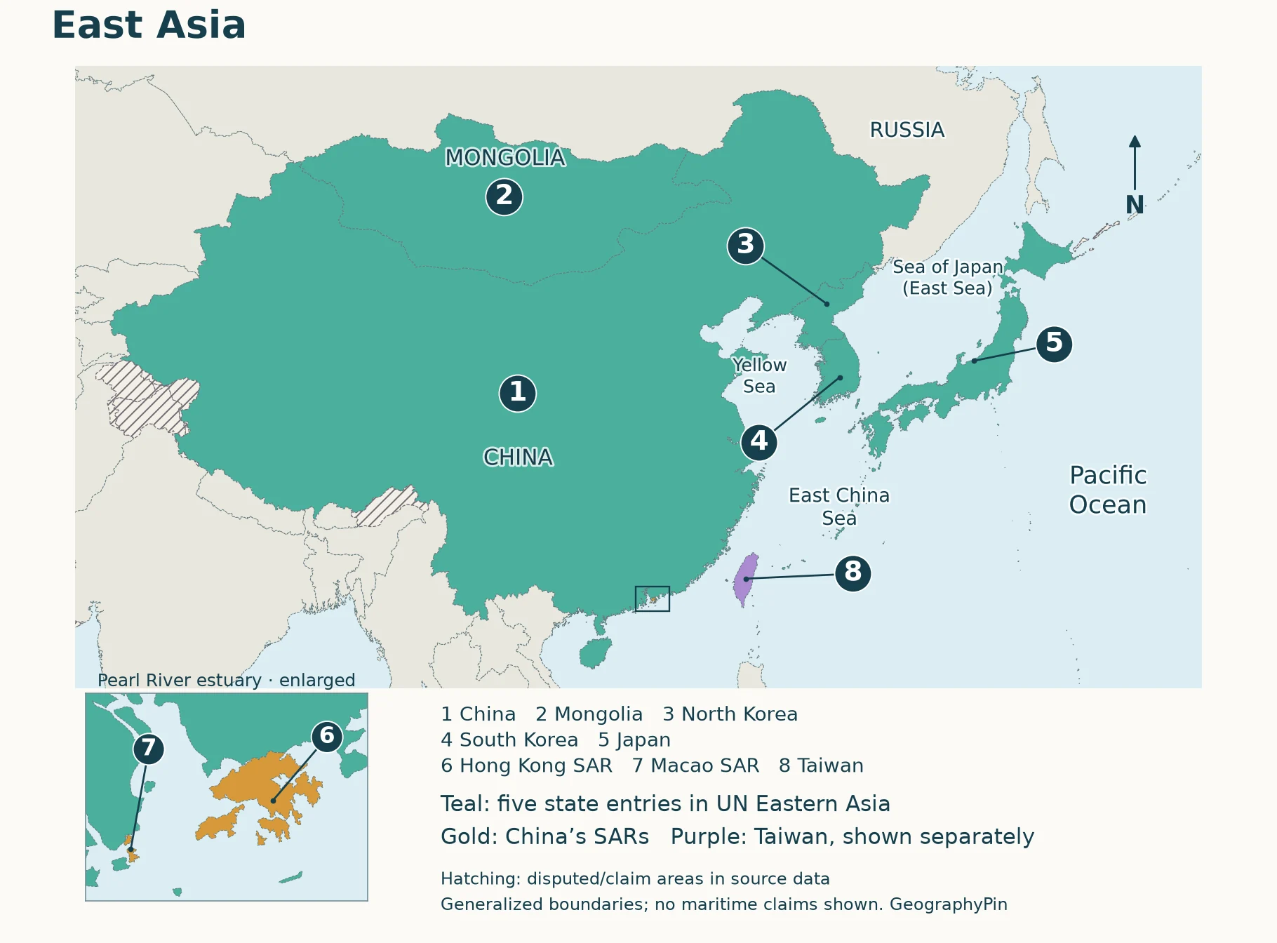
The UN M49 Eastern Asia grouping contains China, Japan, Mongolia, North Korea and South Korea, plus Hong Kong and Macao as separate statistical areas. This map follows that regional reference and also locates Taiwan separately, with an explicit status note. Its eight numbered locations are not a claim that East Asia contains eight sovereign countries.
How to use this article: Match the map numbers, understand Taiwan’s separate treatment, or locate the surrounding seas.
1. Read the East Asia Map
Start with the continental mainland, then move east to the Korean Peninsula and Japan. Mongolia lies inland north of China. Taiwan lies off China’s southeastern coast, while Hong Kong and Macao occupy much smaller coastal locations farther southwest.

What the eight map numbers mean
| No. and place | Classification used here | Where to look |
|---|---|---|
| 1. China | UN member state; Eastern Asia entry | Large mainland area, south of Mongolia |
| 2. Mongolia | UN member state; Eastern Asia entry | Landlocked between China and Russia |
| 3. North Korea | Democratic People’s Republic of Korea; UN member state | Northern Korean Peninsula |
| 4. South Korea | Republic of Korea; UN member state | Southern Korean Peninsula |
| 5. Japan | UN member state; Eastern Asia entry | Island arc east of the Korean Peninsula |
| 6. Hong Kong | Special administrative region of China; separate M49 area | East side of the Pearl River estuary |
| 7. Macao | Special administrative region of China; separate M49 area | West side of the Pearl River estuary |
| 8. Taiwan | Self-governed; claimed by the PRC; separate map locator | Across the Taiwan Strait from mainland China |
The numbers are simply a reading key. They do not rank the places by population, area or importance, and a numbered symbol does not assign sovereignty. Small coastal locations need markers or an inset because their real outlines would be hard to distinguish at the scale needed to show China and Mongolia.
2. Countries, Areas and the Counting Convention
Why a country total needs a definition
The United Nations Statistics Division’s M49 standard calls this subregion “Eastern Asia.” Its seven listed countries or areas consist of five UN member-state entries and two Chinese special administrative regions. Separate statistical entries should not be added together and relabeled as seven independent countries.
M49 is useful because its scope is explicit and reproducible. It is not an alliance, a cultural boundary or a ruling on every political dispute. The UN says the grouping is for statistical convenience and does not imply political affiliation. A geographic study can use a different regional scope, but it should name that scope rather than change its list silently.
Hong Kong and Macao are not additional countries
Hong Kong and Macao are special administrative regions, often abbreviated SARs, of the People’s Republic of China. Their separate statistical treatment explains why they appear alongside China in the M49 table. The Hong Kong Basic Law and Macao’s constitutional documents establish their legal frameworks. Neither SAR is counted here as an additional sovereign state.
On the map, Hong Kong is east of the Pearl River estuary and Macao is west of it. They are two different coastal places, not alternate names for the same city. “Macau” is another common English spelling; “Macao” follows the UN entry used in this reference.
Why Taiwan has a separate locator
Taiwan is self-governed under the Republic of China authorities; the People’s Republic of China claims sovereignty over it. The Congressional Research Service’s Taiwan overview distinguishes that claim from control. Those are different facts and should not be collapsed into a single unqualified map color.
UN M49 does not list Taiwan separately in its main country-or-area table. Its explanatory note treats Taiwan within China for that statistical framework, while allowing code 158 for strictly statistical purposes. This article identifies that convention without presenting it as a description of who governs Taiwan on the ground.
The separate Taiwan locator answers a geographic question: where is the island relative to mainland China, Japan and the Philippines? It is not an assertion that all governments recognize Taiwan as a sovereign state. For the broader regional count and capital list, use the Asia countries-and-capitals reference.
3. Mainland, Peninsula and Island Geography
Three shapes that make the region easier to recognize
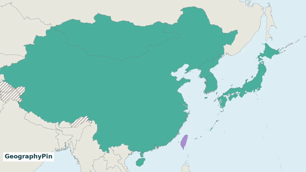
The mainland: China occupies the largest mainland footprint in this map, extending far west of its Pacific-facing coast. Mongolia is a separate landlocked country between China and Russia. A regional name containing “East” does not mean that every included location is coastal.
The peninsula: North Korea and South Korea occupy the Korean Peninsula, projecting from the Asian mainland. China is to its northwest, with a short Russia–North Korea border at the northeastern end. The peninsula is a physical feature; it should not be mistaken for a single present-day state.
The island arc: Japan lies east of the peninsula and mainland. Its four large islands are Hokkaido, Honshu, Shikoku and Kyushu, with additional islands extending beyond them. Taiwan sits farther southwest, separated from the mainland by the Taiwan Strait. A line of islands on a small-scale map is not necessarily one country or one administrative unit.
Use the seas to keep your bearings
- Yellow Sea: between eastern China and the Korean Peninsula.
- Sea of Japan / East Sea: between Japan and the Korean Peninsula, extending north toward Russia. These names refer to the same body of water; Korean and Japanese official sources use different names.
- East China Sea: between China’s east coast and the islands toward Japan, north of Taiwan.
- Taiwan Strait: between Taiwan and mainland China.
- Pacific Ocean: east of Japan and Taiwan.
Sea labels describe bodies of water, not ownership of the water. This is a locator map rather than a chart of territorial seas, exclusive economic zones or navigation routes. The Southeast Asia map continues the regional picture to the south, including the Philippines and mainland Southeast Asia.
4. What the Map Does Not Decide
A broad regional map has to simplify. Natural Earth outlines give a consistent small-scale base, but they are not a legal boundary survey. Disputed features and tiny offshore islands cannot all be resolved at a scale that also shows the full mainland region.
Keep three questions separate when reading any East Asia map: Where is the place? is a locator question. Which regional list includes it? is a classification question. Who governs or claims it? is a political-status question. A single color cannot reliably answer all three.
Russia appears north of the region as geographic context, not as an extra member of this M49 group. The same framework assigns the Russian Federation to Eastern Europe as a whole even though much of its land lies in Asia. Nearby Vietnam and the Philippines belong to M49 South-eastern Asia, not Eastern Asia.
Regional labels also depend on the subject. “East Asia” may be used in physical, cultural, historical or economic studies with a different emphasis. Treat this map as a named regional reference, not as a claim that language, culture, climate and political borders share one universal edge. Once the locations are familiar, the Asia geography quiz provides a different way to practice the broader continent.
Frequently Asked Questions
Are East Asia and Asia-Pacific interchangeable?
No. East Asia is a subregion of Asia. “Asia-Pacific” is a broader label used for areas around the Pacific and has no single roster that can be substituted for the M49 Eastern Asia list. Check the definition used by the specific organization or study.
What Did We Learn Today?
East Asia becomes easier to read when location and status are kept separate. The mainland, Korean Peninsula and Japanese island arc provide the geographic framework; the numbered key explains which places are states, which are Chinese special administrative regions and why Taiwan has its own locator. Naming the regional convention prevents an eight-location map from becoming a misleading eight-country claim.
Sources & Data Notes
The reference list follows UN M49 Eastern Asia. Taiwan is added as a geographic locator, not as an additional M49 entry or a recognition judgment. Natural Earth supplies generalized public-domain geographic data; GeographyPin created the numbered cartography. Small-scale boundaries and marker symbols are for orientation, not legal delimitation or navigation. Political-status discussion separates administrative control from claims and uses the cited official documents and CRS overview.
- UN Statistics Division: M49 regional groups and Taiwan statistical note
- Hong Kong Basic Law: General Principles
- Macao SAR Government: Constitutional Documents
- Congressional Research Service: Taiwan: Defense and Military Issues, July 25, 2025
- Web Japan: Geography and Climate
- Ministry of Foreign Affairs of Japan: Sea of Japan / East Sea naming discussion
- Taroko National Park: Where is Taiwan?
- Embassy of Mongolia: About Mongolia
- Macao Meteorological and Geophysical Bureau: geographic setting
- Natural Earth: public-domain map data and terms of use