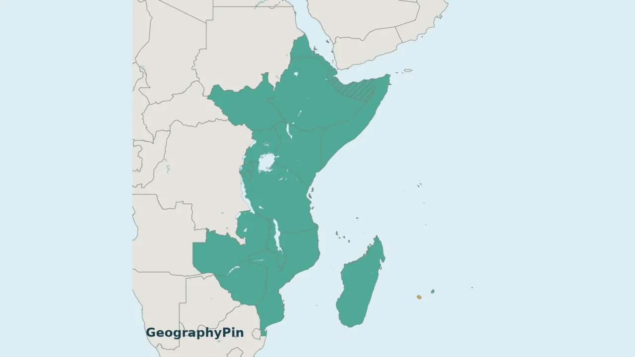
An East Africa countries map can look surprisingly different depending on who made it. A statistical region, a geographic peninsula and a regional organization answer different questions. Start with the map’s definition before comparing its country count with another list.
Using UN M49 Eastern Africa, this map includes 18 sovereign states and distinguishes four additional statistical areas. The Horn of Africa is a smaller geographic grouping, while the East African Community has its own membership. Mainland and island panels keep small places visible without treating every mapped area as an independent country.
How to use this article: Match the country numbers, identify the islands and area entries, or compare EAC membership with the regional map.
1. Read the East Africa Map
The mainland panel runs from Eritrea and the Horn in the north to Mozambique and Zimbabwe in the south. The separate island panels cover the Indian Ocean locations. Numbers identify states; letters identify the other areas listed by the UN. They are lookup labels, not a ranking.
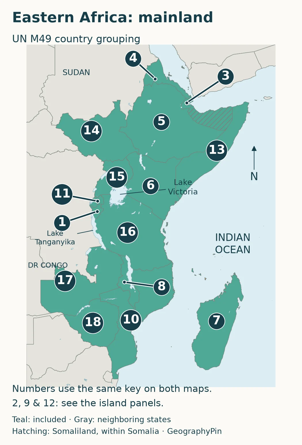
Both maps share one country key. Comoros (2), Mauritius (9) and Seychelles (12) appear in the island panels; Madagascar (7) appears in both. Follow each callout line to its endpoint, not the position of its number badge.
Country number key
| Country | Map location | EAC member | Narrow Horn |
|---|---|---|---|
| 1. Burundi | Mainland; south of Rwanda | Yes | No |
| 2. Comoros | Island panel; northwest of Madagascar | No | No |
| 3. Djibouti | Mainland; beside the Gulf of Aden | No | Yes |
| 4. Eritrea | Mainland; along the Red Sea | No | Yes |
| 5. Ethiopia | Mainland; inland in the Horn | No | Yes |
| 6. Kenya | Mainland; north of Tanzania | Yes | No |
| 7. Madagascar | Island panel; east of Mozambique | No | No |
| 8. Malawi | Mainland; between Zambia, Tanzania and Mozambique | No | No |
| 9. Mauritius | Island panel; east of Madagascar | No | No |
| 10. Mozambique | Mainland; opposite Madagascar | No | No |
| 11. Rwanda | Mainland; north of Burundi | Yes | No |
| 12. Seychelles | Island panel; northeast of Madagascar | No | No |
| 13. Somalia | Mainland; eastern tip of the Horn | Yes | Yes |
| 14. South Sudan | Mainland; south of Sudan | Yes | No |
| 15. Uganda | Mainland; west of Kenya | Yes | No |
| 16. Tanzania | Mainland; south of Kenya | Yes | No |
| 17. Zambia | Mainland; west of Malawi | No | No |
| 18. Zimbabwe | Mainland; south of Zambia | No | No |
The EAC and narrow-Horn columns compare the conventions explained below. The EAC also includes the Democratic Republic of the Congo, which is absent from this table because M49 places it in Middle Africa. Membership follows the EAC roster consulted in November 2026. The table uses common short names; the UN entry for Tanzania is “United Republic of Tanzania.” Small mainland countries use leader lines so their numbers do not obscure neighboring boundaries. For a continent-wide view rather than this regional comparison, open the Africa map and regional sheets.
2. Which Countries and Areas Are Included?
The UN Statistics Division’s M49 list groups countries and areas for statistical use. It is not a list of EAC members or a ruling that geography, culture and political identity share the same boundary. This article’s 18-country count excludes the four additional area entries below.
Islands and the four additional area entries
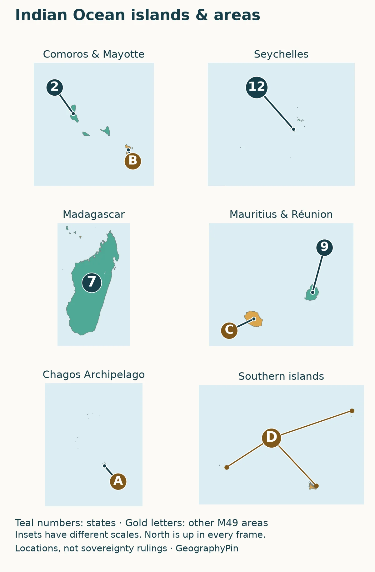
Comoros, Madagascar, Mauritius and Seychelles are the four sovereign island states in this grouping. Their ocean location does not remove them from the statistical region. The island map uses several frames because squeezing both mainland Africa and distant island groups into one phone-width image would make the smaller places disappear.
| Map letter and M49 entry | How it is treated here |
|---|---|
| A. British Indian Ocean Territory | Chagos locator; the M49 name is retained as a statistical label, not a declaration about treaty implementation. |
| B. Mayotte | Separate M49 area; administered by France and claimed by Comoros. |
| C. Réunion | Separate M49 area; a French overseas department, not another independent country. |
| D. French Southern Territories | One M49 area entry covering widely separated islands; selected southern groups are shown, not every island. |
The UK Parliament’s Chagos treaty briefing explains the 2025 UK–Mauritius agreement. A statistical name is not evidence that the agreement has or has not entered into force. This locator deliberately does not claim to resolve that changing legal question.
Mayotte illustrates a different distinction: administration and a sovereignty claim can coexist. France describes its departmental status; the UN’s Mayotte agenda item records the continuing international question. The gold locator distinguishes the area entry without presenting its color as a sovereignty judgment.
“French Southern Territories” is the M49 label used here. The TAAF administration also has an Antarctic district, but Antarctica is a separate M49 region. The southern-island inset does not turn an Antarctic claim into part of East Africa, and it does not show every Scattered Island in the Mozambique Channel.
3. Eastern Africa, the Horn and the EAC Compared
| Label | What determines the list |
|---|---|
| UN Eastern Africa | Statistical grouping: 18 sovereign states plus four separately listed areas. |
| Horn of Africa, narrow convention | Djibouti, Eritrea, Ethiopia and Somalia; broader political definitions can add neighbors. |
| East African Community | Membership in an intergovernmental organization, not a physical-geography boundary. |
The Horn is smaller than the UN region
The Getty Thesaurus of Geographic Names describes the Horn through Djibouti, Eritrea, Ethiopia and Somalia. This is the four-country convention used for the comparison here. It concentrates on Africa’s northeastern extension toward the Gulf of Aden and Indian Ocean.
Broader policy discussions may include neighboring states. For example, a House of Commons briefing on the Horn and Red Sea explicitly includes Sudan in its scope. That does not make Sudan an M49 Eastern Africa entry: M49 places Sudan in Northern Africa, while South Sudan is in Eastern Africa.
The EAC has eight partner states
The East African Community’s official overview lists eight partner states: Burundi, the Democratic Republic of the Congo, Kenya, Rwanda, Somalia, South Sudan, Tanzania and Uganda. Its membership is an institutional fact that should be rechecked when the organization admits new members.
The Democratic Republic of the Congo is the useful test case. It belongs to the EAC, but M49 assigns it to Middle Africa. Conversely, Ethiopia belongs to M49 Eastern Africa but is not on the EAC’s eight-member list. Neither source is contradicting the other; one is grouping statistics and the other is describing membership.
A map caption saying only “East Africa” leaves those choices hidden. A usable comparison names the convention first and then gives the list. Do not add together the Horn’s four countries and the EAC’s eight: several countries occur in both sets, and neither list represents all the entries on this map.
4. Use the Lakes and Ocean to Find Your Bearings
The African Great Lakes provide a second way to orient yourself after finding the country outlines. Lake Victoria lies among Uganda, Kenya and Tanzania. Farther southwest, Lake Tanganyika borders Burundi, Tanzania, Zambia and the Democratic Republic of the Congo, the four riparian states identified by the Lake Tanganyika Authority. The latter country’s presence around the lake does not change its M49 regional assignment.
Use the Lake Tanganyika profile for the lake’s detailed geography. Here, its main job is as a landmark connecting the country map to the Great Lakes area. The phrase “African Great Lakes region” is not a replacement for either the EAC membership list or all of UN Eastern Africa.
On the ocean side, the Mozambique Channel separates Madagascar from Mozambique. Comoros sits near its northern end, while Mauritius and Réunion are farther east of Madagascar. Seychelles lies to the northeast of Madagascar. Those relative positions are easier to see on the regional view than on a list of country names alone.
The inset layout requires care: nearby boxes are not necessarily nearby places. Chagos lies much farther east than the Comoros–Mayotte group. Crozet and Kerguelen are far south of the tropical islands. Distances should never be measured across the frames, and the map is not a navigation chart or a maritime-boundary map.
If your next question is about capital cities, use the separate African countries and capitals list. Keeping capitals in that lookup reference lets this page focus on its more easily confused task: which regional definition a map actually uses.
Frequently Asked Questions
Is Zanzibar another country on the map?
No. Zanzibar is part of the United Republic of Tanzania, not an additional sovereign state in this count. A map that labels Zanzibar separately is identifying an archipelago or administrative area, not necessarily adding another country.
Does the map show travel routes or entry requirements?
No. It is a geographic reference. A neighboring country or nearby island is not evidence of a usable border crossing, ferry connection or common entry permission. Those questions require current immigration and transport sources.
What Did We Learn Today?
The most useful first question about an East Africa map is not how many places it colors, but what its colors mean. UN regions, geographic subregions and organizations classify places for different purposes. Reading the convention alongside the mainland and island panels prevents a regional label, a country count and a membership list from being mistaken for the same thing.
Sources & Data Notes
The regional roster follows the UN M49 Eastern Africa table; EAC membership follows its official eight-partner overview, both consulted in November 2026. The maps use Natural Earth’s generalized country and lake geometry with original GeographyPin labels. Numbered markers are locators, not capitals. The island frames use different scales. Statistical entries and the source-data depiction of boundaries do not settle sovereignty, control or treaty implementation; no maritime claims are drawn.
- UN Statistics Division: M49 geographic regions
- East African Community: Overview of EAC
- Getty Research Institute: Horn of Africa geographic-name record
- House of Commons Library: The Horn of Africa and the Red Sea
- House of Commons Library: 2025 treaty on the British Indian Ocean Territory/Chagos Archipelago
- TAAF: administrative presentation and districts
- Natural Earth: public-domain map data and terms of use