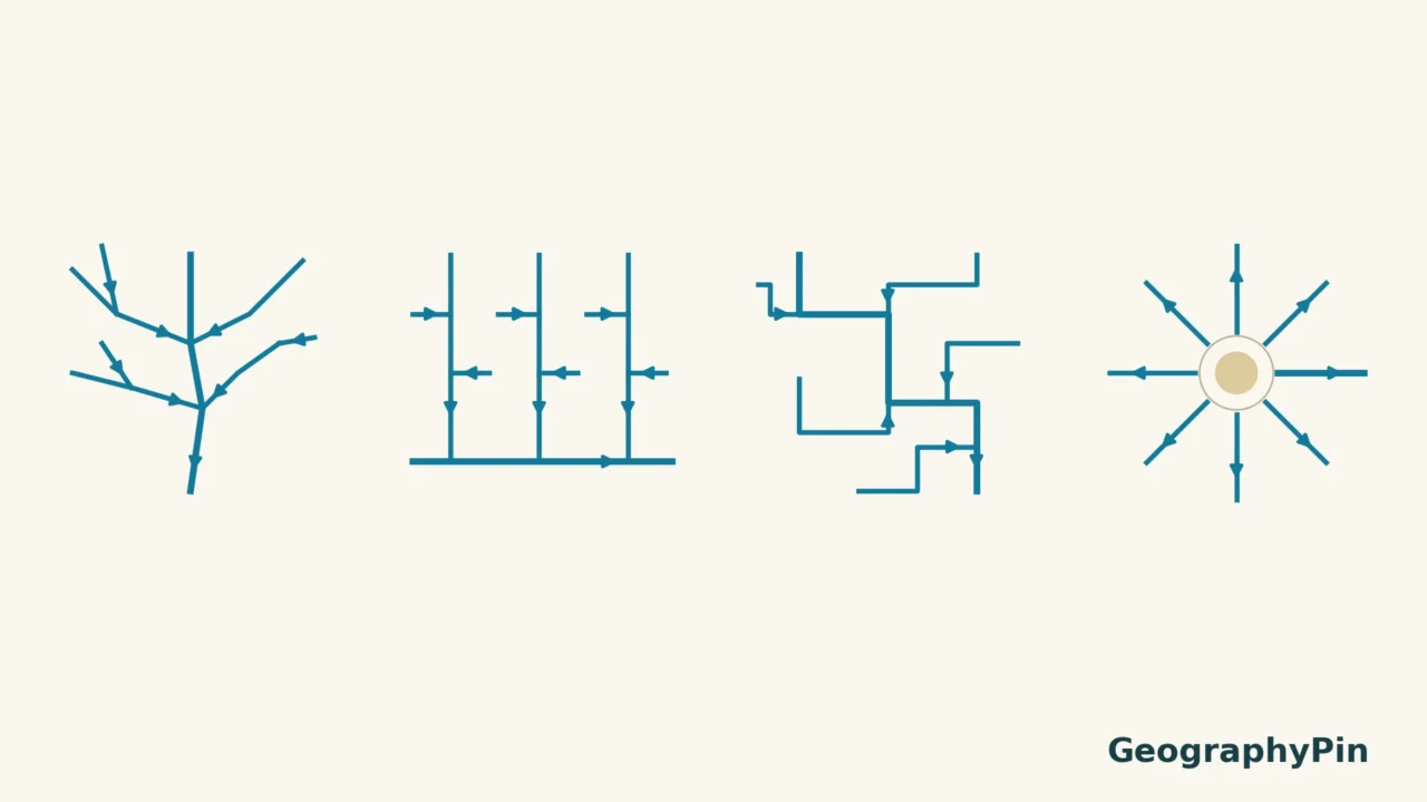
A river network can resemble a tree, a ladder or the spokes of a wheel. Those shapes help describe how streams are arranged across a landscape. They can also suggest where relief and rock structure guide drainage, but the pattern alone does not prove what lies underground.
Dendritic drainage branches like a tree. Trellis drainage has prominent, roughly parallel streams linked by shorter tributaries. Rectangular drainage contains repeated angular channel bends. Radial drainage flows outward from a central high. These are descriptions of network geometry, not unique diagnoses of rock type, and real landscapes can combine patterns.
Choose your comparison: Separate trellis from rectangular drainage, check radial flow direction, or use the identification checklist.
1. What a drainage pattern describes
A drainage pattern is the arrangement of channels seen from above. It describes the network, not just whether one stretch of river is straight or meandering. Tributary orientation, junctions and the directions of channel segments all contribute to the classification.
A drainage basin is different: it is the area contributing water to an outlet. The network lies within that area, but its branching shape is not the basin boundary. Our river and drainage-basin guide explains the basic distinction.
The four diagrams below are idealized illustrations, not traced maps of real places. Their arrows show downstream direction, not speed or discharge. No north direction is implied: rotate the drawing and its classification stays the same.
2. Dendritic: branching like a tree
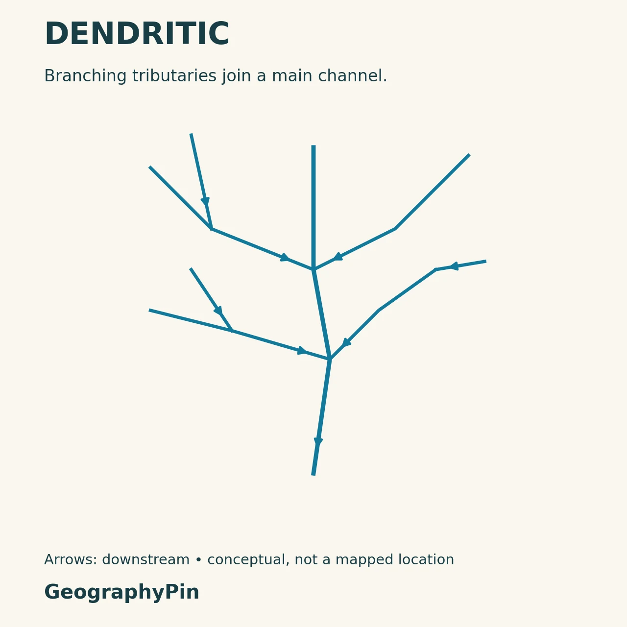
Dendritic networks have irregular branches joining larger channels in a tree-like arrangement. Tributaries commonly meet at acute angles, rather than repeatedly following a strong grid. This is the familiar form many people imagine when they draw a river system.
The pattern often develops where the underlying material offers broadly similar resistance to erosion, so a dominant set of structural lines does not strongly direct every channel. That does not mean the ground is perfectly uniform or that geology has no influence.
Different tributary sizes still fit one dendritic network. To label the branching hierarchy, use Strahler stream order. Order and pattern answer different questions: one assigns a network rank, while the other describes its layout.
3. Trellis: parallel valleys and cross-connections
Follow the parallel valley alignment
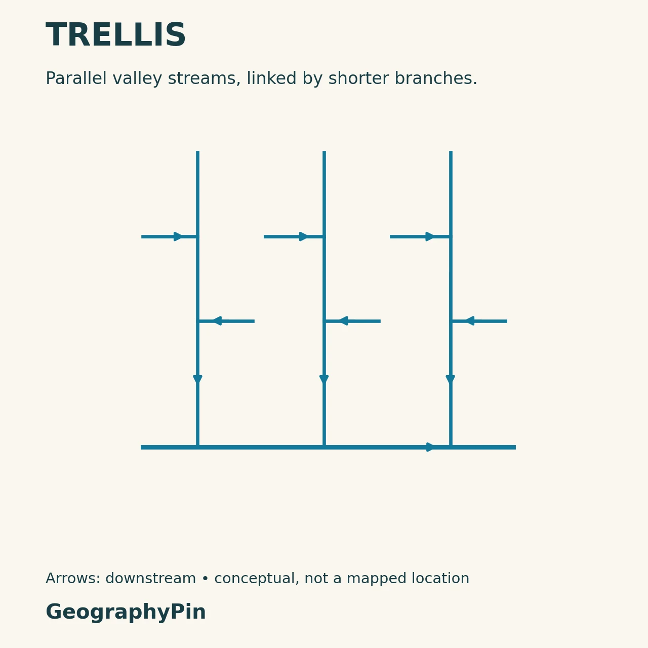
A trellis network has a strong directional grain: longer streams follow roughly parallel valleys, with shorter tributaries feeding in across that grain. The arrangement resembles a garden trellis or a ladder. Near-right-angle connections are common, although natural channels do not follow a ruler.
Alternating belts of more and less resistant rock can help establish this pattern. Streams develop along easier-to-erode valleys, while more resistant material helps maintain intervening ridges.
The National Park Service identifies trellis drainage in the Appalachian Valley and Ridge province, where folded and tilted sedimentary layers shape repeated ridges and valleys. That is a documented example, not a claim that every trellis-like network proves the same folding history.
4. Rectangular: angular bends in the channels
Look for repeated bends within channels
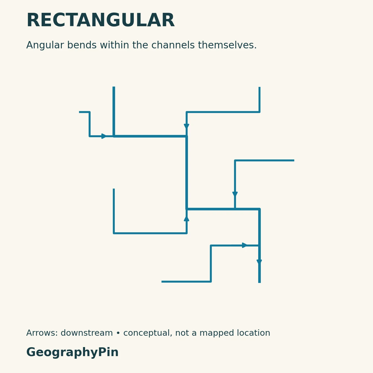
In rectangular drainage, streams repeatedly make sharp, roughly right-angle turns. Joints, faults or other zones of weakness can provide intersecting pathways that the channels exploit.
Do not identify this pattern from the angle at a single confluence. A trellis network can also contain near-right-angle junctions. The stronger clue for rectangular drainage is repeated angular channel segments across the network, rather than mainly long parallel valleys.
USGS describes rectangular drainage influenced by highly fractured faults in the Gainesville Ridges District of the Apalachicola–Chattahoochee–Flint study area. The example shows why stream maps can provide geological clues, but a geological map or field evidence is needed before assigning a specific structure to a new location.
5. Radial: away from a central high
Check whether flow moves away from the high
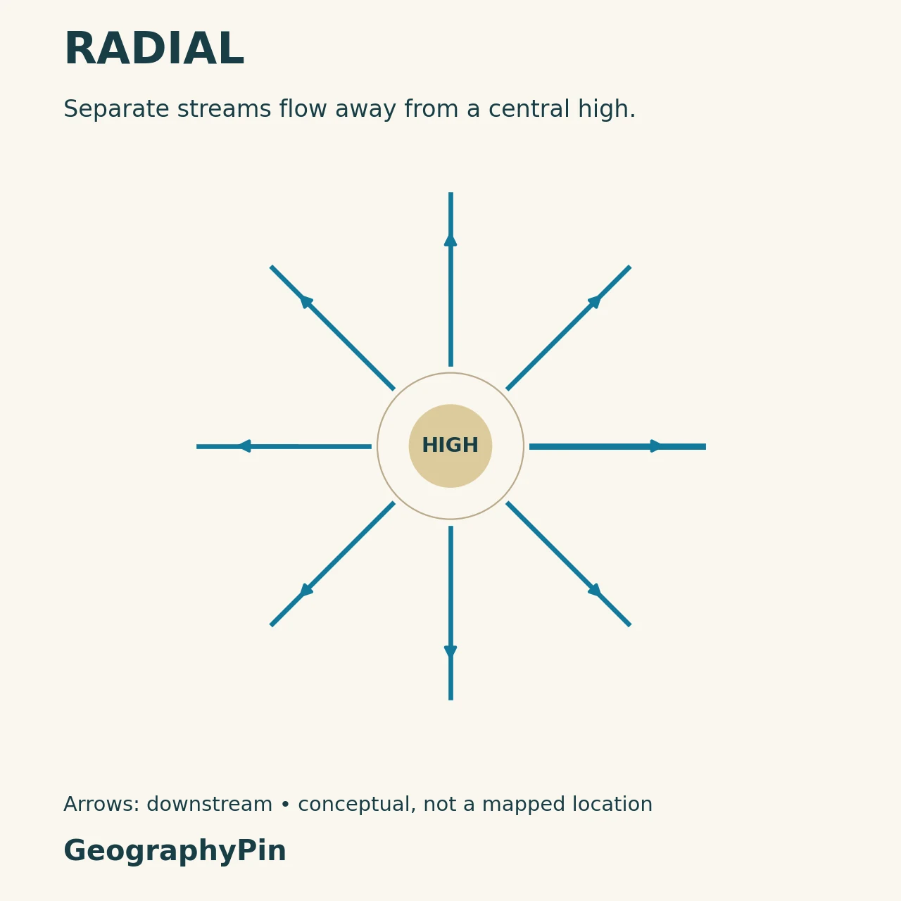
Radial drainage spreads away from a central elevated area. A volcanic cone is a familiar setting, but a dome or another suitable topographic high can also produce outward-draining streams. The key is the slope away from the center, not proof that a volcano is active or even present.
This arrangement may span several drainage basins. Unlike the dendritic example, the illustrated streams do not combine into one trunk. Each runs away from the high toward a different part of the surrounding landscape.
Reverse those arrows and you describe a different arrangement: centripetal drainage converges toward a central low. An unlabeled wheel-shaped sketch is therefore incomplete until you know which way the water moves.
6. How to identify a pattern without guessing the geology
Use direction, scale and supporting evidence
- Establish flow direction. Use relief, contours, channel connections or reliable directional data, not the top and bottom of the page.
- Look beyond one bend. Classification describes a network or a meaningful part of one.
- Compare the strongest features. Irregular branching suggests dendritic; parallel valley alignment suggests trellis; repeated angular turns suggest rectangular; outward flow from a high suggests radial.
- Check the map scale. A small map may omit minor channels that would clarify the pattern.
- Separate description from explanation. Compare the stream pattern with topography and geology before claiming a cause.
These four types are not the entire vocabulary of drainage patterns. They are useful starting points, and a real landscape may be transitional, composite or poorly represented by one ideal label. Saying “mostly dendritic with locally angular reaches” can be more accurate than forcing every tributary into one category.
Frequently Asked Questions
Does a right-angle junction always mean rectangular drainage?
No. Trellis networks can also have near-right-angle connections. Examine the repeated shape of channel paths and the overall alignment of the valleys.
Is radial drainage one river splitting into many?
Not necessarily. The classic pattern consists of separate streams draining away from a topographic high. It does not require a single river arriving at the center and dividing there.
Can one river basin contain more than one drainage pattern?
Yes. Relief and geological controls can change across the basin, and the pattern visible at one scale may differ from the detail seen in a smaller sub-basin.
What Did We Learn Today?
Drainage patterns describe how channels fit together. Branching, parallel alignment, angular turns and outward flow provide four useful visual clues. Read them with flow direction and map scale in mind, then test any geological explanation against additional evidence. A pattern name is a description, not a complete history of the landscape.
Sources & Data Notes
Original GeographyPin diagrams illustrate network geometry only. They contain no observed river coordinates, measured slopes, channel widths or discharge values. The named regional examples come from NPS and USGS descriptions, not from the schematic drawings.
- Steven Earle, Physical Geology: Drainage Basins
- National Park Service: Valley and Ridge Province
- USGS: ACF River NAWQA study, physiographic setting
- USDA-NRCS: Soil Survey Manual (2017), Chapter 2 — drainage-pattern vocabulary, pages 51–52 and Figure 2-20; source figure not reproduced.