A mountain can have a high summit but little topographic prominence. Another, lower peak can stand much more independently above the terrain connecting it to higher mountains. The difference is not a contradiction: elevation and prominence answer different questions.
Elevation measures a summit’s height above a vertical reference, commonly described as sea level. Topographic prominence measures the summit’s rise above its key col: the controlling saddle connecting it to higher terrain. Subtract the col’s elevation from the summit’s elevation. Neither measurement equals the total uphill distance on a hiking route.
How to use this article: Identify the controlling saddle, follow the calculation, or understand why one side view is insufficient.
1. Elevation and prominence use different reference levels
For elevation, imagine reading the height assigned to the summit on a topographic map. For prominence, ask how far below that summit the terrain must fall before it connects to something higher. Both are vertical measurements, but they start from different reference levels.
| Question | Elevation | Prominence |
|---|---|---|
| Reference | An adopted vertical datum | The summit’s key col |
| What it describes | Height in a shared reference system | Vertical separation from higher terrain |
| What it does not measure | Height climbed from your trailhead | Route length or cumulative ascent |
“Above sea level” is useful everyday shorthand, but accurate elevation work uses a defined vertical datum. NOAA explains that vertical datums provide reference surfaces for heights. Compare summit and saddle elevations expressed in compatible units and the same reference system, rather than subtracting unrelated numbers from different sources.
2. How the key col controls prominence
Not just the nearest saddle
A col, or saddle, is a low point along a ridge between higher ground. A peak may connect to other peaks through several saddles. The key col is not whichever saddle happens to be closest, easiest to walk to or most obvious in a photograph.
For a summit with higher terrain on the same landmass, consider every possible terrain connection to something higher. Along each connection, identify its lowest point. The connection whose lowest point is highest determines the key-col level. This is why prominence is often described as the minimum vertical drop needed before reaching higher terrain.
The word “minimum” matters. Choosing a route through an unnecessarily deep valley would exaggerate prominence. The calculation is about the terrain’s connectivity, not the route a particular walker decides to follow.
A useful thought experiment is to raise an imaginary water surface around the peak. At the key-col level, the peak’s high ground separates from the higher terrain. The summit’s height above that level is its prominence. This is an explanatory analogy, not a flood-risk forecast or a statement about actual sea-level change.
The Relative Hills Society uses this relationship to distinguish hills by their rise relative to neighboring higher terrain. The result can identify a modest but independent hill that would disappear from a list based only on absolute summit elevation.
3. A worked example with two different rankings
Subtract the saddle, then compare like with like
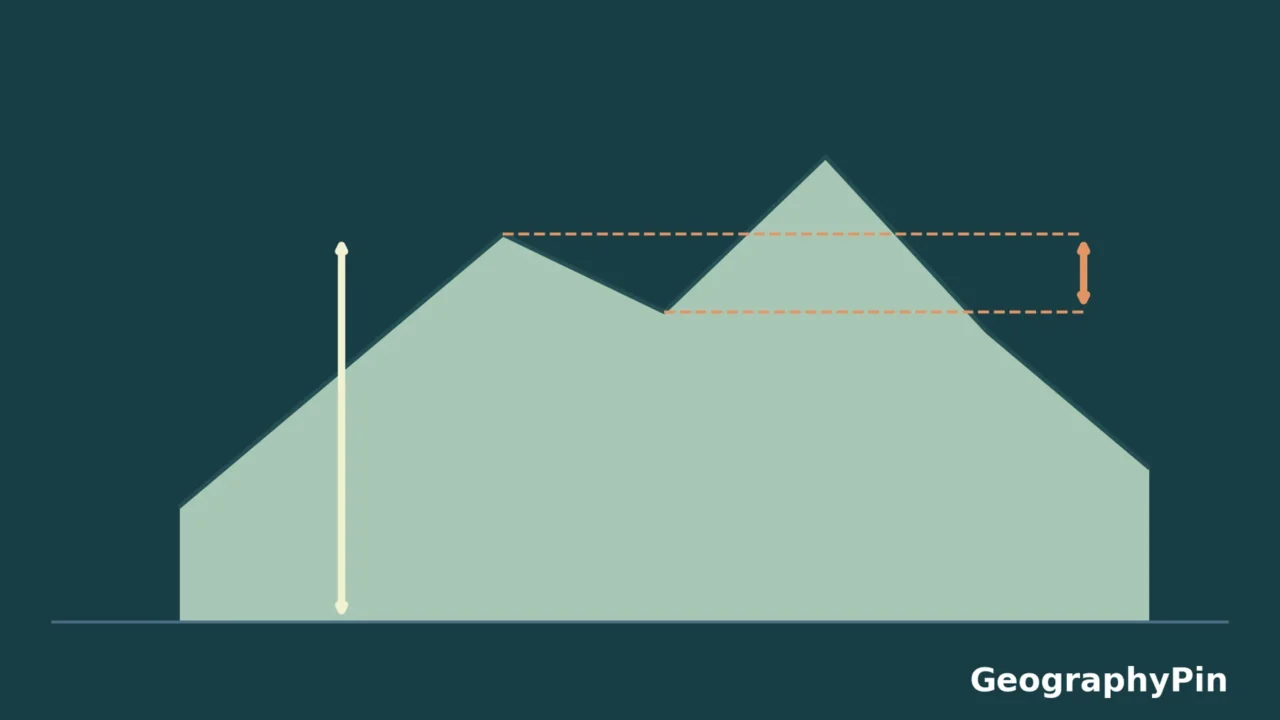
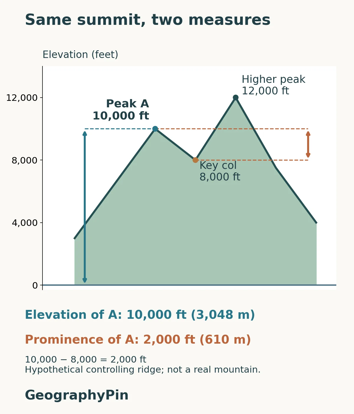
In the fictional diagram, Peak A’s elevation is 10,000 feet (3,048 m). Its key col is 8,000 feet (about 2,438 m). Its prominence is therefore:
10,000 − 8,000 = 2,000 feet (about 610 m).
The 12,000-foot (about 3,658 m) higher peak tells us that A is not the highest summit in the modeled terrain. We do not subtract that higher peak’s elevation. The subtraction uses the col, because it is the connecting low point that establishes A’s independent rise.
Now consider a separate hypothetical Peak C, not shown in the diagram. Suppose its summit is 9,000 feet (about 2,743 m) and its verified key col is 5,000 feet (1,524 m). Its prominence is 4,000 feet (about 1,219 m). C is lower than A in elevation but has twice its prominence.
This is the practical reason the two rankings can disagree. Ranking by elevation selects the highest summits relative to the datum. Ranking by prominence selects the greatest rises above controlling connections. Neither ranking is a universal measure of beauty, climbing difficulty or geological importance.
Metric equivalents here are rounded from the original feet using 1 foot = 0.3048 m. Calculate with consistent original values before rounding: differences between independently rounded conversions can otherwise be confusing.
4. Why a map or hike can give the wrong impression
A single profile does not establish the key col
A side view is excellent for teaching the subtraction, but an arbitrary line across a real mountain cannot prove its prominence. A higher connecting saddle may lie outside that line, and the relevant connection can extend far beyond the summit’s immediate neighborhood.
Andrew Kirmse’s account of computing prominence from terrain data describes the need to handle networks of peaks and saddles over large areas. A tightly cropped map can miss the controlling connection. Data resolution also matters: a grid may not represent the exact summit or saddle elevation.
Our guide to reading a topographic profile explains how a side view represents one chosen line and how vertical scale changes its appearance. Use a profile to understand a measured relationship, not to assume that everything beyond the line is irrelevant.
Prominence is also different from a hike’s total ascent. A trail may start above or below the key col, wander across several dips, or approach from another side. Adding every uphill segment measures cumulative ascent along that route. It does not measure the peak’s topographic prominence.
When evaluating a quoted prominence, look for the summit elevation, the key-col identification and the underlying data or survey. An unexplained number with extra decimal places is not necessarily better evidence. If the col is uncertain, the prominence is uncertain too.
Frequently Asked Questions
Is topographic isolation the same as prominence?
No. Isolation describes horizontal distance to higher terrain. Prominence is a vertical height difference relative to a key col. A peak’s nearest higher point need not identify the controlling saddle used for prominence.
What if a peak is the highest point on an island?
Under the usual landmass convention, the island’s highest summit has prominence equal to its elevation above sea level. There is no higher summit on that island to connect to by land. This special case differs from an ordinary subsidiary summit with a key col above sea level.
What Did We Learn Today?
A summit’s elevation and prominence share a vertical dimension but not a starting point. The key col explains why a lower mountain can be more prominent, while the worked example makes the subtraction explicit. Real prominence requires surrounding terrain, not just a dramatic skyline or one hiking route. Keep the reference, the controlling connection and the data quality in view.
Sources & Data Notes
The GeographyPin diagram and numerical examples are original, explicitly hypothetical teaching material. They do not represent surveyed mountains, actual routes or a digital elevation model. Peak A’s key-col status is stipulated; a real-world calculation would require the relevant surrounding terrain. Metric equivalents are rounded from feet. No real summit ranking or precise measured prominence is presented.
- USGS: EarthWord — Prominence — introductory distinction between summit elevation and relative rise.
- NOAA: What is a datum? — vertical reference systems.
- Andrew Kirmse: Topographic Prominence — definitions, terrain connectivity, isolation and computational context.
- Relative Hills Society: Prominence of Hills — summit–col relationships and the island-highpoint convention.