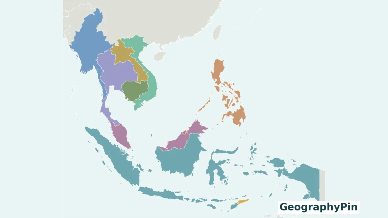
Southeast Asia is not just a peninsula or a chain of islands. It includes both, which makes a country map more useful than a simple north-to-south list. Start with the mainland, then follow the islands toward the Philippines, Indonesia and Timor-Leste.
Using the United Nations M49 South-eastern Asia grouping, Southeast Asia contains 11 countries: Brunei, Cambodia, Indonesia, Laos, Malaysia, Myanmar, the Philippines, Singapore, Thailand, Timor-Leste and Vietnam. The region combines mainland and island settings. Malaysia spans both, while small countries such as Singapore need close-up maps to remain visible.
Use this guide: Check the complete list, understand Malaysia’s two main regions, or inspect Singapore and Timor-Leste.
1. Southeast Asia countries map
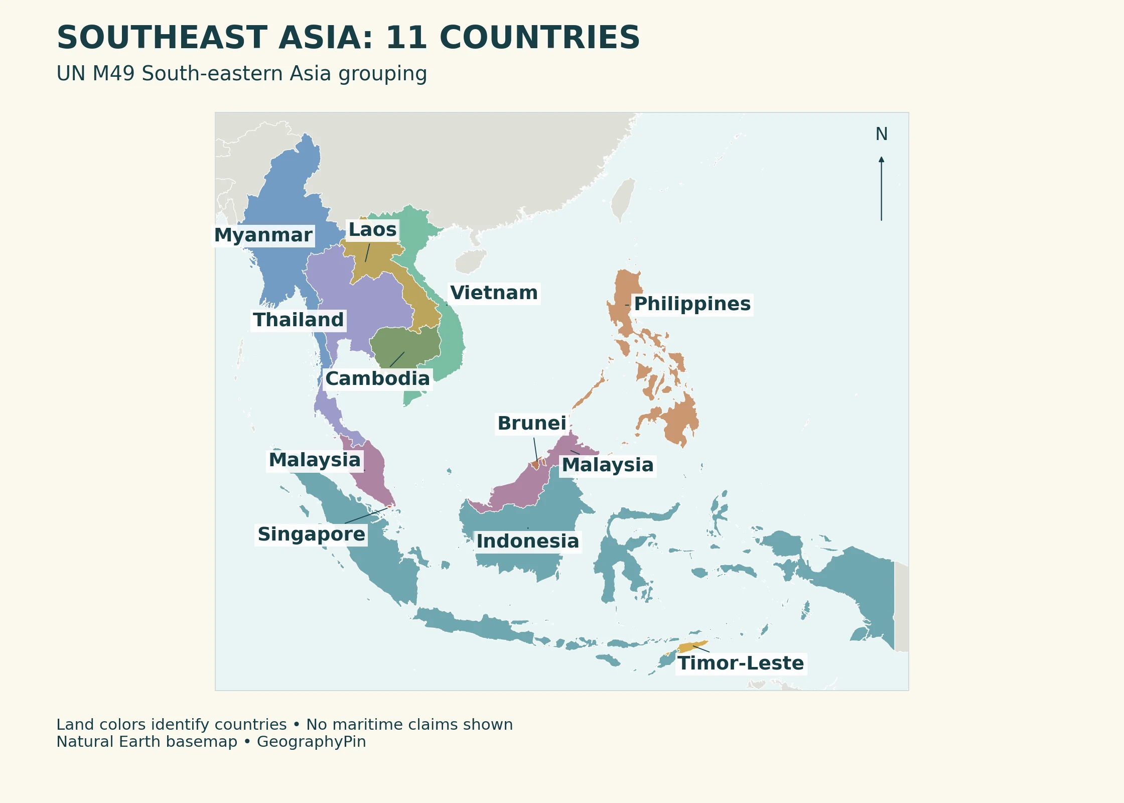
The mainland occupies the northwestern part of the map. Myanmar lies to the west, Vietnam follows the eastern coast, and Thailand, Laos and Cambodia occupy the intervening mainland area. Farther south, the Malay Peninsula reaches toward Singapore and the Indonesian archipelago.
Look east across the water to Borneo, the Philippines and the island chains of Indonesia. Timor-Leste lies near the southeastern end of this regional view. For a closer look at one archipelago, use our Philippines location map.
2. List of the 11 countries
The complete list, with map cues
| Country | UN M49 code | Where to look |
|---|---|---|
| Brunei | 096 | On the island of Borneo |
| Cambodia | 116 | Mainland Southeast Asia |
| Indonesia | 360 | Archipelago extending across many islands |
| Laos | 418 | Landlocked country on the mainland |
| Malaysia | 458 | Malay Peninsula and northern Borneo |
| Myanmar | 104 | Western side of mainland Southeast Asia |
| Philippines | 608 | Archipelago east of Vietnam |
| Singapore | 702 | Island state off the Malay Peninsula’s southern tip |
| Thailand | 764 | Mainland, extending south along the Malay Peninsula |
| Timor-Leste | 626 | Eastern Timor, Oecusse and nearby islands |
| Vietnam | 704 | Eastern coast of the mainland |
The table uses familiar English names. The UN list uses “Brunei Darussalam,” “Lao People’s Democratic Republic” and “Viet Nam.” These are naming differences, not additional countries. Keep the leading zero in Brunei’s three-digit M49 code when importing the list into a spreadsheet.
Country codes make the inclusion rule reproducible. They are identifiers, not a ranking by area, population or importance. For the wider continent, see the Asia countries and capitals guide.
3. Mainland and island Southeast Asia
“Mainland” and “maritime” or “island” Southeast Asia are useful orientation terms, but they should not force every country into an oversimplified box. Myanmar, Thailand, Laos, Cambodia and Vietnam are associated with the mainland. Brunei, Indonesia, the Philippines, Singapore and Timor-Leste occupy island settings.
Malaysia spans both settings
Peninsular Malaysia is on the Malay Peninsula, south of Thailand. East Malaysia lies on and around northern Borneo, including Sabah, Sarawak and Labuan. The South China Sea separates the two main regions. Malaysia is therefore labeled twice on the map but counted only once in the country list.
Borneo is an island, not a country. Its land is shared by Indonesia, Malaysia and Brunei. Likewise, Timor is not synonymous with Timor-Leste: the island is shared by Timor-Leste and Indonesia. Island names and sovereign-country names answer different questions.
4. Singapore and Timor-Leste in close-up
Small on a regional map does not mean unimportant
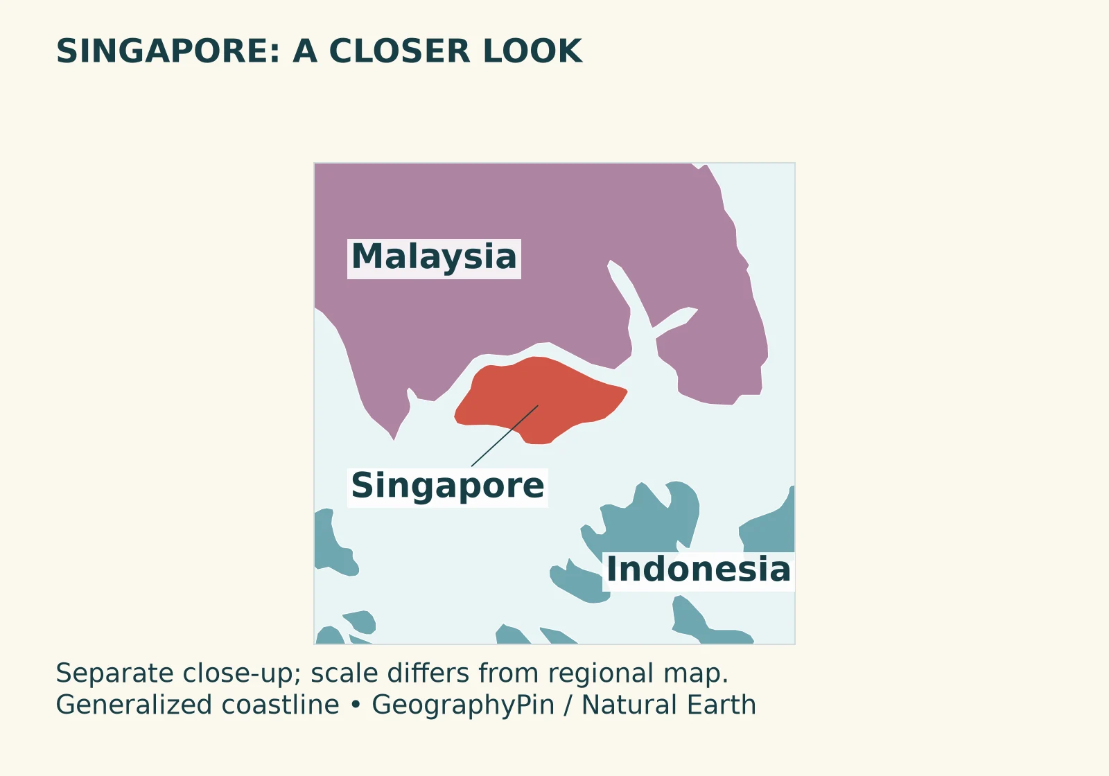
Singapore’s Ministry of Foreign Affairs identifies it as an island state off the Malay Peninsula’s southern tip. At the regional map’s scale, its land is difficult to see without a leader label. The close-up preserves the coastline rather than drawing an oversized dot and presenting that dot as the country’s boundary.
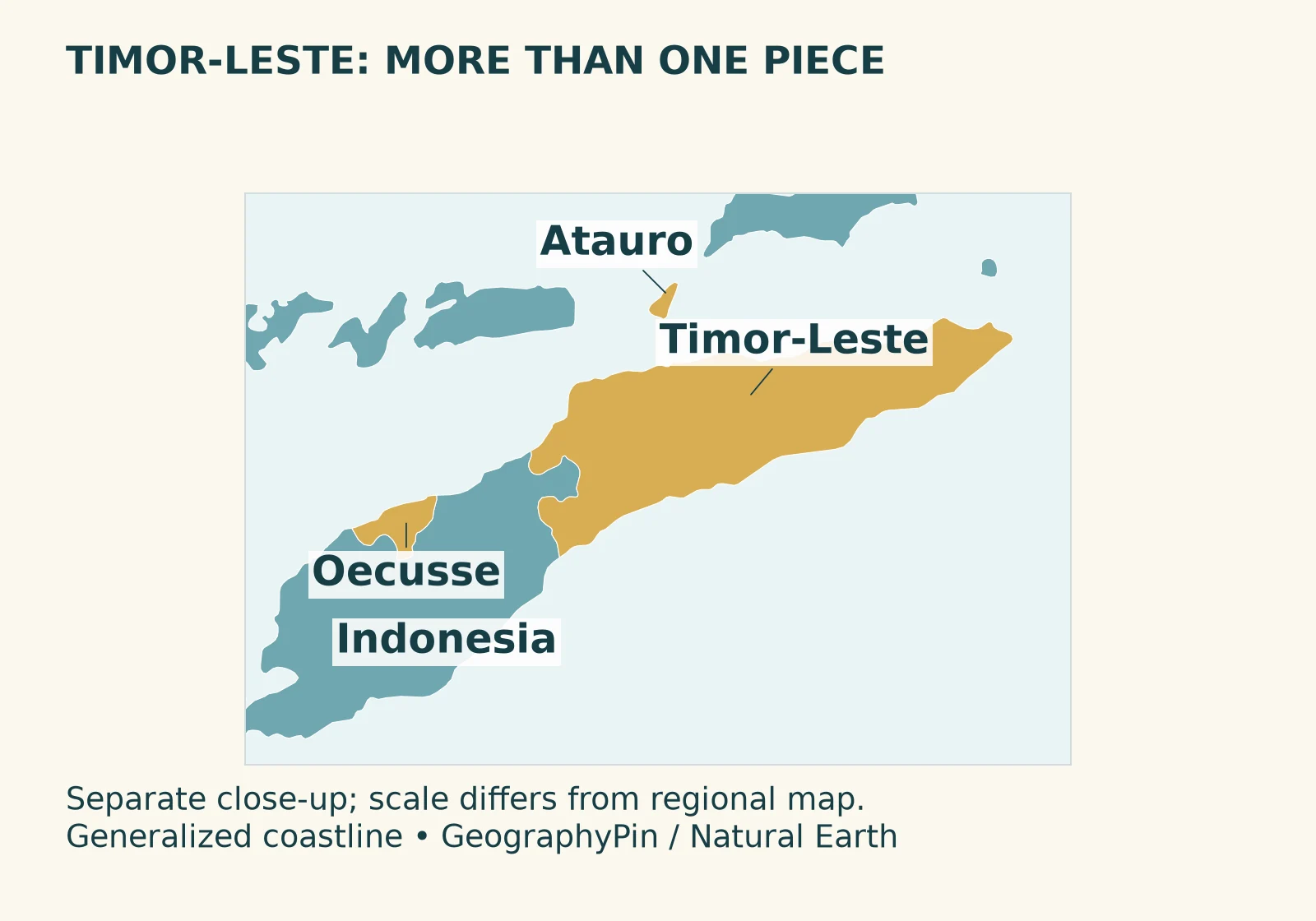
Timor-Leste’s government describes its territory as eastern Timor, Oecusse on the northwestern side of the island, Atauro and Jaco. Oecusse is separated from the country’s main territory by Indonesian land; it must not disappear simply because a small map labels only eastern Timor. These close-ups are educational references, not detailed border surveys or navigation charts.
5. How to read the regional boundary
This article follows a statistical regional grouping, not a line enclosing all the seas between the countries. UN M49 explicitly says that regional assignments are for statistical convenience and do not imply a political affiliation. The map’s land colors should therefore not be read as territorial-sea limits or exclusive economic zones.
A country can also straddle a physical or biogeographical transition while being assigned to one statistical region. Indonesia’s inclusion here does not require pretending that all its islands share identical geology, ecosystems or continental context.
ASEAN is an organization, whereas Southeast Asia is a region. This guide uses the UN regional list, not an organization’s membership count. If you need treaty membership or accession dates, consult the organization’s current official records rather than inferring them from a geographic map.
Frequently Asked Questions
Is Timor-Leste part of Southeast Asia?
Yes. UN M49 lists Timor-Leste in South-eastern Asia, and it is included in this 11-country list.
Why does Malaysia appear twice on the map?
Its territory has two main regions: Peninsular Malaysia and East Malaysia on and around Borneo. Both labels refer to one sovereign state.
Is Borneo a Southeast Asian country?
No. Borneo is an island shared by Indonesia, Malaysia and Brunei. The three countries are listed separately; the island is not an extra country.
Which Southeast Asian country is landlocked?
Laos is the landlocked country in this regional list. The other 10 countries have coastlines.
What Did We Learn Today?
The UN M49 grouping provides a clear 11-country list for Southeast Asia. Reading it well means distinguishing islands from countries, counting Malaysia once despite its two regions, and using close-ups for small or separated territories. A regional map is not a map of maritime claims or organizational membership.
Sources & Data Notes
Country inclusion and codes follow UN M49. Original GeographyPin maps use Natural Earth 1:10 million country geometry; coastlines and small islands are generalized. Close-up scales differ from the regional map. No maritime claims, population estimates or changing capital-city claims are added. Official country pages are used for stable location and territorial descriptions, not their older statistics.