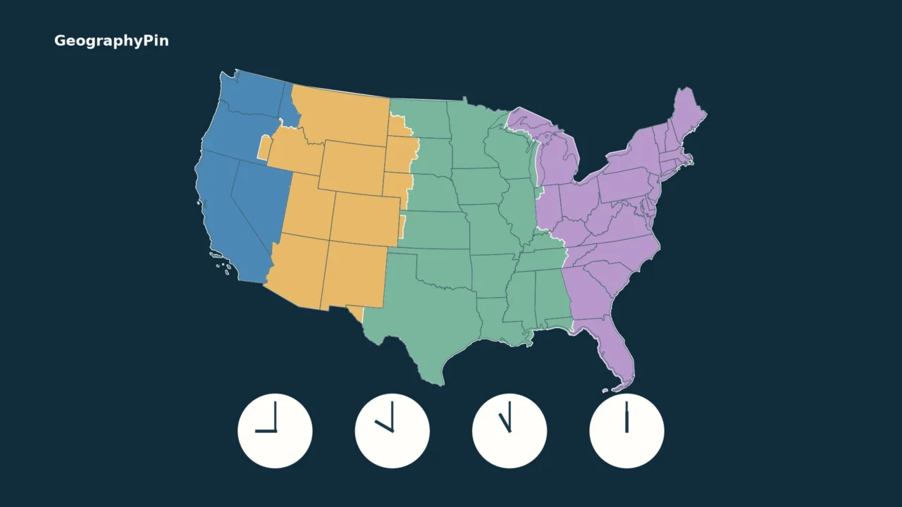
A US time zones map answers one question: which geographic time zone is a place in? To know its clock time, you also need a second answer: does that place observe daylight saving time on the date you are checking?
The United States has nine legally defined standard time zones, including its inhabited territories. Six cover the 50 states, while four cover the contiguous states: Eastern, Central, Mountain and Pacific. Most places advance their clocks one hour during daylight saving time, but Hawaii, most of Arizona and the inhabited US territories do not.
For a state lookup, use the alphabetical table below. For seasonal exceptions, jump to Arizona, Hawaii or Alaska. This is a geographic reference, not a live clock or an address-level lookup.
1. How to read the map
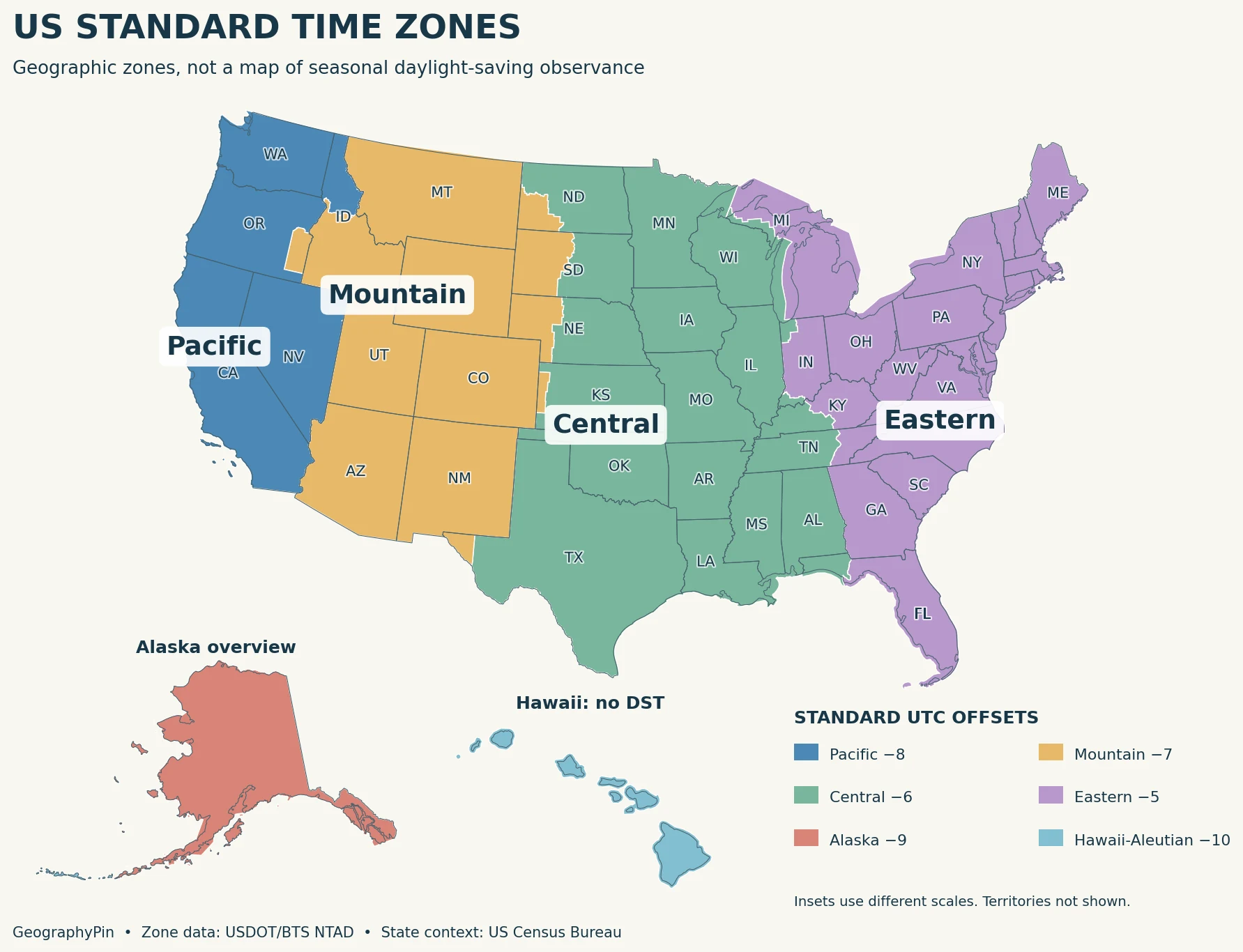
The four contiguous-US zones generally progress from Pacific in the west to Eastern in the east. Moving one zone east normally puts the clock one hour ahead when both places follow the same seasonal rule. Alaska and Hawaii add two more standard zones across the 50 states.
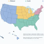
The colored boundaries come from the US Department of Transportation’s time-zone data, not from drawing straight lines through state capitals. Legal boundaries may follow county lines, rivers or other described features. Fourteen states intersect two legal standard time zones. A large-scale national map cannot show every small exception clearly.
Thin lines provide state context. They are not always time-zone boundaries: Texas, for example, contains both Central and Mountain areas. For state names and capitals without the time-zone layer, see our US states map. Our guide to why time-zone borders zigzag explains why civil time does not follow a simple longitude grid.
Important: Arizona stays Mountain-colored on this map even when Phoenix and Los Angeles show the same time. Matching clocks does not mean the two places share the same standard geographic zone.
2. Standard and daylight UTC offsets
UTC is the reference used to express time offsets. UTC−5 means five hours behind UTC; UTC+10 means ten hours ahead. Where daylight saving time applies, the clock advances one hour, making the offset one hour less negative.
| Standard zone | Standard time | Daylight time where observed |
|---|---|---|
| Atlantic | AST · UTC−4 | US Atlantic territories do not observe DST |
| Eastern | EST · UTC−5 | EDT · UTC−4 |
| Central | CST · UTC−6 | CDT · UTC−5 |
| Mountain | MST · UTC−7 | MDT · UTC−6; most Arizona remains MST |
| Pacific | PST · UTC−8 | PDT · UTC−7 |
| Alaska | AKST · UTC−9 | AKDT · UTC−8 |
| Hawaii–Aleutian | HST · UTC−10 | HDT · UTC−9 in the western Aleutians; Hawaii remains HST |
| Samoa | SST · UTC−11 | No DST in American Samoa |
| Chamorro | ChST · UTC+10 | No DST in Guam or the Northern Mariana Islands |
Under the federal rule, participating places move forward at 2 a.m. local time on the second Sunday in March and move back at 2 a.m. local time on the first Sunday in November. The spring change skips an hour; the fall change repeats an hour. That is why a date and a location matter when interpreting a timestamp around a clock change.
ET is not always EST. ET is a general label for Eastern Time; EST specifically means Eastern Standard Time. An appointment in New York during daylight saving time is on EDT, not EST. The same distinction applies to PT versus PST or PDT. For a calendar invitation, selecting a city-based time zone is safer than typing a fixed abbreviation.
3. Time zones by state
The table follows federal standard-zone boundaries. Unless noted otherwise, states observe daylight saving time. Descriptions of split states are geographic summaries, not a replacement for the full legal boundary. The District of Columbia, which is not a state, uses Eastern Time and observes daylight saving time.
| State | Zone or zones | Boundary or seasonal note |
|---|---|---|
| Alabama | Central | Statewide zone; observes daylight saving time. |
| Alaska | Alaska / Hawaii–Aleutian | Most of the state: Alaska. Aleutian Islands west of 169°30′W: Hawaii–Aleutian. |
| Arizona | Mountain | Mountain Standard Time year-round in most of the state; the Navajo Nation observes daylight saving time. Hopi does not. |
| Arkansas | Central | Statewide zone; observes daylight saving time. |
| California | Pacific | Statewide zone; observes daylight saving time. |
| Colorado | Mountain | Statewide zone; observes daylight saving time. |
| Connecticut | Eastern | Statewide zone; observes daylight saving time. |
| Delaware | Eastern | Statewide zone; observes daylight saving time. |
| Florida | Eastern / Central | Most of the state: Eastern; western Panhandle areas: Central. The legal boundary follows rivers and other features, not simply the entire Panhandle. |
| Georgia | Eastern | Statewide zone; observes daylight saving time. |
| Hawaii | Hawaii–Aleutian | Hawaii Standard Time year-round; no daylight saving time. |
| Idaho | Mountain / Pacific | Northern areas: Pacific; southern areas: Mountain. The boundary follows part of the Salmon River and splits Idaho County. |
| Illinois | Central | Statewide zone; observes daylight saving time. |
| Indiana | Eastern / Central | Most counties: Eastern; designated northwestern and southwestern counties: Central. |
| Iowa | Central | Statewide zone; observes daylight saving time. |
| Kansas | Central / Mountain | Sherman, Wallace, Greeley and Hamilton counties: Mountain; the rest: Central. |
| Kentucky | Eastern / Central | Eastern areas: Eastern; western areas: Central. Use the federal boundary for a particular locality. |
| Louisiana | Central | Statewide zone; observes daylight saving time. |
| Maine | Eastern | Statewide zone; observes daylight saving time. |
| Maryland | Eastern | Statewide zone; observes daylight saving time. |
| Massachusetts | Eastern | Statewide zone; observes daylight saving time. |
| Michigan | Eastern / Central | Gogebic, Iron, Dickinson and Menominee counties: Central; the rest: Eastern. |
| Minnesota | Central | Statewide zone; observes daylight saving time. |
| Mississippi | Central | Statewide zone; observes daylight saving time. |
| Missouri | Central | Statewide zone; observes daylight saving time. |
| Montana | Mountain | Statewide zone; observes daylight saving time. |
| Nebraska | Central / Mountain | Eastern areas: Central; western areas: Mountain. Some boundary segments do not follow county lines. |
| Nevada | Pacific / Mountain | West Wendover: Mountain; the remainder is legally Pacific. This table follows federal boundaries rather than informal local practice. |
| New Hampshire | Eastern | Statewide zone; observes daylight saving time. |
| New Jersey | Eastern | Statewide zone; observes daylight saving time. |
| New Mexico | Mountain | Statewide zone; observes daylight saving time. |
| New York | Eastern | Statewide zone; observes daylight saving time. |
| North Carolina | Eastern | Statewide zone; observes daylight saving time. |
| North Dakota | Central / Mountain | Most of the state: Central; southwestern areas: Mountain. Mercer County is Central. |
| Ohio | Eastern | Statewide zone; observes daylight saving time. |
| Oklahoma | Central | Statewide zone; observes daylight saving time. |
| Oregon | Pacific / Mountain | Most of the state: Pacific; much of Malheur County: Mountain. Do not treat all of Malheur County as Mountain. |
| Pennsylvania | Eastern | Statewide zone; observes daylight saving time. |
| Rhode Island | Eastern | Statewide zone; observes daylight saving time. |
| South Carolina | Eastern | Statewide zone; observes daylight saving time. |
| South Dakota | Central / Mountain | Eastern areas: Central; western areas: Mountain. Use the legal boundary for an exact locality. |
| Tennessee | Eastern / Central | Eastern areas: Eastern; central and western areas: Central. |
| Texas | Central / Mountain | El Paso and Hudspeth counties: Mountain; the rest: Central. |
| Utah | Mountain | Statewide zone; observes daylight saving time. |
| Vermont | Eastern | Statewide zone; observes daylight saving time. |
| Virginia | Eastern | Statewide zone; observes daylight saving time. |
| Washington | Pacific | Statewide zone; observes daylight saving time. |
| West Virginia | Eastern | Statewide zone; observes daylight saving time. |
| Wisconsin | Central | Statewide zone; observes daylight saving time. |
| Wyoming | Mountain | Statewide zone; observes daylight saving time. |
Arizona is not counted among the 14 states split between two standard geographic zones. Its complication is different daylight-saving observance within the Mountain zone. Nevada is counted because the federal boundary places West Wendover in Mountain Time, even though that small area is hard to see on a national overview.
4. Arizona, Hawaii and Alaska exceptions
Arizona: Mountain Time with different seasonal rules
Phoenix and Tucson use Mountain Standard Time, UTC−7, throughout the year. The Navajo Nation observes daylight saving time, including its Arizona portion. The Hopi Nation does not. These rules create a more complicated pattern than a single statewide “Arizona does not change clocks” label suggests.
During daylight saving time, Phoenix and Los Angeles both use UTC−7, while Denver uses UTC−6. During standard time, Phoenix and Denver both use UTC−7, while Los Angeles uses UTC−8. Phoenix has not moved between Mountain and Pacific zones; other places have changed their seasonal offsets. Confirm local operating hours with the specific business or attraction when traveling through northeastern Arizona.
Hawaii: no seasonal clock change
Hawaii stays at UTC−10. It is two hours behind Los Angeles when California is on Pacific Standard Time and three hours behind when California is on Pacific Daylight Time. The name Hawaii–Aleutian does not mean that every place in the zone follows Hawaii’s no-DST rule.
Alaska: two zones, both with daylight saving time
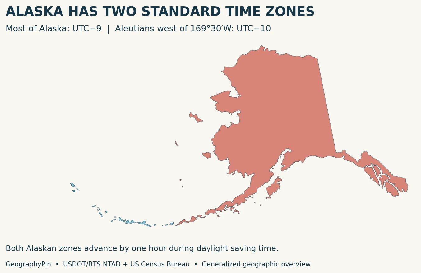
Most of Alaska uses Alaska Standard Time, UTC−9, changing to UTC−8 during daylight saving time. The Aleutian Islands west of 169°30′ west longitude use Hawaii–Aleutian Standard Time, UTC−10, changing to UTC−9 during daylight saving time. The state should therefore not be labeled as one uniform time zone.
5. US territories and time differences
The nine-zone legal count includes the inhabited US territories. These territories do not appear on the 50-state map, so use this table rather than assuming an island’s zone from its position on a mainland map.
| Territory | Standard zone | Year-round UTC offset |
|---|---|---|
| Puerto Rico | Atlantic | UTC−4 |
| US Virgin Islands | Atlantic | UTC−4 |
| American Samoa | Samoa | UTC−11 |
| Guam | Chamorro | UTC+10 |
| Northern Mariana Islands | Chamorro | UTC+10 |
None of the five territories in the table observes daylight saving time. Puerto Rico therefore matches New York’s clock during Eastern Daylight Time, but is one hour ahead during Eastern Standard Time. American Samoa should not be confused with the independent country of Samoa, which is not covered by this table.
For a quick contiguous-US example, when it is noon in New York, it is 11 a.m. in Chicago, 10 a.m. in Denver and 9 a.m. in Los Angeles under their usual matching seasonal schedules. Do not automatically extend that shortcut to Arizona, Hawaii or the territories: their differences from DST-observing cities can change seasonally.
To calculate a specific difference, identify both places’ offsets on the relevant date and subtract them. At the same instant, UTC−4 is three hours ahead of UTC−7. Across large Pacific differences, also check the calendar date; equal-looking clock times alone do not establish that two places are on the same day.
Frequently asked questions
Does the US have four, six or nine time zones?
All three counts describe different scopes. Four standard zones cover the contiguous states; six cover the 50 states; nine are defined in federal regulations, including the inhabited territories. This guide uses that legal nine-zone definition rather than counting every remote US possession.
Can a state choose permanent daylight saving time?
Not under the current federal framework described by DOT. States may opt out of daylight saving time and stay on standard time, but permanent daylight saving time is not an option they can implement under current federal law.
Why is Arizona the same time as California for part of the year?
Most Arizona stays on UTC−7 all year. California moves from UTC−8 to UTC−7 during daylight saving time. The clocks then match even though Arizona is in the Mountain standard zone and California is in Pacific.
Can I use this map to choose a time zone for an exact address?
Use it to understand the regional pattern, not to decide an address beside a boundary. The map is generalized, and some legal divisions follow rivers or split counties. Check the federal boundary and the exact locality before scheduling travel or an appointment.
What Did We Learn Today?
A US time-zone map shows geographic zones, while a clock also reflects seasonal rules. The contiguous states have four zones, the 50 states have six, and federal regulations define nine including the inhabited territories. Split states require local attention, and Arizona, Hawaii and the territories make a fixed “hours behind” shortcut unreliable across the whole year. Start with the map, then check the location, date and applicable UTC offset.
Sources & Data Notes
Legal boundaries and clock-change rules were checked against DOT, 49 CFR Part 71 and NIST in November 2026. Proposed changes are not treated as enacted rules. This page is a geographic reference, not a live clock.
GeographyPin created the maps using USDOT/BTS NTAD Time Zones polygons, with 2024 US Census Bureau generalized state outlines for context. The DOT data were requested in geographic coordinates with 0.01-degree display generalization and projected for each map. The contiguous map uses a US Albers projection; Alaska uses Alaska Albers, with a separate Hawaii projection. Insets use different scales. Boundaries are generalized for a national overview and should not be used for address-level decisions. DOT identifies its dataset as a public-domain US government work. No timezone boundary was drawn from a guess or from state centroids.
- US Department of Transportation: Uniform Time — Federal authority, nine zones, state daylight-saving options.
- 49 CFR Part 71: Standard Time Zone Boundaries — Legal boundaries, split-state descriptions and seasonal rule.
- Bureau of Transportation Statistics: Time Zones and Daylight Saving — Nine zones, government digital boundary map, territories and DST exemptions.
- NIST: Local Time FAQs — Standard/daylight offsets and abbreviations.
- NIST: Daylight Saving Time — Current seasonal clock-change rules and exceptions.
- Arizona State University: Why Arizona opts out of daylight saving time — Navajo/Hopi distinction; university secondary source, 2018.
- USDOT/BTS: NTAD Time Zones geographic data — Official zone polygons and public-domain statement.
- US Census Bureau: 2024 cartographic state boundaries — Generalized state outlines, not time-zone boundaries.