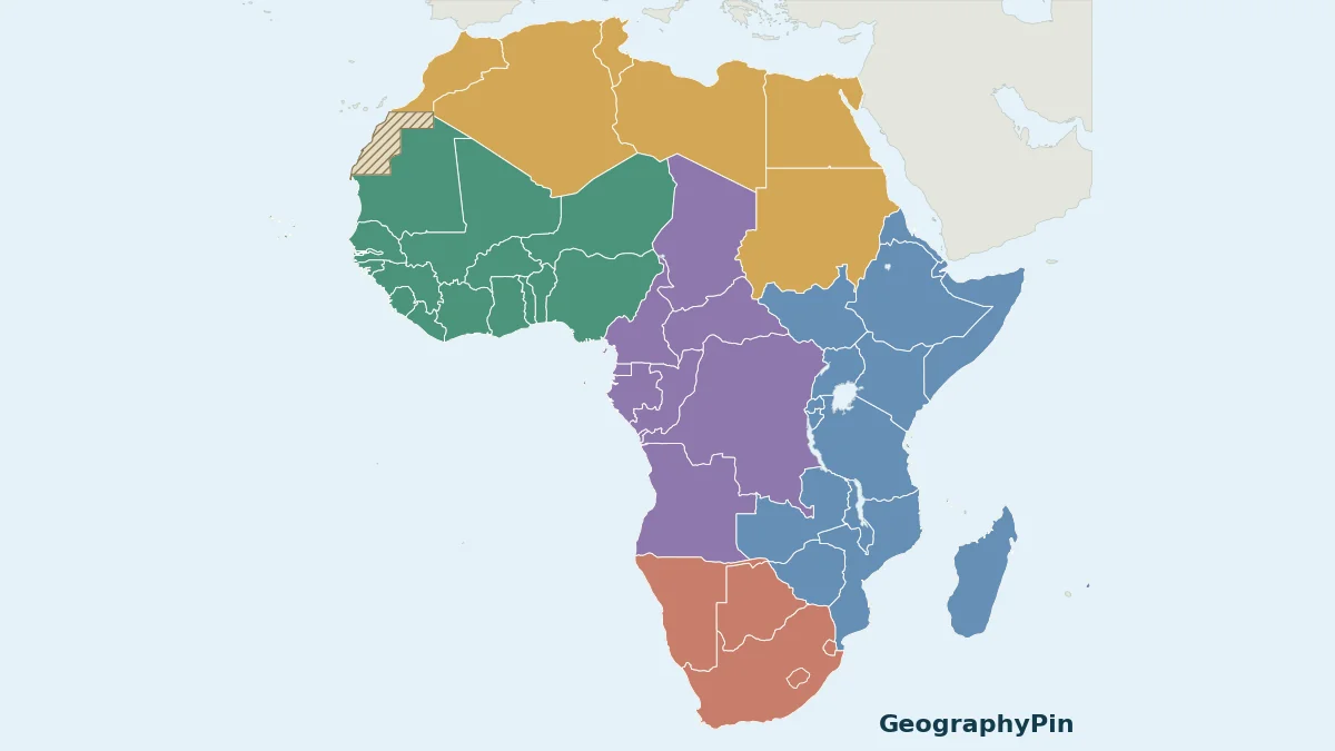
A single Africa map can become unreadable when every small country and island is squeezed into one image. This atlas uses a continent overview for orientation and five separate regional sheets for country identification. The country names correspond to the numbered map key.
This Africa map resource covers the continent’s 54 United Nations member states. Five readable sheets locate the countries under UN M49 regional groupings, including offshore island states. Western Sahara is hatched separately and is not counted as a 55th state. The blank PDF and labeled atlas use the same declared scope.
How to use this resource: Check the counting rule, read the boundary notes, or print a practice map.
1. Start With the Regional Overview
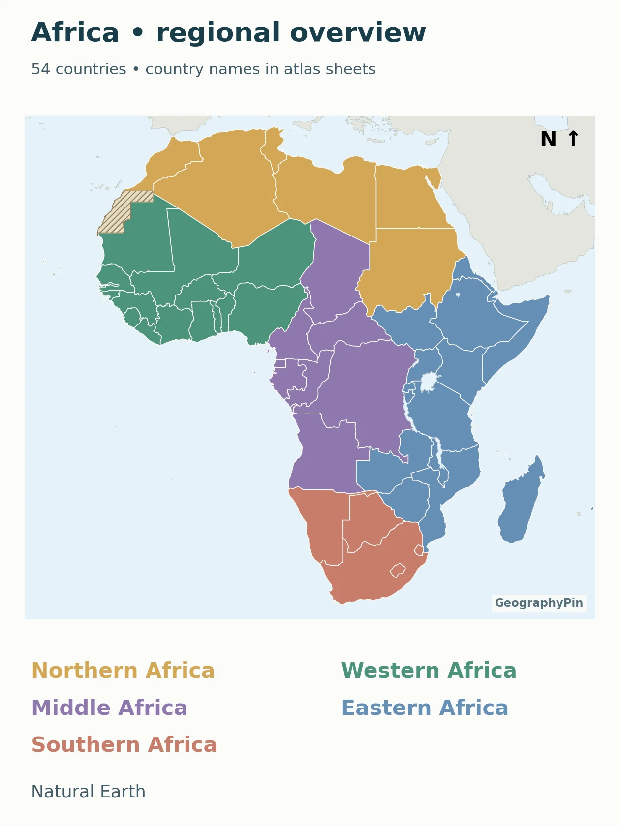
The overview colors tell you which regional sheet to open. They do not indicate population, elevation, wealth, language or alliance membership. Country names are deliberately moved to the larger regional sheets rather than made too small to read.
The atlas is organized around map identification. For capitals and their exceptional administrative roles, use the established Africa countries and capitals reference.
2. Open the Readable Country Sheets
Open the regional sheet you need. Each sheet has its own numbered country key directly under the map; numbering restarts on each sheet. The numbers locate countries, not capitals, and are not rankings.
Northern Africa: 6 country locators
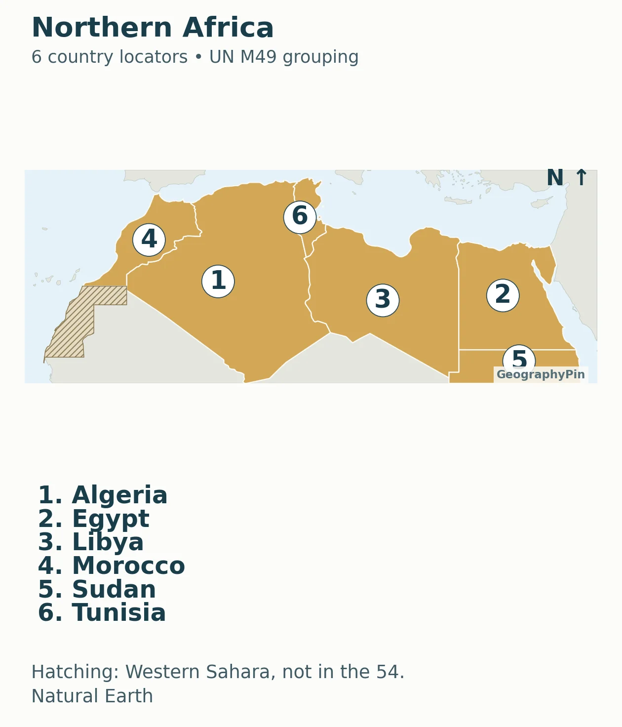
Download this regional sheet as PDF.
Accessible map key: 1. Algeria; 2. Egypt; 3. Libya; 4. Morocco; 5. Sudan; 6. Tunisia.
Western Africa: 16 country locators
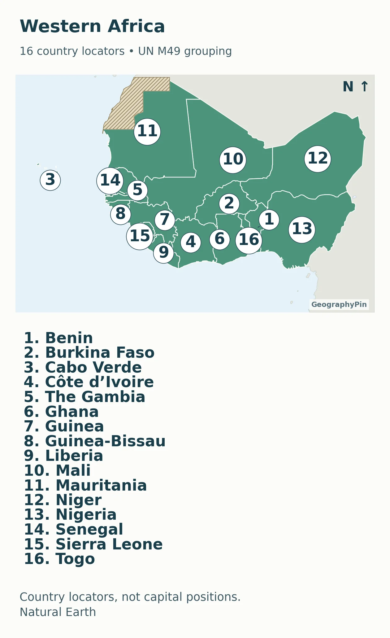
Download this regional sheet as PDF.
Accessible map key: 1. Benin; 2. Burkina Faso; 3. Cabo Verde; 4. Côte d’Ivoire; 5. The Gambia; 6. Ghana; 7. Guinea; 8. Guinea-Bissau; 9. Liberia; 10. Mali; 11. Mauritania; 12. Niger; 13. Nigeria; 14. Senegal; 15. Sierra Leone; 16. Togo.
Middle Africa: 9 country locators
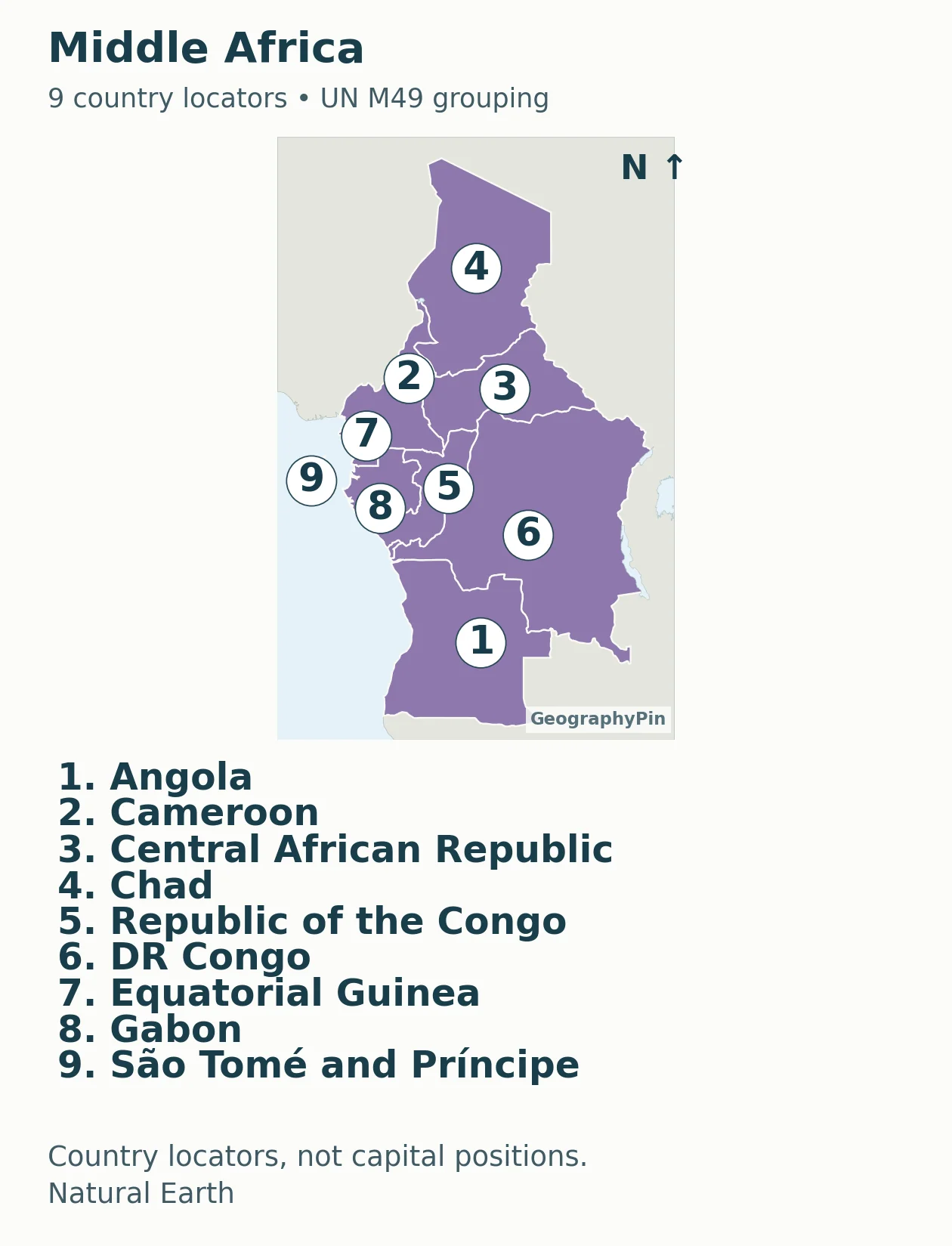
Download this regional sheet as PDF.
Accessible map key: 1. Angola; 2. Cameroon; 3. Central African Republic; 4. Chad; 5. Republic of the Congo; 6. DR Congo; 7. Equatorial Guinea; 8. Gabon; 9. São Tomé and Príncipe.
Eastern Africa: 18 country locators
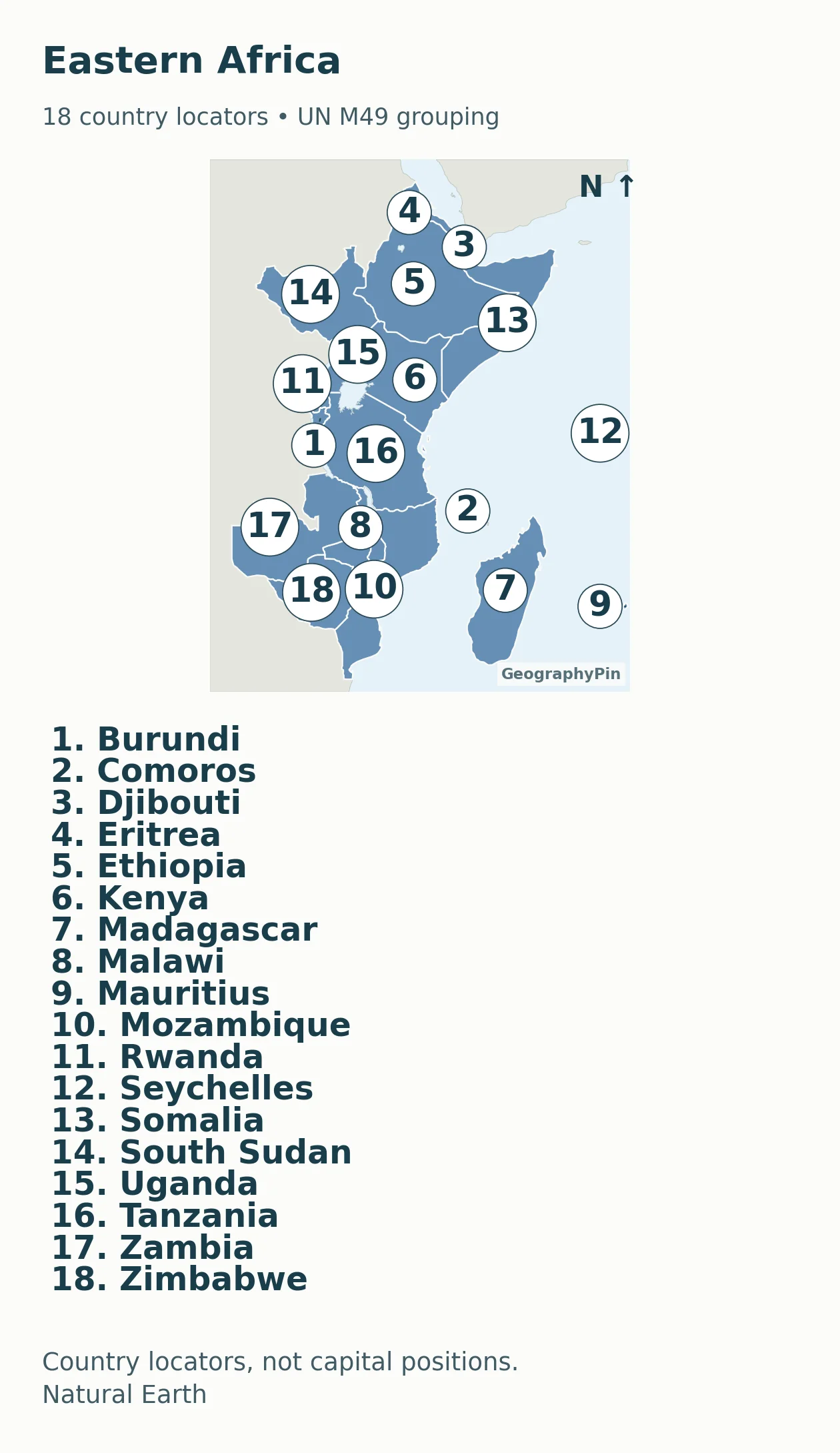
Download this regional sheet as PDF.
Accessible map key: 1. Burundi; 2. Comoros; 3. Djibouti; 4. Eritrea; 5. Ethiopia; 6. Kenya; 7. Madagascar; 8. Malawi; 9. Mauritius; 10. Mozambique; 11. Rwanda; 12. Seychelles; 13. Somalia; 14. South Sudan; 15. Uganda; 16. Tanzania; 17. Zambia; 18. Zimbabwe.
Southern Africa: 5 country locators
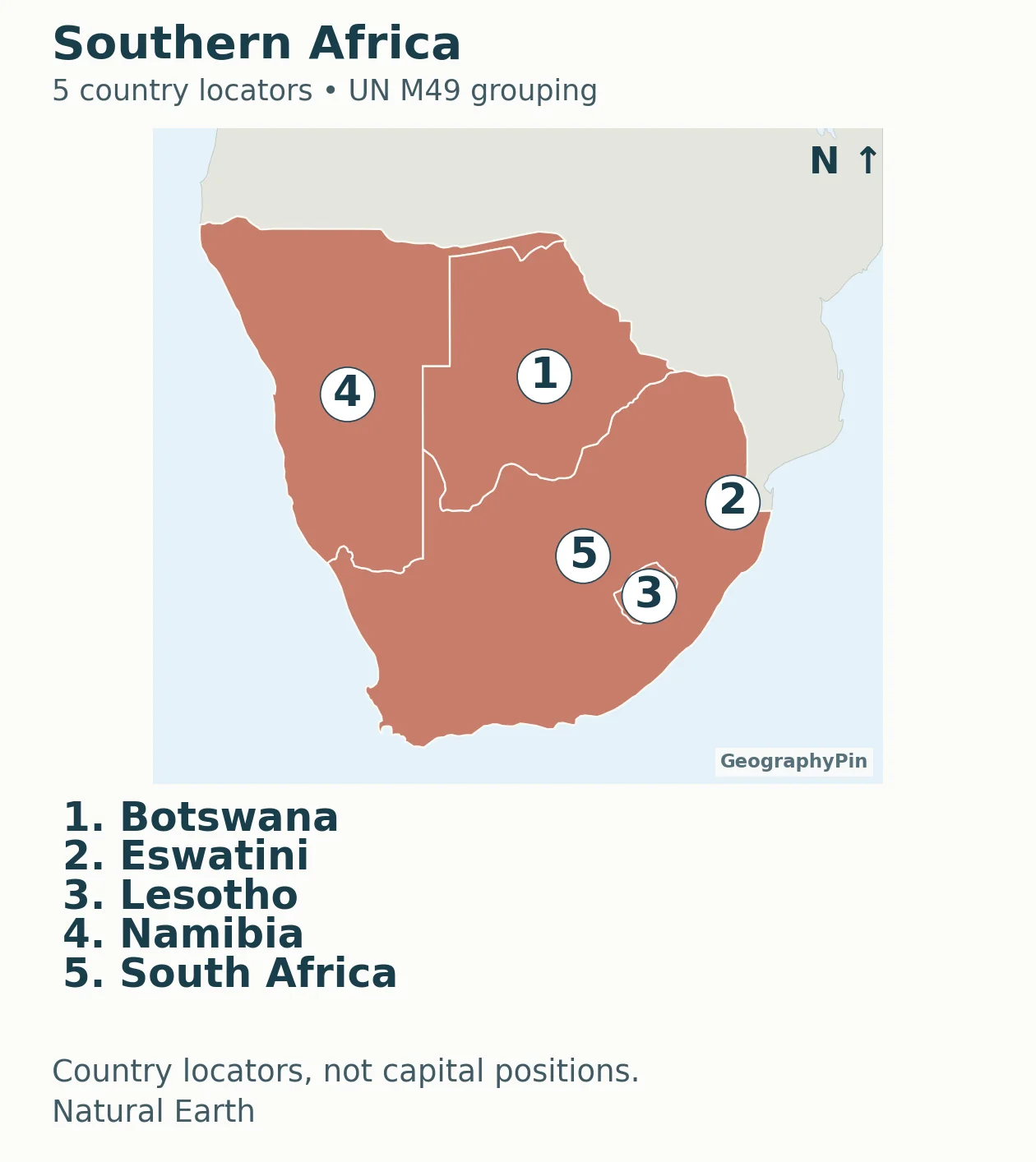
Download this regional sheet as PDF.
Accessible map key: 1. Botswana; 2. Eswatini; 3. Lesotho; 4. Namibia; 5. South Africa.
A local number can refer to different countries on different sheets. Always keep the sheet name with the number when using the maps as an exercise. The accompanying downloadable key preserves that pairing, together with the country name, ISO code and M49 reference.
3. Understand the Counting and Boundary Rules
Fifty-four states, not every map polygon
The count is the 54 African UN member states. M49 is used to place those states into Northern, Western, Middle, Eastern and Southern Africa; its full database also contains countries or areas that are not sovereign states. A statistical area, territory and independent country are not interchangeable units.
The sheets contain six states in Northern Africa, sixteen in Western Africa, nine in Middle Africa, eighteen in Eastern Africa and five in Southern Africa. These sum to 54. They are M49 groupings, not a claim that every school atlas, regional organization or research project must draw its regions the same way.
Western Sahara and other boundary limits
Western Sahara is shown with hatching and excluded from the 54-state total. The United Nations lists it as a Non-Self-Governing Territory. The hatching is not a declaration that its final status has been settled, and it is not a current line-of-control map.
Natural Earth’s default de facto Morocco geometry overlaps part of Western Sahara. The source-defined Western Sahara polygon was removed from that country fill and shown separately, rather than quietly presenting it as undisputed Moroccan territory. Somalia’s locator includes the source polygons for Somalia and Somaliland, without counting Somaliland as a separate country in this UN-member-state convention.
Small offshore states are included rather than dropped for convenience: Cabo Verde appears in the western sheet, São Tomé and Príncipe in the middle sheet, and Comoros, Madagascar, Mauritius and Seychelles in the eastern sheet. Locator symbols make the smaller islands findable without claiming that the symbol’s diameter is their land area.
4. Print the Blank Map and Practice
Labeled atlas, blank map and map-key file
Download the complete labeled regional atlas (PDF) · Download the blank continent map (PDF) · Download the country key (PDF).
For a first exercise, use the blank overview to identify the broad regional position of a country. Then open its labeled sheet to check the answer. For very small countries or islands, use a leader line or numbered dot rather than trying to write the entire name inside a tiny outline. Explain that the symbol marks location and is not drawn to the country’s physical size.
The country locators are not capital-city coordinates. For capitals, use the linked country-and-capital reference. Placing a capital at a country-number marker would turn a useful map key into false geographic information.
Print with “fit to page” if needed. The vector PDF remains clear when enlarged, but enlarging it does not add geographic detail beyond the generalized source. These maps are for regional learning, not border surveying or long-distance measurement. The numbered sheets use a north-up regional display; a single uniform distance scale is not asserted for the whole atlas.
What Did We Learn Today?
Use the continent map to choose a regional sheet, then match the local numbers to the adjacent key. This keeps all 54 states in the resource without shrinking country names into unreadable labels. Western Sahara’s separate hatching and the inclusion of offshore states preserve the counting rule rather than hiding awkward map cases.
Sources & Data Notes
Country grouping follows the stated UN M49 convention. The map-key downloadable key records the selected entries, not a new sovereign-recognition list. Natural Earth version 5.1.1 provides generalized country and disputed-area geometry under public-domain terms. Explicit source-based geometry adjustments are documented in the accompanying methodology note. No live control, population or distance-measurement dataset is implied.