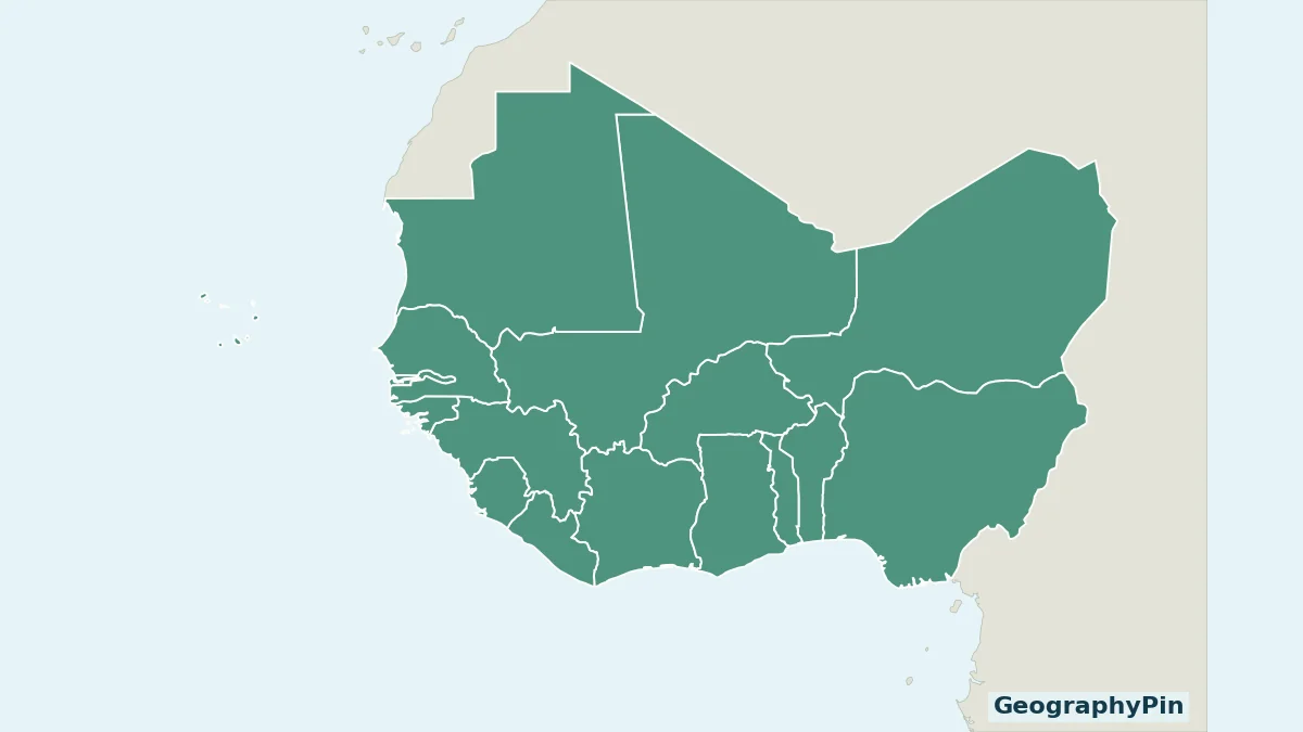
West Africa contains both a long Atlantic coastline and countries far inland. A useful regional map must also show Cabo Verde rather than treating the mainland as the entire region. This one makes its counting rule explicit and keeps the country key beside the geography.
West Africa has sixteen sovereign countries under the UN M49 Western Africa grouping: Benin, Burkina Faso, Cabo Verde, Côte d’Ivoire, The Gambia, Ghana, Guinea, Guinea-Bissau, Liberia, Mali, Mauritania, Niger, Nigeria, Senegal, Sierra Leone and Togo. M49 also lists Saint Helena as an area, but it is not a seventeenth sovereign country.
How to use this article: check the counting rule, avoid common capital mix-ups, open printable maps.
1. West Africa Map and the Sixteen-Country List
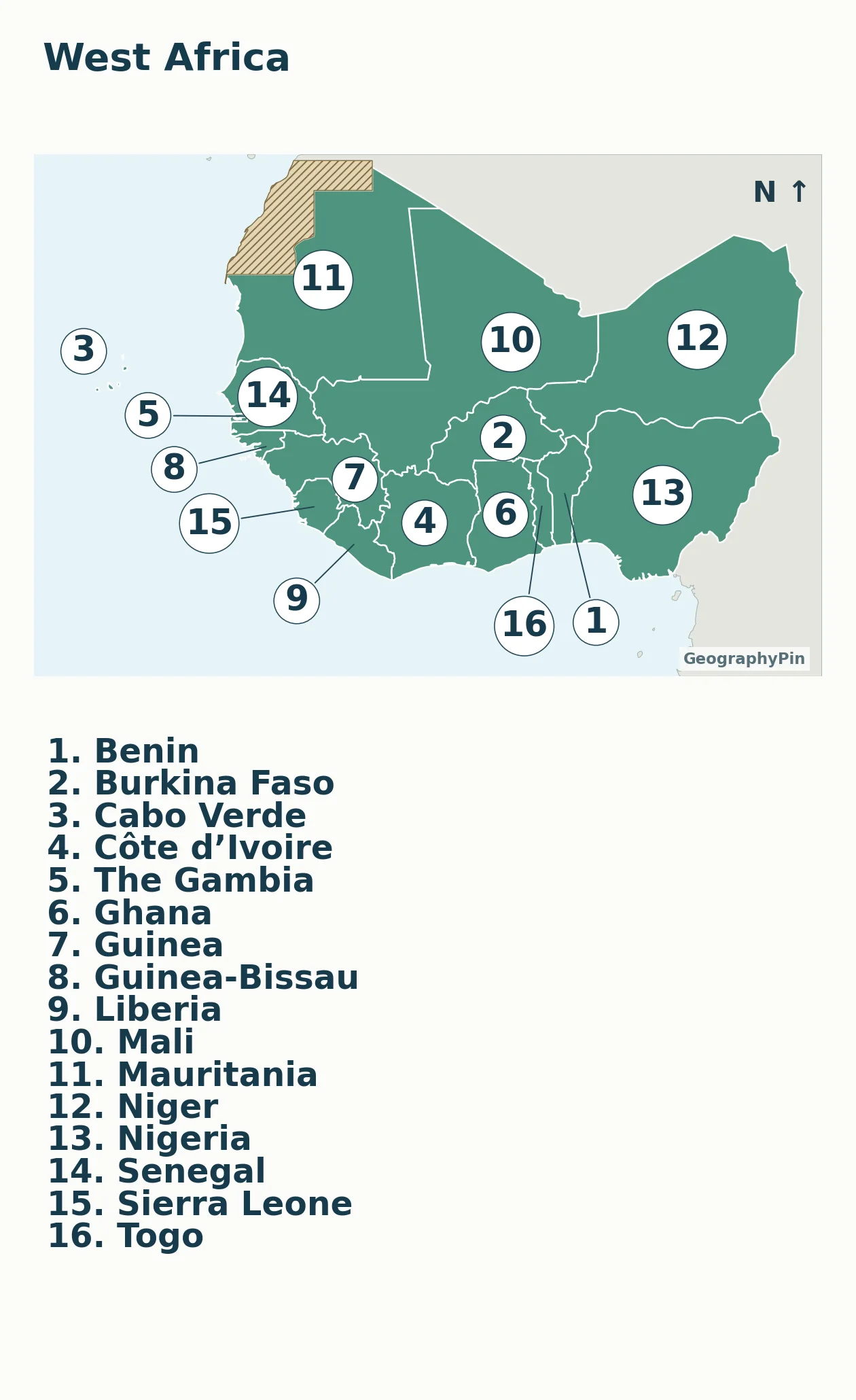
Match each map number to the table directly below. Leader lines keep the narrow coastal countries legible without stretching their borders. The numbers indicate countries, not capital-city locations.
| Map no. | Country | Capital |
|---|---|---|
| 1 | Benin | Porto-Novo |
| 2 | Burkina Faso | Ouagadougou |
| 3 | Cabo Verde | Praia |
| 4 | Côte d’Ivoire | Yamoussoukro |
| 5 | The Gambia | Banjul |
| 6 | Ghana | Accra |
| 7 | Guinea | Conakry |
| 8 | Guinea-Bissau | Bissau |
| 9 | Liberia | Monrovia |
| 10 | Mali | Bamako |
| 11 | Mauritania | Nouakchott |
| 12 | Niger | Niamey |
| 13 | Nigeria | Abuja |
| 14 | Senegal | Dakar |
| 15 | Sierra Leone | Freetown |
| 16 | Togo | Lomé |
Capital names that are easy to mix up
Porto-Novo is Benin’s constitutional capital; Cotonou is the major economic center identified separately in the UNdata profile. Côte d’Ivoire’s listed capital is Yamoussoukro, not Abidjan. UNdata distinguishes Abidjan’s administrative role in a footnote. These are reasons to retain a capital note, not to count two countries or silently replace the named capital.
Guinea and Guinea-Bissau are separate countries with different capitals: Conakry and Bissau. Niger and Nigeria are also distinct, with Niamey and Abuja respectively. The Gambia is sorted under G in the alphabetical map key. Cabo Verde is the name used in the UN classification, rather than the older English form Cape Verde.
For the full continental list and more capital-role explanations, use 54 countries in Africa and their capitals. That broader table is not a different definition of West Africa.
2. Why the Count Is Sixteen, Not Seventeen
Countries and areas are different units
The M49 table is headed “countries or areas.” Counting all of its Western Africa entries therefore answers a different question from counting sovereign states. Sixteen entries are countries; Saint Helena is the additional area entry. The United Kingdom identifies St Helena, Ascension and Tristan da Cunha as a British overseas territory.
This map highlights only the sixteen sovereign countries. It does not place Saint Helena at a made-up mainland location or add it as a seventeenth country. Cabo Verde, by contrast, is a sovereign island country and belongs in the country count even though it is separated from the mainland by the Atlantic.
Mauritania is included in M49 Western Africa. Western Sahara is listed in M49 Northern Africa, while Cameroon and Chad are placed in Middle Africa. A different regional study may use a wider West African study area, but it should say so. The M49 assignment is a statistical convention, not a declaration that all other geographic uses are invalid.
3. Read the Coast, Interior and Island Geography
The northern mainland members include Mauritania, Mali and Niger. Burkina Faso is farther south in the interior. Mali, Burkina Faso and Niger are landlocked; Mauritania reaches the Atlantic. Confusing “northern part of West Africa” with the separate UN region “Northern Africa” changes the question.
Along the Atlantic side, Senegal surrounds The Gambia on its landward sides, while The Gambia also opens onto the ocean. Guinea-Bissau, Guinea, Sierra Leone and Liberia continue the coastal sequence southward and southeastward. The coast then runs toward Côte d’Ivoire, Ghana, Togo, Benin and Nigeria. Cabo Verde sits offshore to the west of the mainland, not in an inset moved beside Nigeria.
The Niger links landscapes across borders
A country map does not show every physical connection. The Niger River’s inland delta in Mali is one example: USGS describes a seasonal network of lakes, channels and marshes supplied by water arriving from the river’s headwaters in the Guinea Highlands. It is an inland wetland, not the river’s coastal mouth.
That example helps explain why neither a single color nor a national boundary describes the whole landscape. A statistical region can contain dry interiors, coastal areas, highlands and seasonal wetlands. The supplied map shows country membership only, not rainfall zones, vegetation classes or precise river courses.
4. West Africa Is Not the Same as ECOWAS
ECOWAS, the Economic Community of West African States, is an intergovernmental organization. Western Africa in M49 is a statistical geographic grouping. Membership in the organization can change without moving a country to a different part of the continent.
For a concrete example, ECOWAS announced that the withdrawal of Burkina Faso, Mali and Niger took effect on January 29, 2025. All three remain in the M49 Western Africa list used for this map. Their withdrawal therefore does not reduce this geographic count from sixteen to thirteen.
This is deliberately not a current ECOWAS membership or border-access map. For an institutional membership list, consult ECOWAS itself; for travel permissions or border conditions, use the relevant current authorities. A country’s geographic coloring cannot answer those administrative questions.
5. Download and Use the Maps
Printable maps and the source table
Download the labeled map PDF · Download the blank practice map PDF · Download the country and capital key (PDF).
The blank PDF removes numbers and country names while keeping the same outline and regional scope. Use the labeled map as an answer key. On a phone, the complete map fits the article width. Use the zoom controls for a closer look and match its numbers to the country table directly below.
For a classroom exercise, identify the three landlocked members, locate Cabo Verde, and distinguish Guinea from Guinea-Bissau and Niger from Nigeria. Then add the capitals from the table. Do not place capital cities at the country-number markers: those markers were chosen for readable country identification, not as city coordinates.
Natural Earth’s 1:50 million outlines are generalized. Tiny islands and detailed border features may not be visible at this display size. Neighboring land is deliberately unclassified gray, so the image does not take a position on every neighboring territorial dispute or pretend to provide a detailed boundary survey.
What Did We Learn Today?
The sixteen-country count follows a stated statistical rule: include the sovereign states in M49 Western Africa, include offshore Cabo Verde, and exclude the Saint Helena area from the sovereign-country total. The map then becomes easier to read through the contrast between coast, interior and islands. ECOWAS membership remains a separate question.
Sources & Data Notes
Membership follows the M49 Western Africa list with Saint Helena excluded from the sovereign-state count. All sixteen capital pairs were checked against individual UNdata 2025 profiles; the downloadable PDF key contains those links. The ECOWAS example records its dated 2025 withdrawal announcement, not a claim that organizational or travel rules never change. Map geometry is Natural Earth public-domain data, not measured environmental-zone boundaries.