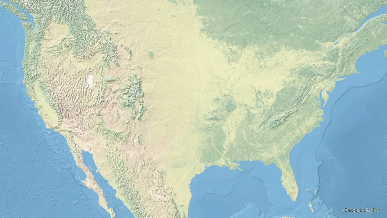
Follow terrain and water rather than state lines. The shaded-relief map shows selected mountain systems, plains, rivers and lakes, with separate views for Alaska and Hawaii.
A physical map of the USA shows landforms and water features rather than primarily organizing the country by states. Major patterns include western mountain systems, the Great Plains and interior lowlands, the eastern Appalachians, and large connected river systems. Alaska and Hawaii require separate views because their locations and terrain differ from the contiguous states.
How to use this article: read the relief map, interpret the main features, use the key and scale.
Maps fit the screen by default. Select 2× or 4× for details, swipe or scroll within the map, and choose Fit / Reset for the full view.
1. US Relief Map and Printable Download
Read the relief map
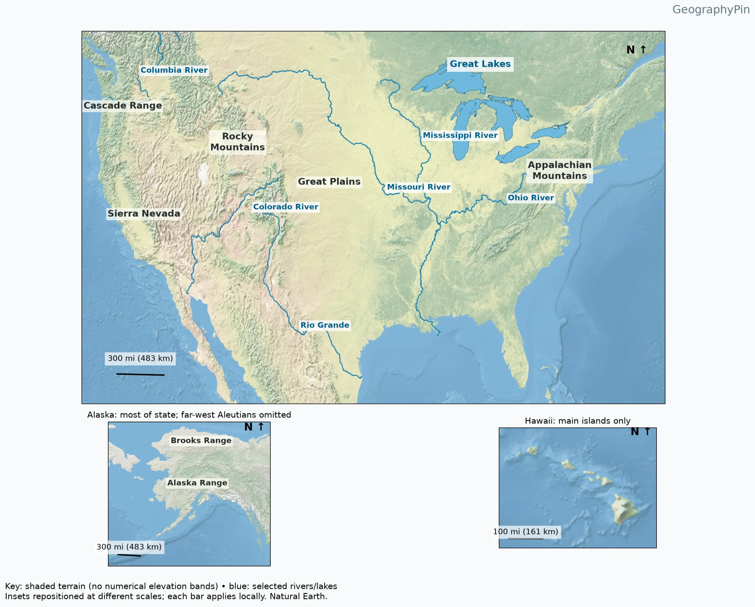
The shaded texture gives the map its physical-geography purpose. Western mountain belts stand out from broader plains, while blue overlays identify selected rivers and the Great Lakes. The labels are teaching landmarks, not a claim that unlabelled terrain lacks a name or that the displayed rivers are the only important ones.
Open the PDF to enlarge or print the map. The image and PDF use the same dataset and selection, so there is no second, conflicting answer key. The coastline and relief extend beyond the United States for context; surrounding Canadian and Mexican terrain does not become US territory because it appears inside the frame.
2. Physical Versus Political Maps
| Question | Best map emphasis |
|---|---|
| Where are the Rocky Mountains? | Physical relief and landform labels |
| Which state contains a city? | Political boundaries and city locations |
| Which rivers connect? | Hydrography and drainage information |
| How high is a particular summit? | A verified elevation dataset or topographic map |
A physical map can include boundaries, and a political map can include mountains, but their emphasis differs. The broader field of physical geography studies the natural features and processes behind these patterns. Coloring the 50 states alone does not make a physical map. Conversely, a relief image without a clear legend should not be treated as a precise elevation measurement.
Relief means the differences in terrain height and shape. Elevation is height relative to a specified reference level. A broad high plain can have considerable elevation without the steep local relief of a mountain valley. The terms are related, not interchangeable.
3. Mountain Ranges, Plains and Interior Terrain
Interpret the main features
The Rocky Mountains form part of the western mountain system. Farther toward the Pacific, the Sierra Nevada and Cascade Range are distinct named ranges rather than alternate names for the Rockies. USGS and National Park Service physiographic references separate these systems and the intervening basins and plateaus.
The Great Plains lie east of the Rockies. On this map their broad smoother surface contrasts with the adjacent mountain texture. The Appalachians form a different mountain belt in the eastern United States. Neither the Great Plains nor the Appalachians has a single simple boundary that can be inferred from the position of a text label.
Read the spaces between labels as well as the names. Valleys, plateaus, basins and lowlands explain why the western United States is not one continuous ridge and why the interior is not one perfectly level surface. The map intentionally avoids drawing invented sharp outlines around these broad features.
4. Major Rivers and the Great Lakes
The Mississippi, Missouri and Ohio belong to a connected drainage system. Following the drawn channels helps distinguish tributaries from separate outlets. The map highlights these rivers rather than coloring the entire Mississippi drainage basin, so land next to a blue line should not be interpreted as the only land contributing runoff.
The Columbia, Colorado and Rio Grande illustrate other major river pathways in the west and southwest. Their routes cross political boundaries and respond to terrain. The Colorado River shown here is the western river, not the separate river with the same name in Texas.
The five Great Lakes are Superior, Michigan, Huron, Erie and Ontario. Their grouping is shown as water, not as a separate political region. Blue lake area and blue river lines use different geometry: a lake polygon represents an area, while a centerline simplifies a channel too narrow to draw to scale at this map size.
5. Alaska and Hawaii Are Not Mainland Appendages
Alaska’s inset includes the Brooks Range and Alaska Range, showing why the state cannot be represented by a flat outline alone. Its mountains, valleys, glaciers and coastal terrain belong to a different physical setting from the main map. The inset is moved into the page layout; it does not depict Alaska beside the southwestern United States.
Hawaii’s islands are volcanic landforms rising from the Pacific. The inset shows the main islands, not the full island chain or the entirety of the submerged volcanic system. National Park Service geology material explains that the visible islands are only the exposed portions of much larger volcanic mountains.
Do not compare island sizes or distances across the insets by eye. Each view has its own local scale bar. The far-west Aleutians and Hawaii’s outlying islands are omitted at this teaching-map scale, and the captions disclose those limits.
6. How to Read the Key Without Overinterpreting It
Use the key and scale
Shading depicts terrain form; blue overlays identify the selected rivers and lakes. The raster does not supply a numeric elevation value for every color, so this map deliberately has no invented elevation bands. Use a digital elevation model or contour map when a question requires a specific height, slope or summit measurement.
The local bars show 300 miles (483 kilometers), except the Hawaii inset’s 100 miles (161 kilometers). North arrows identify orientation. Because scale changes across these broad views, a bar should not be moved to another part of the page to measure an exact distance. This is an educational regional reference, not a route-planning or surveying tool.
Frequently Asked Questions
Does the printable map include Alaska and Hawaii?
Yes, in separate insets. They are repositioned and use independent local scales. The far-west Aleutians and Hawaii’s outlying islands are omitted, as stated beneath the map.
What Did We Learn Today?
A physical map explains terrain and connected water features rather than replacing a political map. Western and eastern mountain systems, broad plains, major river routes and the Great Lakes provide the main reference pattern here. Alaska and Hawaii need separate scales, and relief shading should not be mistaken for a numeric elevation dataset.
Sources & Data Notes
The maps combine Natural Earth shaded relief with actual river centerlines, lake polygons and geographic-region label anchors. Region polygons are used only to locate labels; their edges are not presented as exact mountain or plain boundaries. This is a selected-feature reference, not an exhaustive inventory. Terrain colors are illustrative and do not encode numerical elevation intervals. Distance bars are geodesically calculated on WGS84 and apply locally; scale varies elsewhere in these latitude–longitude views.