River mouths are often taught as a choice between a delta and an estuary. That shortcut hides an important distinction: one term describes a sediment-built landform, while the other describes a water environment that can occupy part of the same coast.
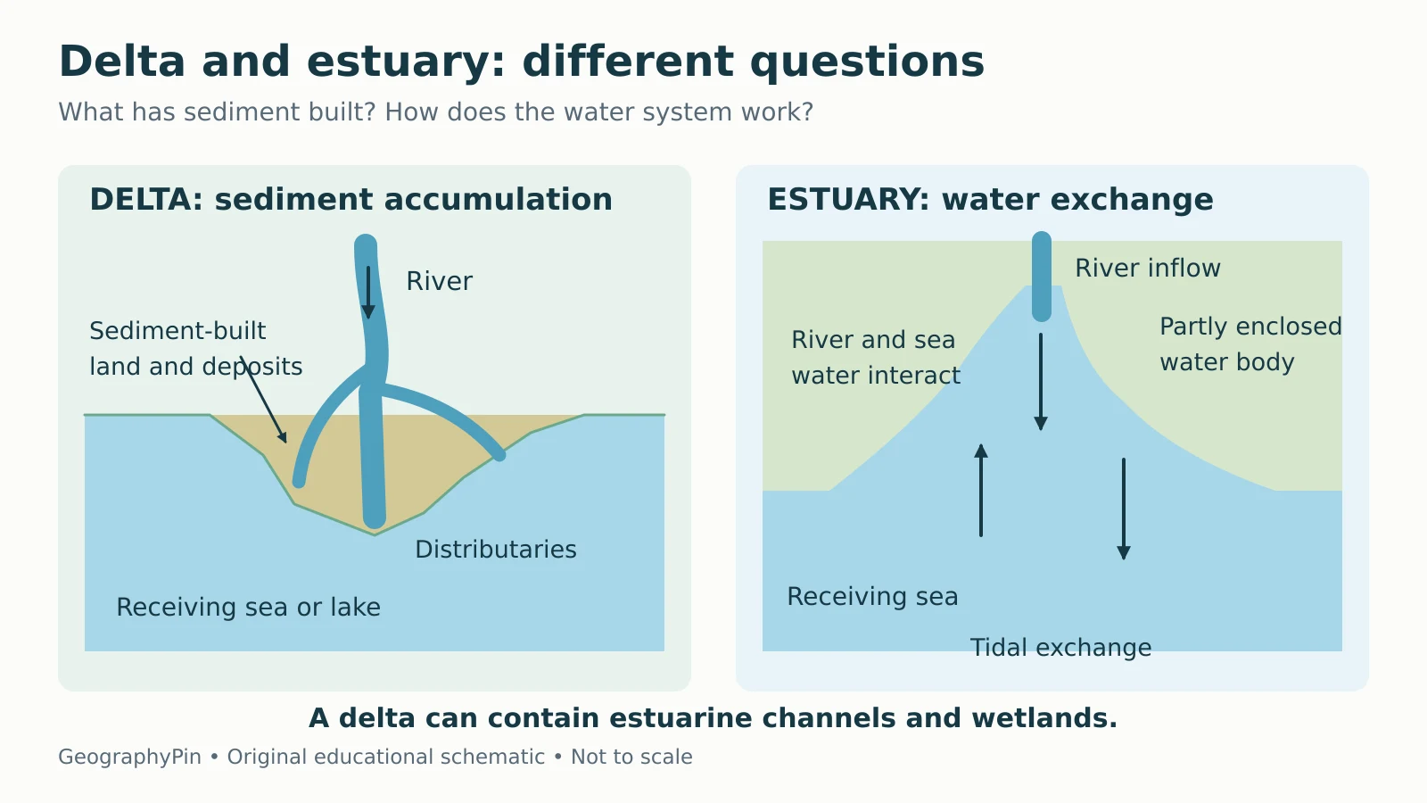
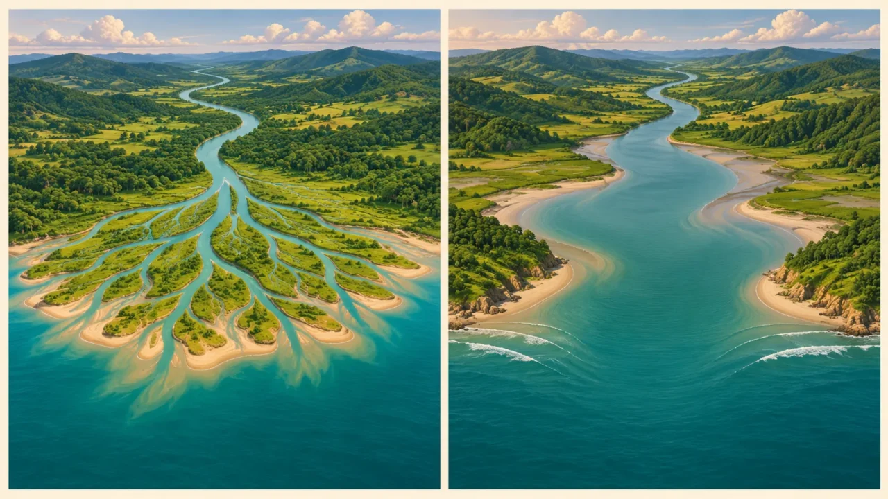
A delta is a landform built by sediment deposited at a river mouth, while an estuary is a partly enclosed water system where river water interacts with a sea or, in freshwater examples, a large lake. The categories can overlap: a delta may contain estuarine channels and wetlands, so one river mouth can fit both descriptions.
How to use this article: You can compare the two definitions, see how they overlap, or check six examples.
Delta and Estuary Compared
Ask two different questions
To identify a delta, ask what sediment has built. To identify an estuary, ask how the river, the receiving water and the basin interact. A triangular outline or a wide river mouth can offer clues, but neither shape proves the classification on its own.
| Feature | Delta | Estuary |
|---|---|---|
| Main focus | Sediment deposit and associated landform | Water body, circulation and ecosystem |
| Defining process | River sediment accumulates at the mouth | River inflow interacts with receiving water |
| Typical features | Depositional plain, channels, mouth bars | Partly enclosed basin, channel or coastal wetland |
| Salinity | May include fresh, brackish or salt-influenced areas | Often brackish on ocean coasts; freshwater examples exist |
| Relationship to waves and tides | They reshape and redistribute deposits | They help exchange and mix water |
| Can the two coexist? | Yes, within a delta system | Yes, including estuarine parts of deltas |

How a Delta Forms
A river transports sediment eroded from its drainage basin. When flow spreads into a lake or sea, some of that sediment settles. A delta develops where accumulation at the mouth builds a deposit rather than having all the incoming material removed or carried farther away.
The balance is more useful than the oversimplified rule that “slow water makes a delta.” River discharge, grain size, waves, tides and space available for sediment all matter. The USGS discussion of rivers and delta sediment budgets emphasizes sediment supply relative to redistribution by marine processes.
Many deltas split into distributaries, channels that branch away from the main river. Tributaries do the reverse: they join a larger stream. Mouth bars can redirect flow, channels can shift, and different parts of a delta can build or lose land at the same time.
The Greek letter delta supplied the familiar triangular image, but real deltas need not be neat triangles. River flow, coastal currents and waves can produce lobes, elongated channels or smoother shorelines. For the upstream processes that supply the material, see water erosion and river landforms.
How an Estuary Forms and Circulates
Many coastal estuaries occupy valleys flooded by rising sea level. Others lie behind barrier islands, in tectonic basins or within glacially carved fjords. Their common feature is the interaction between inflowing water, the basin and its connection to the receiving water, rather than one universal shape.
In a marine estuary, river water is generally less salty and less dense than seawater. It can flow above denser saltwater, or the two can mix more thoroughly. Tidal energy, river flow, wind and basin geometry affect the result. Salinity therefore varies through the estuary and can change with depth, season and weather.
NOAA’s estuary circulation tutorial describes patterns from strongly layered salt wedges to more thoroughly mixed systems. “Brackish” means that fresh and salty water combine; it does not mean every sample in the estuary has the same salt content.
A fjord can therefore be both a glacial landform and an estuary. A bay name alone is less informative. GeographyPin’s gulf, bay and fjord comparison separates those coastal terms from the processes operating inside them.
Can a River Mouth Be Both?
A delta can contain an estuary
Yes. Delta channels, bays and wetlands can contain the freshwater–seawater interaction that makes them estuarine. NOAA’s National Estuarine Research Reserve System explicitly includes a delta-system category and gives the Mississippi and Nile river mouths as examples.
This is why a diagram showing “delta or estuary” can be misleading if it implies that sediment deposition excludes mixing. Estuaries can also trap substantial sediment. The distinction is about what is being described, not a rule that one place must have only one label.
Scale matters as well. “The delta” may refer to an extensive depositional plain and its submerged deposits, while an estuary name may refer to one bay or a connected water system within or beside it. Read the mapped extent and the author’s definition before comparing areas or counting examples.
Six Examples That Clarify the Difference
Read the labels as explanations, not opposing boxes
The examples below illustrate several processes. They are not a ranking, an exhaustive list or a claim that each place has only one accepted classification.
| Place | Useful classification | What it demonstrates |
|---|---|---|
| Mississippi River mouth, United States | Delta with estuarine environments | Deposition and freshwater–saltwater interaction coexist |
| Nile River mouth, Egypt | Delta system | A delta can also contain estuarine environments |
| Chesapeake Bay, United States | Drowned river-valley estuary | A flooded valley provides the basin |
| San Francisco Bay, United States | Tectonically influenced estuary | Basin structure affects the water system |
| Kachemak Bay, Alaska | Fjord-type estuary in NOAA’s classification | Glacially shaped coastal relief can host an estuary |
| Old Woman Creek, Lake Erie | Freshwater estuary | River–lake mixing does not require seawater |
These examples follow NOAA’s estuary overview and its Old Woman Creek reserve profile. Other classification schemes group estuary origins differently, so the number of named estuary “types” is not a universal fixed total.
Why a freshwater estuary is not a contradiction
Along the Great Lakes, river water can differ chemically and physically from lake water even though both are fresh. Coastal wetlands and water exchange create estuary-like systems. NOAA uses the term freshwater estuary for these environments and notes the importance of storm-driven water movement and seiches, the sloshing of lake water.
This is a broader ecological usage than the traditional brackish-water definition. State which usage applies rather than insisting that all estuaries must contain salt. The related question of how water moves through inland basins is covered in what makes a lake a lake.
What the Labels Tell You, and What They Do Not
A satellite image is useful for recognizing branching channels, depositional lobes and enclosed coastal water. It cannot, by itself, establish salinity, prove a sediment budget or show how circulation changes over a year. Those questions require observations and a stated time period.
Similarly, a delta is not guaranteed to be growing. Reduced sediment delivery, channel engineering, subsidence and rising relative sea level can shift the balance toward land loss. An estuary is not guaranteed to be clean or well mixed. Restricted exchange and excessive nutrient or sediment inputs can create environmental stress.
For a quick classification, use this sequence:
- Identify the river mouth and receiving water.
- Look for a sediment-built deposit, not just a triangular shape.
- Check whether the water system is partly enclosed and how river and receiving waters interact.
- Allow both labels when the evidence supports both.
- Keep landform, circulation and ecosystem descriptions separate.
The result is more reliable than matching a coastline to a single classroom silhouette.
What Did We Learn Today?
Deltas and estuaries answer different geographic questions. Sediment accumulation identifies a delta; water interaction and the basin setting identify an estuary. Their overlap explains why a branching river mouth can also support brackish wetlands, why a fjord may be an estuary, and why freshwater Great Lakes examples need a clearly stated definition.
Sources & Data Notes
This comparison uses delta as a depositional landform and estuary as a water-system and ecological term. NOAA sources use more than one classification scheme; the freshwater usage is identified separately. Examples illustrate processes rather than exclusive categories. The original diagram is schematic and has no geographic scale.