Lake Ontario is the easternmost and smallest Great Lake by surface area, shared by Ontario, Canada, and New York, United States. Its maximum depth is 802 ft (244 m). “Lake America” became the U.S. federal name on August 27, 2026, while Canada retained “Lake Ontario” as its official English geographic name.
Naming status last verified: August 28, 2026.
How to use this article: Start with the lake’s location between Ontario, Canada, and New York, United States; use depth and basin shape for its 802 ft (244 m) maximum; check the naming-status table to see why Lake America is official for U.S. federal use but not for Canada; and follow the Great Lakes water route from the Niagara River to the St. Lawrence River.
Which Name Is Official?
There is no single answer without naming the authority. The U.S. federal government now uses Lake America. Canada’s English-language geographic-name record remains Lake Ontario, with Lac Ontario as the official French form. GeographyPin uses Lake Ontario for the general profile because it remains Canada’s official English geographic name and the longstanding name in international and common usage.
The current naming status by authority
| Context | Name currently used | Status |
|---|---|---|
| U.S. federal government | Lake America | Implemented through the August 27 presidential order, Interior Secretarial Order 3453 and the GNIS official-name field on August 27, 2026 |
| Government of Canada and Ontario | Lake Ontario | Remains the official Canadian English geographic name; Lac Ontario is the official French form |
| New York State | Lake Ontario | Governor Kathy Hochul stated that New York would not adopt the new federal usage; this is the state government’s stated position |
| International organizations and private maps | Varies | The U.S. order does not compel adoption outside the federal government |
What changed on August 27, 2026
President Donald Trump signed an executive order titled “Honoring the American History of the Great Lakes and Renaming Lake Ontario as Lake America”. It directed the Interior Secretary and U.S. Board on Geographic Names to adopt Lake America for the body of water and standardize that name across federal maps, contracts, documents and communications.
Interior Secretary Doug Burgum issued Secretarial Order 3453 the same day. It ordered immediate implementation, and the Geographic Names Information System record changed its official-name field to Lake America with a federal decision date of August 27. Lake Ontario remained visible as a variant when the record was checked, while federal basemaps were still being updated.
The order came amid a wider U.S.–Canada trade dispute. That context explains the timing reported by Reuters, but the geographic effect of the action is much narrower than the political dispute: it standardizes U.S. federal nomenclature.
The administration presented the change as recognition of American history, commerce, defense, Great Lakes investment and the lake’s economic value. It also claimed that the United States contains most of the lake’s water volume because the deepest areas lie south of the international boundary. Those are the administration’s stated reasons and claims, not a new international geographic settlement.
What the order did not change
- It did not move or alter the Canada–United States boundary.
- It did not rename the lake in Canada’s geographic-name system.
- It did not require New York State, private businesses, international organizations or independent mapmakers to use Lake America.
- It did not create two physical lakes or rename only the American side.
- It did not amend water rights, navigation rights, environmental agreements or binational management arrangements.
- It did not give one country jurisdiction over the other country’s side of the boundary.
The U.S. federal name applies to the entire lake as one feature in federal nomenclature. Canada’s official naming system likewise applies Lake Ontario to the entire feature. The disagreement is between naming authorities, not a new line dividing the water into a northern “Lake Ontario” and southern “Lake America.”
Canada, New York and Wendat responses
Canadian Prime Minister Mark Carney said Canadians would continue to call the lake Lake Ontario. New York Governor Kathy Hochul rejected the new federal usage for her state. Huron-Wendat Grand Chief Pierre Picard criticized the change as an attempt to erase Indigenous history. These reactions concern naming and identity; they did not change the underlying international boundary or water-management system.
Lake Ontario Map, Location and Key Facts
Where is Lake Ontario?
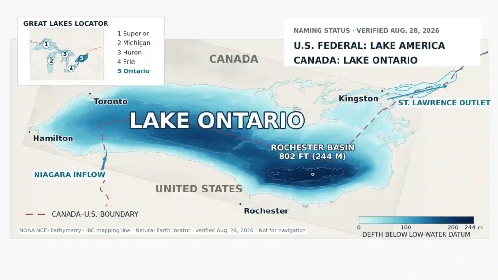
Lake Ontario lies between the Canadian province of Ontario and the U.S. state of New York. It is the easternmost and most downstream of the five Great Lakes. In physical terms, it is a large freshwater open-drainage lake: water enters through rivers and leaves through a surface outlet rather than ending in a closed basin.
| Feature | Verified fact |
|---|---|
| Feature type | Large freshwater, open-drainage lake reshaped by continental glaciation |
| Great Lakes position | Easternmost and most downstream |
| Bordering jurisdictions | Ontario, Canada, and New York, United States |
| Approximate map-reference coordinate | 43.7288° N, 78.1064° W — convert this coordinate |
| Surface area | 7,340 sq mi (18,960 km²) |
| Length | Approximately 193 mi (311 km) |
| Maximum width | Approximately 53 mi (85 km) |
| Average depth | 283 ft (86 m), measured from low-water datum |
| Maximum depth | 802 ft (244 m), measured from low-water datum |
| Volume | Approximately 393 cu mi (1,640 km³), calculated at low-water datum |
| Reference surface elevation | 243.3 ft (74.2 m), the Lake Ontario low-water/chart datum—not a live water-level reading |
| Water-retention time | Approximately 6 years |
| Land drainage area | Approximately 24,720 sq mi (64,030 km²); the EPA figure includes the Niagara River drainage area |
| Principal inflow | Niagara River |
| Outlet | St. Lawrence River |
| U.S. federal name | Lake America, effective August 27, 2026 |
| Canadian official name | Lake Ontario; Lac Ontario in French |
The EPA figure of 24,720 sq mi (64,030 km²) is the land drainage area, including the Niagara River drainage area; it is not the lake-inclusive footprint of the whole basin.
The Great Lakes water route
Water moves down the Great Lakes system from Lake Erie primarily through the Niagara River into Lake Ontario. It then leaves the lake through the St. Lawrence River and continues toward the Atlantic Ocean. The Niagara is the principal inflow, not the only tributary; local rivers, runoff and precipitation also add water.
Lake Ontario is the smallest Great Lake by surface area, but only the second-smallest by volume. Its 283 ft (86 m) average depth allows it to hold about 3.4 times as much water as much shallower Lake Erie, even though Erie covers a larger surface area.
How Deep Is Lake Ontario?
Average depth, maximum depth and the Rochester Basin
Lake Ontario’s average depth is 283 ft (86 m), while its maximum mapped depth is 802 ft (244 m). The average describes the whole basin; the maximum is one deepest area. Most places in the lake are therefore shallower than 802 ft.
The depth figures are referenced to the Great Lakes low-water datum. Lake Ontario’s chart datum is 243.3 ft (74.2 m) on IGLD 1985. The actual lake level varies relative to that reference and is usually above it, so 802 ft should not be treated as an exact live surface-to-bottom measurement on every date.
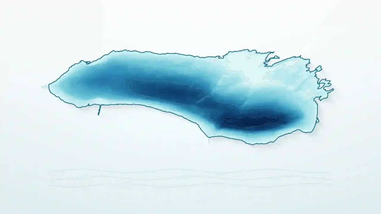
The deepest area lies in the Rochester Basin, south of the international boundary on the New York side. NOAA bathymetry shows that this southern basin contains the lake’s greatest depths. Nearshore shelves and the eastern Kingston-area basins are much shallower, so a bathymetric map communicates the lake’s shape more accurately than one depth number.
Who Owns Lake Ontario?
No single country “owns” Lake Ontario as one undivided national lake. The international boundary crosses the water, and Canada and the United States exercise jurisdiction on their respective sides, subject to treaties, domestic law and binational arrangements. The International Boundary Commission publishes a digital boundary shapefile for mapping use; that file does not itself legally define the boundary, and the boundary was not changed by the 2026 naming order.
Approximately 52% of the lake’s surface area lies on the Canadian side and 48% on the U.S. side. Those percentages describe surface area divided by the boundary. They should not be treated as complete ownership shares, water-volume shares, economic shares or naming rights.
The White House order claims that the United States contains most of the lake’s volume because the deepest parts lie south of the boundary. Comparing NOAA bathymetry with the International Boundary Commission’s digital mapping line confirms that the lake’s deepest area, within the Rochester Basin, lies on the U.S. side, but neither the order nor the cited federal lake data provide a transparent cross-boundary volume calculation. For that reason, this article does not publish an exact U.S.–Canadian volume percentage.
Even a validated volume majority would not give one government authority over the other country’s geographic-name records. Naming jurisdiction, territorial jurisdiction and water volume are different questions.
The 1909 Boundary Waters Treaty protects navigation and establishes rules for uses, diversions and pollution of shared waters. Later agreements and the International Joint Commission support binational water-quality and flow management. The U.S. naming action contains no provision amending those systems.
How Lake Ontario Formed
Lake Ontario occupies an older bedrock and drainage low that repeated Pleistocene continental glaciers deepened and reshaped. Thick moving ice scoured bedrock, widened and overdeepened parts of the basin, redirected drainage and left till, clay and other sediments. The glaciers did not cut the entire basin from featureless rock.
That combination of erosion and deposition explains why the floor contains both deep basins and ridges. Lake Ontario is a large-scale example of how glacial deepening and overdeepened basins can modify a pre-existing landscape.
During deglaciation, a higher water body known as Glacial Lake Iroquois occupied the basin while ice obstructed the modern St. Lawrence outlet. As the ice margin retreated, lower outlets opened, water levels changed, glacial sediments accumulated and the land rebounded unevenly after the ice load disappeared. Upper Great Lakes drainage later returned through the Ontario basin, helping establish the modern lake-and-river system.
Water Levels, Inflow, Outflow and Winter
Why the lake level changes
Lake Ontario’s level reflects the balance between water entering and leaving. The main controls are Niagara River inflow, precipitation on the lake, runoff from the surrounding basin, evaporation and outflow through the St. Lawrence River. The International Joint Commission reports that Lake Erie supplies about 85% of total inflow on average, with most of that water moving through the Niagara River.
St. Lawrence outflow is regulated primarily at the Moses-Saunders dam under the current Plan 2014 system, but regulation influences rather than fully controls lake levels. Wet and dry periods, seasonal evaporation, snowmelt, storms and upstream conditions can overwhelm the effect of operational adjustments. Wind and air-pressure changes can also push water temporarily toward one shore.
The commonly listed elevation of about 243 ft (74 m) is the low-water/chart reference, not today’s level. Any current water-level claim needs a date, station and datum.
Ice cover and lake-effect snow
Lake Ontario’s depth gives it a large heat-storage capacity, and its relatively small surface area limits heat loss compared with its volume. NOAA therefore identifies it as the Great Lake with generally the least ice cover. Harbors, bays and nearshore water can freeze, but complete lake-wide ice cover is uncommon.
Unfrozen water can remain warmer than winter air. When cold air crosses the open lake, it absorbs heat and moisture, which can organize into lake-effect snow bands. Wind direction determines where they land, but parts of the southern and eastern New York shoreline and areas farther downwind can receive heavy snow.
Cities, Canals and Why the Lake Matters
Cities around the shoreline
Toronto, Mississauga and Hamilton form the largest urban concentration around the western Canadian shore. Kingston stands near the lake’s outlet into the St. Lawrence River. Rochester is the largest U.S. city directly on the lake. Oswego is a smaller lake-and-canal port, while Sackets Harbor is a smaller historic harbor community.
Seaway and canal connections
Lake Ontario is the downstream Great Lakes gateway within the Great Lakes–St. Lawrence Seaway. The Welland Canal connects it with Lake Erie while bypassing Niagara Falls. The Rideau Canal provides navigation between Lake Ontario at Kingston and the Ottawa River at the Canadian capital, Ottawa.
Why Lake Ontario matters
The lake supplies drinking water, supports ports and industry, links inland shipping to the Atlantic, sustains commercial and recreational fisheries, and provides shoreline recreation. Its wetlands are important habitat and natural water filters. The lake also moderates nearby temperatures and shapes local snowfall, so its influence extends beyond the water’s edge.
Environmental Pressures and Restoration
Lake Ontario sits at the downstream end of the Great Lakes chain, so it receives water—and some accumulated pressures—from the upper lakes as well as its own watershed. This does not make water quality uniform: conditions differ between open water, urban harbors, tributary mouths, bays, beaches and wetlands.
Major management concerns include invasive species that alter food webs, localized nutrient and bacterial pressures, nuisance algae in some nearshore areas, sporadic cyanobacteria blooms in some embayments, legacy contaminants in some sediments, and the loss or modification of shoreline and coastal-wetland habitat. Offshore and nearshore conditions can differ sharply. Climate-related changes in temperature, precipitation and ice can interact with those existing pressures.
Canada and the United States address lake-wide priorities through the Great Lakes Water Quality Agreement and the Lake Ontario Lakewide Action and Management Plan, while local and regional programs target contaminated areas, tributaries, wetlands and nearshore restoration. The work is ongoing rather than a claim that every part of the lake has the same problem or condition.
Why Is It Called Ontario?
The name Ontario is generally traced to an Indigenous Iroquoian form, commonly associated with Wendat. Sources do not agree on one spelling or literal translation. Published interpretations include “great lake,” “beautiful lake” and “sparkling water.” The differences reflect recorded forms, source attributions, spellings and English glosses, so none should be presented as the only unquestionable meaning.
The geographic name is older than both modern countries. Written seventeenth-century records used Ontario for the region and the lake long before the U.S. Declaration of Independence in 1776 and Canadian Confederation in 1867. The lake name also came before the modern Province of Ontario; the province inherited the established geographic term, not the other way around.
This long Indigenous and colonial-era naming history is why the 2026 federal change carries cultural meaning beyond a label on a map. Canadian and Wendat representatives responded by emphasizing the name’s Indigenous roots and its long use before either modern country existed.
Frequently Asked Questions
Is Lake Ontario now officially called Lake America?
Lake America is the official U.S. federal name as of August 27, 2026. Lake Ontario remains the official Canadian English name, so the correct answer depends on the naming authority.
Why are there two official names?
The United States and Canada maintain separate geographic-name systems. The U.S. federal system changed its name for the feature, while Canada’s system did not.
Did Trump rename the whole lake or only the U.S. side?
The U.S. federal order applies Lake America to the whole transboundary lake as one feature in federal nomenclature. It did not create a separately named U.S. half; Canada still applies Lake Ontario to the whole feature in its own system.
Can the United States rename a lake shared with Canada?
The United States can standardize the name used by its federal agencies. It cannot force Canada to change Canadian records or require states, international bodies and private mapmakers to follow federal usage.
What will Google Maps and other map services call it?
Private map providers make their own labeling decisions and may use Lake Ontario, Lake America, both names or region-dependent labels. The federal order does not control them, and any platform observation should be checked by date and user region rather than treated as permanent.
Who owns Lake Ontario?
The international boundary crosses the lake. Canada and the United States exercise jurisdiction on their respective sides under domestic law, treaties and binational arrangements; a surface-area percentage is not complete ownership of one shared water body.
Is Lake Ontario in Canada or the United States?
It is in both. The Canadian side borders Ontario, and the U.S. side borders New York.
How deep is Lake Ontario?
Its average depth is 283 ft (86 m), and its maximum mapped depth is 802 ft (244 m), referenced to the lake’s low-water datum.
Is it the smallest Great Lake?
Yes by surface area. By volume it is second-smallest, ahead of Lake Erie, because Lake Ontario is much deeper.
Why is it called Ontario?
The name comes from an Indigenous Iroquoian language tradition, commonly associated with Wendat. Translations vary and include “great lake,” “beautiful lake” and “sparkling water.”
Which came first, the lake name or Ontario Province?
The lake name came first. Ontario was documented as a geographic name in the seventeenth century, while the Province of Ontario was established at Canadian Confederation in 1867.
Where does Lake Ontario drain?
It drains through the St. Lawrence River, which carries the Great Lakes system toward the Atlantic Ocean.
Is Lake Ontario freshwater?
Yes. It is a large freshwater, open-drainage lake within the Laurentian Great Lakes system.
Does Lake Ontario freeze?
Nearshore areas, bays and harbors freeze, but complete lake-wide ice cover is uncommon. Its depth stores heat, allowing open water to persist through many winters and support lake-effect snow.
What Did We Learn Today?
Lake Ontario is one transboundary freshwater lake shared by Ontario and New York, with water moving from Lake Erie through the Niagara River and onward through the St. Lawrence. Its deep glacial basin makes it small by area but relatively large by volume. Since August 27, 2026, U.S. federal records call the whole feature Lake America, while Canadian records retain Lake Ontario; that naming split did not alter the border, jurisdiction or binational water-management system.
Sources & Data Notes
Stable measurements use rounded EPA and NOAA reference values. The listed 24,720 sq mi (64,030 km²) figure is EPA’s land drainage area, not the lake-inclusive basin footprint. Depths are measured from Lake Ontario’s low-water datum, and 243.3 ft (74.2 m) is that chart reference—not a live lake level. Naming status was checked August 28, 2026 against the White House order, Interior order, GNIS and Canadian records. The lake order’s executive-order number is intentionally omitted: Secretarial Order 3453 cites “EO 14420,” but the Federal Register assigns EO 14420 to a different August 10 order, and a separate White House page also duplicates that number. The title and implementation are verified, but the numerical citation should be rechecked after the federal record is reconciled. GNIS retained Lake Ontario as a variant when checked even though the presidential text directed removal of references from GNIS.