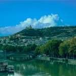
Lake Sevan is a high-altitude freshwater lake at ~6,235 ft (≈1,900 m) above sea level, covering about 493 sq mi (≈1,278 km²) as of 2025. It’s Armenia’s largest lake and the biggest in the Caucasus, draining mainly via the Hrazdan River and famed for the Sevanavank monastery on its peninsula.
Why Lake Sevan Matters
Lake Sevan is one of the largest high-altitude (alpine) freshwater lakes in Eurasia, the largest body of water in Armenia and the wider Caucasus. Its position at roughly 1,900 m (6,235 ft) gives it a crisp climate and extraordinary clarity on calm days. Historically, the lake has been a strategic water resource for irrigation and hydropower as well as a cultural icon in Armenian literature and faith. :
Beyond beauty, Sevan is protected as Sevan National Park (since 1978) and recognized internationally as Ramsar site no. 620—wetlands of global importance. Together, these designations anchor conservation and visitor management across shoreline zones, islands/peninsula, and wetlands.
Two natural basins: “Major” and “Minor” Sevan
Sevan comprises two connected basins historically described as Major (southeast) and Minor (northwest), with an overall length of ~46 mi (74 km) and a maximum width near 20 mi (32 km). This morphology shapes winds, wave patterns, and boating routes—and explains the lake’s famously different light across its two halves.
| Metric | Value (as cited) |
|---|---|
| Elevation | ≈6,235 ft (≈1,900 m) |
| Surface area (2025) | ≈493 sq mi (≈1,278 km²) |
| Max / mean depth | ≈260 ft / 88 ft (≈79.4 m / 26.8 m) |
| Volume | ≈7.97 cu mi (≈33.2 km³) |
| Basin area | ≈1,823 sq mi (≈4,721 km²) |
| Main outflow | Hrazdan River (10–15% of outflow; most loss by evaporation) |
| Ramsar status | Site no. 620 (Wetland of International Importance) |
Sources include Armenia’s Hydrometeorology & Monitoring Center (area/elevation), EUWI+ Sevan Basin plan (basin area/length–width), and encyclopedic summaries (depth/volume/outflow).
Shape, Size & Water: How Sevan Works
Sevan’s water balance is unusual: around 28 rivers and streams feed the lake, but only a small share exits through the Hrazdan River—most water leaves by evaporation in the dry, sunny season. Today’s mapped surface area clusters near ~1,278 km² (493 sq mi), with a maximum depth near 79–83 m (≈260–272 ft) and mean depth ≈27 m (≈88 ft).
During the Soviet period, large withdrawals for irrigation and hydropower lowered the lake by ~20 m and cut volume by >40%. To stabilize levels, engineers later brought water into Sevan through long transfer tunnels, most notably the 48.3 km (30 mi) Arpa–Sevan tunnel (completed 1981), while the Sevan–Hrazdan HPP cascade regulates outflow. These interventions halted decline; since the early 2000s the lake has generally trended upward year-to-year.
Arpa–Sevan & Vorotan–Arpa transfers and the Sevan–Hrazdan cascade
The Arpa–Sevan tunnel diverts water from the Arpa and Yeghegis rivers. A linked scheme (Vorotan–Arpa) can also route water toward the Arpa system, increasing flexibility during dry years. The downstream Sevan–Hrazdan hydropower cascade integrates energy generation with level management—always a policy balancing act between ecology, power, and agriculture.
Climate & seasons on the shore
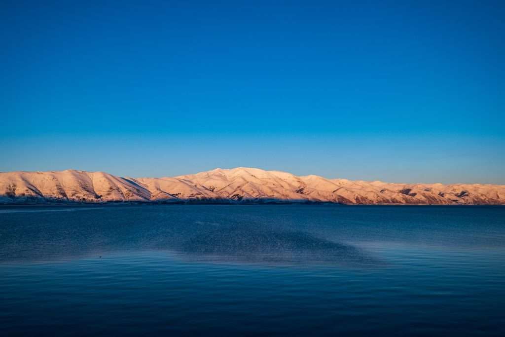
At ~1,900 m (6,235 ft), summers are pleasantly cool and breezy; winters are crisp, with ice forming in coves. Clear days produce intense alpine sun—pack sunscreen and layers even in July. (For water quality advisories, check Armenia’s Hydrometeorology & Monitoring Center updates.)
Nature & Conservation: From “Blue Pearl” to Lab for Recovery
Ecologically, Sevan is a living classroom. It is part of the Ramsar List and protected within Sevan National Park. The lake supports migratory waterbirds and native fish, but several endemics have declined sharply. Cyanobacterial (blue-green algae) blooms have recurred since 2018, tied to nutrient enrichment; remote-sensing studies show bloom variability year-to-year. Encouragingly, 2025 ministry briefings reported relatively low bloom intensity.
Sevan trout (Salmo ischchan) at risk—what’s being done
The iconic “ishkhan” (Sevan trout) is critically endangered and the focus of hatchery releases and habitat protection. Over the 20th century, introductions (e.g., whitefish) plus falling water levels disrupted native spawning. Conservation groups and state agencies are restoring flows and stocking fry to rebuild the population.
History & Human Footprint
Sevan’s modern story is human-made. A 1930s megaproject deepened the Hrazdan channel and began aggressive drawdown for hydropower and irrigation. By the late 20th century, the lake had lost around 20 m of level and more than 40% of volume. The Arpa–Sevan tunnel (approved 1961; completed 1981) marked a policy pivot toward stabilization and eventual recovery.
Since 2001, multi-year hydrology has generally favored a gradual rise. The Hydrometeorology & Monitoring Center reported the lake was ~22 cm higher at end-2024 than a year earlier, with level readings around 1,900.4 m. Projections for 2025 suggested a further seasonal rise in late spring/early summer.
| Year | Event |
|---|---|
| 1933–1960s | Major withdrawals for irrigation/HPP; level drops markedly. |
| 1961 | USSR approves Arpa–Sevan tunnel to replenish Sevan. |
| 1978 | Sevan National Park established to protect the lake and shore. |
| 1981 | Arpa–Sevan tunnel completed (~48.3 km / 30 mi). |
| 1993 | Lake Sevan designated Ramsar site no. 620. |
| 2018→ | Recurring cyanobacterial blooms begin; monitoring intensifies. |
| 2024–2025 | Level rises ~22 cm (2024); 2025 bloom intensity reported low. |
Visiting Lake Sevan
How far is it from Yerevan? The lakeshore is roughly 37–43 mi (60–70 km) from central Yerevan by road. Public buses and minibuses operate frequently, and a seasonal weekend train runs toward Sevan/Shorzha. Typical travel times range from ~1–1.5 hours by bus/minibus to ~2–3.5 hours by train depending on service.
Best time to go. Late spring to early autumn offers the mildest weather and beach access; even then, the water stays brisk. Always check local advisories for water-quality updates before swimming (especially after heat waves). The Hydrometeorology & Monitoring Center posts regular summaries.
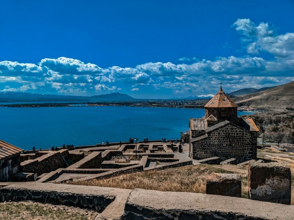
Sevanavank monastery (founded 874 by Princess Mariam) crowns the peninsula with sweeping views; Noratus cemetery (southwest shore) holds hundreds of khachkars (carved cross-stones). Both can be covered in one relaxed day from Yerevan by car or organized tour.
One-Day Micro-Itinerary (easy pace)
- 08:30 — Depart Yerevan (M-4). Scenic pull-offs appear after the pass.
- 10:00 — Sevanavank: monastery views over “Minor Sevan.” Allow 60–90 minutes for steps, photos, and the small museum.
- 12:00 — Lakeside lunch near the peninsula. Try trout or crayfish; ask whether it’s farmed vs. wild.
- 14:00 — Noratus khachkar field (≈18 mi / 30 km from Sevanavank): Armenia’s largest collection of carved cross-stones.
- 16:00 — Beach stop on the north shore (wind-protected coves are calmer). Optional coffee stop in Sevan town.
- 18:00 — Drive back to Yerevan before mountain dusk.
Practical tips
- Swimming: Use signed public beaches; skip the water if you see scum or strong odors. Check recent advisories from the Hydrometeorology & Monitoring Center.
- Sun & altitude: UV can be fierce. Sunscreen, hat, and water are non-negotiable.
- Respect: Monasteries are active religious sites—modest dress is appreciated.
- Leave no trace: Winds can scatter litter; pack it out.
| Mode | Typical Time (one way) | Indicative Cost | Notes |
|---|---|---|---|
| Minibus (marshrutka) | ~1–1.5 hours | ≈1,000–2,000 AMD (≈$2.50–$5.00) | Frequent departures from Yerevan’s northern stations |
| Train (seasonal weekends) | ~2–3.5 hours | Varies by service | Scenic; fewer departures |
| Shared taxi | ~1–1.25 hours | By seat; negotiated | Faster but depends on filling seats |
| Private taxi/ride-hailing | ~1–1.25 hours | Market rates | Door-to-door convenience |
| Self-drive | ~1–1.25 hours | Fuel/toll as used | M-4 highway; watch for gusty crosswinds |
Key Facts Table (Quick Reference)
| Metric | Value | Notes / Source |
|---|---|---|
| Coordinates | ≈40.32° N, 45.35° E | Decimal of 40°19′N 45°21′E. |
| Elevation (Dec 2024) | ≈6,235 ft (≈1,900.4 m) | Hydromet monthly reports. |
| Surface area (Sep 2025) | ≈493 sq mi (≈1,278 km²) | Hydromet water-balance table. |
| Max / mean depth | ≈260 ft / 88 ft (≈79.4 m / 26.8 m) | Encyclopedic/technical summaries. |
| Volume | ≈7.97 cu mi (≈33.2 km³) | As above. |
| Inflow rivers | ~28 | Most loss by evaporation; Hrazdan drains 10–15%. |
| Distance from Yerevan | ~37–43 mi (≈60–70 km) | Road distance via M-4. |
| Protection | Sevan National Park; Ramsar site no. 620 | Official park & Ramsar RSIS. |
FAQ
Is Lake Sevan freshwater or saltwater?
Freshwater. Despite high elevation and large size, Sevan is a freshwater alpine lake with very low salinity (≈0.7%), fed by ~28 rivers and drained mainly by evaporation and the Hrazdan River.
Why did Lake Sevan’s level fall—and why is it rising again?
20th-century withdrawals for irrigation and hydropower lowered the lake ~20 m and cut volume >40%. Transfer tunnels (e.g., the 48.3 km Arpa–Sevan) and tighter outflow rules later slowed and reversed the decline; 2024 ended ~22 cm higher than 2023.
Is it safe to swim?
In summer many locals swim at public beaches; however, conditions vary with weather and algae. Always check recent advisories from Armenia’s Hydrometeorology & Monitoring Center, and avoid scummy or discolored water during bloom events.
What wildlife is Sevan known for?
The lake and wetlands host migratory waterbirds. Fish once dominated by endemic Sevan trout have shifted; conservation now targets trout recovery while managing introduced species and crayfish fisheries.
How do I get to Sevan from Yerevan without a car?
Buses/minibuses run frequently (≈1–1.5 hours). A seasonal weekend train operates in warm months to Sevan/Shorzha (≈2–3.5 hours depending on service). Tours and taxis are widely available.
What are the must-see spots on a day trip?
Sevanavank monastery for views and history; Noratus khachkar field; wind-swept beaches on the northern shore; optional detours to Dilijan’s forests. Sevanavank (874 CE) sits on the lake’s peninsula and is one of Armenia’s most visited religious sites.
What Did We Learn Today?
- Lake Sevan is Armenia’s largest lake and the biggest in the Caucasus—an alpine freshwater body at ≈1,900 m (6,235 ft).
- Current mapped area is ≈1,278 km² (493 sq mi) with gradual multi-year recovery in water level.
- Two basins (Major/Minor Sevan) shape winds, waves, and boating routes; the lake is ~74 km long.
- It’s a protected Ramsar site inside Sevan National Park with global ecological value.
- Visitors can combine Sevanavank, beaches, and Noratus in a single day from Yerevan.