A famous monument can lie close to an eclipse route without experiencing totality. On August 2, 2027, that distinction separates the temples at Luxor from the pyramid fields near Cairo, and northern Morocco from Granada in southern Spain.
The August 2, 2027 eclipse brings totality to selected World Heritage points at Tétouan, Djémila, Timgad, El Jem, Karnak, Luxor Temple and Historic Jeddah. The Granada and Giza reference points compared here see only a partial eclipse. These are point-specific calculations, not a guarantee for every part of a heritage property or an offer of visitor access.
How to use this article: Match the map to the numbered table, compare the near-edge example, and read the calculation limits before using a result for planning.
1. The Heritage Map and Its Numbered Key
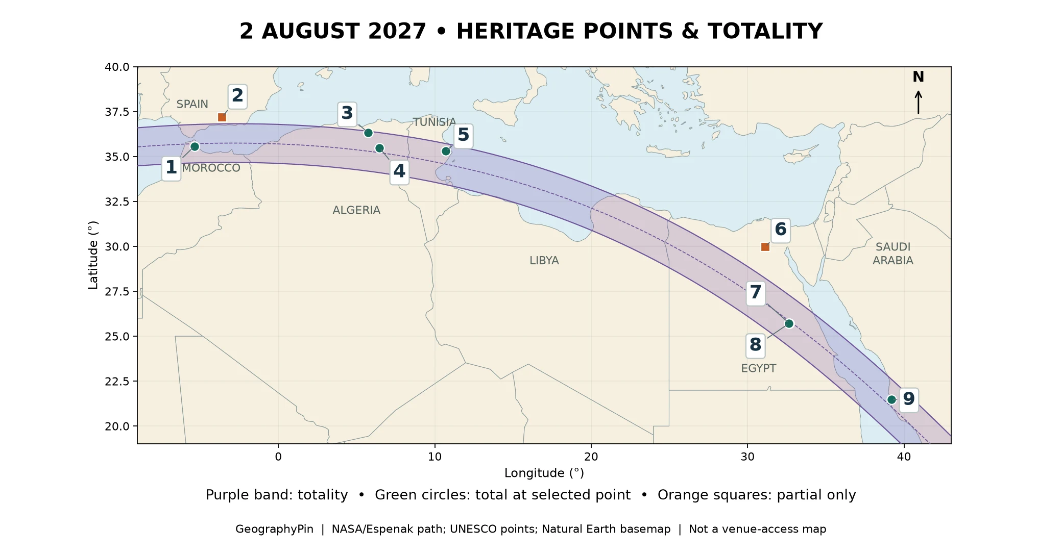
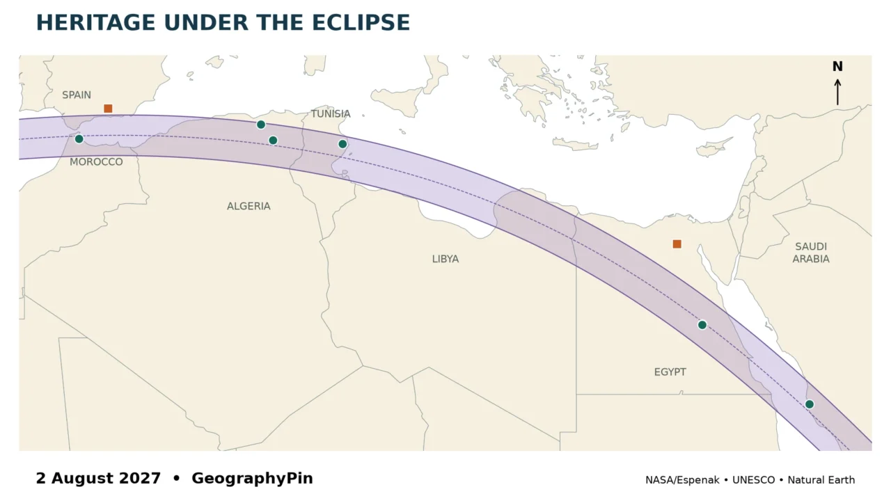
The shaded band follows NASA’s published 2027 eclipse-path coordinates. It crosses the western Mediterranean region, North Africa and the Red Sea region shown here; the full eclipse track extends farther across the Atlantic and Indian oceans. This is a selected heritage comparison, not a complete inventory of every World Heritage property touched by the shadow.

Map numbers, locations and approximate totality
Each row refers to the stated UNESCO geographical reference point. For Ancient Thebes, separate registered temple components are used. A point is a transparent calculation location, not a surveyed observing platform. Durations are rounded to the nearest ten seconds; a dash means there is no total phase at that point.
| Map | Heritage location | Country | Outcome | Totality |
|---|---|---|---|---|
| 1 | Tétouan medina | Morocco | Total | About 4 min 50 sec |
| 2 | Granada heritage reference point | Spain | Partial | — |
| 3 | Djémila | Algeria | Total | About 2 min 00 sec |
| 4 | Timgad | Algeria | Total | About 5 min 20 sec |
| 5 | El Jem Amphitheatre | Tunisia | Total | About 4 min 20 sec |
| 6 | Giza pyramid-field reference point | Egypt | Partial | — |
| 7 | Karnak Temple | Egypt | Total | About 6 min 20 sec |
| 8 | Luxor Temple | Egypt | Total | About 6 min 20 sec |
| 9 | Historic Jeddah | Saudi Arabia | Total | About 6 min 00 sec |
The map shows seven total-eclipse points, not seven separate World Heritage properties: Karnak and Luxor Temple both belong to Ancient Thebes with its Necropolis. The comparison deliberately includes two partial-only points, because identifying a near miss is as useful as finding a long total phase.
2. Totality at Selected Heritage Locations
The seven total-eclipse points do not share one duration. Their positions across the shadow’s width, together with the eclipse geometry along its track, produce different intervals of darkness. Being inside the band is the first test; being near its center is a separate question.
Tétouan and the Algerian archaeological sites
The medina reference point at Tétouan, in northern Morocco, falls well inside the band. Its calculated total phase is about 4 minutes 50 seconds. The selection connects the eclipse with a historic urban property rather than treating all of Morocco as one observing location.
Farther east, the Timgad reference point has about 5 minutes 20 seconds of totality. Djémila is also inside the path, but it sits much nearer the northern edge. Its approximately 2-minute total phase is a useful reminder that two archaeological sites in the same country can have very different eclipse circumstances.
Djémila: inside the band does not mean near the center
Djémila is the clearest near-edge example in this selection. In the Algeria–Tunisia close-up, point 3 lies just below the northern boundary, while Timgad, point 4, sits farther into the band. The shorter result at Djémila comes from the geometry at its own coordinate, not from a different type of eclipse.
Do not read the thickness of a printed boundary line as a precise site boundary. The plotted path is an approximation between NASA’s supplied vertices, and the point calculation is more informative than deciding whether a small symbol appears to overlap the shading. For a specific terrace, road or hotel, calculate that exact position again.
El Jem, Karnak and Luxor Temple
The Amphitheatre of El Jem reference point in Tunisia has roughly 4 minutes 20 seconds of totality after rounding. This is the amphitheatre’s registered geographical point, not a promise that its interior, upper seating or surrounding streets will be available for eclipse viewing.
In Egypt, the registered Temple of Karnak and Temple of Luxor points both have approximately 6 minutes 20 seconds of totality. They are components of the same World Heritage property but are calculated separately. Neither result should be assigned automatically to the entire Ancient Thebes necropolis, which occupies a much larger area across the Nile.
Egypt’s National Research Institute of Astronomy and Geophysics also gives about 6 minutes 20 seconds for Luxor at city scale. That provides a useful broad comparison, but it does not remove the need to distinguish an individual temple coordinate from a city label.
Historic Jeddah on the Red Sea
The Historic Jeddah reference point is inside totality, with approximately 6 minutes at the coordinate used here. Its location on the eastern side of the Red Sea makes it a different geographic part of the eclipse route from the North African sites.
A historic urban area contains streets, roofs, courtyards and buildings with different sky obstructions. The calculation establishes the astronomical outcome at the coordinate. It does not establish a clear line of sight from every courtyard or a right to enter a particular property.
3. Two Famous Places That Miss Totality
Granada and Giza show why a destination’s fame is irrelevant to whether the Moon covers the entire Sun. Both reference points in this comparison lie outside the northern limit.
Granada is not the same as Spain’s totality zone
The UNESCO reference point for Alhambra, Generalife and Albayzín, Granada lies north of the totality band. It experiences a partial eclipse, not a short total eclipse. A map showing totality across part of southern Spain must not be read as including every southern Spanish city.
The distinction matters even when a partial eclipse covers most of the solar disk. A remaining sliver of the Sun is still a partial phase; it does not provide the same naked-eye viewing interval as totality. Do not remove solar filters simply because the surroundings become dimmer.
The Giza pyramid-field point is not Luxor
The reference point for the pyramid-field component near Giza also falls outside the totality band. It is far north of the Karnak and Luxor Temple points. “Egypt is in the eclipse path” is therefore too broad to answer a question about the pyramids.
The UNESCO property name extends from Giza to Dahshur. The plotted result is for its published component reference point, not a claim that one coordinate represents every pyramid, boundary or visitor area within that extensive property. Keep the point-level result separate from the larger heritage designation.
For the wider regional setting, compare the Mediterranean countries map. Political and coastal regions help orient the route, but an eclipse shadow does not follow their borders.
4. How the Point Calculations Were Made
The map and table answer related but different questions. The map shows the shadow’s geographic corridor. The calculations test nine specified coordinates against the eclipse geometry. Neither the heritage-property name nor the nearest city was used as a substitute for that coordinate test.
A reproducible point comparison
UNESCO’s geographical-data tables supplied the selected property or component coordinates. NASA’s August 2, 2027 Besselian elements supplied the mathematical description of the moving shadow. GeographyPin calculated the observer’s position on an ellipsoid, then solved numerically for the beginning and end of the total phase at each point.
The calculation uses NASA’s published value of 71.7 seconds for ΔT, the difference between the time scales used for the celestial calculation and Earth’s rotation. Results were checked against the mapped north and south limits. The regional pattern also agrees with the National Solar Observatory’s 2027 overview. This is not an independently observed event: all 2027 values remain predictions.
Durations in the reader table are rounded to ten seconds. The supporting coordinate file retains the input points and more precise model results for reproducibility; extra decimal places there describe the calculation, not a promise of equivalent real-world accuracy.
What the model does not include
The point calculations assume an observer at sea level and a smooth lunar limb. They do not model local terrain, buildings, cloud, atmospheric refraction or the Moon’s detailed mountains and valleys. NASA notes that lunar-limb corrections can change contact times by a few seconds. These educational estimates are therefore not a substitute for a final observing-site calculation.
The map is drawn in longitude and latitude with a fixed display aspect. It is intended to locate the path, not to measure ground distances from the screen. Borders come from Natural Earth’s small-scale basemap and are contextual, not a determination of sovereignty or visitor access.
Near an edge, small changes of position matter much more than they do near the middle of the band. A heritage reference point cannot establish conditions over a large or multi-part property. The correct follow-up is to verify the exact intended outdoor location, its elevation and its local horizon with a current specialist calculator.
5. Visibility Is Not Permission to Observe
This is a geographic comparison, not a list of bookable eclipse venues. A place can be astronomically suitable yet inaccessible, obstructed, reserved for an event or closed to visitors. No opening arrangements or eclipse admission rights are implied by inclusion.
Before making a reservation, check the relevant monument operator, official tourism authority and your government’s travel advice. Verify the exact address rather than relying on a city pin. Then check the intended observing position’s sky view and the practical arrangements for heat, shade, water and return transport.
NASA’s eclipse-safety guidance distinguishes totality from every partial phase: use proper solar viewers for direct viewing of the uneclipsed or partially eclipsed Sun. Ordinary sunglasses are not safe solar filters. Cameras, binoculars and telescopes need appropriate solar filters secured over the front of those instruments; do not look through them while merely wearing eclipse glasses.
At a partial-only location such as the two orange points, there is no totality interval in which the solar disk is completely covered. At a total-eclipse location, follow a reliable local contact-time and safety plan rather than treating this rounded comparison table as a second-by-second viewing instruction.
Frequently Asked Questions
Is this a complete list of World Heritage sites in the 2027 eclipse?
No. It is a selected, reproducible comparison of nine geographical points. Seven are total and two are partial-only. Two of the total points belong to the same World Heritage property.
Why are no local clock times listed?
The main task is comparing locations and totality duration. Local clock rules and the exact observing position must be checked for a final itinerary; a rounded duration is not an observing timetable.
Does the longest totality automatically make the best observing site?
No. A clear sky, an unobstructed view and lawful, practical access can matter more than gaining a few extra seconds. This comparison does not rank travel safety, weather prospects or venue quality.
What Did We Learn Today?
An eclipse map becomes more useful when its labels refer to explicit points. Tétouan, Djémila, Timgad, El Jem, Karnak, Luxor Temple and Historic Jeddah have totality at the selected coordinates, while the Granada and Giza points do not. Durations vary across the band, and neither a heritage designation nor a map marker guarantees access or an unobstructed observing site.
Sources & Data Notes
GeographyPin’s comparison uses NASA/Espenak’s 2027 path and Besselian elements, UNESCO property/component coordinates linked in the table, and a Natural Earth basemap. Calculations assume sea level and a smooth lunar limb; displayed durations are rounded to ten seconds. Maps and results are predictions for August 2, 2027, not live conditions, surveyed venue plans or access confirmations.
- NASA/Espenak: August 2, 2027 path, calculation conventions and limitations
- NASA: Besselian elements for the August 2, 2027 eclipse
- National Solar Observatory: 2027 eclipse overview
- Egyptian National Research Institute of Astronomy and Geophysics: Luxor eclipse overview
- Natural Earth: public-domain basemap terms
- NASA: Eclipse Viewing Safety