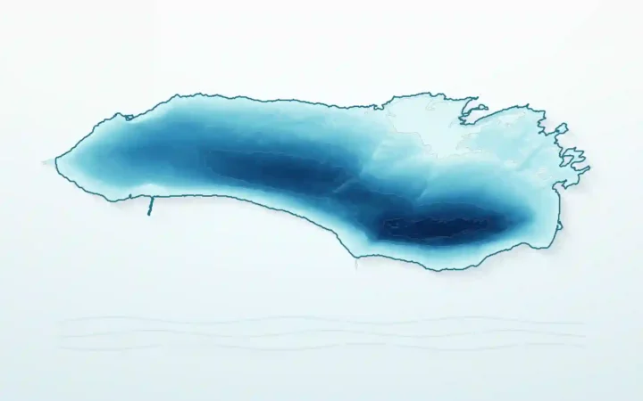
Xitai Jinaier Lake (西台吉乃尔湖), also called West Taijinar or West Taijinel Lake, is a shallow, highly saline lake-and-playa system in Qinghai’s Qaidam Basin, China. G315 crosses its shifting water and salt surface; aerial images can show two colors, but no single published cause explains that contrast in every season or photograph.
How to use this article: Check the name variants, compare the dated measurements, decode the famous aerial view, or jump to visitor safety.
Where Xitai Jinaier Lake is—and what its names mean
Xitai Jinaier lies near the center of the Qaidam Basin, a high, internally drained basin in northwestern Qinghai Province. The lake itself is generally placed within the Da Qaidam Administrative Committee area of Haixi Mongol and Tibetan Autonomous Prefecture. Some route descriptions use the better-known city name Golmud loosely, but that should not be taken as the lake’s precise administrative location.
| Field | Defensible description |
|---|---|
| Chinese name | 西台吉乃尔湖 |
| Location | Qaidam Basin, Haixi Mongol and Tibetan Autonomous Prefecture, Qinghai, China |
| Administration | Da Qaidam Administrative Committee area |
| Approximate elevation | Historical references posted or published in 2009–2014: 8,786–8,789 feet (2,678–2,679 meters), depending on the stated water level |
| Lake type | Endorheic magnesium-sulfate-subtype salt-lake and playa system |
| Main replenishment | River inflow from the Nalenggele–West Taijinar system, seasonal runoff, and groundwater |
| Road | China National Highway G315 on a raised roadbed |
On a China map, begin with Qinghai in the north-central part of the country. Within Qinghai, move west into the Qaidam Basin; Xitai Jinaier is west of East Taijinar Lake and lies along G315. A Chinese Academy of Sciences profile posted in 2009 gives a historical coordinate envelope of roughly 93°16′–93°29′ E and 37°39′–37°47′ N, which is more honest than assigning one point to a water body whose margins move.
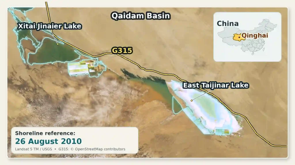
The 2010 shoreline is a dated reference, not a claim about today’s lake. A peer-reviewed Landsat study mapped about 48.0 square miles (124.4 square kilometers) of water that year and no natural-water polygon in its 2015 scene, illustrating why an undated outline would mislead.
One lake, several English names
The first Chinese character, 西 (xi), means “west.” It distinguishes this western basin from Dongtai Jinaier—东台吉乃尔湖, with 东 (dong) meaning “east.” English sources then transliterate the remaining sounds in several ways.
| Name or spelling | How to read it |
|---|---|
| 西台吉乃尔湖 | Chinese written form |
| Xitai Jinaier Lake | Common close transliteration of the Chinese name |
| Xitai Jiner, Xitai Jinair, Xitai Jinaer | Shortened or alternative romanizations |
| West Taijinar, West Taijinel, West Taijinair | Forms that translate the west marker and vary the transliteration |
| West Taijinel Salt Lake | A spelling common in English-language scientific papers |
These names do not identify five different lakes. They are spelling conventions for the western Taijinar basin. East Taijinar Lake is the separate eastern member of the system and should never supply measurements for the western lake.
A shallow salt lake with a complicated water balance
Xitai Jinaier is an endorheic lake: water reaches the basin, but no river carries it onward to the ocean. A 2021 PLOS ONE study describes its principal surface-water connection as the West Taijinar branch of the Nalenggele River system, flowing north from the Kunlun Mountains. Seasonal runoff and groundwater also replenish the lake and adjacent salt marsh.
Water then leaves mainly through evaporation. In this dry, windy basin, evaporation greatly exceeds precipitation, concentrating dissolved material into brine and leaving salts behind as the water retreats. That is the same basic concentration process discussed in GeographyPin’s guide to the saltiest lakes in the world. The Dead Sea offers a familiar closed-basin comparison, although its chemistry, scale, setting, and measurements are not interchangeable with Xitai Jinaier’s.
The lake is classified as a sulfate-type, magnesium-sulfate-subtype salt lake. This is a hydrochemical classification based on the balance of dissolved ions; it does not mean that the water is pure magnesium sulfate or that magnesium alone determines its color. The basin contains surface brine, brine within salt-bearing sediments, exposed salt crust, wet marshy ground, and areas reshaped for mineral production.
How West and East Taijinar are related
West and East Taijinar are terminal parts of a formerly more connected lake, river, wetland, and salt-flat system. The Taijinar branches delivered Nalenggele water toward the two named basins, while shallow channels and low salt surfaces allowed the destination of floodwater to change. They are better understood as dynamic remnants within one drainage system than as two permanent bowls with fixed shores.
Human works have altered that connectivity. The 2018 Landsat analysis reported barriers near West Taijinar after 2003 and a dam at East Taijinar in 2008, with water redirected toward channels, Duck Lake, and Yiliping. Flood-control structures can protect industrial brine from dilution, but they can also decide which low basin receives river water. Climate and human management therefore interact: precipitation and mountain runoff matter, but so do diversion, dikes, brine extraction, and evaporation ponds.
Why published lake measurements disagree
There is no honest single “size of Xitai Jinaier Lake” without a date and a definition. A change of less than a foot can move the edge far across a nearly level playa. Satellite analysts, reference-book editors, hydrologists, and mining studies may also measure different things: open water, a water-level contour, natural brine only, the named basin, or managed pond surfaces.
Dated measurements, not permanent specifications
| Source and context | Area or water extent | Other reported measurements |
|---|---|---|
| Chinese Academy of Sciences profile posted in 2009, compiled from older reference works | 31.7 sq mi (82 km²) | Length 6.8 mi (11 km); depth 1.0–1.3 ft (0.3–0.4 m); elevation 8,786 ft (2,678 m) |
| China Rivers and Lakes Encyclopedia, published 2014, at a stated 8,789-ft (2,679-m) water level | 48.6 sq mi (126 km²) | Length 11.6 mi (18.6 km); maximum width 8.1 mi (13 km); volume 302,000 acre-ft (373 million m³) |
| Six Landsat interpretations published in 2018; artificial salt fields excluded | 1976: 6.1 sq mi (15.7 km²); about 1990: 50.7 sq mi (131.4 km²); about 2000: 11.4 sq mi (29.4 km²); 2007: 0.27 sq mi (0.7 km²); 2010: 48.0 sq mi (124.4 km²); 2015: 0 sq mi (0 km²) | Water polygons from six image dates, not an annual average or the full salt-lake production area |
The 2009 institute profile also reported surface-brine mineralization of 336.3 grams per liter, relative density of 1.2255, and pH 7.7. Its underlying sample date is not stated on the web profile, so the value belongs to that historical reference context—not to every part of the lake today. Grams per liter must not be relabeled directly as a weight percentage because a liter of dense brine weighs more than a kilogram.
The Landsat sequence is especially revealing: the mapped water expanded, contracted almost to zero, expanded again, and disappeared from that study’s 2015 natural-water classification. Yet Qinghai’s transport authority reported in May 2023 that the lake’s water level was rising and eroding the G315 road slope and roadbed. “Dry” in one satellite snapshot therefore does not mean that water can never return to this shallow terminal basin.
The main reasons numbers conflict
- Date and season: summer inflow, multi-year precipitation, wind, and evaporation change the open-water edge.
- Water level: a small vertical shift spreads over a wide, flat salt surface.
- Mapped category: one source may include the named basin while another excludes industrial salt fields or counts only visible natural water.
- Infrastructure: dikes, channels, flood-control works, and pumping redistribute surface water and brine.
- Method: field measurements, water-level contours, and satellite thresholds do not draw identical shorelines.
Averaging the published areas would create a number that describes no actual date or condition. The most useful statement is that Xitai Jinaier is very shallow and highly variable, followed by the measurement and its context.
What the famous G315 aerial image actually shows
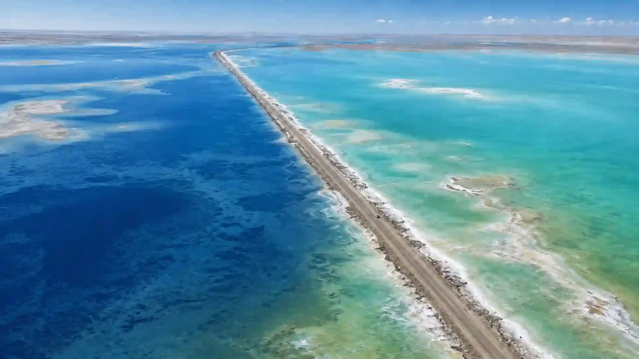
The June 2026 Bing wallpaper titled for the highway through Xitai Jinaier Lake is an oblique aerial view credited to Kaicheng Xu/Getty Images. It is recognizable because a long, nearly straight road divides broad blue-green surfaces. The central line is China National Highway G315—part of the long-distance route across the Qaidam Basin—carried here on a raised embankment rather than a sightseeing bridge.
A four-part image decoder
What to distinguish before interpreting the colors:
- G315 embankment: the narrow, engineered strip carrying the carriageway above the low salt basin.
- Natural shallow brine: irregular water surfaces whose color and margins can change with depth, inflow, wind, and evaporation.
- Exposed salt playa: pale or white surfaces where water has retreated and salts have accumulated.
- Managed ponds or brine fields: rectilinear, diked cells elsewhere in the wider complex; these are industrial surfaces, not naturally shaped lake coves.
G315 crosses this landscape because it is a regional transport corridor through the broad, relatively flat basin. The dramatic water view is a consequence of a road meeting a mobile shoreline, not evidence that the highway was designed as a scenic divider. The 2023 erosion report also shows the practical downside: when water rises, waves and saturation can damage the slope and roadbed.
The Bing photograph is licensed commercial imagery and should not be copied from the wallpaper without the appropriate Getty license. A separate photograph taken on August 8, 2024 is available on Wikimedia Commons under CC BY-SA 4.0; using or cropping it requires attribution to Liuxingy, a link to the license, disclosure of modifications, and distribution of the adaptation under the same license.
Why the two sides can appear different colors
The color contrast is genuine in particular photographs, but it is not a permanent blue-side-versus-green-side property. Published evidence does not establish paired chemistry from both sides at the time and position of the famous aerial image, so assigning one chemical cause would overstate what is known.
A reasoned explanation with several interacting factors
The raised roadbed can slow cross-road exchange except where water passes through culverts or other openings. That separation makes it plausible for the two sides to develop different local conditions, but the road is not a complete laboratory partition and is not, by itself, a proven color formula.
- Water depth: deeper water absorbs and scatters light differently, while very shallow water reveals more of the bottom.
- Brine chemistry and salt precipitation: evaporation and inflow can change the mix of dissolved ions and fine mineral crystals.
- Suspended material: silt, salt particles, and other fine material change how much light the water reflects. Aquatic remote-sensing guidance from the USGS notes that suspended sediment can materially change visible reflectance.
- Lakebed color: pale halite, darker wet sediment, and saline soil can show through shallow, clear water.
- Circulation and inflow: wind, a recent runoff pulse, and the location of channels can distribute water and particles unevenly.
- Sunlight and viewing geometry: sun angle, glare, clouds, camera position, sensor response, and image processing can strengthen or weaken the contrast.
The safest conclusion is therefore conditional: the embankment can help maintain different water masses, while depth, brine composition, suspended material, bottom reflectance, circulation, and lighting together determine the photographed colors. Claims that one side is green because of copper, that one side is fresh water, or that lithium turns the lake blue are not supported by direct site-specific evidence. Nor should a fixed color be assigned to a fixed salt concentration without direct sampling.
Minerals, industry, and ecological protection
The salt lake is valuable because repeated evaporation has concentrated a chemically complex brine. Scientific and institutional sources identify lithium, potassium, boron, magnesium, and common salts in the Xitai Jinaier system. In plain terms, lithium is used in rechargeable batteries; potassium compounds are important fertilizer inputs; boron compounds serve glass and chemical manufacturing; magnesium has material and chemical uses; and sodium chloride is an industrial salt.
Those resources occur in dissolved brine and in salt-bearing sediments—not as neat layers of finished products. Operators pump, move, and concentrate brine, while evaporation precipitates different salts. Reserve totals are omitted because such figures can depend on an exploration boundary, grade threshold, depth, and date.
Natural and managed surfaces are not the same thing
| Feature | What it is | Recognition clue |
|---|---|---|
| Natural shallow lake or brine | Open water supplied by runoff and groundwater | Irregular, changeable margins |
| Salt playa or crust | Exposed basin floor after evaporation or retreat | Broad pale sheets, often with wet patches |
| Industrial pond or brine field | Diked cell used to store or concentrate brine | Straight edges, levees, repeated rectangles |
| Intercrystalline brine | Salty water held in pore spaces within salt sediment | Usually not identifiable from an ordinary aerial photograph |
Table downloads (4)
- Xitai Jinaier Lake at a glance (8 × 2)View tableDownload CSV
- Names used for the same western lake (6 × 2)View tableDownload CSV
- Published dimensions and satellite-mapped water extent (4 × 3)View tableDownload CSV
- How to read the salt-lake landscape (5 × 3)View tableDownload CSV
Why development and protection can conflict
Mineral production needs predictable brine concentrations and protection from flood dilution. The surrounding hydrological system, however, depends on where river water and groundwater are allowed to move. Dikes, diversion, pumping, and pond construction can shift water away from one salt marsh or lake surface and toward another.
A 2024 peer-reviewed case study framed West Taijinel as a development–ecological-protection conflict, emphasizing clearer responsibility for development zones, coordinated floodwater use, and better ecological data sharing. The issue is not a simple choice between an untouched lake and one factory: it is how to manage a naturally variable, connected basin while extracting finite mineral resources and retaining enough water for salt-marsh functions.
Visitor orientation and safety
Xitai Jinaier is remote, high, and exposed. Using the 2009–2014 reference elevations, the lake surface is roughly 8,790 feet (2,680 meters) above sea level. Visitors may notice altitude, strong ultraviolet radiation, wind, large temperature swings, and limited nearby services. Carry water, sun protection, and appropriate layers even when making only a highway stop.
Treat G315 as a working highway, not a viewpoint
- Never stop or stand in a traffic lane. Use only a signed, legal pull-off or designated viewing area, if one is open.
- Check current Qinghai transport notices and local access information before departure; flooding, erosion work, and traffic controls can change.
- Do not cross industrial barriers or enter brine-production areas. Operational boundaries and photography or drone rules may differ by site and date.
- Do not walk onto unverified salt crust. A hard-looking surface can border wet sediment, concentrated brine, or managed infrastructure.
- Do not assume an online fee, opening time, parking location, or drone rule is current unless an official local source confirms it.
The lake is best approached as a geographic and industrial landscape viewed from a lawful stopping place—not as an unsupervised beach. Current official access details are not sufficiently established to support a dependable admission price, opening time, or parking promise.
Frequently Asked Questions
Where is Xitai Jinaier Lake, and does G315 really cross it?
It is in the Qaidam Basin of Haixi Mongol and Tibetan Autonomous Prefecture, Qinghai Province, China, generally within the Da Qaidam Administrative Committee area. China National Highway G315 does cross the low lake-and-playa zone on a raised roadbed.
Why does Xitai Jinaier Lake have two colors?
The roadbed can reduce exchange between its sides, allowing different local conditions. Depth, brine chemistry, suspended particles, bottom color, circulation, sunlight, viewing angle, and image processing can all affect the visible contrast. No single permanent cause has been demonstrated for every photograph.
Can you swim in Xitai Jinaier Lake?
Do not treat it as a swimming site. The water is shallow, extremely saline, and intertwined with exposed salt surfaces and industrial brine operations; safe public access and rescue provision cannot be assumed. Follow current local restrictions and stay out of managed areas.
Is Xitai Jinaier the same as East Taijinar Lake?
No. The Xi- marker identifies the western Taijinar basin, while Dong- identifies East Taijinar. They belong to the same broader drainage and formerly connected wetland–salt-lake system, but they are distinct named basins and their measurements must not be mixed.
Is Xitai Jinaier Lake disappearing?
Its open-water area has repeatedly contracted, dried in some satellite snapshots, and returned. A 2015 Landsat scene mapped no natural-water polygon, while the provincial road authority reported rising water in 2023. The change is not a simple one-way disappearance: runoff, evaporation, groundwater, dikes, diversion, and industrial management all affect the visible lake.
What Did We Learn Today?
Xitai Jinaier is the western Taijinar salt-lake and playa system, not a fixed blue-green lake with one permanent outline. G315 divides a visually striking but hydrologically and industrially complex surface; dated measurements, cautious color interpretation, and a clear distinction between natural brine, exposed salt, and managed ponds are essential to understanding it.
Sources & Data Notes
Lake dimensions are reproduced with their publication or imagery context and are not averaged. The historical chemistry profile does not identify its underlying sampling date; Landsat areas exclude artificial salt fields. Road and access conditions can change, so the 2023 transport report is evidence of hydrological variability, not a current access notice.