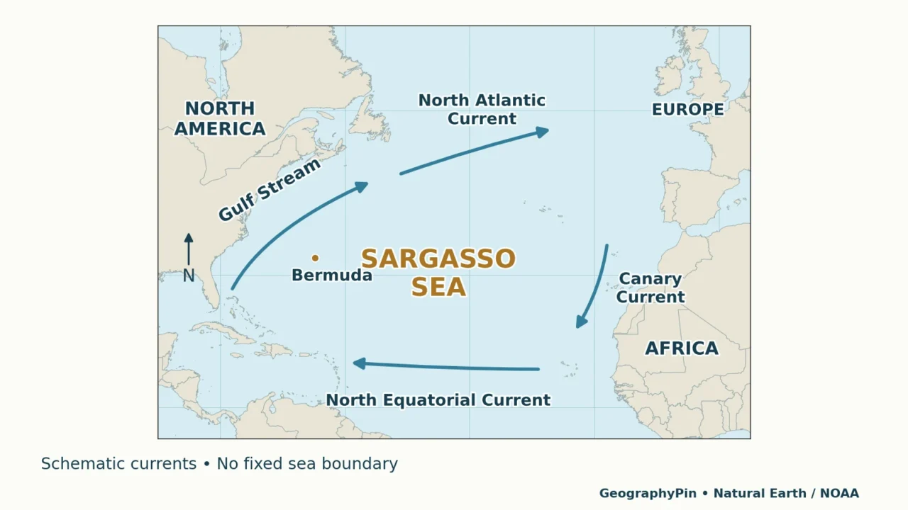
The Sargasso Sea is an open-ocean region within the North Atlantic subtropical gyre, defined by circulating currents rather than an enclosing coastline. It is named for floating Sargassum seaweed that supports a distinctive habitat. Its edges shift with ocean conditions, so a schematic map is a guide to its setting, not a permanent surveyed boundary.
- Wondering how a sea can have no land shores? Start with Bermuda and the open-ocean setting.
- Comparing different maps? Read natural edges versus a study area.
- Reading about seaweed on a beach? See the sea, the tropical belt and coastal arrivals.
1. Where Is the Sargasso Sea?
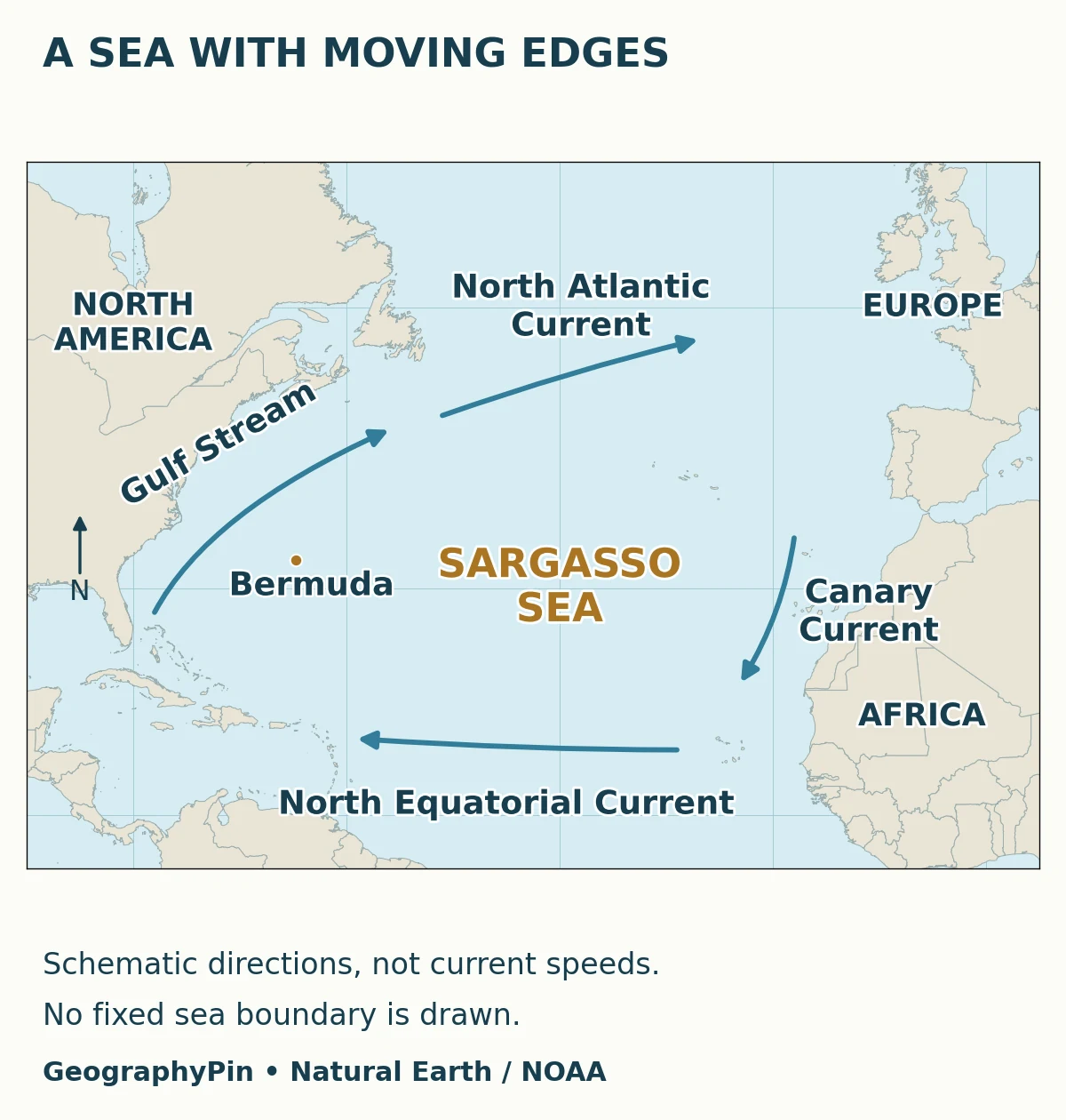
Bermuda is within the region, not its enclosing shore
The Sargasso Sea occupies part of the western and central North Atlantic, east of North America and north of the tropical Atlantic. It is a region within the Atlantic Ocean, not another ocean and not a landlocked water body.
Bermuda provides a useful geographic reference. The islands lie within the Sargasso Sea, as the Hamilton Declaration recognizes. Saying that the sea has no land boundary does not mean that no island exists inside it. It means that surrounding coasts do not define its outer edge.
That makes it unlike a sea partly enclosed by continents or peninsulas. Here, the surrounding circulation gives the region its broad geographic identity. There is no continuous beach to follow around its perimeter.
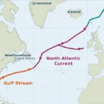
The map places the name inside the current system without drawing a rigid outline. Its arrows are deliberately schematic. They show the broad circulation pattern, not the position of a particular front today, the path of an individual piece of seaweed or a navigational route.
2. The North Atlantic Gyre and Its Currents
A gyre is a large system of rotating ocean circulation. The North Atlantic subtropical gyre circulates broadly clockwise. Wind helps drive large-scale surface flow, while Earth’s rotation and the shape of the ocean basin help organize it. The result is more complicated than water traveling around one circular track.
NOAA’s overview identifies four named currents that provide the familiar geographic framework:
| Current | Broad side of the system | General direction shown |
|---|---|---|
| Gulf Stream | Western | Northward and then northeastward |
| North Atlantic Current | Northern | Generally eastward and northeastward |
| Canary Current | Eastern | Generally southward |
| North Equatorial Current | Southern | Westward |
These are broad labels, not four solid walls. Currents meander, branch and interact with eddies. The Canary Current is relatively diffuse, making a simple eastern edge especially difficult to define. The sea is not a sealed reservoir: water and floating material can move through the wider circulation system.
Nor is the interior motionless just because a teaching map shows its strongest arrows around the outside. A sparse map leaves out smaller and changing movements. For the underlying processes, see how ocean currents work.
3. Why Its Boundaries and Area Are Not Fixed
An operational outline answers a different question
A natural region can be recognizable without having a single permanently agreed perimeter. A current-based definition, a map of seaweed observations and an area chosen for coordinated conservation need not produce identical outlines.
In their 2011 report Where Is the Sargasso Sea?, Ardron and colleagues developed an operational study area for the Sargasso Sea Alliance. Their work combined oceanographic and biological considerations with practical jurisdictional choices. The report explicitly distinguished that working area from fully resolving the sea’s natural extent.
The distinction matters when reading an authoritative-looking polygon. A clearly drawn line can be useful for organizing research or collaboration without becoming a physical barrier in the water. A high-resolution outline is not automatically a more exact description of a changing ecosystem.
How large is it?
The Sargasso Sea Commission describes the ecosystem as roughly 2 million sq mi (5.2 million km²). Treat that as a broad scale description, not a current measurement of a fixed shape. A numerical area for a particular study or collaboration polygon describes that chosen polygon and may differ.
When comparing figures, ask what was outlined, why that boundary was selected and whether the figure refers to the sea, a study area or observed seaweed coverage. Those are three different measurements. The shaded area of a seaweed-detection image should not be substituted for the size of the sea itself.
4. Sargassum: A Floating Habitat
Sargassum is a group of brown algae. Some species attach to the seabed, but the familiar pelagic forms associated with this sea spend their lives floating. Two important Atlantic species are Sargassum natans and Sargassum fluitans. The whole genus should not be described as exclusively free-floating.
Small gas-filled structures help the algae remain buoyant. Floating branches form a three-dimensional habitat that offers food and refuge for animals such as small fishes, crabs and shrimp. Young sea turtles also use this habitat. The conceptual diagram shows that relationship rather than a complete food web or the relative size of each organism.
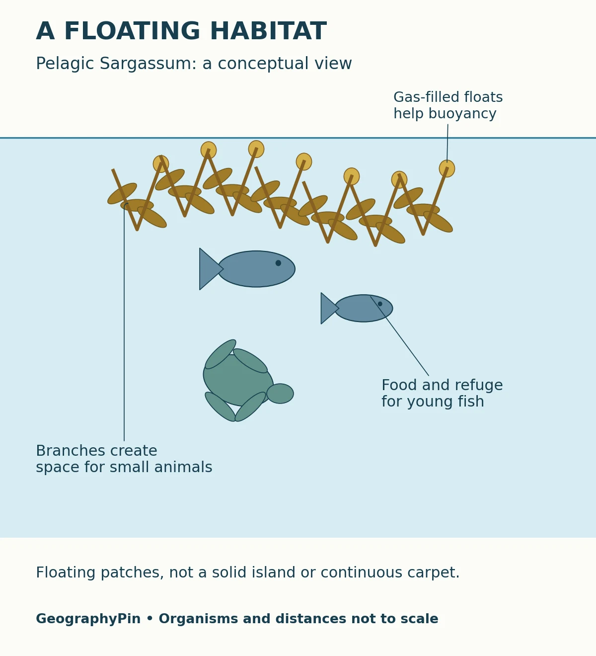
At the surface, Sargassum occurs in clumps, patches, rafts and lines. It is not one solid island, and the entire Sargasso Sea is not continuously covered by an unbroken mat. The name identifies a characteristic ecosystem, not a guarantee of identical seaweed density everywhere.
The ecological value also extends beyond the algae visible in a photograph. The Commission highlights the region’s importance to migratory animals and the breeding cycle of Atlantic anguillid eels. That is a regional ecological relationship, not a claim that every animal lives inside a floating raft.
A useful way to read the habitat is to separate its structure from its inhabitants. Branching algae provide the physical setting; different animals use it in different ways and at different life stages. A nursery habitat is especially important to young animals even when the adults spend much of their lives elsewhere.
5. Why Beach Blooms Are a Different Question
The sea, the tropical belt and a coastal arrival
News about large Sargassum arrivals in the Caribbean is not simply a report that the Sargasso Sea has reached a beach. EPA distinguishes the Great Atlantic Sargassum Belt, a recurring tropical Atlantic aggregation observed since 2011, from the traditional Sargasso Sea farther north.
Wang and colleagues’ 2019 study identified the recurrent belt in satellite imagery. Its distribution is strongly influenced by ocean circulation. That is a different geographic feature from the current-defined subtropical sea, even though both contain pelagic Sargassum.
Keep three questions separate:
- Sargasso Sea: where is this North Atlantic oceanographic and ecological region?
- Sargassum belt: where is a large tropical aggregation present during a given period?
- Beach inundation: will winds, currents and local conditions deliver large amounts to a particular shore?
Offshore habitat can be valuable while excessive coastal accumulation causes problems. NOAA describes how stranded material can affect coastal ecosystems, infrastructure and tourism. Decomposition can also release hydrogen sulfide. That contrast is about quantity, location and condition, not a contradiction about whether all seaweed is “good” or “bad.”
A general map cannot predict the condition of a beach on a travel date. Use current regional monitoring and local advisories for that purpose. An old satellite image may illustrate a bloom, but its date matters: it is not evidence that the same mass is present now.
6. Reading the Sea as an Ecosystem
The Sargasso Sea joins physical geography with ecology. Currents organize a broad setting; floating habitat supplies food and shelter; animals move through the region. None of these layers is adequately described by a single permanent outline.
Before trusting a map, check its purpose. Does it show general circulation, a defined collaboration area or satellite-detected algae? Then check its date and legend. Arrow width may encode a measured quantity on one map and be purely illustrative on another. In the original map here, arrows show direction only.
Conservation adds another layer. The 2014 Hamilton Declaration established a collaborative framework and explicitly states that the declaration itself is not legally binding. It recognizes that most of the ecosystem lies beyond national jurisdiction. A conservation collaboration area should therefore not be mistaken for a single uniform no-use reserve.
These distinctions make the sea more understandable, not less real. Geographic regions can have shifting edges, and practical research boundaries can still be useful. The key is to say which kind of boundary a map represents instead of allowing a precise-looking line to imply more certainty than the evidence supports.
Frequently Asked Questions
Are the small round floats on Sargassum berries?
No. The berry-like structures are gas-filled floats, called pneumatocysts. They help buoyancy; they are not fruits on a flowering plant.
Does floating Sargassum stay at the surface forever?
No. Material that loses buoyancy can sink, carrying organic matter into deeper water. A surface habitat is therefore connected with processes below it, rather than being permanently isolated at the top of the ocean.
What Did We Learn Today?
The Sargasso Sea is a current-defined North Atlantic region, not a basin enclosed by land or a continuous seaweed island. Its moving natural edges differ from operational study areas, and its floating habitat is distinct from the tropical Sargassum belt and individual beach arrivals. Reading the purpose, date and limits of each map is essential to understanding the sea accurately.
Sources & Data Notes
- NOAA National Ocean Service: What is the Sargasso Sea? Current framework and dynamic boundaries.
- NOAA: Ocean currents. Broad circulation drivers.
- Sargasso Sea Commission overview. Ecosystem scale and ecological importance.
- Ardron and colleagues, 2011: Where Is the Sargasso Sea? Operational delineation and its limitations.
- Hamilton Declaration, 2014. Bermuda, collaboration and jurisdictional context.
- NOAA Ocean Exploration: What is Sargassum? Buoyancy, habitat and sinking material.
- EPA: Basic information on Sargassum and Great Atlantic Sargassum Belt. Species and geographic distinctions.
- Wang and colleagues, 2019. Satellite evidence for the tropical belt; abstract available through the University of South Florida.
- NOAA: Sargassum from sea to shore. Coastal effects and links to monitoring tools.
Visual methods: original GeographyPin map and conceptual habitat diagram. The map uses public-domain Natural Earth land and location data. Current arrows are generalized teaching symbols, not measured tracks, speeds, legal limits or a forecast. No fixed Sargasso Sea polygon or measured seaweed coverage is shown. Organisms in the habitat diagram are illustrative and not to scale. The approximate area conversion is rounded; it is not a newly calculated boundary measurement.