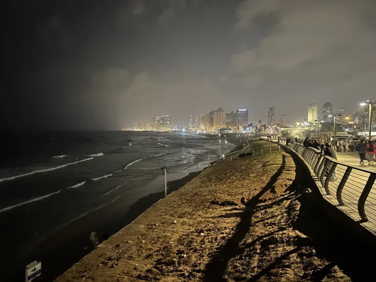
Israel lies on the eastern Mediterranean, where a coastal plain gives way to hills, inland depressions and the dry Negev. These landscapes change over short distances, so neither a beach scene nor a desert image represents the whole country. Reading the physical map also requires separating landforms from disputed territorial boundaries and the wider coverage used in some official statistics.
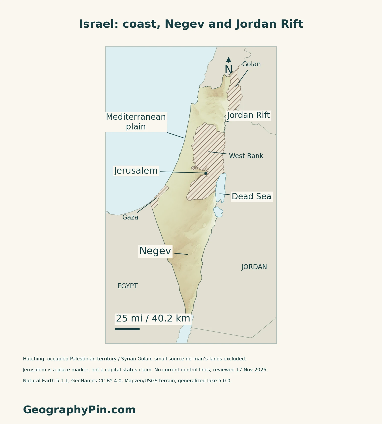
The Mediterranean coastal plain is low and maritime, while hill country rises inland. Farther east, the Jordan Rift contains deep depressions, including the Dead Sea basin. The Negev forms an arid southern landscape of rocky uplands, valleys and erosional landforms. These physical regions do not define sovereign borders.
How to use this article: Locate the country, compare the physical settings, or follow Dead Sea setting.
1. Locate the Country and Read the Map’s Scope
An Eastern Mediterranean Setting
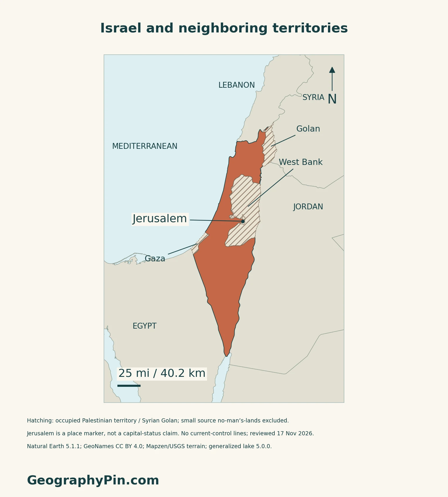
Israel faces the Mediterranean, with Lebanon to the north, Egypt to the southwest and Jordan to the east. Syria lies to the northeast.
Geography Is Not a Territorial Claim
The West Bank, including East Jerusalem, and the Gaza Strip are occupied Palestinian territory; the Golan Heights is occupied Syrian territory. They are not silently included in the highlighted national area on these maps. A city label locates Jerusalem without settling the city’s status.
The Middle East regional guide provides wider context. The separate Jerusalem guide examines capital law, institutions and recognition in more detail.
2. Compare the Coast, Hill Country, Rift and Negev
Four Contrasting Landscape Settings
| Setting | Geographic distinction |
|---|---|
| Mediterranean plain | Low ground beside the Mediterranean. |
| Northern and central hill country | The central ridge continues through the occupied West Bank. |
| Jordan Rift | Inland depression including the Dead Sea basin. |
| Negev | Rocky southern desert, not only sand. |
Why Ramon’s “Crater” Is Different
Makhtesh Ramon illustrates the Negev’s geological variety. A 2023 field and modeling study describes it as an erosional landform developed in folded rock, rather than a meteorite-impact crater or a volcanic crater. Harder rock above more erodible layers helped produce its cliffs and interior.
The study also links variations along the escarpment with intense, short-duration rainstorms. Arid terrain can be actively shaped by water even when its channels are dry much of the time.
3. Distinguish the Dead Sea From the Coast
An Inland Basin Below Sea Level
The Dead Sea is an inland closed basin, not an inlet of the Mediterranean. USGS satellite comparisons distinguish its natural northern lake from the managed evaporation ponds farther south. The western shoreline includes both Israel and the West Bank, while Jordan lies to the east.
USGS connects the long-term decline with reduced tributary inflow and industrial water use. Its image sequence is historical evidence of change, not a measurement of the shoreline on the day you read this page. The dedicated Dead Sea guide covers the lake’s salinity, changing water level and basin distinction.
A Reference Map Is Not a Current Shoreline Survey
Below-sea-level terrain is a real feature of this landscape. Our relief map retains valid negative elevations, but its generalized water references and source terrain should not be used to infer today’s exact waterline, exposed shore or access conditions.
4. Connect Climate With Water Supply
Mediterranean Seasons and a Desert Transition
CBS’s climate definitions describe hot, dry summers and cooler, rainy winters, with desert conditions in the south and east. Rainfall varies substantially between places and years. A national average therefore hides important differences between the coastal and hill regions and the Negev.
Natural Resources and Engineered Supply
Israel’s environmental ministry’s 2025 report to the UN climate convention distinguishes surface freshwater, groundwater aquifers, desalinated seawater and treated wastewater. It describes desalination and wastewater recovery as responses to natural water scarcity.
These sources have different roles: a rainfall map is not a complete map of water supply. The report is used here for the types of infrastructure and resources, not to claim that every facility is operating now or that water access is uniform across Israel and the occupied territories.
5. Check Dated Country Facts
| Item | Reference |
|---|---|
| Capital reference | Jerusalem, designated by Israeli Basic Laws; international status qualified below |
| Population reference | About 10.305 million; provisional CBS estimate for the eve of Rosh Hashanah 2026, released September 9, 2026 |
| Area reference | About 8,522 sq mi (22,072 km²); CBS statistical convention, including East Jerusalem and the Golan Heights |
| Currency | New Israeli shekel (NIS) |
| Languages | Hebrew is the state language; Arabic has special status under the 2018 Basic Law |
| District reference | Six in the CBS administrative scheme: Jerusalem, Northern, Haifa, Central, Tel Aviv and Southern |
Statistical coverage is not a border
The provisional population estimate is based on the 2022 census and includes foreigners; it is not a new census count. CBS coverage includes East Jerusalem residents, the Golan population and residents of Israeli settlements in the West Bank, not the whole Palestinian population of the West Bank and Gaza. Its area convention includes land and inland waters, but does not add the entire West Bank or Gaza. These statistical definitions do not establish sovereignty.
Jerusalem and occupied territories
Israeli law designates Jerusalem as the capital and seat of national institutions. Security Council Resolution 478 rejects the unilateral changes to Jerusalem’s status embodied in the 1980 Basic Law. The UN identifies East Jerusalem as occupied Palestinian territory and the Golan Heights as occupied Syrian territory; Resolution 497 rejects Israel’s imposition of its laws on the Golan. Those territories must not be silently treated as sovereign Israeli territory because they appear in Israeli statistics.
Language provisions
The 2018 Basic Law gives Hebrew state-language status and Arabic special status. It also preserves the status Arabic had in practice before the law took effect; “special status” should not be paraphrased as an absence of language rights.
For a broader comparison, see the Asian countries and capitals reference.
What Did We Learn Today?
Physical continuity does not settle sovereignty, and an official statistical total must be read with its territorial and population definitions.
Sources & Data Notes
Sources, dates and map conventions
The September 2026 CBS release labels its population estimate provisional and census-based, with foreigners included. Older CBS population definitions excluding foreign workers are not applied to this estimate. Area follows the explicitly attributed CBS convention rather than the map’s territorial highlighting or a current lake-shore measurement. Knesset English translations identify their consolidation date as May 1, 2022; the cited capital and language clauses were read directly. Security Council resolutions 478 and 497 provide the cited international legal context. UN General Assembly Resolution 80/81 supplies additional explicit occupied-territory terminology. The 2018 MFA booklet supports physical descriptions only; its territorial presentation, old statistics and sweeping river-direction claims are not adopted. Climate context comes from CBS’s 2023 definitions; no old climatic-normal values are presented as new observations. The 2023 Ramon study supports geological processes, not visitor safety. USGS Earthshots supports the Dead Sea basin distinction and historical change, not present shoreline or water level. The environmental ministry’s 2025 UNFCCC report supports water-resource types only; its numerical water-level and infrastructure claims are not repeated. No source imagery is reused. Territory, administrative statistics and physical landforms have distinct scopes.
- CBS: September 9, 2026 provisional population and attributed area reference
- CBS: census-based district table and territorial coverage, published January 2025
- CBS: historical population geography definitions; superseded foreign-worker exclusions not used
- CBS: area convention including East Jerusalem and the Golan
- CBS: six-district land-and-lakes area inventory
- CBS: October 2026 publication corroborating the six district names
- Knesset: 2018 Nation-State Basic Law, Articles 2–4; English translation through May 2022
- Knesset: Jerusalem Basic Law, Articles 1–2; English translation through May 2022
- UN Security Council: Resolution 478 (1980), Jerusalem
- UN Security Council: Resolution 497 (1981), occupied Syrian Golan
- UN General Assembly: Resolution 80/81 (2025), occupied territories and distinction
- Bank of Israel: new shekel currency
- International Court of Justice: July 19, 2024 advisory opinion, territorial scope paragraphs 78 and 94
- Ministry of Foreign Affairs: The Land, 2018, physical descriptions only
- CBS: 2023 definitions, climate section
- Shmilovitz and colleagues, 2023: rainstorms and the Ramon escarpment
- USGS Earthshots: Dead Sea, Israel, Jordan and West Bank
- Israel environmental ministry: 2025 report submitted to UNFCCC
Original maps: Natural Earth public-domain countries and disputed areas 5.1.1, lakes 5.0.0; GeoNames CC BY 4.0 place coordinates; Mapzen/USGS terrain. The highlighted outline and cover exclude source polygons for the West Bank, East Jerusalem, Gaza, Syrian Golan and two no-man’s-lands. Hatching distinguishes these areas; it does not map present control. This territorial distinction follows UN General Assembly resolution 80/81, not a new boundary survey. Status reviewed November 17, 2026; source geography is older. Jerusalem’s point does not imply recognition of capital status. Regional labels are approximate references. Generalized lake geometry is not current water extent. Terrain retains negative values, including below-sea-level areas and possible coastal/water samples; it is qualitative, not a surveyed elevation or bathymetric map. The flag rendition comes from Flagpedia, which permits free reuse; clipping is decorative, while the separate flag is complete.