On a map of Canada, Hudson Bay looks almost like a hole in the continent. Yet its ocean connections, far-reaching river network and winter ice make it very different from an enormous freshwater lake. Understanding it starts with separating the bay itself from James Bay, Hudson Strait and the much larger land area that drains toward these waters.
Hudson Bay is a large marine bay in northeastern Canada, connected to the Labrador Sea and North Atlantic through Hudson Strait. James Bay extends south from it. Rivers deliver freshwater from a vast inland drainage network, while sea ice forms and melts seasonally. The bay’s water surface, its watershed and its ice-monitoring region are different geographic areas.
1. Where is Hudson Bay?
Hudson Bay reaches deep into northeastern North America. Nunavut borders its western and northern mainland shores; Manitoba lies to the southwest, Ontario to the south, and Quebec to the east. Its southern extension, James Bay, reaches between Ontario and Quebec.
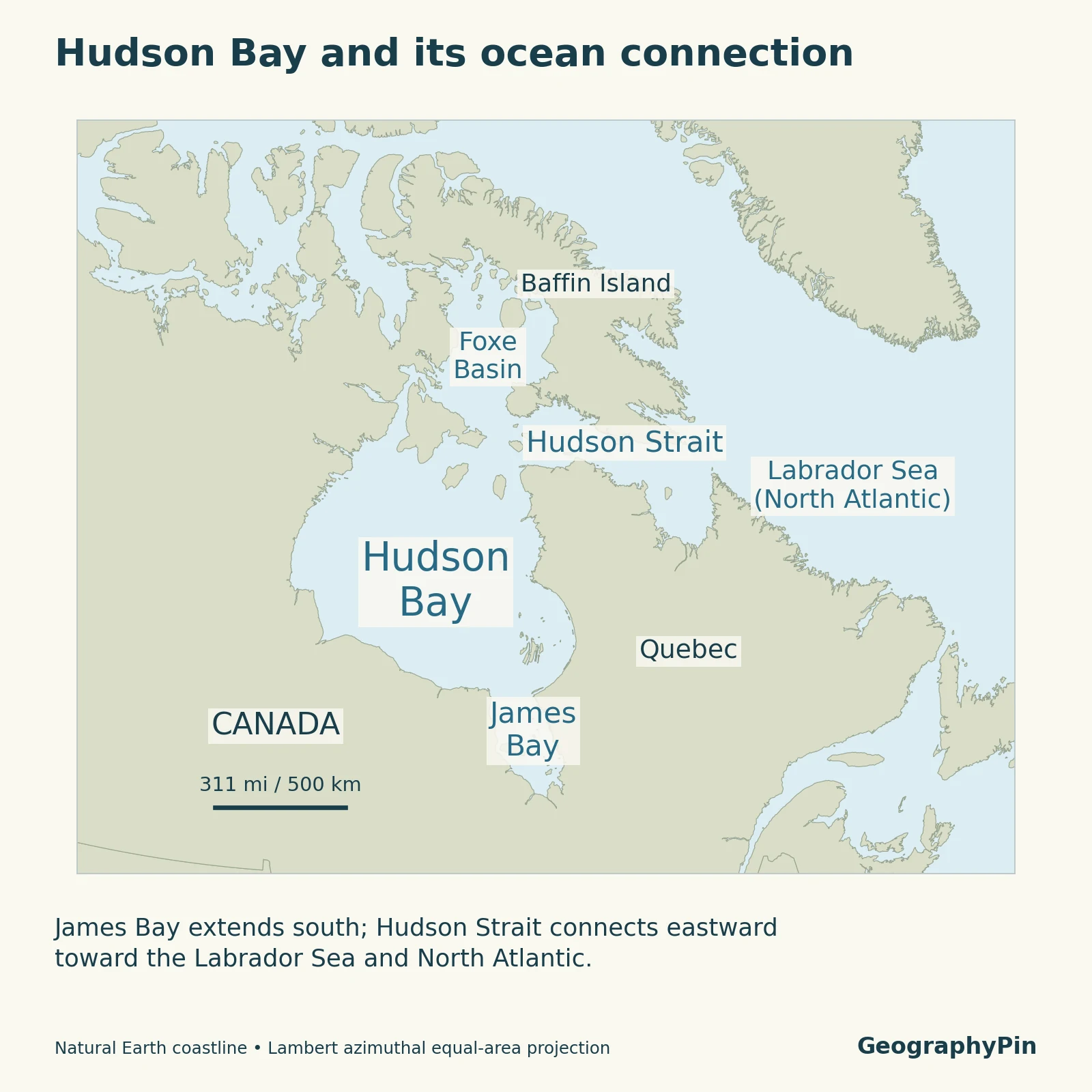
The broad outline is only the beginning. Near its northeastern entrance, islands and passages connect the main bay with Hudson Strait and Foxe Basin. A map that labels every surrounding water body simply “Hudson Bay” hides the routes through which water and ice move.
The Canadian Hydrographic Service’s northern geography overview describes the bay as an inland sea. Here, “inland” describes how far it penetrates the continent, not isolation from the ocean.
2. Hudson Strait and the ocean connection
Hudson Strait is the main Atlantic gateway
Hudson Strait runs between northern Quebec and Baffin Island toward the Labrador Sea. It is the principal connection between the Hudson Bay system and the North Atlantic. Farther north, Foxe Basin and Fury and Hecla Strait provide another connection toward Arctic waters, so Hudson Strait is not the system’s only marine passage.
These are connected seas and channels, not a river flowing from a lake to the coast. Water exchange involves currents, tides, winds and differences in water properties. The Arctic Council’s Hudson Bay Complex overview treats Hudson Strait, Foxe Basin and the bay as parts of a wider marine setting.
Freshwater influence does not make it a freshwater lake
River runoff and melting sea ice freshen the marine water. Their effects vary through the year and across the bay, especially near river mouths. Research describes Hudson Bay as a large subarctic estuarine system: freshwater input interacts with ocean water rather than replacing it.
A 2020 study of basin-scale circulation explains how river input, the annual ice cycle and winds contribute to seasonal water transport. A single salinity number would conceal much of this variation.
3. James Bay and the surrounding coasts
James Bay is the southern extension of Hudson Bay, not an alternative name for the entire bay. Hudson Strait is its northeastern ocean connection, while Foxe Basin lies farther north. Those distinctions matter when comparing maps, ice reports or measurements.
Rocky shores and lowland wetlands
The surrounding land is not uniform. Much of the region belongs to the Canadian Shield, where exposed ancient bedrock shapes uneven terrain. Along the southern and southwestern margins, the Hudson Bay Lowlands form a contrasting landscape of low relief, wetlands and peatlands.
The last ice sheet pressed down the land beneath its enormous weight. After the ice retreated, the crust began recovering. This continuing process, called glacial isostatic adjustment, helps explain raised former shorelines around the bay.
NASA’s Landsat observations of the Ontario coast show sequences of abandoned beaches inland from the modern shore. The ridges record changing relative sea level as land rose; they are not evidence that every coast is changing at an identical rate.
Farther south, astronaut photography of the James Bay Lowlands reveals river channels crossing peatlands and faint beach ridges near the coast. This is a useful example of how geology, water and vegetation combine in physical geography.
4. Watershed and freshwater input
The drainage map covers more than the bay’s shoreline
A watershed is the land area whose runoff reaches a particular outlet or connected receiving waters. Hudson Bay’s freshwater supply begins far beyond its coastal lowlands, including rivers that cross the Canadian Prairies.
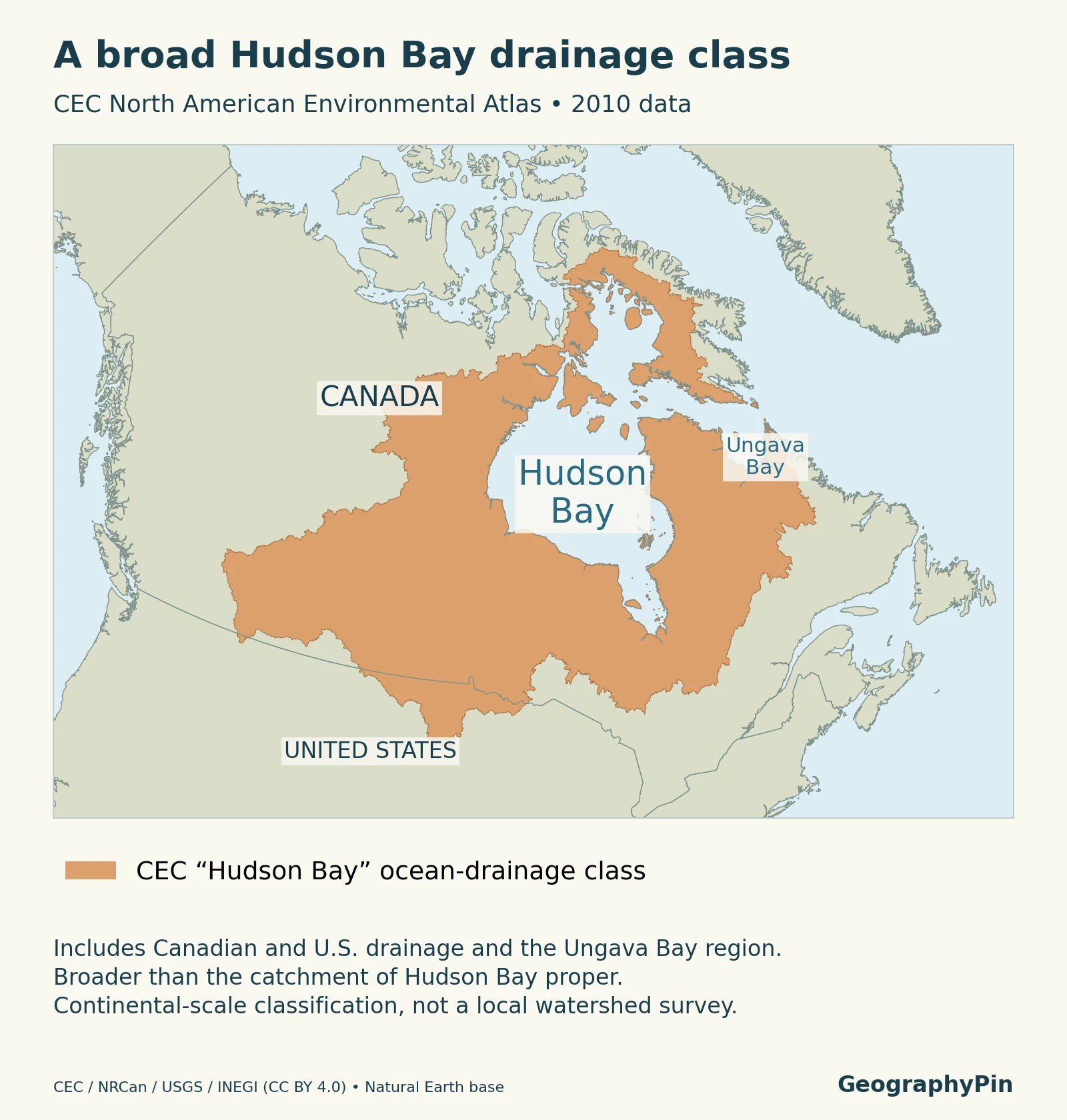
The shaded map follows the Commission for Environmental Cooperation’s 2010 Hudson Bay ocean-drainage class. This broad classification includes drainage toward James Bay and Ungava Bay as well as Hudson Bay. Ungava Bay opens into Hudson Strait, so not all shaded land drains directly into the main bay. The layer also includes contributing land in the United States.
This distinction prevents a common error: treating the outline of a named drainage region as the outline of the water body itself. Nor should an area quoted for another watershed definition automatically be attached to this particular overlay.
Follow one river network from the interior
The Nelson system gives the map a practical meaning. Water from the Saskatchewan, Red and Winnipeg river systems reaches Lake Winnipeg; the Nelson River then carries water toward Hudson Bay. Manitoba’s water-resources overview also identifies the separate Churchill, Seal and Hayes river systems.
River contributions change with snowmelt, rain and storage in lakes and wetlands. Dams, diversions and other water-management works can modify the timing of flows. A drainage map shows geographic connections, not how much water each river supplies on a particular day.
5. Seasonal sea ice
A seasonal cycle, not one bay-wide freeze date
The Canadian Ice Service’s 1991–2020 climate normals describe a broad progression: freeze-up spreads from northwest toward southeast, while melting generally advances from the shores toward the central ice pack.
That pattern is not a calendar guarantee. Winds move and compress ice; currents can maintain openings; coastal fast ice behaves differently from mobile offshore ice. Occasional older ice can enter the northeastern bay from Foxe Basin. The distinction between newly formed ice and older ice is explained in how sea ice forms. “Seasonally ice-covered” therefore does not mean every location freezes or clears simultaneously.
Long-term change is a separate question from this annual cycle. ECCC’s 1968–2024 sea-ice indicator reports a declining summer ice-area trend for its Hudson Bay sub-region. Its broader “Hudson Bay domain” also includes Hudson Strait, Davis Strait and the northern Labrador Sea; figures for that domain are not figures for the bay alone.
For conditions now, use the Canadian Ice Service’s current charts. A climate normal describes a historical pattern, not safe travel, ice thickness at a particular location or an open shipping route.
6. Key facts and measurement notes
| Item | What it means |
|---|---|
| Water body | Marine bay in northeastern Canada, with James Bay extending south. |
| Approximate surface area | About 460,000 square miles (1.2 million km²), explicitly including James Bay in Kazmiruk and colleagues’ 2021 study. |
| Main Atlantic connection | Hudson Strait leads toward the Labrador Sea. |
| Drainage overlay | CEC’s 2010 Hudson Bay ocean-drainage class; broader than land draining directly into the main bay. |
| Ice baseline | Canadian Ice Service climate normals for 1991–2020, not today’s ice conditions. |
The surface-area estimate is deliberately rounded. It is a water-surface figure, not the much larger watershed area. Definitions that include additional waters, such as Foxe Basin or Hudson Strait, describe a different geographic unit.
Common questions
Is the Hudson Bay Lowland the same as the Hudson Bay watershed?
No. The lowland is a physical landscape near the bay, while the watershed is defined by drainage. The wider river network reaches well beyond that lowland into other landform regions.
What Did We Learn Today?
Hudson Bay links inland drainage with a seasonally ice-covered marine environment. James Bay, Hudson Strait and Foxe Basin have distinct positions in that system. The most useful maps keep three things separate: the water surface, the land contributing runoff and the region used for ice statistics.
Sources & Data Notes
Area comparisons retain each source’s geographic definition. Ice normals and long-term observations are historical datasets, not a forecast. The maps explain geography rather than navigation or local ice safety.
Map method: Geographic context uses Natural Earth public-domain data. The drainage map selects the Hudson Bay ocean-drainage class from the CEC North American Environmental Atlas, 2010, using the original polygons rather than a hand-drawn outline. Data credit: CEC, Natural Resources Canada, USGS and INEGI, reused under CC BY 4.0. This continental-scale classification includes U.S. and Ungava Bay drainage; it is not a detailed current catchment survey. Inland water is included within its drainage units. No catchment area was calculated from these shapes.
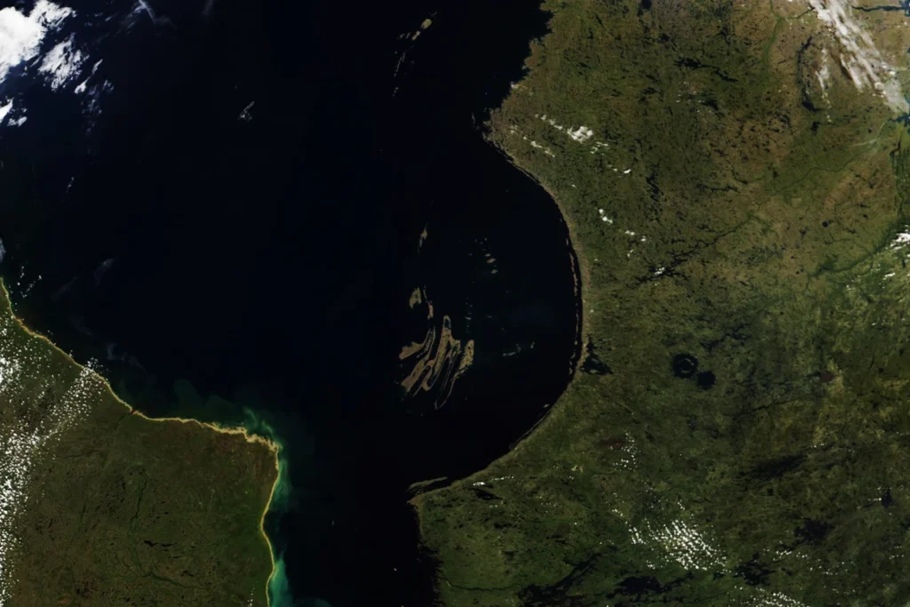
Featured satellite image: Southeastern Hudson Bay and the Nastapoka Arc, August 16, 2022. NASA Earth Observatory image by Lauren Dauphin, using VIIRS data from NASA EOSDIS LANCE, GIBS/Worldview and JPSS. Resized and converted from the original; reused with acknowledgment under NASA’s media guidance. It shows part of the bay, not current conditions across the entire region.
- Canadian Hydrographic Service: ARC 400 (2026): Hudson Bay setting, coastal jurisdictions and waterways.
- Arctic Council PAME: Hudson Bay Complex: Marine connections and regional context.
- Ridenour and colleagues (2020): Wind, freshwater and marine circulation.
- NASA: Rebounding in Hudson Bay: Raised beaches and coastal land adjustment.
- NASA: Contours of the James Bay Lowlands: Lowland morphology and peatland setting.
- CEC: North American watersheds: Source classification for the drainage overlay.
- Manitoba: Water Resources Management (2021): Nelson drainage connections and modified river flows.
- Canadian Ice Service: 1991–2020 normals: Regional freeze-up and melt patterns.
- ECCC: Sea ice in Canada: 1968–2024 observations and monitoring-region definitions.
- Kazmiruk and colleagues (2021): Approximate water-surface area explicitly including James Bay.