Polar oceans freeze into an evolving mixture of crystals, slushy patches, pancakes, and older floes. Heat loss, water movement, and the fate of salt explain how these different forms develop.
Sea ice forms when seawater cools to its salinity-dependent freezing point. Small crystals can gather into grease ice, thin sheets, or pancakes, which develop into a connected cover. Growing ice rejects much of the salt into surrounding water, but some salty brine remains trapped inside. Further freezing can thicken the ice from below.
How to use this article: Check why cold air is not enough, compare calm and rough-water formation, or follow what happens to the salt.
1. Seawater must reach its own freezing point
Fresh water freezes at 32°F (0°C) under ordinary surface conditions. Dissolved salt lowers the freezing point, so seawater can remain liquid below that temperature. Around 28.8°F (−1.8°C) is a useful example for polar seawater, not a universal threshold for every bay or ocean.
The water temperature matters, not just the air
A freezing-weather forecast does not mean the ocean immediately freezes. The water must lose enough heat, and warmer water mixed upward can delay the process. The Canadian Coast Guard: Ice Climatology and Environmental Conditions distinguishes the onset of cold air from the later formation of sea ice.
Salinity helps explain why the threshold varies. Fresher water near river inflows need not freeze at exactly the same temperature as saltier offshore water. NOAA JetStream: Sea Water describes the connection between salt concentration and freezing temperature.
There is also a difference between starting ice crystals and building a durable cover. A thin patch may form, drift, break up, or melt before the surrounding water freezes. Sea ice is a changing material within a moving ocean, not a lid that appears everywhere at once.
2. From tiny crystals to a connected ice cover
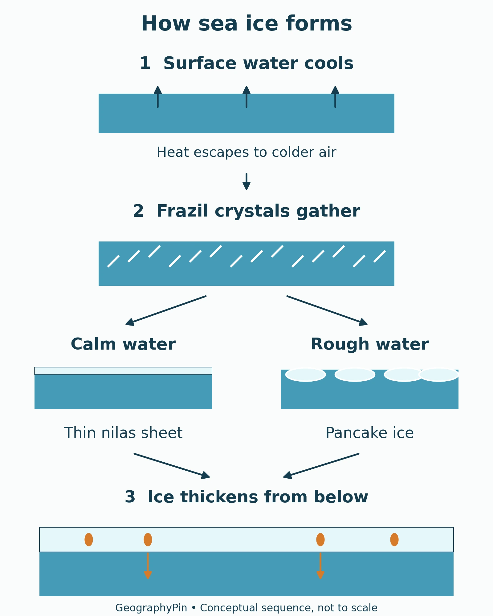
A common beginning is frazil: small ice crystals suspended in the water. As they accumulate, they can produce a soupy surface layer called grease ice. The name describes its appearance; it is ice and water, not oil.
Calm water and rough water take different paths
In relatively calm conditions, the crystals can join into a thin, flexible sheet called nilas. In rougher water, wave action helps organize the accumulating ice into rounded pieces called pancake ice. Collisions can build raised rims around the pancakes, which may eventually freeze together. Met Office: Sea Ice Overview describes these contrasting pathways.
Once an ice cover has consolidated, additional seawater can freeze onto its underside. That bottom growth is called congelation. It is different from loose crystals gathering at the surface, even though both processes add frozen water to the ice cover. NSIDC: Science of Sea Ice describes both mechanisms.
3. Where the salt goes as sea ice grows
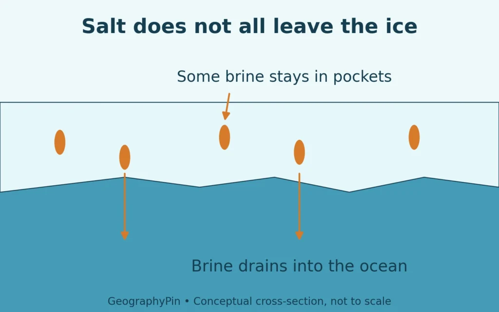
The growing ice crystal structure largely excludes dissolved salt. That does not make a newly formed piece of sea ice completely fresh. Some very salty liquid, called brine, remains between the crystals in pockets and channels.
Ice crystals and trapped brine are different
Think of the material as two parts: relatively fresh solid ice and salty liquid trapped inside it. Brine rejection moves salt into the surrounding water, while retained brine gives the bulk sea ice a salt content of its own. A salt-budget illustration therefore needs both pathways, not an arrow suggesting that every bit of salt immediately leaves.
Brine can drain through the ice. Meltwater can also flush it during warmer periods. Older ice generally contains less salt than newly formed ice, but age alone is not a laboratory measurement of salinity.
The Environment and Climate Change Canada: Sea Ice Growth explains that brine trapped between crystals can remain liquid at low temperatures. It also notes that rapid freezing can trap more brine than slow freezing. The result depends on formation conditions, not just whether an ice sample came from the sea.
Salt released during freezing increases the salinity of nearby water and can increase its density. This contributes to ocean circulation, but it does not mean every patch of new ice sends a plume directly to the deepest ocean. The World Meteorological Organization: Sea Ice describes brine rejection as one contributor to dense-water formation.
4. Ice thickens by freezing and by being pushed together
For bottom freezing to continue, heat must leave the water through the ice above it. A thicker ice cover offers more resistance to that heat flow. Snow adds insulation too, so equally cold air can produce different growth rates over bare ice and snow-covered ice.
Ice does not have one universal overnight growth rate. Its starting thickness, snow cover, water conditions, and the temperature difference determine how efficiently heat can escape.
Freezing is not the only way to make a thick patch. Thin floes can slide over one another, a process called rafting. Stronger compression can fracture and pile ice into pressure ridges. The Met Office: Sea Ice Overview separates these mechanical changes from growth caused by freezing.
A pressure ridge can contain stacked and broken ice rather than one thick layer formed by freezing. Surface appearance alone does not reveal its entire structure.
5. First-year ice, older ice and the polar setting
First-year ice forms during the current growth season and has not yet survived a summer melt. Ice that persists through summer enters an older age class. Broad scientific explanations commonly call ice that has survived a summer “multiyear ice”; detailed ice-chart terminology can separate second-year ice from older multiyear ice.
This distinction matters when comparing a simplified explanation with a navigation chart. The Canadian Coast Guard: Ice Climatology and Environmental Conditions uses “old ice” for the broader category and subdivides it when its history is known. Age, thickness, and shape are related, but they are not interchangeable labels.
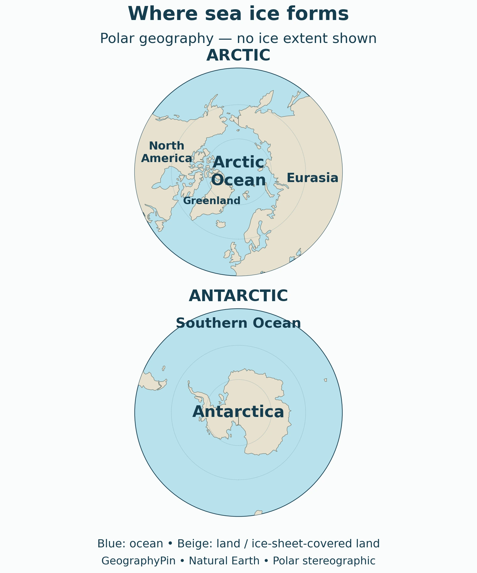
The Arctic is an ocean-centered region surrounded by land. Around Antarctica, sea ice forms in the ocean bordering a continent. Those arrangements create different settings for ice movement and seasonal expansion. The map shows that geographic context, not a measured ice edge.
For the wider comparison, see Arctic versus Antarctica. The archived NOAA Climate.gov archive: Polar Opposites supports the land–ocean distinction; its historical climate statistics are not used here as present-day measurements.
6. Sea ice is not the same thing as an iceberg
| Ice type | How it originates | Why the distinction matters |
|---|---|---|
| Sea ice | Seawater freezes. | It can contain trapped brine and grows within the ocean. |
| Glacier ice | Snow accumulates and is transformed into ice on land. | Its formation is not the freezing of the sea surface. |
| Iceberg | A piece breaks away from a glacier or ice shelf and floats. | Floating in seawater does not make it sea ice. |
The NOAA: What Is an Iceberg? identifies break-off, or calving, as the key event. A photograph of a floating block alone can hide that history. The question to ask is not merely “Is it in the ocean?” but “Did this ice form from seawater, or arrive from a glacier or ice shelf?”
These categories can share the same scene. Sea ice may surround an iceberg, and snow may lie on top of either. Their appearance does not erase the different processes that produced them.
What Did We Learn Today?
Sea-ice formation involves more than reaching a cold air temperature. Water must lose heat, new crystals develop differently in calm and rough conditions, and salt moves between ice and ocean rather than disappearing. Later thickness reflects both freezing and mechanical piling. Keeping origin, age, and shape separate also prevents confusion between sea ice and icebergs.
Sources & Data Notes
The freezing temperature is illustrative, not a fixed threshold for all seawater. Formation graphics are conceptual, not to scale or timed growth forecasts. The polar map shows geography, not current or historical ice extent. Broad age terminology is distinguished from detailed ice-chart classifications. Original diagrams distinguish trapped brine from drainage; their colors do not represent measured salt amounts. The context map uses public-domain Natural Earth land geometry in separate polar stereographic projections, not equal-area views.
- NSIDC: Science of Sea Ice
- NOAA JetStream: Sea Water
- Environment and Climate Change Canada: Sea Ice Growth
- Met Office: Sea Ice Overview
- World Meteorological Organization: Sea Ice
- Canadian Coast Guard: Ice Climatology and Environmental Conditions
- NOAA: What Is an Iceberg?
- NOAA Climate.gov archive: Polar Opposites