Kananaskis Country sounds like one place with one boundary. On a map, it is better understood as a mountain region containing several parks, river valleys, and public-land areas. Separating those layers makes its landscape much easier to read.
Kananaskis Country is a recreational region west and southwest of Calgary in Alberta, Canada, spanning Rocky Mountain and foothill landscapes. It is neither a sovereign country nor one park. Peter Lougheed, Spray Valley, Bow Valley, and Elbow-Sheep Wildland are distinct protected areas within its wider geographical setting.
How to use this article: Compare the named parks, distinguish the boundary types, and check the seasonal-road context.
1. Where is Kananaskis Country?
Kananaskis Country lies west and southwest of Calgary in Alberta, Canada. Its landscape belongs to the eastern Canadian Rockies and their foothills. The name refers to a multi-use recreational region, not an independent country and not a single provincial park.
For the continental setting, see the Rocky Mountains map. Within that much longer mountain system, Kananaskis brings together river valleys, high ridges, lakes, protected areas, and other public lands. “Kananaskis” on a destination label therefore tells you less about local management than a specific park or land-use-zone name.
Alberta Parks: Kananaskis Country information directs visitors to individual parks for detailed information. This is the right scale for understanding a particular lake, trailhead, campground, or valley. A rule attached to one place should not automatically be applied throughout the region.
2. Reading the park mosaic
The map highlights four named protected areas to show how the landscape is divided. Their outlines are park boundaries, not a single enclosing border around Kananaskis Country. Areas without one of these four colors may belong to other parks or public-land designations; unshaded does not mean unprotected.
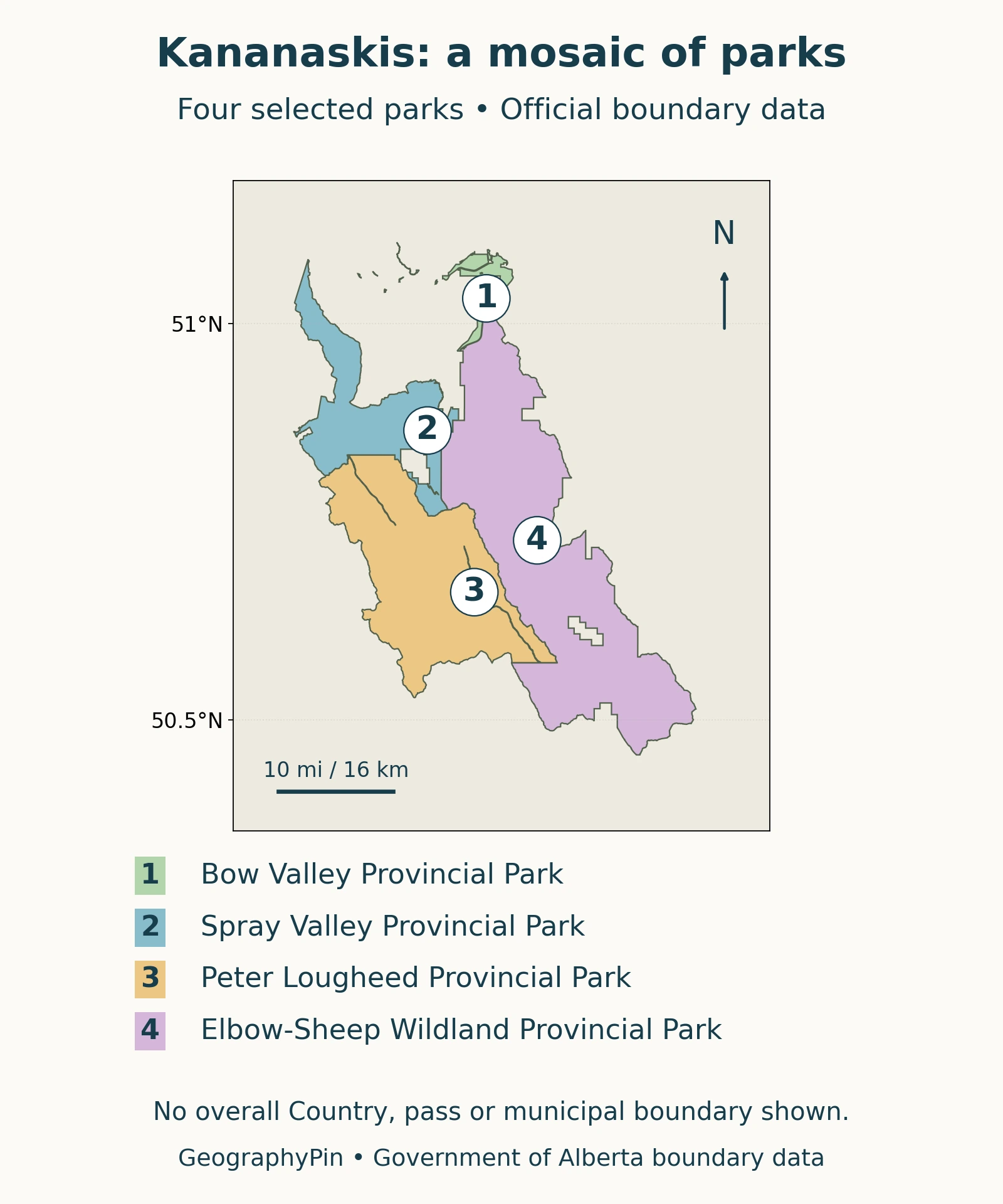
Four parks, different landscapes
| Protected area | Geographic character |
|---|---|
| Bow Valley Provincial Park | The meeting of the Bow and Kananaskis rivers near the front of the mountains. |
| Spray Valley Provincial Park | Mountain slopes and the Spray River valley along Banff National Park’s eastern side. |
| Peter Lougheed Provincial Park | High mountain scenery around Upper and Lower Kananaskis lakes; includes Highwood Pass. |
| Elbow-Sheep Wildland Provincial Park | A mixture of grassy slopes, forest, deep valleys, and mountain peaks. |
These descriptions follow the individual Alberta Parks landscape summaries linked in the source notes. The selection is not a ranking, a complete inventory, or a list of interchangeable visitor experiences.
A pass boundary is not a park boundary
Several different maps can all carry the name Kananaskis. A park map outlines a protected area. A public-land-use map shows a different management unit. A Conservation Pass map identifies where that vehicle-parking requirement applies. These maps answer different questions, so their borders need not match.
The Alberta: Kananaskis Public Land Use Zone is one named land-use zone, not a synonym for the whole recreational region. Similarly, paying for a Conservation Pass does not turn every road or trail into an open route. The appropriate land manager still determines the local conditions and restrictions.
3. Front ranges, foothills, and older rocks
Kananaskis is not simply a collection of isolated peaks. It occupies part of the Canadian Rockies’ mountain belt, where sedimentary layers have been folded and displaced along thrust faults. A thrust fault allows one package of rock to move over another during compression.
The Geological Survey of Canada: Kananaskis west-half geology places the western Kananaskis map area in the Rocky Mountain Thrust and Fold Belt. That regional structure helps explain why a view across the mountains often reveals repeated ridges and inclined rock layers rather than the smooth shape of a single volcanic cone.
The more detailed Geological Survey of Canada: Geology, Kananaskis Lakes shows that the Kananaskis Lakes map area crosses parts of both the Front Ranges and Main Ranges. Its geology includes folded carbonate and clastic rocks. Carbonate rocks include materials such as limestone; clastic rocks form from fragments of older material. Describing every mountain as identical limestone would miss that variety.
Ice later reshaped the terrain. Alberta Parks describes the region’s jagged peaks and U-shaped valleys as features of its glacial landscape. Physical geography distinguishes mountain building from glacial erosion: the first deforms and raises rocks, while the second cuts and modifies the landscape.
The transition eastward is also important. Alberta Parks: Bluerock Wildland describes the Sheep River valley there as a meeting zone between the Rocky Mountain and Foothills natural regions. Kananaskis scenery therefore includes lower forested and grassy terrain as well as steep alpine ground.
4. Valleys, lakes, and mountain passes
Water gives the region several useful geographic reference points. Bow Valley Provincial Park stands at the confluence of the Bow and Kananaskis rivers. A confluence is where streams meet, so this is a specific river junction, not simply another name for the entire Bow Valley.
Farther into the mountains, Upper and Lower Kananaskis lakes anchor the landscape of Peter Lougheed Provincial Park. Spray Valley follows a separate named valley beside Banff. The Elbow and Sheep names identify another part of the regional mosaic, with Bluerock connecting the Sheep River landscape toward the foothills.
Following these names is often more useful than treating every destination as the same “Kananaskis valley.” A lake, river valley, pass, and protected area are different geographic features, even when their names appear close together on a small map.
Highwood Pass illustrates another distinction. A pass is a crossing through high terrain, not the summit of a mountain. Alberta Parks places it within Peter Lougheed Provincial Park. The road crossing provides a connection through the landscape, but its seasonal closure means that a continuous line on a road map does not guarantee a year-round driving route.
5. Understanding access without confusing the geography
The Conservation Pass concerns vehicle parking
The provincial Alberta: Kananaskis Conservation Pass explains that vehicles parked in covered provincial parks and public lands in Kananaskis Country and the Bow Valley require a pass. Merely driving through without stopping is treated differently. The official page also identifies exclusions, including municipal land within Canmore and the McLean Creek Public Land Use Zone.
Use the official pass map for that requirement, rather than assuming that every place carrying a Kananaskis name has the same rule. Camping fees and other permissions are separate. The pass is not a trail-safety certificate or permission to ignore closures.
Mountain roads have different seasonal schedules
The Alberta Parks: Annual road closures lists the Highway 40 section from Peter Lougheed Provincial Park to Highwood House Junction as closed from December 1 through June 14. Its Highway 66 closure, west of Elbow Falls and the Powderface Trail, runs from December 1 through May 14.
These are annual schedules, not confirmation that either road is open today. Temporary closures can add further restrictions. Before a trip, consult Alberta Parks’ current advisories and the relevant park information. The map here is for regional orientation, not route navigation or current access decisions.
Frequently Asked Questions
Was Kananaskis Country always managed under this name?
No. Alberta Parks records its official dedication in 1978, while individual protected areas and Indigenous connections to the land predate that event. The date marks a modern recreational designation, not the beginning of the landscape’s human history.
What Did We Learn Today?
Kananaskis makes more sense when its physical landscape and management boundaries are read separately. Folded mountain rocks, glacial valleys, river junctions, and passes explain the terrain. Individual parks and public-land areas explain its management, while parking requirements and seasonal road schedules form another layer. No single boundary or label replaces all three.
Sources & Data Notes
The map highlights selected protected areas rather than drawing a new regional boundary. Geological descriptions use Geological Survey of Canada catalogue abstracts and Alberta Parks landscape summaries. Annual road schedules are distinct from temporary closures; the linked official pages govern changing access and pass requirements.
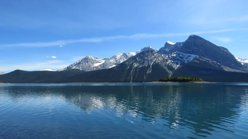
Park outlines use the Government of Alberta’s Parks and Protected Areas dataset, including the Spray Valley boundary identified as O.C. 389/2025. The government does not endorse this map; written legal descriptions take precedence over GIS linework. The north-up map uses a local equirectangular display at 50.8°N; its scale is approximate. The featured photograph is Upper Kananaskis Lake by Akiroq, June 2016, CC0; cropped, resized and converted to WebP. It shows historical scenery, not current lake conditions.
- Alberta Parks: Kananaskis Country information
- Alberta Parks: Peter Lougheed landscape
- Alberta Parks: Spray Valley landscape
- Alberta Parks: Bow Valley landscape
- Alberta Parks: Elbow-Sheep Wildland
- Alberta Parks: Bluerock Wildland
- Geological Survey of Canada: Geology, Kananaskis Lakes
- Geological Survey of Canada: Kananaskis west-half geology
- Alberta Parks: Kananaskis history
- Alberta: Kananaskis Conservation Pass
- Alberta Parks: Annual road closures
- Alberta: Kananaskis Public Land Use Zone