Denmark is a country where narrow stretches of water matter as much as the land between them. Jutland connects it to continental Europe, while islands, straits and fixed links organize travel and settlement farther east. Understanding that compact European landscape also requires separating Denmark itself from the much wider Kingdom that includes Greenland and the Faroe Islands.
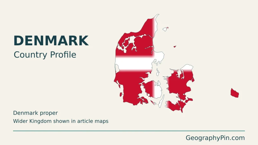
Denmark is a Northern European country with Copenhagen as its capital. Denmark proper comprises the Danish part of Jutland and its islands, including Zealand, Funen and Bornholm. Its low, glacially shaped landscapes lie between the North Sea and Baltic approaches. Greenland and the Faroe Islands are self-governing parts of the wider Kingdom, not included in the Denmark-only statistics below.
How to use this article: Compare Jutland and the islands, understand Denmark versus the Kingdom, or see how water and transport shape the cities.
1. Locate Denmark and read its map
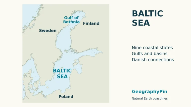
Denmark proper lies south of Norway and southwest of Sweden. The Danish part of Jutland has a land border with Germany; the North Sea lies to its west. The Skagerrak and Kattegat separate northern Jutland from Norway and Sweden, while the Danish straits connect the Baltic Sea with the waters farther west.
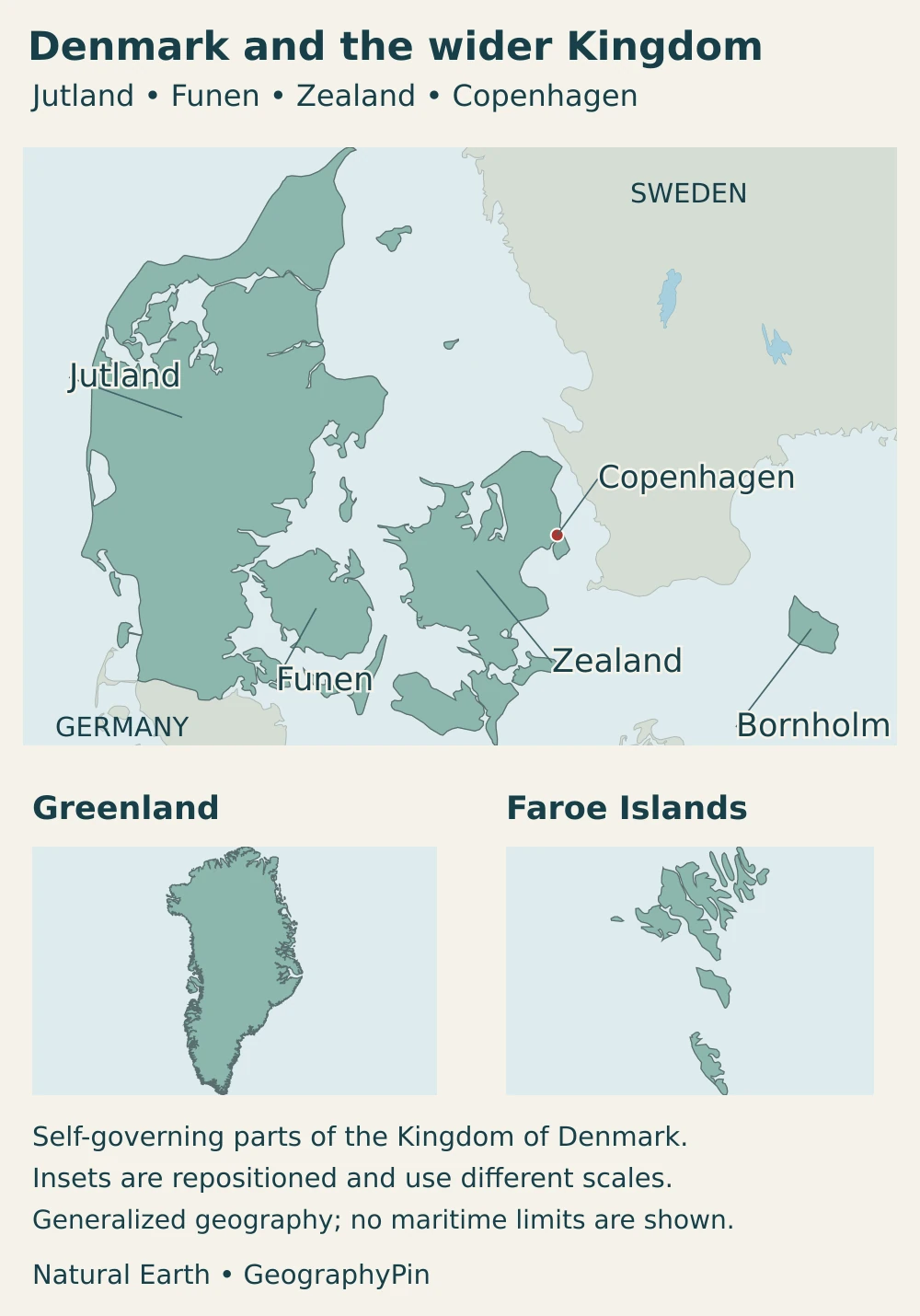
Copenhagen is on the eastern side of Zealand and extends onto Amager, facing Sweden across the Øresund. Funen lies between Zealand and Jutland. Bornholm is farther east in the Baltic, geographically separated from the main island group. A country map that crops out Bornholm misses an important part of Denmark proper.
Denmark belongs to both Scandinavia and the broader Nordic region, but it is not on the Scandinavian Peninsula in the same way as Norway and Sweden. The distinction is explained in Scandinavia versus the Nordic countries. Neither term has the same membership or meaning as the European Union.
2. Country facts with dates and scope
| Item | Figure or description |
|---|---|
| Capital | Copenhagen |
| Population | 6,044,001 on October 1, 2026; Statistics Denmark’s registered-resident series |
| Area | About 16,586 square miles (42,957 km²), Statistics Denmark’s January 1, 2026 cadastral-area measure |
| Statistical coverage | Denmark proper, excluding Greenland and the Faroe Islands |
| Language | Danish is the principal language of Denmark; Greenland and the Faroe Islands have separate language arrangements |
| Currency | Danish krone (DKK), not the euro |
| Government | Constitutional monarchy with parliamentary government |
| Regional structure | Five existing regions during the 2026 transition; four from January 1, 2027, following the eastern-region merger |
The population figure is based on officially registered addresses, not citizenship alone. It is not a combined total for the entire Realm. The October figure was released on November 10, 2026; figures for a later reference date should not be inferred from it.
The area figure also has a specific definition. Statistics Denmark calculates this series from registered cadastral areas, with many lakes excluded. It is therefore not a simple measurement of all land plus all inland water, and it is not the Kingdom’s area with Greenland added. Other official geographic totals can differ because they use different boundaries, water coverage or mapping methods.
3. Jutland, the islands and the wider Kingdom
A low landscape with meaningful contrasts
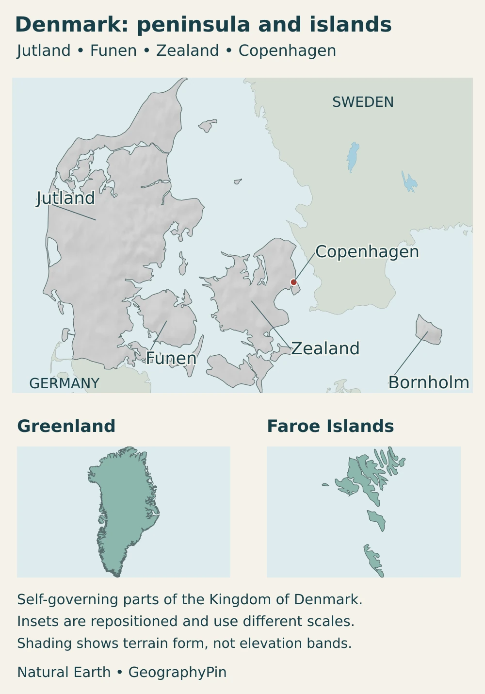
Denmark’s generally modest elevations do not mean its terrain is uniform. Repeated glaciations left deposits and landforms across much of the country. Eastern areas commonly have clay-rich glacial deposits and rolling terrain; western Jutland includes sandy meltwater plains and remnants of older glacial landscapes. Those differences affect drainage, soils and the appearance of the countryside.
| Area | Landscape | Geographic significance |
|---|---|---|
| Western Jutland | Sandy plains, older glacial uplands and exposed coastal stretches | North Sea exposure and mobile coastal sediments contrast with more sheltered eastern settings |
| Eastern Jutland | Rolling glacial terrain, valleys and indented shores | Coastal cities and inland routes connect agricultural districts with ports |
| Funen and Zealand | Low to rolling island landscapes separated by straits | Fixed links connect settlements without removing the islands’ geographic separation |
| Bornholm | Contrasting rock types, including exposed crystalline bedrock | A distinctive Baltic island, not a continuation of Zealand’s immediate surroundings |
| Southwestern Wadden Sea coast | Tidal flats, channels, salt marshes and barrier-island settings | A changing boundary between land and sea, extending beyond Denmark into Germany and the Netherlands |
These are broad landscape comparisons, not administrative regions. Bornholm is particularly useful as a counterexample to the idea that all Danish surfaces are alike: older rocks are exposed there, whereas much of the rest of Denmark is mantled by younger sediments. Locally steep coastal slopes can also occur in a country often described as flat.
Denmark proper is not the whole Kingdom
The Kingdom includes Denmark, Greenland and the Faroe Islands. Greenland and the Faroes have their own elected institutions and extensive self-government; they are not ordinary Danish regions equivalent to Jutland or Zealand. Greenland’s Arctic geography and the Faroes’ North Atlantic island setting cannot be described by Denmark proper’s climate or terrain.
Greenland’s self-government framework recognizes the Greenlandic people’s right to self-determination and provides for responsibility to be transferred in specified fields. The Faroese home-rule and takeover arrangements likewise provide extensive autonomous powers. Those distinct arrangements matter more than treating all three parts as an undifferentiated area on a map.
Separate-scale map insets help locate the parts of the Realm, but their apparent size and spacing are not a true area or distance comparison. A small Greenland inset does not mean Greenland is similar in size to Zealand.
4. Climate, rivers and coastal environments
Between Atlantic air and the European continent
Denmark proper has a temperate coastal climate. Westerly winds commonly bring ocean air and changing weather systems, moderating winter cold and summer heat. Air arriving from the continent can produce colder winter conditions or hotter summer weather. The surrounding seas influence the climate, but they do not prevent frost, snow, heat or strong storms.
Wind direction, season and exposure matter more than a single national average suggests. An open North Sea shore is not the same setting as a sheltered inlet or an inland town. Long summer days and short winter days also shape the seasonal experience, without making Denmark proper an Arctic landscape.
Short drainage routes and dynamic shores
The Gudenå is a useful river example: it rises near Tørring in Jutland and drains toward Randers Fjord. At approximately 99 miles (160 km), it connects inland landscapes with a coastal receiving water rather than forming a continent-scale river system. Rivers, lakes and wetlands are important even where their catchments are small compared with those of larger European countries.
Along the southwestern coast, the Wadden Sea’s tidal flats and channels shift with the movement of water and sediment. This coastal ecosystem crosses national borders. Its Danish section belongs to a much larger landscape shared with Germany and the Netherlands, so the World Heritage property should not be confused with Denmark’s entire coast.
Coastal flooding and erosion are different processes: high water can inundate low ground, while waves and currents can remove shoreline material. Dikes, dunes and coastal management influence local exposure. A low national elevation does not imply that every town faces the same hazard, and a general map cannot replace a local flood assessment.
5. People, cities and languages
Cities linked across water
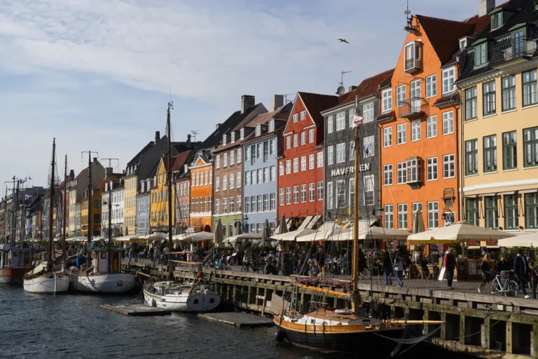
Copenhagen is the capital and the center of Denmark’s largest continuous urban area. Statistics Denmark counted 1,408,575 residents in the capital urban area on January 1, 2026. That figure describes a continuous built-up area, not Copenhagen municipality or the administrative Capital Region. The 2026 release used previously available urban boundaries rather than a new delineation of every built-up area.
Other major urban centers occupy different parts of the country: Aarhus is on eastern Jutland, Odense is on Funen, and Aalborg is in northern Jutland by the Limfjord. Their settings help explain why a Denmark overview needs more than a Copenhagen inset. Cities, smaller towns and rural districts are connected by road, rail, ports and ferries, with water crossings acting as important links in the network.
The Great Belt fixed link connects Funen and Zealand. The Øresund fixed link connects the Copenhagen side with southern Sweden using a tunnel, an artificial island and a bridge carrying road and rail. It is not simply a road bridge from central Copenhagen. These links support movement across straits while the underlying island geography remains.
Languages follow distinct communities and institutions
Danish is the principal language in Denmark proper. Across the wider Realm, Greenlandic has official status in Greenland, while Faroese is recognized as the principal language in the Faroe Islands and Danish can also be used in official matters there. These are not merely local names for Danish: the self-governing parts have their own linguistic and institutional settings.
6. Government and economy in their geographic setting
Denmark has a constitutional monarchy and parliamentary government, with the Folketing as its national parliament. Denmark proper’s regional administration is undergoing a dated transition: the Capital Region and Region Zealand continue their responsibilities during 2026, while the new eastern council prepares for the merged Region Eastern Denmark from January 1, 2027. This changes the number of regions from five to four, not the physical boundaries of Zealand or the status of Greenland and the Faroes.
The landscape makes agriculture highly visible. Statistics Denmark classified 57.7% of the country’s area as agricultural land cover in 2024. That is a measure of the surface, not agriculture’s share of employment or economic output. Ports and shipping connect the country with international trade, while urban activities and industries extend well beyond the farms visible from a road or train.
Wind power is another geographic connection. Exposure to wind on land and at sea supports generation, while cross-border electricity connections help balance the wider power system. Energinet’s 2025 report identifies wind as Denmark’s leading electricity-generation source. Electricity generation is only one part of energy use: transport fuels, heating and industrial energy should not be assumed to have the same renewable share.
Denmark is an EU member but retains the Danish krone. Greenland and the Faroe Islands are outside the EU, despite being parts of the Kingdom. EU participation, the Realm’s constitutional structure and Nordic identity therefore describe different relationships. For the narrower question of its economic model, see whether Denmark is socialist.
Frequently Asked Questions
Do Denmark’s population and area figures include Greenland and the Faroe Islands?
Not the Statistics Denmark figures used here. They describe Denmark proper. Greenland and the Faroes are self-governing parts of the wider Kingdom with separate statistical coverage. Always check the geographic definition before combining or comparing totals.
Is Denmark a peninsula or an island country?
Both settings are important. Denmark includes the Danish part of the Jutland Peninsula and numerous islands. Zealand and Funen are central to its settlement and transport network, while Bornholm lies farther east in the Baltic. Fixed links connect some islands without turning them into a peninsula.
What Did We Learn Today?
Denmark’s geography combines Jutland, low and rolling islands, and straits that shape transport and settlement. Glacial history helps explain the contrast between sandy western landscapes and many eastern areas, while tides and coastal processes continue to reshape its shores. Copenhagen’s urban area is not its municipality, and Denmark proper’s statistics do not include Greenland or the Faroe Islands. Keeping those definitions clear makes both the maps and the country facts more useful.
Sources & Data Notes
- Statistics Denmark, population figures: October 1, 2026 registered population; released November 10.
- Statistics Denmark, land use accounts: 2026 area and 2024 agricultural land-cover share; different reference dates.
- Statistics Denmark, land-account definitions: Cadastral-area coverage, excluded lakes and exclusion of Greenland and the Faroes.
- Statistics Denmark, urban areas 2026: Corrected May 21 release; January 1 population using previously available urban boundaries.
- Danish Prime Minister’s Office, the Realm: Self-government and different EU relationships.
- Danish Prime Minister’s Office, Greenland: Self-government, institutions, self-determination and language status.
- Danish Prime Minister’s Office, Faroe Islands: Home-rule and takeover arrangements; language context.
- Danish Regions, regional transition: 2026 transition and four-region structure from January 1, 2027.
- European Union, Denmark country overview: Capital, parliamentary monarchy, currency and EU membership; national statistics above use DST instead.
- GEUS, Danish geological setting: Glacial deposits and Bornholm bedrock; stable physical geography.
- Luetzenburg and colleagues, national landslide inventory: Peer-reviewed regional surface-geology and slope context, not a current local hazard forecast.
- Danish Meteorological Institute, climate report: General climate explanation in the English summary; not a current weather forecast.
- Randers Municipality, Gudenå: River source, approximate length and outlet.
- UNESCO, Wadden Sea: Transboundary tidal habitats and geographic scope.
- Danish Environmental Protection Agency, storm surges: Coastal lowland exposure and protective measures.
- Sund & Bælt, Øresund fixed link: Route and combined road, railway, bridge and tunnel structure.
- Sund & Bælt, Great Belt fixed link: Established connection between Funen and Zealand.
- Energinet, Electricity Market Report 2025: Generation sources and interconnectors, distinguished from total energy use.
- Danish Shipping, industry evidence: Industry-association primary evidence for maritime activity; no fleet ranking reproduced.
- Danish transition legislation: Sections 2 and 4 distinguish the 2026 transition from the January 2027 regional merger.
- Danish Language Council, language status: Danish usage and legal context; no general constitutional official-language clause asserted.
Map sources and scope: Original GeographyPin maps use public-domain Natural Earth country, lake and populated-place geometry, with its georeferenced shaded-relief raster. The main panel shows Denmark proper, including Bornholm. Greenland and the Faroe Islands are separately labeled self-governing parts of the wider Kingdom, not ordinary Danish regions.
Each panel uses a locally centered Lambert azimuthal equal-area projection, but the inset panels are repositioned and independently scaled: apparent areas and distances cannot be compared between them. Coastlines and small islands are generalized, not a complete inventory of every offshore feature. No maritime boundaries, current glacier limits or detailed treaty demarcations are shown. Denmark’s subtle relief is not rescaled into exaggerated mountain belts; the island insets show outlines only. The mapped outlines are not the cadastral measurement used for the statistical area above.
The cover shows Denmark proper only, using the public-domain Danish flag vector by Madden and other contributors. Flag proportions are preserved before decorative clipping. It does not apply Denmark’s flag to Greenland or the Faroe Islands. These illustrations are original GeographyPin compositions, not official government maps.