Summer winds can bring cooler water to parts of a tropical coast rather than simply warming the sea. In the Arabian Sea, that seasonal reversal links coastal upwelling, marine life and the wider geography of the Indian Ocean.
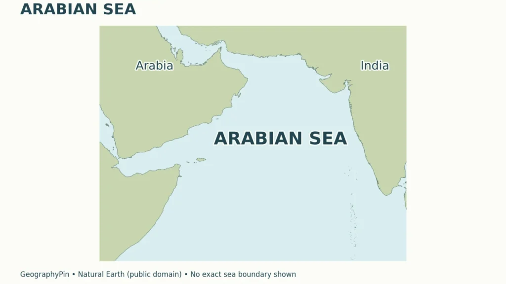
The Arabian Sea is the northwestern part of the Indian Ocean, between the Arabian Peninsula, India and the Horn of Africa. It connects with the Gulf of Oman and Gulf of Aden but is distinct from the Persian Gulf. Seasonal monsoon winds strongly influence its currents, coastal upwelling and marine productivity.
How to use this article: Identify the coastal countries, separate the neighboring gulfs, or follow the seasonal winds.
1. Where Is the Arabian Sea?
The Arabian Sea occupies the northwestern part of the Indian Ocean, between the Arabian Peninsula and India, with the Horn of Africa on its western side. Unlike an enclosed inland sea, it opens into the wider ocean to the south. Its coasts, island groups and neighboring gulfs give it a recognizable regional identity within that connected ocean.
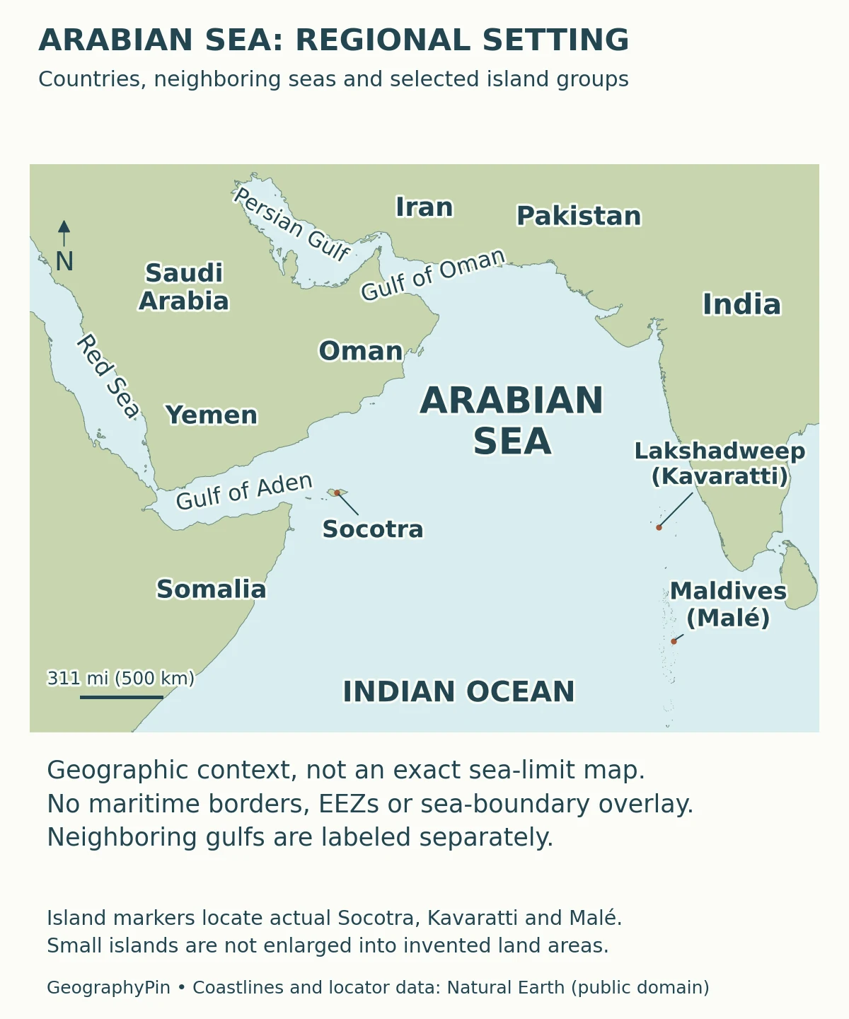
Which countries face the Arabian Sea?
Pakistan and India lie along the northern and eastern side; Oman and Yemen occupy the Arabian side; Somalia borders the western approach. These mainland relationships are useful starting points, but a list becomes misleading if it silently includes every country bordering an adjoining gulf.
| Country or island group | Relationship |
|---|---|
| Pakistan and India | Northern and eastern mainland coasts; India also includes Lakshadweep. |
| Oman and Yemen | Arabian Peninsula coasts; both also face separately named neighboring waters. |
| Somalia | Western mainland coast and the Horn of Africa setting. |
| Maldives | Island chain along the southeastern boundary area in the IHO’s 1953 convention. |
| Iran | Faces the Gulf of Oman and Persian Gulf; those are distinguished from the main Arabian Sea here. |
Socotra lies offshore from the Horn of Africa and belongs to Yemen. Lakshadweep is Indian territory, while the Maldives is a separate country. An island label is therefore not automatically another coastal country, and a nearby mainland label does not mean that all of its shore faces the same named sea.
2. The Neighboring Gulfs Are Not Interchangeable
Follow the connections rather than merging the names
The Gulf of Oman extends northwest from the Arabian Sea toward the Strait of Hormuz. Beyond that strait lies the Persian Gulf. The Gulf of Aden lies farther west, between Yemen and the Horn of Africa, and leads through Bab el-Mandeb to the Red Sea.
These names identify connected but distinct water bodies. The Arabian Sea is not another name for the Persian Gulf, and “Arabian Gulf,” a name used for the Persian Gulf in some regional contexts, should not be read as “Arabian Sea.” A route through connected waters may cross several named regions without ever leaving the ocean system.
Where does one named sea end?
The International Hydrographic Organization’s Limits of Oceans and Seas, third edition (1953), separates the Gulf of Oman from the Arabian Sea with a line between Ras al Hadd in Oman and Ras Jiyuni on Pakistan’s coast. Its southern Arabian Sea limit runs between the southern end of Addu Atoll in the Maldives and Ras Hafun in Somalia; the eastern limit follows the western side of the Laccadive Sea.
That is a historical geographic naming convention, not a coastline visible on the water or a modern territorial boundary. A scientific study may use a wider Arabian Sea region for its own analysis. Always check the source’s definition before comparing country lists or area figures.
3. Monsoon Winds Reverse With the Seasons
Southwesterly describes where the wind comes from
The Arabian Sea is strongly influenced by the Indian monsoon. In the northern summer, prevailing winds over much of the basin are southwesterly: they blow from the southwest toward the northeast. In northern winter, the prevailing pattern is northeasterly, blowing from the northeast toward the southwest.
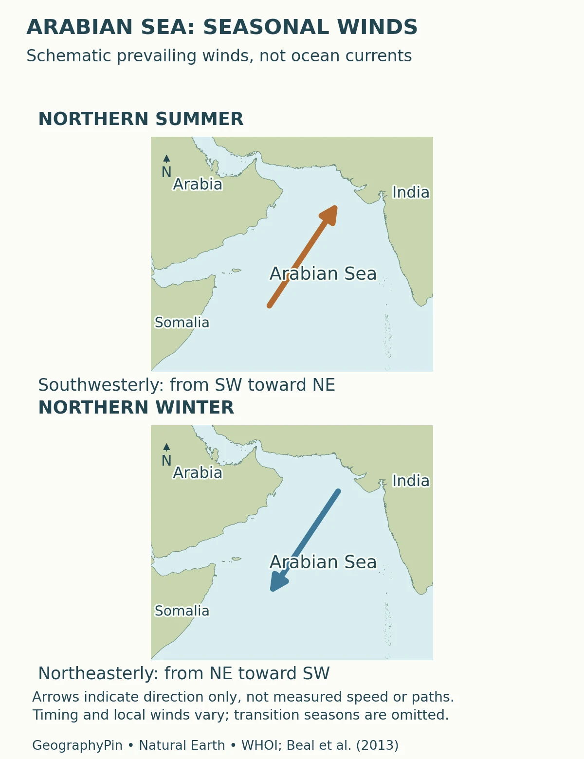
The names can seem backwards if you read an arrow as its destination. A southwest monsoon arrow should point generally northeast, because meteorological wind names describe the direction of origin. Reversing that convention reverses the physical meaning of the diagram.
A monsoon is a seasonal circulation pattern, not simply a synonym for a rainstorm. Rainfall, wind strength and the timing of the seasonal change vary across the region. The two panels show the broad contrast, not an assertion that the wind blows identically at every coast or changes direction on one fixed date.
Ocean currents respond to these winds, but water does not everywhere move in the same direction as the air above it. Earth’s rotation, the coastline, pressure differences and water-column structure affect the response. Our ocean-current explainer separates wind arrows from water movement.
4. Why Coastal Waters Can Cool in Summer
Water rises to replace water moved away from shore
During the southwest monsoon, wind-driven transport can move surface water away from parts of the western Arabian Sea coast, notably off Oman and Somalia. Water from below rises to replace it. This process, upwelling, helps explain why some coastal waters become cooler during the summer monsoon rather than simply warming with the season.
Upwelled water commonly carries nutrients into the sunlit upper ocean. Those nutrients support phytoplankton, the microscopic photosynthetic organisms at the base of marine food webs. This is a connection between physical circulation and biological productivity, not a guarantee of a particular fish catch.
The mechanism is spatially uneven. Research from the Arabian Sea distinguishes coastal upwelling from convergence, downwelling and mixing elsewhere in the basin. It would be wrong to color the entire sea as one continuous upwelling zone or infer that a cold patch marks the same process everywhere.
Winter can also deepen and cool the surface mixed layer, but through a different combination of northeast winds and surface cooling. Cooling can make surface water denser and promote mixing. Thus, two productive seasons do not require the same coastal upwelling mechanism to operate unchanged all year.
A 2024 study comparing the western coastal Arabian Sea with the Bay of Bengal also shows why surface temperature is not a universal measure of upwelling strength. Different temperature and salinity structures can produce different surface signatures. A satellite color pattern needs physical context, not just a label.
5. A Sea Connected to Major Shipping Passages
Two different passages lead toward two different gulfs
The sea’s transport importance becomes clearer when the connections are read in order. From the Persian Gulf, a sea passage runs through the Strait of Hormuz → Gulf of Oman → Arabian Sea. Toward the Red Sea, the corresponding sequence is Arabian Sea → Gulf of Aden → Bab el-Mandeb → Red Sea.
The International Energy Agency describes Hormuz as the narrow connection between the Persian Gulf and the Gulf of Oman–Arabian Sea system. The U.S. Energy Information Administration identifies Bab el-Mandeb as the chokepoint linking the Red Sea with the Gulf of Aden. They are separate passages serving different parts of the regional network.
This geography explains why the Arabian Sea matters to routes between western Asia, South Asia and the wider Indian Ocean. It does not mean every vessel follows one line across the basin, or that a broad map can represent current traffic restrictions and navigational conditions.
The distinction also helps locate cities. Muscat faces the Gulf of Oman, not the Persian Gulf. Describing its regional connection to the Arabian Sea is useful; replacing the name of its immediate coastal water with a different gulf is not.
6. How to Read Arabian Sea Maps and Measurements
Check the boundary, the variable and the time
Before using an Arabian Sea statistic, ask what area the source includes. A regional oceanographic study, a forecast zone and a historical sea-limit definition may have different edges. A quoted surface area is meaningful only with the boundary used to calculate it; a depth measurement describes the seabed, not the size of the sea.
Then check what the map actually shows. Coastlines locate land and water. A wind diagram describes airflow. A current chart describes water movement, while a sea-surface-temperature image measures a different variable again. One cannot substitute for another merely because all cover the same region.
Finally, distinguish a typical seasonal pattern from conditions on a particular day. INCOIS, India’s ocean-information agency, provides operational ocean forecasts because waves, swell, winds, tides and currents matter separately to coastal and offshore activities. A monsoon sketch is an explanation, not a forecast for sailing, swimming or a harbor approach.
For the larger setting, our world oceans map places the Arabian Sea within the Indian Ocean. Start at that scale, then move to the regional gulfs and coasts, and only then to local marine information. The changing scale is what turns a familiar sea name into an understandable geography.
What Did We Learn Today?
The Arabian Sea is an open part of the Indian Ocean with separately named neighboring gulfs. Country lists depend on whether those gulfs are included. Monsoon winds reverse seasonally, but wind arrows are not current arrows, and coastal upwelling is not a uniform process across the entire basin.
Sources & Data Notes
The map shows regional context without an exact sea-limit polygon. Where named limits are discussed, the convention is explicitly IHO 1953; other regional definitions are not silently combined with it. Wind arrows show schematic seasonal direction, not speeds, ocean-current paths or present conditions.
- IHO: Limits of Oceans and Seas, third edition (1953). Pages 20–21, Arabian Sea and neighboring waters. Historical geographic limits, not maritime jurisdictions.
- Honjo and Weller, WHOI (1997): Monsoon Winds and Carbon Cycles in the Arabian Sea. Research-based account of monsoon forcing, coastal upwelling and winter mixing.
- Abbott and Mahadevan (2024): coastal upwelling comparison. WHOI research summary; original study DOI 10.1029/2024JC022023.
- NOAA: What is upwelling?. Surface-water replacement, nutrient supply and the distinction from downwelling.
- National Weather Service: monsoon information. Seasonal circulation and wind reversal.
- International Energy Agency: Strait of Hormuz. Physical connection between the Persian Gulf and Gulf of Oman; no traffic-volume figures are reproduced here.
- U.S. Energy Information Administration: Bab el-Mandeb. Red Sea–Gulf of Aden connection; historical shipping statistics are not treated as current.
- INCOIS: ocean information and forecasting. Why operational sea-state information differs from a seasonal geographic explanation.
Map sources and method: Original GeographyPin cartography uses Natural Earth public-domain coastlines and reference locations. Country geometries are combined into land outlines without international or maritime boundary lines. Socotra uses its named island polygon; Kavaratti and Malé use actual populated-place locations, not invented island-group centers. Small islands are not enlarged into new land areas. The main map uses a latitude-adjusted geographic aspect with an approximate scale bar. The seasonal wind panels are schematic, informed by WHOI and Beal and colleagues (2013); they do not reproduce a measured wind or current field.