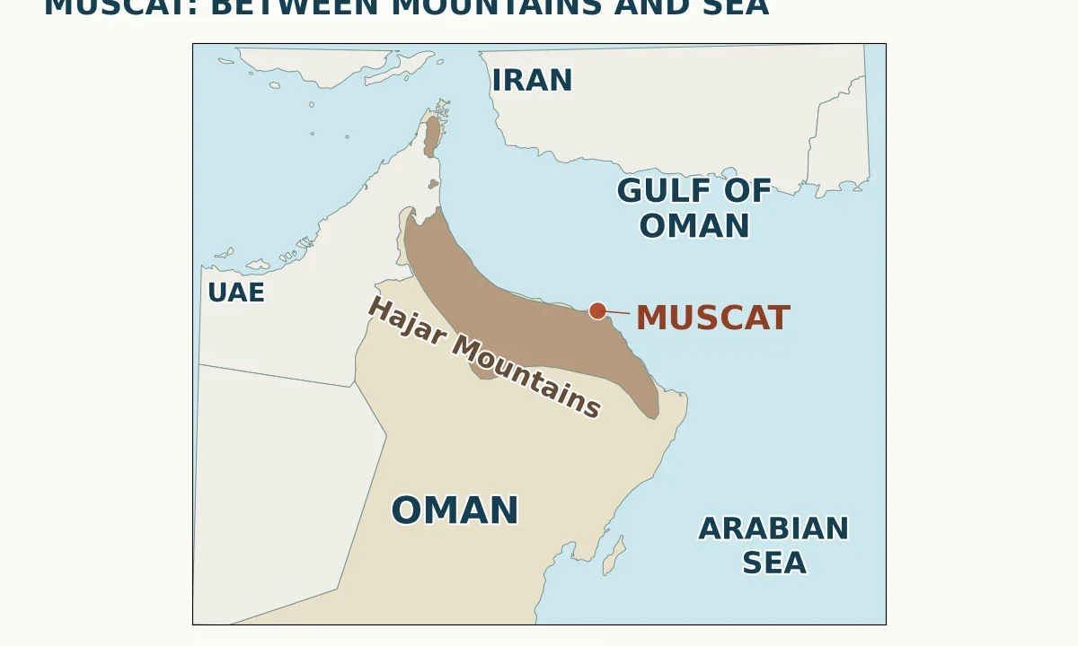
Muscat lies on the Gulf of Oman, with the Hajar Mountains forming its rugged backdrop. Oman’s capital occupies a coastal setting where rocky hills, bays and flatter land shape the urban area. Old Muscat and Muttrah are distinct historic centers within a much wider capital region; the Gulf of Oman connects southeastward with the Arabian Sea.
A map makes Muscat easier to understand than a list of landmarks. The city is not simply a dot beside a desert: its setting brings together a sea-facing coast, mountainous ground and several connected urban centers. Two distinctions matter immediately: the Gulf of Oman is not the Persian Gulf, and Old Muscat is not the whole modern capital.
Start with the names of the adjoining waters, compare the different meanings of Muscat, or use the map-reading notes to distinguish a locator from a street map.
1. Where is Muscat?
Muscat is the capital of Oman, on the northeastern side of the Arabian Peninsula. Its coastline faces the Gulf of Oman. Across that body of water lies Iran; following the water northwest leads toward the Strait of Hormuz, while the open connection to the southeast leads into the Arabian Sea.
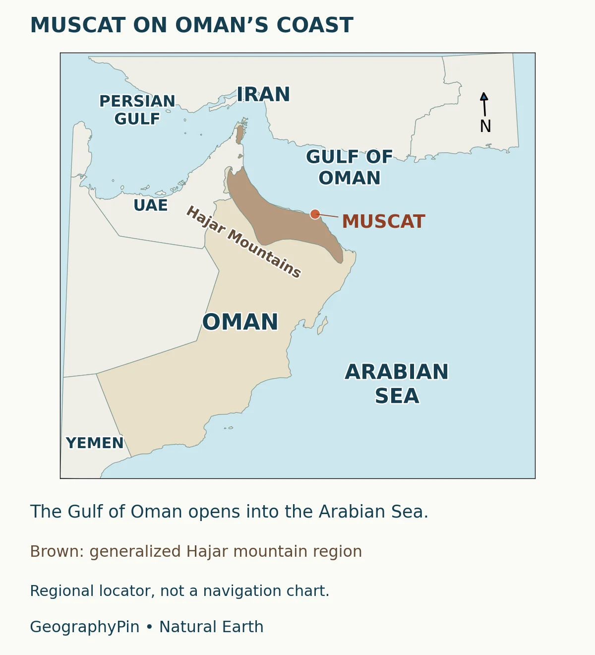
Muscat should also be distinguished from Musandam, Oman’s northern territory near the Strait of Hormuz. They belong to the same country but are not the same place. Muscat lies on the main Omani landmass, south of the strait. That distinction prevents a common mistake: transferring the location of Oman’s northern tip to the capital itself.
This is a coastal-city geography guide, not a complete country profile. For the opposite side of the gulf and the broader regional setting, see our geography of Iran.
2. Which sea is Muscat on?
Gulf of Oman, Sea of Oman and Arabian Sea
The most geographically specific answer is the Gulf of Oman. Omani government sources also use “Sea of Oman” for these waters. The Arabian Sea is the larger adjoining body of water to the southeast, not a replacement name for every part of Muscat’s immediate shoreline.
The relationship is easiest to picture as connected waters rather than separate enclosed basins: Persian Gulf, Strait of Hormuz, Gulf of Oman, then Arabian Sea. The strait links the first two gulfs. Muscat is on the Gulf of Oman side of this sequence, outside the Persian Gulf.
A broad description of Muscat as an Arabian Sea coastal city can therefore communicate the general ocean setting while losing useful local precision. For locating the city, labeling a map or answering which water borders it, use Gulf of Oman. The regional locator shows that connection without drawing a political boundary across the water.
3. Which mountains form Muscat’s backdrop?
The mountain backdrop belongs to the Hajar Mountains system. The range is a major physical feature of northern Oman. It should not be confused with the Dhofar mountains in the country’s far south or with the sand deserts of the interior.
At regional scale, the mountains curve through northeastern Oman roughly in sympathy with the coastline. NASA’s overview of northern Oman distinguishes these rugged heights from the low-lying coast where Muscat sits. That does not mean every neighborhood has the same elevation, nor that the low hills behind a waterfront are the range’s highest summits.
Names such as Western Hajar and Eastern Hajar describe subdivisions of a much larger mountain system. For a city overview, “Hajar Mountains” avoids assigning every hill around Muscat to one subdivision. The important relationship is clear without that extra claim: mountains and coastal lowlands meet within the setting of the capital.
Likewise, the brown shape on the regional map is a regional mountain label made visible. It is not a contour map, a slope measurement or the edge of an unbroken rock wall. Studying elevation in detail requires a terrain dataset at a finer scale. Our physical geography explainer introduces the wider study of landforms and natural processes.
4. Old Muscat, Muttrah and the wider capital
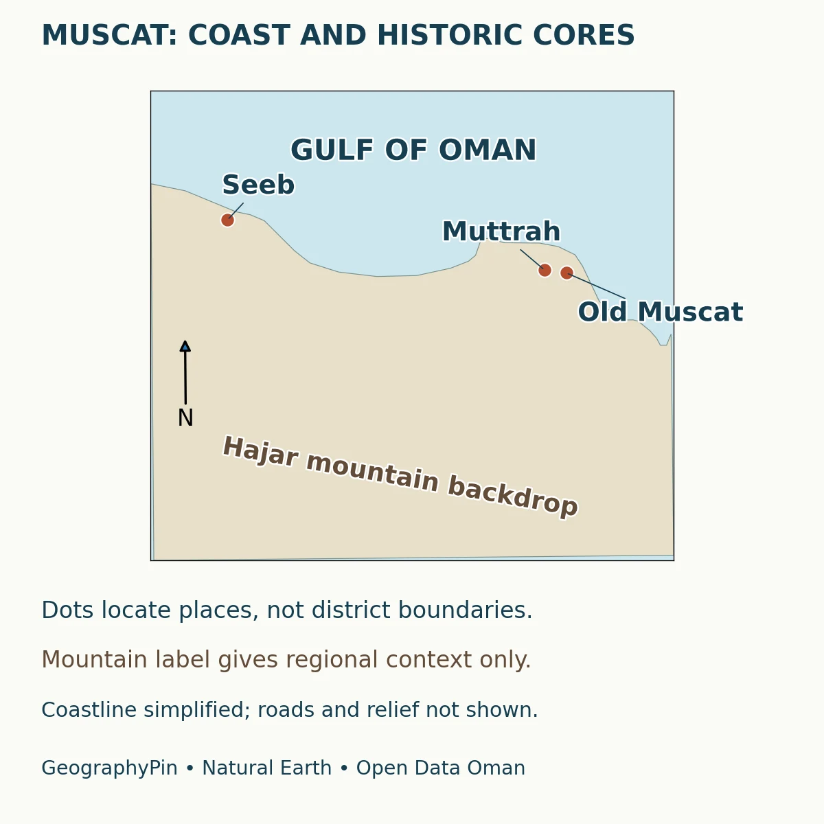
Old Muscat is the historic core associated with the palace and nearby forts, not a synonym for every neighborhood in the modern city. The National Museum identifies its location opposite Al Alam Palace in the Wilayat of Muscat. That provides a practical landmark for recognizing this particular part of the capital.
Muttrah, also written Matrah or Mutrah in English sources, is a separate historic center to the northwest. Its waterfront, harbor and market give it a maritime and commercial identity. Treating Old Muscat and Muttrah as interchangeable place names obscures the short but real geographic separation between them.
Three scales hidden in one place name
“Muscat” can refer to the historic core, the broader urban capital or the administrative governorate. A wilayat is an administrative subdivision, not simply another word for a neighborhood. Muscat Governorate includes six wilayats, among them Muscat and Muttrah as distinct units.
The wider capital extends well beyond these historic centers. Seeb lies farther west along the coast, while other urban areas occupy coastal land and inland settings. Consequently, a population or area labeled “Muscat” is not useful until its boundary and reference date are stated. A governorate total should not be presented as the population of Old Muscat.
5. How terrain shapes the city
Muscat illustrates how settlement responds to the space available between coast and mountains. Flatter ground offers different opportunities from steep slopes. Bays and intervening hills create distinct settings rather than one uniform waterfront. Roads connect these places, but a straight line between two map points does not represent the road journey.
A 2017 study by Sultan Qaboos University researchers described the city’s growth from separate settlements across a narrow coastal alluvial plain. Its analysis found increasing residential, commercial and industrial land use, including development in formerly vacant and agricultural areas. This is evidence about an urban-development process, not a current measurement of the city’s boundary.
The useful lesson is not that mountains make growth impossible. Instead, terrain helps explain why development connects and fills suitable spaces unevenly. The sea limits expansion in one direction; mountainous ground changes the conditions in another. Infrastructure, planning and land-use decisions also matter, so physical geography alone cannot explain every neighborhood.
When reading a city map, distinguish three things: the actual coast, the surrounding landforms and the human-built network. Our locator includes the first and a generalized indication of the second. It deliberately leaves out roads rather than implying that an invented connecting line is a real route.
6. Key facts and map-reading notes
| Question | Answer |
|---|---|
| Country | Oman |
| Immediate coastal water | Gulf of Oman, also called Sea of Oman |
| Mountain setting | Hajar Mountains system |
| Historic centers shown | Old Muscat and Muttrah |
| Wider western reference point | Seeb |
| Administrative caution | Old Muscat, the urban capital and Muscat Governorate are not interchangeable statistical areas. |
What the maps can and cannot tell you
The regional map answers where Muscat sits in relation to Oman and adjoining waters. The closer map answers how the selected places relate to one another. Both use generalized coastlines; neither resolves individual harbor walls, walking paths or buildings.
Enlarge the images to inspect the labels, but do not mistake a larger display for more detailed underlying data. The city dots are reference locations rather than surveyed centers of whole districts. Mountain shading on the regional map communicates a broad landform region, not a precise boundary between flat and steep ground.
What Did We Learn Today?
Muscat’s geography becomes clearer when the sea, mountains and urban scales are kept separate. The Gulf of Oman locates its immediate coast, the Hajar Mountains explain its rugged setting, and Old Muscat, Muttrah and Seeb help orient the wider capital. The same distinctions keep maps and statistics useful: a reference point is not a boundary, and a governorate is not just its historic city center.
Sources & Data Notes
The maps use Natural Earth’s generalized country and mountain-region geometry, projected in UTM zone 40N. Old Muscat and Muttrah use Al-Mirani Fort and Muttrah Fort as reference points; Seeb uses Natural Earth’s populated-place location. The regional map’s mountain shading is not measured relief; the city map uses only a contextual mountain label. No city population, metropolitan-area boundary or current travel time is inferred from these maps. The 2017 urban study is cited for its historical analysis, not as a current land-use survey.
- Oman Foreign Ministry: Oman by region, for Muscat’s coastal setting and administrative context.
- Muscat Municipal Council: wilayats of Muscat, for the separate places and coastal setting.
- NASA Earth Observatory: Northern Oman, for the regional relationship between mountains and coast.
- National Museum of Oman: location information, for the Old Muscat landmark setting.
- Al-Awadhi, Ramadan and Charabi (2017): Urban development and landuse change patterns in Muscat city, Oman, university research record and abstract.
- Natural Earth: country boundaries and geographic regions, public-domain basemap data; Open Data Oman: Coordinates of Omani Forts, for the two historic-center reference locations, reused and reprojected under CC BY 4.0.