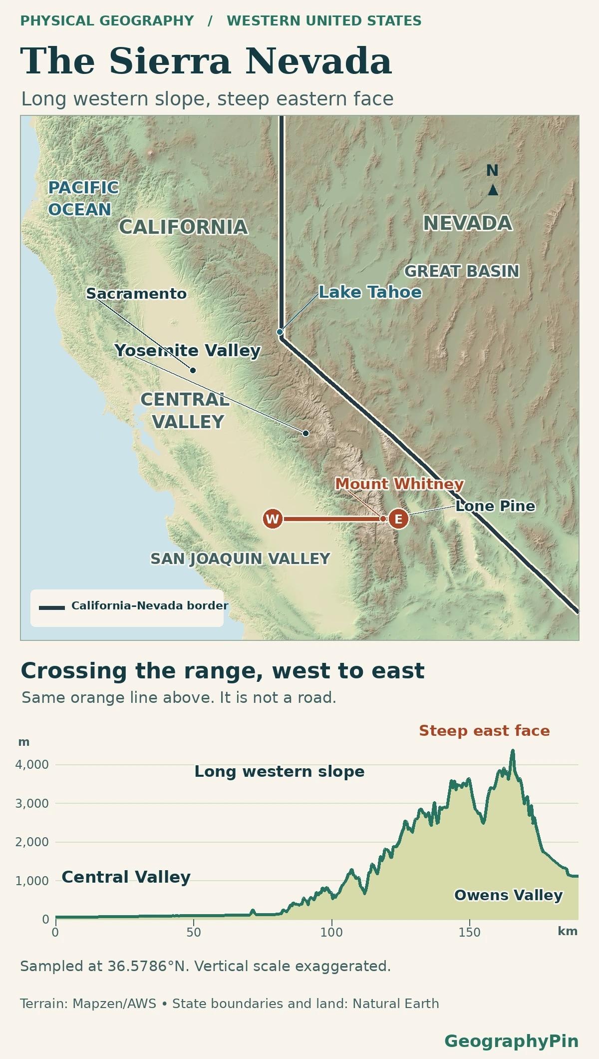
From California’s Central Valley the Sierra Nevada rises through foothills, but from Owens Valley the same range looks like a steep wall. A map across both sides shows why those views look so different.
The Sierra Nevada runs along eastern California and reaches into western Nevada. Its western flank rises from the Central Valley through a belt of foothills, while the eastern escarpment drops more sharply toward basins such as Owens Valley. Mount Whitney stands on the southern crest, not on the valley floor.
How to use this article: Start with the west-to-east terrain profile, check where the western foothills give way to the valley or see why the east face is steep.
Where the Sierra Nevada runs
Find California’s long Central Valley, then look east. The Sierra Nevada is the mountain belt between that valley and the Basin and Range country. The 2026 California Geological Survey and U.S. Geological Survey atlas places most of the range in California and a small part in western Nevada. The state line is not its eastern edge.
Read the two sides of the crest on one profile
A west-to-east cross-section through the southern Sierra shows why the slopes look different. From the Central Valley the land rises through foothills and higher mountain country; after the crest it drops much more abruptly toward Owens Valley. The profile samples one crossing. It does not measure the height of every peak or show a route to the summit.
The Central Valley side: a long climb through foothills
On the west side, the transition from valley floor to mountains spans a broad belt of foothills. That gentle rise is a comparison at the scale of the whole flank, not a claim that the west side has no cliffs. At Yosemite, for example, rivers and glaciers cut deeply into the western side and left steep valley walls, as the National Park Service’s Geodiversity Atlas explains.
Why the foothills look different on a groundwater map
A relief map fades from mountains to plain. A USGS groundwater study of the northern foothills instead used the eastward extent of the Central Valley’s young sediments as the lower edge of its study area. That gives researchers a repeatable line for a particular question. It is not a rule for drawing the whole western flank farther south.
The eastern escarpment: a short drop toward Owens Valley
Why the eastern face is steeper
The National Park Service describes the Sierra Nevada as an uplifted block of crust tilted toward the west. The high side is near the eastern crest. The USGS synthesis of Owens Valley and nearby basins also documents faulting and crustal stretching along the eastern margin. The combination helps explain the contrast: the land rises over a longer distance from the west and drops more abruptly toward faults and lower basins on the east. Rivers and glaciers then cut valleys into the slopes.
A 2026 USGS study of Nevada-area streams uses this tilted-block description for the Sierra Nevada ecoregion. The geomorphic explanation does not fix a single date when today’s entire range rose; the timing and history of uplift are still debated in USGS research on the central Sierra.
Mount Whitney and Lone Pine are on different terrain
Mount Whitney rises on the southern Sierra crest to about 14,500 feet (4,420 meters). The National Park Service’s Whitney guide identifies the summit of the highest mountain in the contiguous United States. Lone Pine lies east of the mountain, on the Owens Valley side of the range. Near it, the USGS Lone Pine quadrangle distinguishes the Sierra face, the rounded Alabama Hills, the basin and the Inyo Mountains farther east.
That sequence is a useful check when looking at a photo or a map. The rounded foreground hills can be part of the Eastern Sierra region people visit without being the high crest you see behind them. Likewise, the highest point along one grid-sampled terrain slice is not automatically the surveyed summit.
Which boundary does a Sierra Nevada map show?
The mountains, the rocks beneath them and the area a public agency manages are not identical. The 2026 California Geological Survey–USGS map groups rocks by age and type and includes adjoining areas for context. A physiographic map groups the land by its shape and related landforms. Both can be useful without putting every edge in the same place.
Lone Pine is a good example. On a terrain map it is at the base of the east side, in Owens Valley rather than on the mountain crest. The Sierra Nevada Conservancy’s service area explicitly includes Owens Valley, so the town sits inside that broader administrative region. Before using an outline, identify what the line is meant to enclose.
Frequently Asked Questions
Why do sources give different elevations for Mount Whitney?
The NPS Whitney visitor page reports 14,505 feet (4,421 meters), while a park fact sheet lists 14,494 feet (4,418 meters) and flags uncertainty. Rather than treating those pages as identical measurements, the map description rounds the height. The USGS also notes that a value interpolated from a terrain grid can miss a peak.
Is Lake Tahoe on the Sierra Nevada crest?
No. The USGS map of the Lake Tahoe Basin places the basin between Sierra Nevada peaks on the west and the Carson Range on the east. The California–Nevada boundary crosses the lake, not along either crest.
Is Whitney Portal the same place as Mount Whitney?
No. The National Park Service maps Whitney Portal as a trailhead on the east-side approach from Lone Pine. The summit is a separate point on the crest. A map with just the mountain name should not be used to locate the trailhead.
What Did We Learn Today?
The Sierra Nevada rises gradually at regional scale from the Central Valley and drops more sharply on its eastern side. Near Mount Whitney, the crest, Alabama Hills and Owens Valley are distinct parts of that terrain. Read the range’s edge according to the map’s purpose, especially when a management area includes land outside the mountains.
Sources & Data Notes
The National Park Service, the U.S. Geological Survey, the California Geological Survey and the Sierra Nevada Conservancy provide the slope, geological and administrative distinctions. Mount Whitney’s height is rounded because official pages give different figures; the terrain profile samples one crossing, not the whole range.
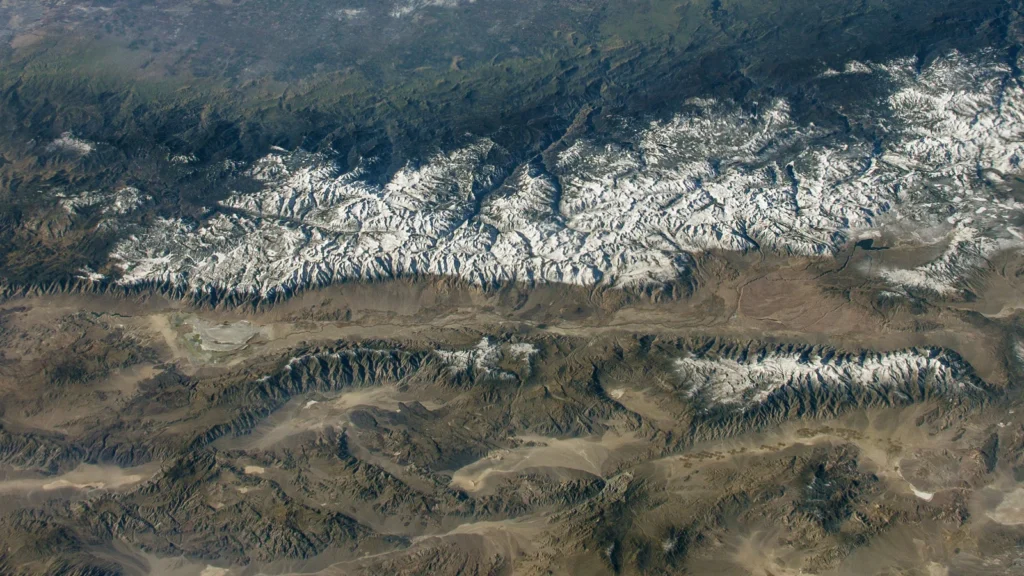
Photo: Sierra Nevada astronaut photograph ISS050-E-17326, December 19, 2016. Image courtesy of the Earth Science and Remote Sensing Unit, NASA Johnson Space Center (cropped). Map data: Natural Earth, Mapzen Terrain Tiles.