India stretches from high mountain landscapes to broad river plains and a peninsula projecting into the Indian Ocean. Its size alone does not explain its geography: mountain barriers, seasonal winds and different river basins create contrasts over surprisingly short distances. A useful country profile connects those landscapes with settlement while keeping national statistics, administrative boundaries and disputed territorial claims distinct.
India is a South Asian country with New Delhi as its capital. Its major landscapes include the Himalayas, the northern river plains, the peninsular plateau, desert areas, coastal plains and offshore islands. The Deccan and Western Ghats help explain southern terrain, while monsoon exposure produces major differences in rainfall between regions.
How to use this article: Compare the main landscapes, understand different rainfall seasons, or distinguish New Delhi from the wider Delhi region.
1. Locate India and read its map
India occupies a large part of South Asia. The Arabian Sea is to the west of its peninsula and the Bay of Bengal to the east, with the wider Indian Ocean to the south. Sri Lanka lies across the water from the southeastern peninsula, while the Maldives lie farther southwest.
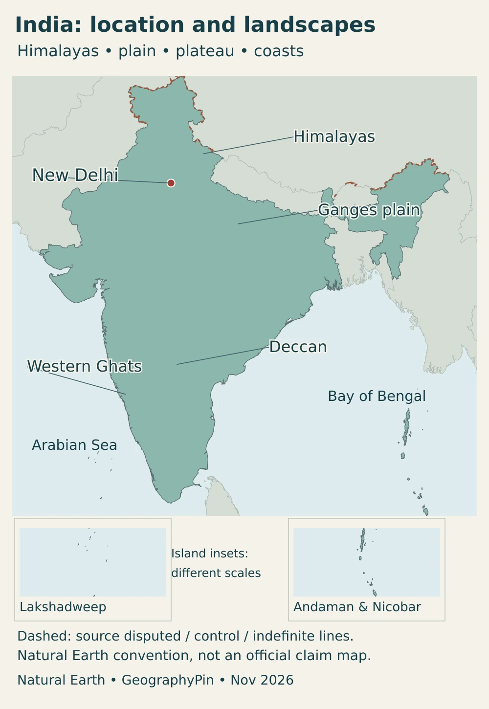
The mainland’s northern and northeastern geography includes mountain frontiers and lowland connections with neighboring countries. Pakistan lies to the northwest, Nepal and Bhutan along the Himalayan margin, Bangladesh to the east of the main peninsula and Myanmar farther east. India and China have disputed boundary sectors. A generalized country outline cannot resolve the difference between a territorial claim and present administration.
Lakshadweep lies off the southwestern coast in the Arabian Sea. The Andaman and Nicobar Islands form a separate, elongated island group far to the southeast in the Bay of Bengal and Andaman Sea region.
For the separate continental-location question, see whether India is in Asia. Our South Asia countries map provides the broader regional context; this profile focuses on India’s internal landscapes and connections.
2. Country facts with dates and scope
| Item | Fact |
|---|---|
| Capital | New Delhi, within the wider National Capital Territory of Delhi |
| Population projection | 1,425,908,000 for March 1, 2026, from the Ministry of Health and Family Welfare’s 2020 projection report based on Census 2011; not a new census count |
| Reported surface area | About 1,269,219 square miles (3,287,263 km²), UNData’s 2023 figure; land and inland water under the reported territorial accounting, not necessarily the same extent as the map convention |
| Currency | Indian rupee (INR) |
| Administrative structure | 28 states and 8 union territories, checked in November 2026 |
| Union official-language use | Hindi in Devanagari; English also used for official purposes under legislation |
A census counts people against a reference date; a projection estimates subsequent population using assumptions. An estimate for 2026 must not be relabeled as a 2026 census result. Likewise, an officially reported national area and a map assembled using a different disputed-boundary convention may not cover identical territory.
The figures here retain their source definitions rather than being combined into a falsely precise population density. The number of people in a municipal area, an urban agglomeration, a union territory or a planning region also describes different geographies.
3. Himalayas, plains and the peninsular plateau
The northern plains are not the Deccan
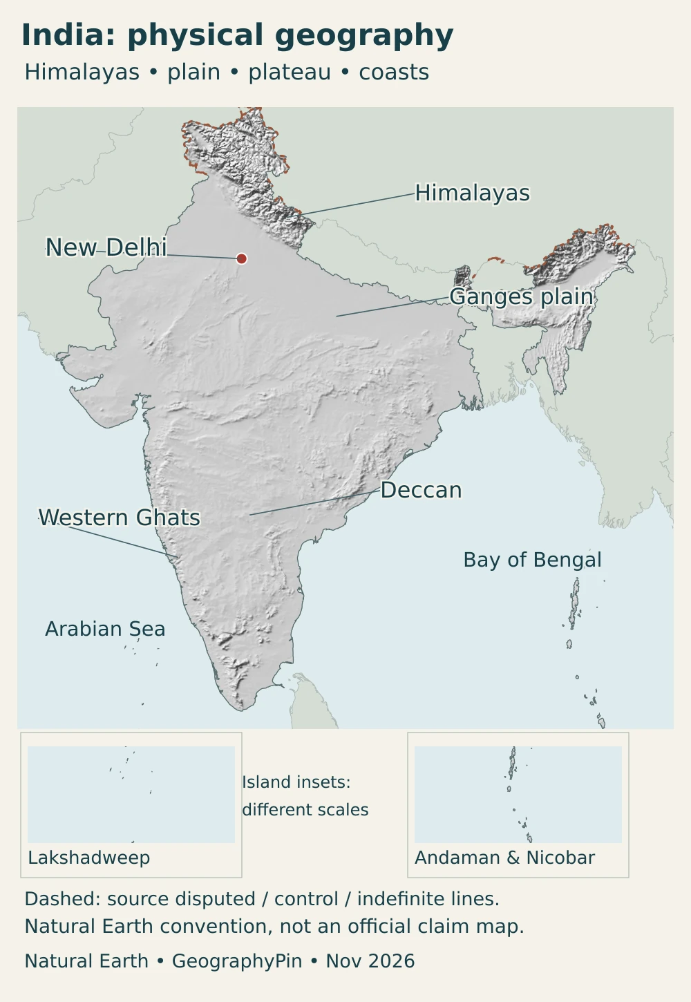
The Himalayas form a high, complex mountain system along the northern part of the subcontinent. South of them, extensive plains have developed from river-borne sediment. The peninsular interior is different again: older uplands and plateaus occupy much of the land farther south, with the Deccan forming a major part of that system.
| Setting | Landscape | Why it matters |
|---|---|---|
| Himalayan region | High ranges, steep valleys and large altitude differences | Topography influences routes, river headwaters and local climate |
| Northern river plains | Extensive alluvial lowlands associated with major river systems | Broad farming and settlement corridors coexist with shifting channels and flood exposure |
| Peninsular plateau and Deccan | Uplands, river valleys and varied ancient rocks, including areas of basalt | Drainage divides and plateau surfaces distinguish this interior from the northern plains |
| Western Ghats and coastal plains | Mountain barrier near the west coast, with lower coastal terrain | Windward slopes and inland rain shadows create sharp moisture contrasts |
| Northwestern arid landscapes | Desert and semi-arid terrain, not a uniformly sandy surface | Limited and variable rainfall makes water availability especially important |
| Offshore islands | Separated island groups in the Arabian Sea and eastern Indian Ocean region | Distance and sea connections distinguish them from mainland coastal districts |
The Western Ghats run broadly parallel to the western coast. They are not part of the Himalayas, and the Deccan does not mean every piece of land south of the Ganges. Plateau interiors, mountain margins and coastal plains are related but distinct settings. The Ghats’ position near the coast is particularly important because it places high ground in the path of moisture-bearing winds.
Region names describe broad patterns rather than uniform surfaces. A plateau contains valleys and hills; a plain can contain terraces and older river channels; a mountain region includes settled basins as well as peaks. The map labels are orientation aids, not surveyed boundaries enclosing places with identical landscapes.
4. Monsoons, rivers and environmental contrasts
One country, more than one rainy-season pattern
The southwest monsoon, conventionally discussed for June through September, is the principal rainy season across much of India. Moist air approaching from the Arabian Sea encounters the Western Ghats, where uplift favors rain on exposed slopes. Areas farther inland can lie in a rain shadow. This does not mean every western district is equally wet or the entire plateau is dry.
Southeastern India provides an important contrast. The India Meteorological Department identifies October through December as the northeast monsoon season, with particular importance for Tamil Nadu, Puducherry and nearby southeastern districts. Chennai’s seasonal rainfall pattern therefore cannot be inferred simply from the summer-rain calendar familiar in much of northern India.
Altitude adds another dimension: high Himalayan terrain is not climatically equivalent to a tropical coast. Seasonal totals also conceal differences between gentle rain, short intense downpours and long dry intervals. Monsoon climatology helps explain a landscape, but it is not a forecast for a particular journey or an assurance against flooding.
Following the basin rather than the nearest blue line
The Ganges, also called the Ganga, is central to the northern plains, while the Brahmaputra connects the eastern Himalayan region with Assam and Bangladesh. These are transboundary river systems: their water and sediment do not stop at national borders. Their combined downstream environment is different from the separate river basins of peninsular India.
The Godavari provides a useful southern example. Its basin extends from the western side of the peninsula across inland uplands toward the eastern coast. Tributaries collect water from different landscapes, and reservoirs, farms, settlements and freshwater habitats are linked along the system. It is not a tributary of the Ganges despite the traditional name “Ganga of the South.”
Rainfall is only one part of water availability. Storage, groundwater use, irrigation demand and the timing of flow influence how much water reaches different users. A floodplain can have a wet-season flood problem and a dry-season supply problem without either observation contradicting the other.
5. People, cities and languages
New Delhi, Delhi and the wider capital region
New Delhi is India’s capital, but the name should not be used interchangeably with every definition of Delhi. The capital’s central government district lies within the much larger National Capital Territory of Delhi. The New Delhi Municipal Council administers the central area containing major national institutions; the territory also contains other municipal jurisdictions.
The National Capital Region is a wider planning region that includes the NCT and districts in Haryana, Uttar Pradesh and Rajasthan. It is not simply another name for New Delhi or a boundary drawn around only continuous built-up land.
Urban comparisons require the same care elsewhere. A municipal corporation, a continuous built-up area and an urban agglomeration need not share one boundary. A number for the wider Delhi area should not be placed beside a municipal population for another city and treated as a like-for-like ranking.
Official language does not mean one national mother tongue
Hindi in the Devanagari script is the official language of the Union under the Constitution, while legislation also permits English for official purposes. That administrative arrangement does not mean that Hindi is everyone’s mother tongue or that it is constitutionally designated as a national language. India’s multilingual society is much broader than the language rules governing Union administration.
Physical regions and language regions are not interchangeable. The Deccan, for example, crosses several states and language communities. Neither a single color on a relief map nor a broad label such as “northern plains” describes everyone’s identity, history or language.
Settlement connects several kinds of landscape: river corridors, plateau cities, ports and mountain valleys. India is not one continuous urban plain, and its cities are not all organized around the capital. Different regional networks serve farming districts, industrial areas and service economies.
6. Government and economy in their geographic setting
India is a republic with a parliamentary system and a federal division of responsibilities between the Union and the states. Its 28 states and 8 union territories are administrative units, not equivalents of the six broad physical settings in the comparison table. The Constitution assigns legislative subjects to Union, State and Concurrent lists, so not every policy question is handled at one level.
Manufacturing has a varied regional geography. In the Annual Survey of Industries for financial year 2024–25, Maharashtra, Gujarat, Tamil Nadu, Karnataka and Uttar Pradesh together contributed more than 54% of the surveyed manufacturing gross value added. The results, released in 2026, describe the factory-sector survey’s coverage, not 54% of India’s entire economy or population.
Those states span western, southern and northern settings. Their prominence shows why manufacturing cannot be equated with one physical region or with the capital alone. The same survey identifies food products, textiles, basic metals, motor vehicles and wearing apparel among the major employment-generating industries, illustrating the range of activities behind a single “manufacturing” label.
Water and seasonality link economic activity back to geography. Monsoon rain supports crops and replenishes reservoirs, while poorly timed rainfall can disrupt farming and transport. Industry and cities also depend on reliable water and infrastructure. A wet national monsoon total does not automatically mean every basin has adequate supply or every household benefits equally.
Frequently Asked Questions
Is the Deccan Plateau the same as the northern plains?
No. The northern plains are extensive river-built lowlands. The Deccan is part of the peninsular plateau farther south, with different rocks, relief and drainage. The Western Ghats form an important mountain margin near its western side.
Does all of India have the same monsoon season?
No. Much of the country receives its main rains during the southwest monsoon, broadly June to September. The northeast monsoon from October to December is especially important in the southeast, including Tamil Nadu. Altitude and mountain exposure create further local differences.
Is a recent population projection a new census count?
No. A projection uses assumptions to estimate population after a census base year. A census count, a projection and a model-based international estimate should retain their own dates and definitions rather than being presented as interchangeable measurements.
What Did We Learn Today?
India’s geography combines Himalayan mountains, river plains, peninsular uplands, coasts and distant island groups. The Western Ghats help shape rainfall, while the southeast has an important later monsoon season. River basins connect landscapes across state and national borders. Clear distinctions between census counts and projections, physical regions and administrative units, and map conventions and territorial claims make the country easier to understand.
Sources & Data Notes
- India Meteorological Department, Northeast Monsoon 2025 report: April 2026 report; background explains the contrasting southern rainfall season.
- UNESCO, Western Ghats: Mountain location, ecological setting and interception of southwest monsoon winds.
- Press Information Bureau, Indian monsoon explainer: Seasonal circulation, regional rain shadows and connections with water and farming.
- Ministry of Statistics and Programme Implementation, ASI 2024–25 release: November 4, 2026 release: registered factory-sector results and regional manufacturing GVA.
- ICAR National Bureau of Fish Genetic Resources, Godavari basin: River-basin connections, tributaries and freshwater ecological context.
- Ministry of Health and Family Welfare, Population Projections for India and States 2011–2036: 2020 report, Table 8: March 1, 2026 projection in thousands, based on Census 2011.
- UN Statistics Division, India country profile: Reported 2023 surface area, capital and currency; population series in this profile uses the separately dated Indian projection.
- UN Statistics Division, total surface area definition: Land and inland-water coverage; territorial reporting and map conventions can differ.
- National Portal of India, physical features: Mountain, plain, desert, plateau and coastal settings.
- National Capital Region Planning Board, constituent areas: Cross-state planning region, distinct from New Delhi and the NCT.
- New Delhi Municipal Council, introduction: New Delhi municipal area within the wider National Capital Territory.
- Department of Official Language, Union language policy: Hindi in Devanagari and additional official use of English.
- Rajya Sabha, national-language question: March 3, 2010 parliamentary answer on the absence of a constitutional provision declaring Hindi the national language.
- Supreme Court of India, constitutional framework: Parliamentary republic, federal responsibilities and legislative lists.
- National Biodiversity Authority, state and union-territory list: November 11, 2026 listing of 28 states and 8 union territories.
- Press Information Bureau, Census 2027 preparations: March 2026 explanation distinguishes the preceding 2011 census from preparations for the next census.
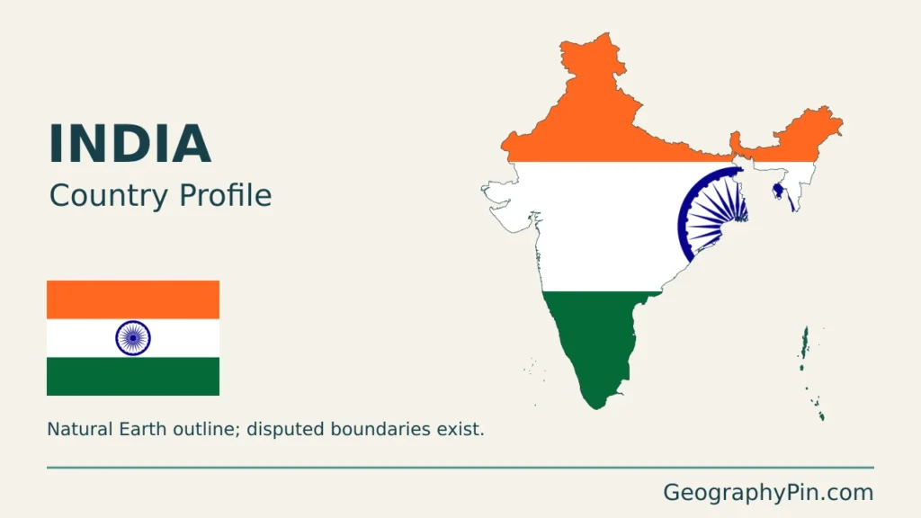
Map sources and scope: Original GeographyPin compositions use public-domain Natural Earth country and city geometry, its boundary-line dataset and actual georeferenced shaded relief. The main map uses a Lambert azimuthal equal-area projection centered at 22°N, 80°E. Islands retain their original positions in the main frame and appear again in separately framed, different-scale enlargements. Small islands and fine coastline details may be omitted by generalization.
Broad landscape labels locate regions rather than defining surveyed boundaries. Terrain shading is not an elevation-class or hazard map. Borders follow Natural Earth’s default boundary convention, not India’s official claim map. Kashmir and other India–Pakistan and India–China boundary sectors are disputed. Dashed lines reproduce the source categories for disputed, control, indefinite or indeterminate lines; they are not a current military-control survey. Natural Earth separately encodes Siachen Glacier, and retaining that source allocation does not imply a separate sovereign state. The artwork’s November 2026 date indicates preparation, not a fresh boundary survey.
The reported statistical area and the map are separate products with different territorial conventions. The UNData area should not be interpreted as a measurement of the Natural Earth outline shown here.
The cover uses an authentic Indian flag vector, scaled uniformly before decorative clipping, with a complete flag shown separately. GeographyPin branding identifies the original composition, not ownership of the public-domain geographic data.