Gadisar Lake brings Jaisalmer’s water history into view: a managed reservoir, a stone gateway and pavilions beside a desert city. Its significance lies not only in the reflections but in the relationship between rainfall, storage and urban life.
Gadisar Lake, also called Gadsisar, is a historic man-made reservoir on the southern side of Jaisalmer, Rajasthan, India. Associated with Maharawal Gadsi Singh, it helped meet the city’s water needs. Its gateway, steps and pavilions now make it an important place to understand Jaisalmer’s built water landscape.
How to use this article: Start with the lake and fort, follow water storage and supply, or explore the waterside architecture.
1. Where Is Gadisar Lake?
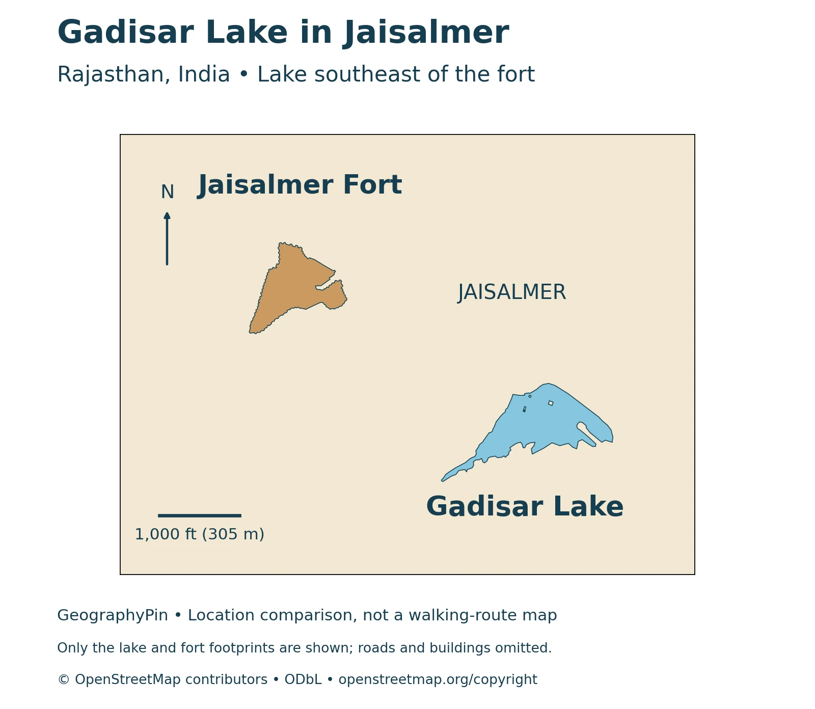
Gadisar Lake lies beside Jaisalmer in western Rajasthan, India. Also written Gadsisar, it occupies the southern to southeastern side of the historic city, outside the old fortified core. The lake and Jaisalmer Fort are separate places: the fort rises on its hill, while the reservoir occupies lower ground to its southeast.
The reservoir and the hilltop fort
A city-scale locator is more useful here than a map of Rajasthan alone. It shows how close the waterbody is to the built city while keeping the fort footprint distinct from the lake shore. Neither a straight line between them nor an apparent gap between buildings should be treated as a walking route.
Jaisalmer’s desert setting makes the reservoir especially significant. Rather than evidence of a large natural river running through the city, Gadisar represents a deliberate effort to retain water. Its architectural surroundings are part of that urban water landscape, not simply a collection of monuments beside an unrelated natural lake.
2. A Reservoir with a Layered History
Rajasthan Tourism associates Gadisar’s construction with Maharawal Gadsi Singh in the fourteenth century. Other heritage records describe an earlier origin or use a date around 1400. These accounts do not provide a consistent, precisely dated sequence of initial excavation, enlargement and rebuilding, so an exact foundation year is best treated cautiously.
Why the water-storage function matters
The central historical point is clearer than the competing dates: Gadisar was a managed reservoir serving Jaisalmer’s water needs. The Rajasthan urban-development project’s heritage assessment describes the town’s past dependence on the lake. Its importance therefore extends beyond the attractive waterside skyline.
The distinction between a lake and a managed reservoir also changes what to look for. The basin holds water, its edges provide access, and the structures around it show how water storage became part of civic and religious life. Construction and repair could occur at different times; an old reservoir need not have a single architectural date shared by every gateway, pavilion and step.
3. How Desert Water Storage Differs from Modern Supply
Historic descriptions of Gadisar emphasize the collection and retention of rainwater and surface inflow. Rain falling on a catchment does not all remain where it lands: some can run toward lower ground and accumulate in a basin. A reservoir makes that stored water available beyond the rainfall event itself.
Stored lake water is not the same as a piped supply
Three different questions matter: where water enters a lake, how much remains in storage, and whether that water is distributed for use. A reservoir’s historical role cannot answer all three questions about the present day.
| Question | What the evidence supports |
|---|---|
| Historic function | A managed reservoir associated with the city’s water needs |
| Traditional input | Rainfall and surface inflow collected in the basin |
| Modern supply role | A separate operational question; an August 2024 project plan stated that the lake was not then used for water supply, including potable supply |
| Water level today | Requires a recent observation, not an inference from a photograph or historical description |
The 2024 statement is dated project evidence, not a guarantee about every later management decision. Likewise, a lake containing water does not establish that the water is suitable for drinking. This article does not map an unverified canal connection or assume that a supplementing supply operates continuously.
Conserving a waterbody also involves the land that drains toward it. The visible shoreline is the edge of the water at one time; a catchment is the wider area contributing runoff. Those are different geographic boundaries, and the locator in this article does not claim to delineate the reservoir’s protected land or entire catchment.
4. Gateways, Pavilions and the Waterside Landscape
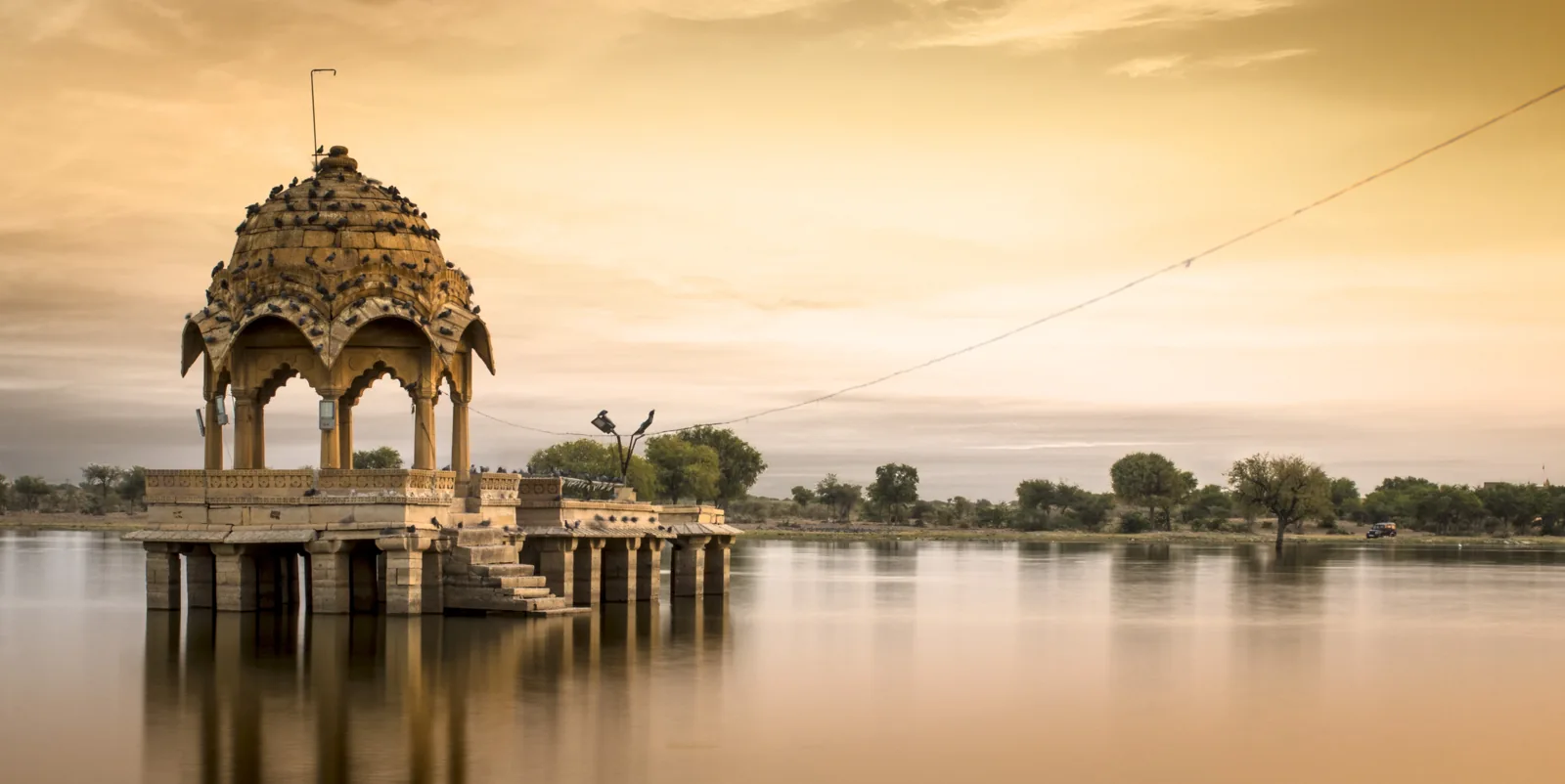
Tilon-ki-Pol is the prominent carved yellow-stone gateway associated with the approach to the lake. Around the water, steps and pavilions give the shoreline a built character. The IGNCA heritage inventory records chhatris and jharokhas among the architectural features.
Looking beyond the reflection
A chhatri is a canopied pavilion; a jharokha is a projecting window or balcony form. These details help explain why the shore reads as an architectural ensemble rather than an unmodified bank. Looking at the structures themselves, as well as their reflections, reveals the relationships between open water, sheltered spaces and approaches to the shore.
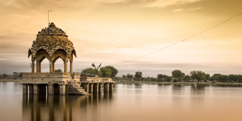
The photograph shows a pavilion beside Gadisar. The image was made with a long exposure, which can smooth the appearance of the water. It is an archival photograph, not evidence of the current water level, a present-day access route or permanently calm conditions.
Jaisalmer Fort belongs to UNESCO’s serial Hill Forts of Rajasthan World Heritage property. That designation concerns the listed fort components; it should not be casually transferred to every nearby attraction. Gadisar’s historical interest can be explained without calling the lake a separately inscribed UNESCO site.
5. Visiting with the Water Landscape in Mind
For a visit, distinguish the open waterside setting from individual buildings, steps and any commercial activities. Conditions and access can change independently: a view of the lake does not mean every pavilion or section of shoreline is open. Follow local signs and keep religious spaces separate from ordinary photographic viewpoints.
Where to check practical details
Rajasthan Tourism lists a Tourist Reception Centre near Gadisar Lake in Jaisalmer. Its official contact directory is a better starting point for current visitor information than an undated timetable copied between travel pages. Confirm any boat operation, charge or show locally rather than treating it as a permanent feature of the reservoir.
Use the locator to understand the relationship between lake and fort, then use an up-to-date street map for an actual route. Keep clear of unstable edges and do not infer water depth from color or reflections. A picturesque reservoir is still a working urban environment whose water, structures and public spaces need care.
What Did We Learn Today?
Gadisar is a historic managed reservoir, not simply a natural oasis beside Jaisalmer. Its storage function and waterside architecture belong to the same urban story. Historical water use, a dated modern supply statement and today’s conditions are separate questions, while the lake, its catchment and the nearby fort are distinct geographic features.
Sources & Data Notes
Official accounts differ on the reservoir’s origin date. This article attributes the Gadsi Singh association to Rajasthan Tourism rather than presenting a disputed foundation year as settled. The water-supply statement describes the August 2024 project document, not a current utility report. No unverified depth, water capacity, catchment boundary or canal route is supplied.
The map uses actual OpenStreetMap lake and fort footprints, not a legal boundary or a water-level survey. A source-comparison table substitutes for a water-supply diagram because a current engineered canal or pipe connection has not been independently verified. The real photograph has documented long-exposure and processing metadata; our changes are proportional resizing and WebP conversion only.
- Rajasthan Tourism: Gadisar’s association with Gadsi Singh and historic water needs
- Rajasthan urban-development project: environmental examination and heritage context
- August 2024 project plan: existing conditions and dated water-supply statement
- IGNCA heritage inventory: reservoir and architectural details
- UNESCO: Hill Forts of Rajasthan and the scope of the serial property
- Rajasthan Tourism: official visitor-information directory