Canada’s geography is a study in contrasts: a country spanning three ocean coasts, but with much of its population concentrated along its southern edge. Reading its map means looking beyond provincial boundaries to the mountains, lowlands, ancient rock and waterways that help explain where people live.
Canada occupies much of northern North America, between the Pacific, Atlantic and Arctic oceans. Ottawa is its capital. Its geography combines the Canadian Shield, western mountains, interior plains, eastern lowlands and Arctic islands. Much of its population lives in southern regions, where climate, farmland, transport routes and established cities support denser settlement.
How to use this article: Compare land and total area, understand the Shield and western mountains, or jump to the reasons for southern settlement.
1. Where Canada is and how to read the map
Canada lies north of the contiguous United States and east of Alaska. The Pacific faces its western coast, the Atlantic its eastern coast, and the Arctic Ocean its far north. The Arctic Archipelago is part of Canada, not a separate country; Greenland lies farther east across Arctic straits and bays.
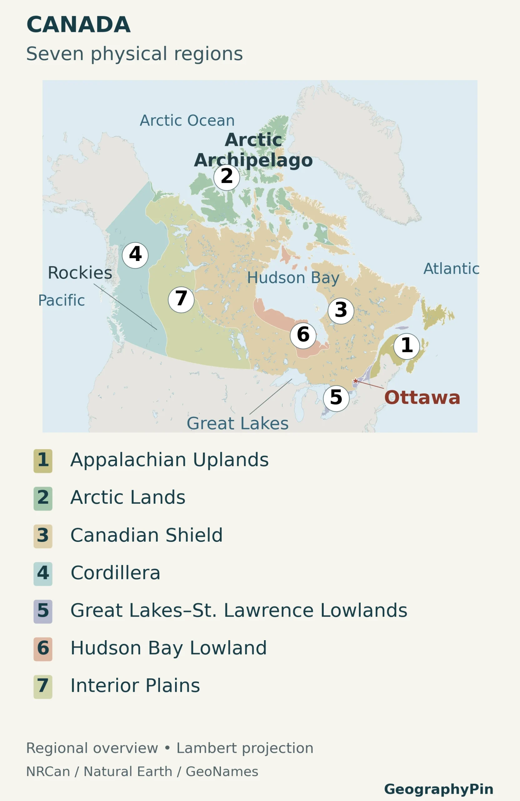
Start with Hudson Bay, the large indentation in the country’s north-central outline. The Canadian Shield extends around much of it, while the Cordillera forms the mountainous west. The Great Lakes and St. Lawrence lowlands occupy a much smaller part of the map, yet are central to understanding the country’s population.
Political and physical maps answer different questions. Provinces and territories show administration; physiographic regions group land by its geology and terrain. A province can contain several physical regions, and a physical region can cross provincial boundaries. Use the Canada provinces and territories map for the administrative picture.
2. Canada’s key facts, with dates and definitions
Population and area figures need different kinds of labels. A population estimate describes people at a particular date; an area total depends on whether inland water is included. The figures below keep those distinctions visible.
| Item | Reference |
|---|---|
| Capital and federal seat | Ottawa, Ontario |
| Population | 41,798,407, estimated for July 1, 2026; Statistics Canada release of September 23, 2026 |
| Total area | About 3,855,100 square miles (9,984,670 square kilometers), including freshwater |
| Land area | About 3,511,000 square miles (9,093,507 square kilometers) |
| Freshwater area | About 344,100 square miles (891,163 square kilometers) |
| Federal official languages | English and French; provincial and territorial language arrangements differ |
| Currency | Canadian dollar (CAD) |
| Administration | 10 provinces and 3 territories |
| Government | Federal parliamentary democracy and constitutional monarchy |
Land area is not the same as total area
The area figures use the Atlas of Canada land-and-freshwater series reproduced by Statistics Canada. They are not a new measurement for 2026. Rounded square-mile conversions are provided for comparison, while the source’s square-kilometer values are retained. Census land-area measures use different geographic methods and are not directly interchangeable with this series.
Likewise, the July 2026 population figure is an estimate, not the result of the 2026 Census. Statistics Canada identifies these estimates as preliminary and subject to revision. Census counts and population estimates should not be treated as interchangeable totals.
3. The landscapes that shape Canada
The Atlas of Canada distinguishes seven broad physiographic regions. These are a useful framework for reading the landscape, not seven separate climates or seven administrative divisions. The table identifies their geographic relationships rather than treating provincial borders as landform boundaries.
| Region | Where to look | Landscape |
|---|---|---|
| Canadian Shield | Around much of Hudson Bay, extending into eastern and northern Canada | Old bedrock, glacially shaped uplands and numerous lakes |
| Cordillera | Western Canada | Mountain ranges, plateaus and valleys; includes the Rockies |
| Interior Plains | Between the Shield and Cordillera | Plains extending from the southern Prairies into the north |
| Great Lakes–St. Lawrence Lowlands | Southern Ontario and southern Quebec | Low-lying terrain around major lakes and the St. Lawrence |
| Appalachian Uplands | Southeastern Canada | Older uplands, hills and coastal landscapes |
| Hudson Bay Lowland | Along parts of Hudson Bay and James Bay | Low-relief terrain with extensive wetlands |
| Arctic Lands | Parts of the far northern mainland and islands | Northern plains, lowlands and mountain terrain |
The Shield and the Rockies are different kinds of landscapes
The Canadian Shield is not a single mountain range. Its ancient bedrock includes igneous, metamorphic and sedimentary rocks, and its surface has been modified by erosion and glaciation. Exposed rock and thin deposits of glacial sediment are common. That helps explain why a lake-studded Shield landscape looks so different from a broad agricultural plain.
The Rockies, by contrast, are one mountain system within the larger western Cordillera. Calling every western Canadian mountain “the Rockies” erases the Coast Mountains and other ranges and plateaus. Moraine Lake offers a local example of Rocky Mountain scenery, but it does not represent all of western Canada.
Another distinction matters in the north: the Arctic Archipelago names a group of islands, while “Arctic Lands” is a physiographic classification. They are not interchangeable labels. Parts of the eastern Arctic islands belong to the Shield in the Atlas framework. The map’s region colors therefore describe terrain, not simply how far north a place lies.
4. Climate and water: why location matters
Latitude sets a broad north–south contrast, but oceans, elevation and distance inland modify it. A single national temperature average would conceal more than it explains.
- Southwestern Pacific coast: ocean influence moderates winter conditions. Around Vancouver and Victoria, winter rain is more common than snow.
- Interior and Prairies: continental conditions produce strong seasonal contrasts, and parts of the southern interior are relatively dry.
- Southern Ontario and Quebec: winters are cold, while summers can be warm or hot and humid.
- Far north: Arctic conditions combine long cold seasons with low precipitation in many areas. A cold landscape is not necessarily a snowy or wet one.
Mountains also make nearby places different. Pacific-facing slopes and interior basins do not receive the same moisture, while elevation changes temperature and snow conditions. These contrasts affect vegetation, water availability and the routes through which roads and settlements can expand.
Waterways provide another way to read the country. The Great Lakes–St. Lawrence system connects the southern interior to the Atlantic. The Mackenzie system carries water toward the Arctic, while rivers draining into Hudson Bay and James Bay organize much of the central landscape. Canada’s watersheds do not simply follow provincial borders.
Lake Superior belongs to the Great Lakes system; Hudson Bay is a saltwater marine basin. Their blue areas on a map should not be counted as the same type of water body. Nor does a large national freshwater inventory mean water is equally available everywhere: dry regions, distant supplies and water quality create local constraints.
5. Why Canadians are concentrated in the south
Why so many people live near the U.S. border
Several advantages overlap in southern Canada: comparatively favorable growing conditions, useful farmland in particular regions, navigable waterways, access to trade and generations of investment in towns and transport. Climate is part of the explanation, but it is not enough by itself. Established employment and infrastructure help population concentrations persist.
Statistics Canada’s analysis of the 2016 Census found that 66% of the population lived within about 62 miles (100 kilometers) of the southern Canada–U.S. border, in roughly 4% of the country’s territory. This is a dated measurement with a defined distance, not a claim about the exact proportion today. It is more useful than repeating an undated rule that almost everyone lives within an unspecified border strip.
The pattern is also uneven. Southern Ontario and Quebec form a major concentration around the Great Lakes and St. Lawrence, including Toronto and Montreal. Vancouver anchors a Pacific-coast concentration, while Winnipeg and Alberta’s cities show the importance of inland settlement. These are different urban settings, not a continuous line of equally dense cities from coast to coast.
Ottawa’s role is political rather than a claim to be the country’s largest city. It sits on the Ontario side of the Ottawa River, opposite Gatineau in Quebec. The Ottawa capital profile explains that setting in more detail.
Low population density in the north does not mean an empty or unused landscape. Communities, Indigenous homelands, travel routes and resource activities exist far beyond the southern urban concentrations. A population map describes the distribution of residents, not the cultural significance or ownership of land. Pond Inlet (Mittimatalik) on northern Baffin Island provides a community-scale example of those connections between settlement, land and sea.
6. Peoples, languages and government
English and French have equal official status in Canada’s federal institutions. That does not mean every Canadian speaks both, or that every province has the same language rules. New Brunswick’s English and French official-language status is separately protected in the Constitution; other provincial and territorial arrangements differ.
The 2021 Census reported that 18.0% of the population could converse in both English and French. French is especially prominent in Quebec, but French-speaking communities also exist elsewhere. English–French bilingualism is only one measure of language use: mother tongue, language spoken at home and knowledge of a language describe different things.
First Nations, Métis and Inuit are distinct Indigenous peoples, not interchangeable names for one population. The 2021 Census counted 1,807,250 Indigenous people in Canada. Its results also recorded more than 70 Indigenous languages. Those dated census findings should not be relabelled as 2026 counts or treated as a complete description of identities and communities.
Canada’s government combines federalism with a parliamentary system and a constitutional monarchy. The monarch is head of state; the prime minister leads the government. Parliament consists of the Crown, Senate and House of Commons. Federal, provincial and territorial institutions have different responsibilities, so a country-level description cannot substitute for the rules of a particular province or territory.
The distinction between provinces and territories is constitutional, not merely a difference in size. Provinces exercise powers under the Constitution, while territorial powers have been delegated through federal legislation. All three territories nevertheless have their own governments and legislatures.
7. How geography shapes the economy
Canada is not simply a resource economy spread across a large map. Services, including health care, finance, education, retail and government, account for a major part of economic activity. Manufacturing also matters, alongside agriculture, forestry, fisheries, mining and energy production.
The geographic connections are visible. Southern Ontario and Quebec combine population centers with manufacturing and transport infrastructure. Prairie agriculture and western energy production depend on different land and resource settings. Atlantic and Pacific ports connect inland producers and consumers with overseas routes. Resource communities can be far from the largest metropolitan centers.
The United States is central to Canada’s trading relationships, which gives southern transport links an importance that the national outline alone cannot show. But a map of resources is not a map of all jobs: urban services, manufacturing supply chains and transport networks connect places with very different landscapes.
Read the physical and human maps together. Mountains and ancient rock influence routes and land use; climate and water affect what can be grown and supplied; existing cities concentrate institutions and employment. None of those factors alone explains the whole country.
Frequently Asked Questions
Is all of Canada north of the 49th parallel?
No. Much of southern Ontario lies south of 49° north, as do other parts of eastern Canada. The 49th parallel forms a long western section of the Canada–U.S. boundary, not the entire international border.
Is the United States Canada’s only land neighbor?
Canada’s extensive mainland borders are with the United States. A 2022 agreement with the Kingdom of Denmark, together with Greenland, also established a land boundary on Tartupaluk, or Hans Island, between Canada and Greenland. That small Arctic boundary is separate from the much longer U.S. border.
Does Canada’s large area include the Great Lakes?
The total-area figure used here includes Canada’s freshwater area, including its portions of shared lakes. It does not mean that all five Great Lakes are entirely Canadian. Land-only comparisons must use a separate land-area measure.
What Did We Learn Today?
Canada’s outline is only the beginning of its geography. The Shield, Cordillera, plains, lowlands and Arctic regions explain contrasting landscapes, while waterways, climate and established transport routes help explain southern settlement. Provincial boundaries answer an administrative question, not a physical one. Keeping population dates, land-and-water definitions and language jurisdictions separate makes the country easier to understand without flattening its regional differences.
Sources & Data Notes
The national population figure is a preliminary July 1, 2026 estimate; language and Indigenous-population figures refer to the 2021 Census, and the measured border-distance example refers to 2016. Area figures use the Atlas land-and-freshwater convention, with square-mile conversions rounded. Physical regions follow the Atlas of Canada classification rather than provincial boundaries. These datasets answer different questions and should not be combined as though they describe one census date.
- Statistics Canada: population estimates, age and gender, 2026
- Statistics Canada: land and freshwater area, using Atlas of Canada figures
- Natural Resources Canada: Physiographic Regions of Canada
- Ontario Geological Survey: bedrock and surficial geology
- Government of Canada: land, climate and settlement regions
- Environment and Climate Change Canada: Hydrology of Canada
- Environment and Climate Change Canada: Water in Canada
- Statistics Canada: 2016 Census population distribution
- Statistics Canada: languages, 2021 Census
- Statistics Canada: Indigenous peoples, 2021 Census
- Department of Justice: official-language provisions
- Government of Canada: Democracy in Canada
- Intergovernmental Affairs: provinces and territories
- Discover Canada: economic sectors and trading relationships
- Global Affairs Canada: the Tartupaluk/Hans Island boundary agreement
- International Boundary Commission: the western 49th-parallel boundary
- Government of Canada: Canadian currency
- Discover Canada: regional geographic context
Map sources and method: Original GeographyPin cartography uses Natural Resources Canada’s physiographic-region data, public-domain Natural Earth coastlines and lakes, and GeoNames’ Ottawa location (CC BY 4.0). Region polygons are clipped to Natural Earth’s generalized Canada land outline to remove small shoreline mismatches between datasets. The layers use the same Canada Atlas Lambert projection. Numbers and colors identify physical regions, not rankings or elevation. Generalized coastlines are suitable for country-scale orientation, not precise boundary measurement. Contains information licensed under the Open Government Licence – Canada.
Featured illustration: Original GeographyPin graphic combining the public-domain Natural Earth outline of Canada with a public-domain Canadian flag graphic from Wikimedia Commons. The flag motif is fitted within the country outline as an editorial illustration, not a representation of the official flag’s rectangular proportions.