A blue-green lake beneath a wall of peaks can seem easy to understand from a photograph, yet its color, basin and access each tell a different story. Reading Moraine Lake’s landscape means connecting glacial sediment and fallen rock with the practical geography of its mountain setting.
Moraine Lake is a glacier-fed mountain lake in Banff National Park, Alberta, Canada, set in the Valley of the Ten Peaks. It is separate from nearby Lake Louise. Fine glacial sediment helps produce its turquoise appearance, while its landscape combines a glacier-eroded basin with a natural rockslide barrier.
How to use this article: Read the dated lake measurements, follow the rock-flour explanation, or compare Moraine Lake and Lake Louise.
1. Where Is Moraine Lake in Canada?
Moraine Lake lies in Banff National Park, Alberta, in the Canadian Rocky Mountains. Its immediate setting is the Valley of the Ten Peaks, south of the community of Lake Louise. The village, Lake Louise itself and Moraine Lake are three distinct places, even though visitor information often groups them together.
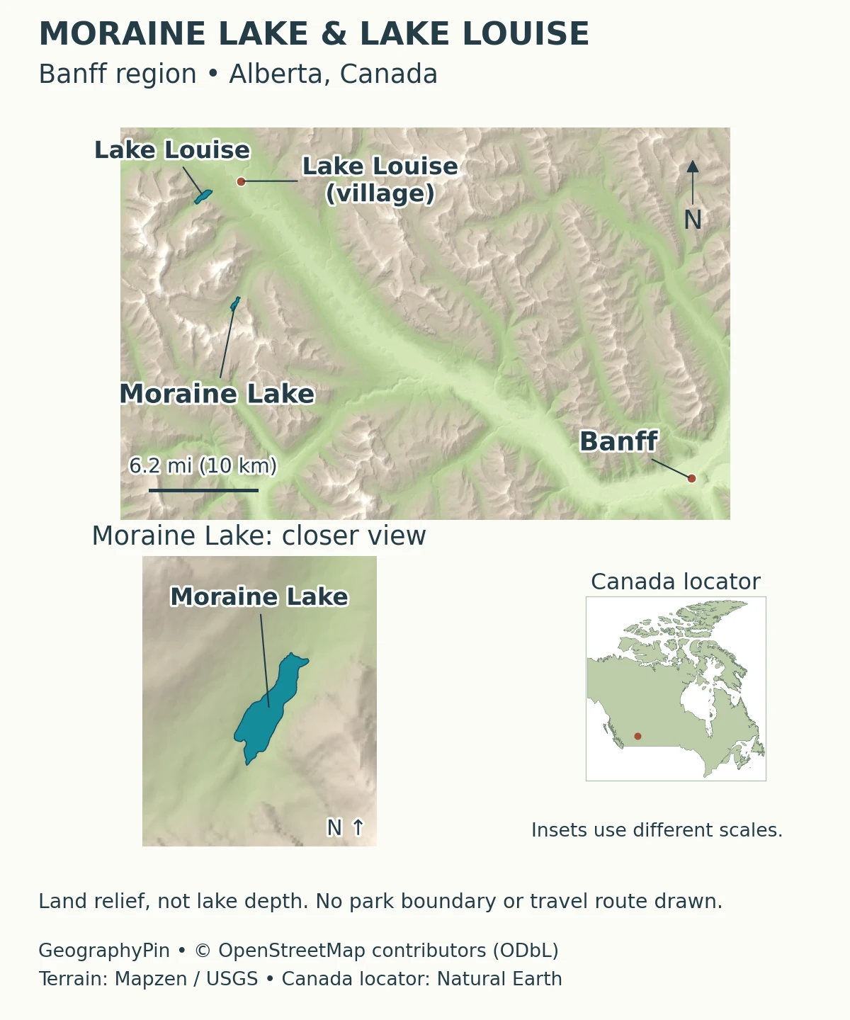
Read the region at two scales
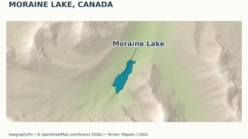
At the national scale, the lake belongs to western Canada, not the Great Lakes region of central and eastern North America. At the local scale, it is a small mountain basin surrounded by steep terrain. A provincial or country locator explains the first relationship; the shoreline map explains the second.
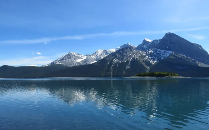
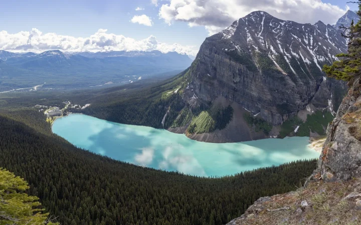
The Valley of the Ten Peaks is the mountain setting behind the celebrated lake views, not the name of another lake. A photograph from the Rockpile looks into that landscape, while a regional map helps distinguish the neighboring valleys and the separate Lake Louise destination.
2. Lake Facts: What the Measurements Actually Describe
A dated scientific reference, not a live water-level reading
A detailed scientific reference is Mayhood and Anderson’s Limnological Survey of the Lake Louise Area, published in 1976 by the Canadian Wildlife Service for Parks Canada. Its Moraine Lake profile includes a bathymetric survey and the following measurements. The date is important: these are historical reported values, not a new survey of current conditions.
| Measure | Reported value | Meaning and limitation |
|---|---|---|
| Mapped surface elevation | About 6,190 feet (1,887 meters) | An elevation taken from topographic mapping, not a modern surveyed water-level benchmark. |
| Surface area | About 102 acres (41.3 hectares) | The lake area reported in the historical survey. |
| Maximum depth | About 75 feet (22.9 meters) | The deepest sounding reported in that study. |
| Mean depth | About 31 feet (9.6 meters) | Average basin depth, not the depth at every shore. |
| Length | About 0.94 mile (1,505 meters) | Lake length, not a trail distance. |
The report’s methods distinguish map-derived elevations from water-depth measurements made using an echo sounder. Decimal places in a reproduced table should not be mistaken for centimeter-level certainty about the present lake surface.
Water level also changes with the season. A lake’s surface area, shoreline position and water depth are related to its level, whereas its mapped mountain setting does not change in the same way. Differences between unsourced web summaries cannot automatically be interpreted as proof that the lake has grown, shrunk or become shallower.
3. A Glacial Valley With a Rockslide Barrier
The name is not a complete geological explanation
A moraine is material deposited by a glacier, but a place called Moraine Lake should not automatically be classified as a simple moraine-dammed lake. The 1976 scientific report describes its deepest part as a rock basin eroded by glacial action and enlarged by a rockslide dam, citing Kucera’s work on the mountain landscape.
These processes play different roles. Glacial erosion shapes a depression in bedrock. A later accumulation of fallen rock can obstruct drainage and retain more water. Calling the whole setting glacial is compatible with identifying rockslide debris at the barrier; the two explanations are not mutually exclusive.
The local tourism association also describes the rockslide deposit near the Rockpile as the natural dam. Its trail description places the Rockpile beside the lake’s outlet area, where a short climb provides the familiar view across the water. That visible pile is a landform, not an artificial dam built for a reservoir.
The distinction is useful beyond this one lake, as our lake explainer discusses. A lake’s water source, the origin of its basin and the material blocking its outlet are separate questions. “Glacier-fed” describes a supply of water; it does not, by itself, identify the type of barrier or establish that a glacier still touches the shoreline.
4. Why Moraine Lake Looks Turquoise
Fine mineral particles change how light travels through the water
The turquoise appearance is linked to rock flour, extremely fine mineral sediment produced as glaciers grind rock. Meltwater carries this material into downstream water bodies, where suspended particles scatter light. University of Alberta limnologist Rolf Vinebrooke explains this mechanism in the context of glacier-fed lakes in the Canadian Rockies.
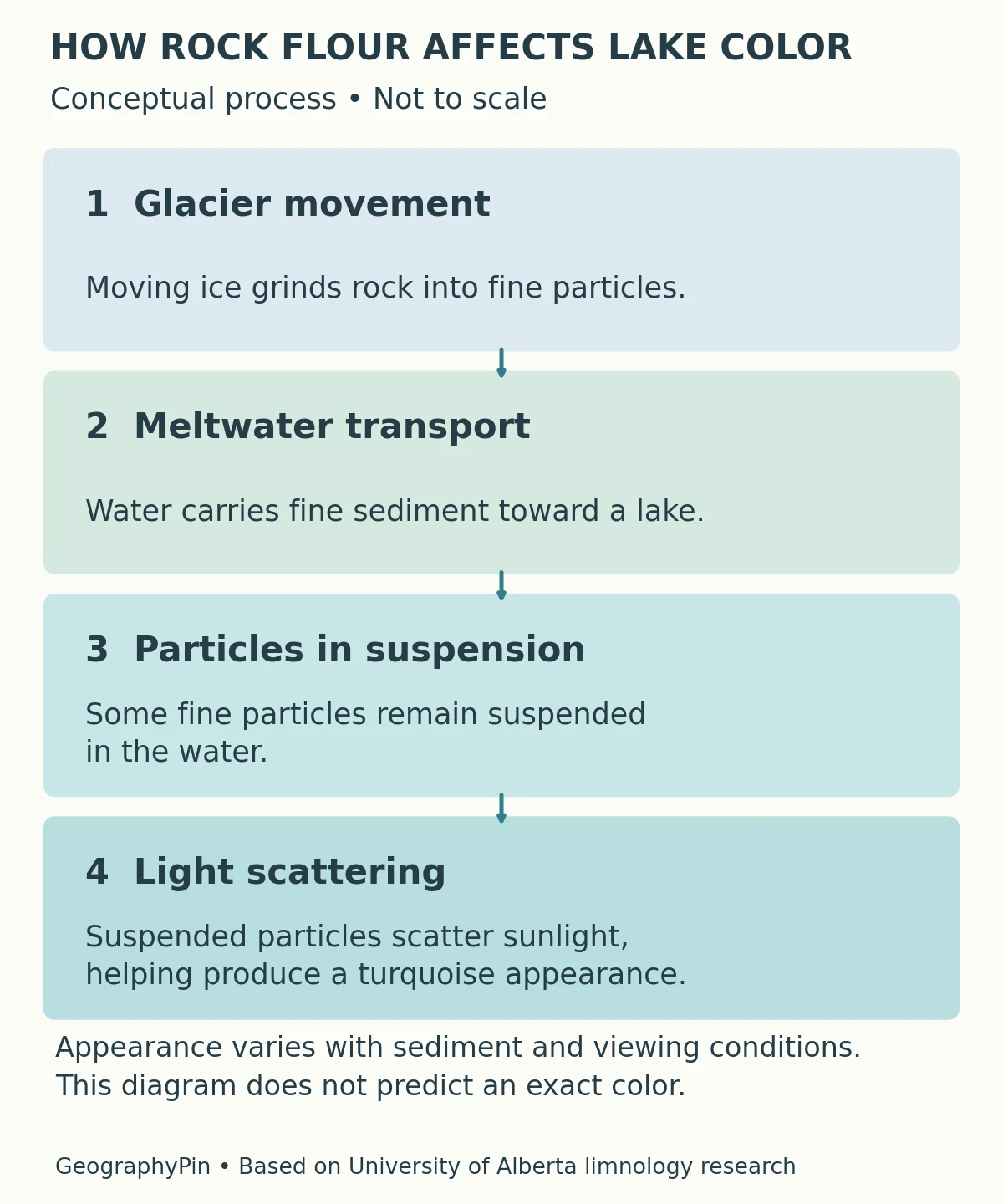
This is not the same as adding a blue dye. The particles interact with light inside the water, while the surface also reflects the sky and surrounding mountains. The resulting appearance depends on the light, the viewing direction and the water’s condition; one photograph cannot guarantee an identical shade during every visit.
Nor does turquoise mean the water is free of particles. In glacier-fed lakes, the fine suspended material is part of the reason the water can look milky or luminous. Very clear blue water and sediment-rich turquoise water can therefore have different optical explanations.
The same research group describes regional examples of lakes becoming clearer as glacier-derived sediment supplies diminish. That finding should not be converted into a specific forecast for when Moraine Lake will change color. A general process and a lake-specific measured trend require different evidence.
5. Moraine Lake Versus Lake Louise
Nearby destinations, different basins
Moraine Lake and Lake Louise are not alternate names for the same water body. Both are in Banff National Park and both are associated with glacial mountain scenery, but Moraine Lake sits in the Valley of the Ten Peaks, while Lake Louise occupies its own valley. The community named Lake Louise is a third geographic reference point.
| Place | What the name identifies |
|---|---|
| Moraine Lake | The lake in the Valley of the Ten Peaks, reached via Moraine Lake Road during the permitted season. |
| Lake Louise, the lake | A separate lake and lakeshore destination, not an extension of Moraine Lake. |
| Lake Louise, the community | The village and service area, distinct from either lakeshore. |
Parks Canada’s shuttle information includes a Lake Connector between the two lakes during its operating season. That is a transport link, not a natural water connection. A ticket or itinerary grouping both places does not make them one basin.
For photographs, look beyond the blue water. The arrangement of peaks, the shape of the shore and the viewpoint are more reliable identifying clues than color alone. For travel, check the exact destination named on the booking rather than assuming any Lake Louise service reaches Moraine Lake.
6. Access, Seasons and Responsible Visiting
A year-round vehicle restriction is different from a seasonal closure
Under Parks Canada’s published 2026 arrangements, Moraine Lake Road is closed to personal vehicles year-round. Authorized transport includes Parks Canada shuttles and licensed commercial operators; the park also lists an exception for registered Moraine Lake Lodge guests. Check official eligibility and transport information rather than assuming a private car can proceed because a road is physically open.
The seasonal operating window is a separate matter. Parks Canada listed its Moraine Lake shuttle season as June 1–October 12 in 2026, weather permitting. Those dates describe that season, not a promise for 2027 or every future year. Reservations and park admission are separate requirements, and current schedules belong on the official Parks Canada access page.
Winter changes the problem from summer congestion to mountain conditions. Parks Canada warns of avalanche exposure along the approach. A road closed for the season is not an invitation to treat the full approach as an easy winter walk. Consult current park conditions and closures before making any route decision.
What Did We Learn Today?
Moraine Lake is a distinct Banff lake, not another name for Lake Louise. Its glacial setting, rockslide barrier and sediment-rich turquoise water answer different geographic questions. Historical measurements need dates, photographs need context, and a year-round restriction on personal vehicles must be distinguished from the seasonal operating window of authorized transport.
Sources & Data Notes
The lake measurements come from a scientific report published in 1976, not a new survey of present conditions. Its elevation was taken from topographic mapping and its depths measured by echo sounding; unit conversions are rounded. Transport dates cited here describe 2026 arrangements and are not guarantees for later seasons.
- Mayhood and Anderson (1976): Limnological Survey of the Lake Louise Area, Part 2. Canadian Wildlife Service report prepared for Parks Canada, preserved by an independent archival website. Printed page 157 supplies historical Moraine Lake measurements and basin interpretation; methods distinguish mapped elevations from echo-sounded depths. Author-listed DOI: 10.13140/2.1.3848.4802.
- Author’s Freshwater Research library. Verifies the 1976 report’s authorship, title and institutional origin.
- University of Alberta (2021): glacial sediment and lake color. Limnologist Rolf Vinebrooke explains light scattering and regional clarification research; no date-specific Moraine Lake color forecast is implied.
- Banff & Lake Louise Tourism: lakes and the Rockpile. Local description of the rockslide deposit and viewpoint.
- Parks Canada: visiting Lake Louise and Moraine Lake. 2026 seasonal transport arrangements and year-round personal-vehicle restriction; consult for later seasons.
- Parks Canada: current conditions. Seasonal road closures and mountain-condition warnings.
- Parks Canada (2025): Lake Louise area visitor map. Official regional context and separate lakeshore destinations.
Original cartography: GeographyPin. Lake outlines and settlement positions: © OpenStreetMap contributors (ODbL). Actual Moraine Lake and Lake Louise outlines are preserved, with the village of Lake Louise marked separately. Terrain: historical Mapzen elevation tiles; global terrain data courtesy of the U.S. Geological Survey. Exact per-tile component lineage was not independently resolved; see source attribution. Canada locator: Natural Earth, public domain. Insets use different scales. No park boundary, glacier extent, travel route or lake bathymetry is drawn. The rock-flour diagram explains a general process and is not a measured cross-section, optical spectrum or future color forecast.