An island and an island country are not the same thing. Some countries spread across hundreds of islands, while others share one island with a neighbor. A useful world list therefore needs a rule for countries, continents and territories before it needs a total.
An island country has its national territory on one or more islands, including parts of shared islands. This list identifies 46 UN member states under a stated geographic rule: continental Australia is excluded, separately administered dependencies are treated separately, and Antarctic claims are outside the comparison. Broader definitions can produce different totals.
Find the distinction you need: Start with the counting rule, use the numbered country lists, compare shared islands, or check excluded and special cases.
1. What counts as an island country?
The rule behind the 46-country list
Begin with the UN member-state list, then ask whether the country’s national territory lies entirely on islands rather than a continental mainland. An island is a landmass surrounded by water; the political boundary of a country is a different kind of line. A country can occupy a whole island, several islands, or part of an island. Having a land border does not disqualify it.
For this comparison, Australia is treated as a continent, not an island. Separately administered dependencies are considered separately from the country responsible for them. Associated states are excluded from this list solely when they are not UN members. Antarctic territorial claims are outside the comparison. These choices are part of the method, not facts that every other list must adopt.
The result is 46 qualifying UN members, using membership and naming checked in November 2026. It is GeographyPin’s rule-based enumeration, not an official UN category called “the 46 island countries.” The UN supplies the membership baseline; the geographic filter supplies this list.
Two tests prevent common mistakes: an island belonging to a mainland country is not automatically a country, and a country that owns many islands does not automatically have all its territory on islands. France, Denmark and Malaysia therefore cannot be included merely because they have important island regions.
2. Island countries: maps and complete list
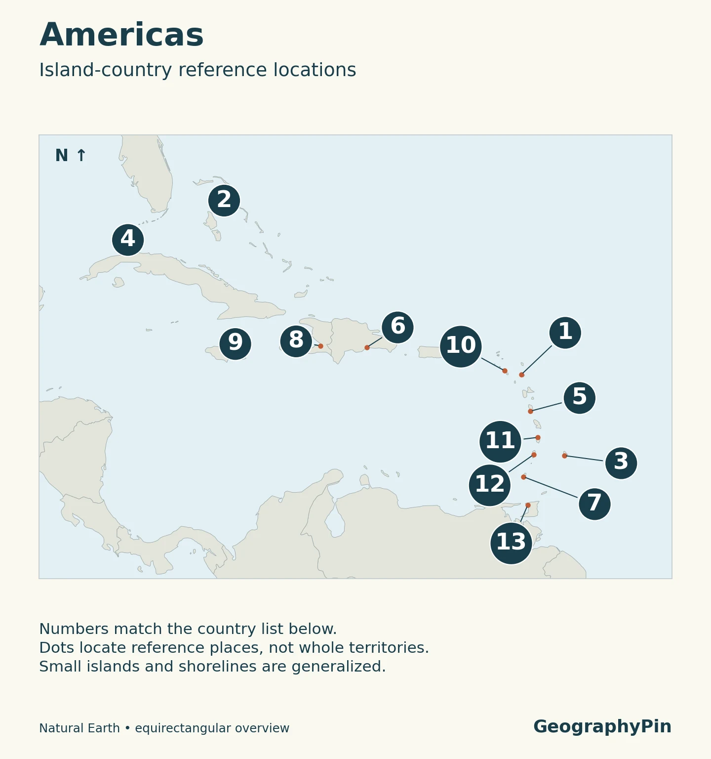
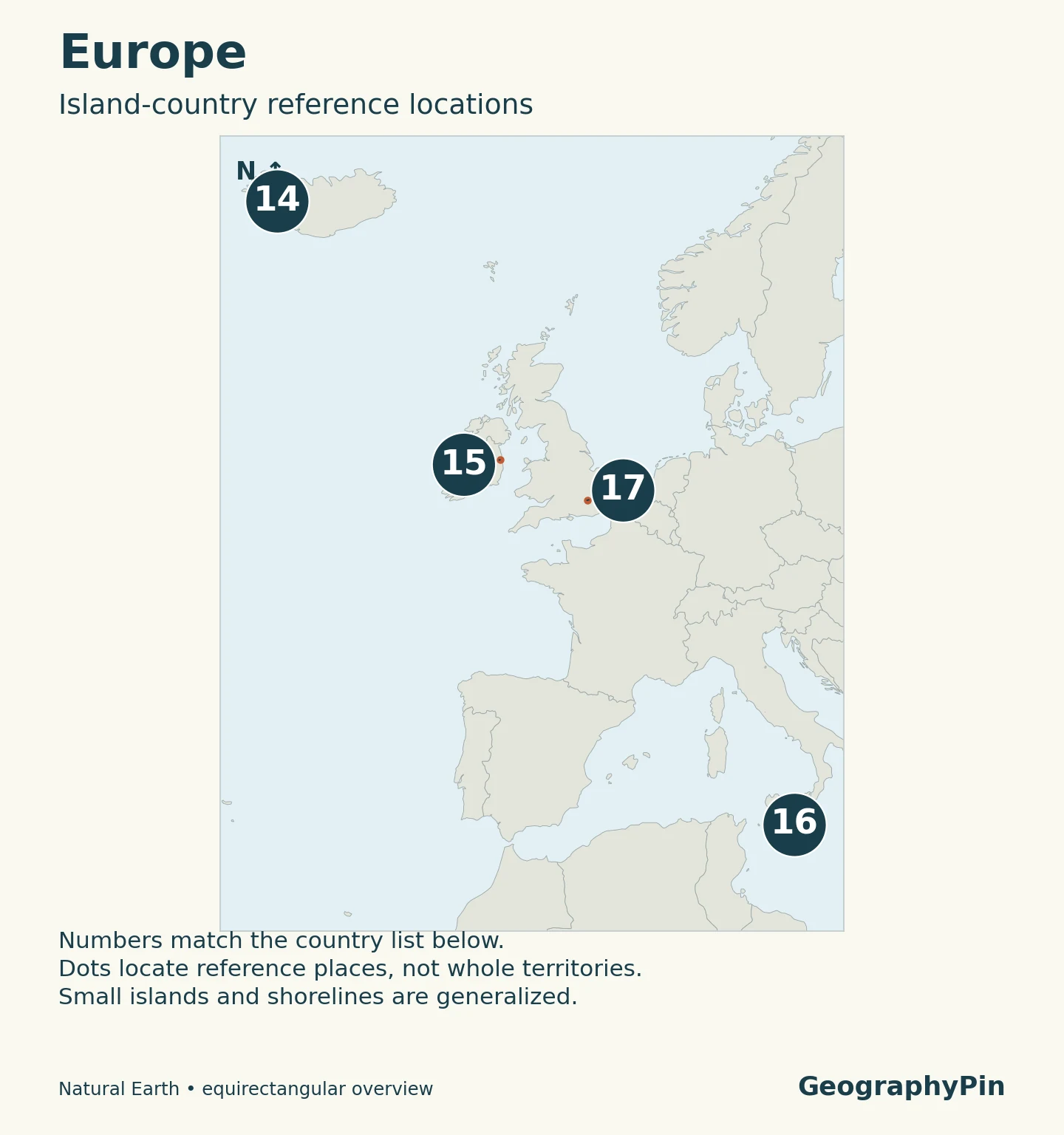
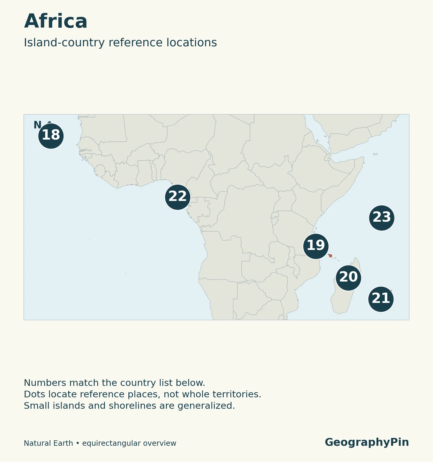
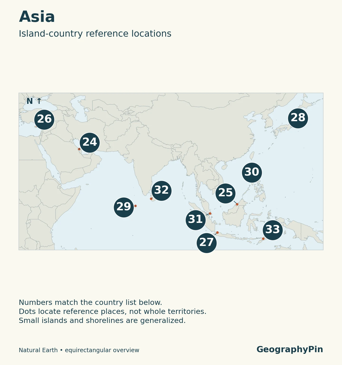
Match each map number to the country below it
The regional lists use UN M49 geographic groupings: 13 countries in the Americas, four in Europe, six in Africa, ten in Asia and 13 in Oceania. Cyprus is grouped with Asia here; other geographic and cultural conventions may place it differently. Regional grouping changes the arrangement, not the total.
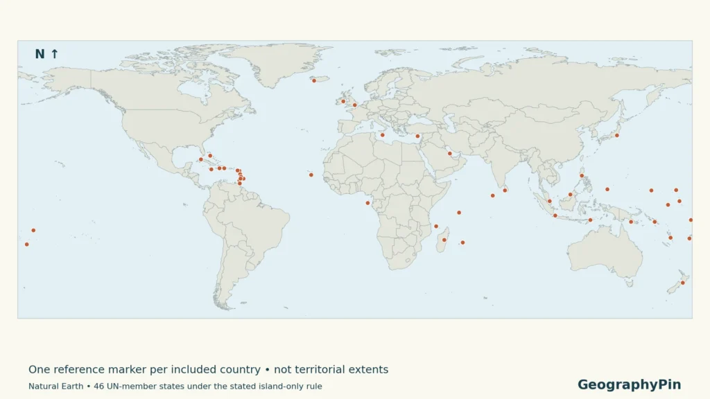
Each number identifies one country, not one island. The maps are locators rather than maps of maritime rights or disputed territorial claims. Small-island symbols make places visible without pretending that the symbol shows their true size.
Read the map and table together. Find a numbered marker, then use the same number in the table immediately below it. The island-setting column explains the geographic reason for inclusion; it does not list every offshore island or territorial claim. Numbers are reference identifiers, not rankings by area, population or importance.
The regional maps also use different viewing windows. An island that looks large in a regional close-up is not necessarily larger than an island shown in a wider Pacific view. For comparisons of national area, a separate consistently defined area dataset would be needed rather than measuring these illustrations.
Americas
| Map number | Country | Island setting |
|---|---|---|
| 1 | Antigua and Barbuda | Antigua, Barbuda and smaller islands |
| 2 | Bahamas | Atlantic archipelago north of the Caribbean |
| 3 | Barbados | Island east of the main Lesser Antilles arc |
| 4 | Cuba | Cuba and surrounding islands |
| 5 | Dominica | Lesser Antilles |
| 6 | Dominican Republic | Eastern Hispaniola and offshore islands |
| 7 | Grenada | Grenada and southern Grenadines |
| 8 | Haiti | Western Hispaniola and offshore islands |
| 9 | Jamaica | Jamaica and smaller islands |
| 10 | Saint Kitts and Nevis | The two named main islands |
| 11 | Saint Lucia | Lesser Antilles |
| 12 | Saint Vincent and the Grenadines | Saint Vincent and northern Grenadines |
| 13 | Trinidad and Tobago | The two main islands and smaller islands |
Europe
| Map number | Country | Island setting |
|---|---|---|
| 14 | Iceland | North Atlantic island and smaller islands |
| 15 | Ireland | Most of the island of Ireland |
| 16 | Malta | Mediterranean archipelago |
| 17 | United Kingdom | Great Britain, Northern Ireland and smaller islands |
Africa
| Map number | Country | Island setting |
|---|---|---|
| 18 | Cabo Verde | Atlantic archipelago west of Africa |
| 19 | Comoros | Western Indian Ocean archipelago |
| 20 | Madagascar | Madagascar and surrounding islands |
| 21 | Mauritius | Mauritius, Rodrigues and other islands |
| 22 | São Tomé and Príncipe | Gulf of Guinea islands |
| 23 | Seychelles | Western Indian Ocean archipelago |
Asia
| Map number | Country | Island setting |
|---|---|---|
| 24 | Bahrain | Persian Gulf archipelago |
| 25 | Brunei Darussalam | Part of Borneo and offshore islands |
| 26 | Cyprus | Republic of Cyprus; see status note |
| 27 | Indonesia | Archipelago including parts of shared islands |
| 28 | Japan | East Asian archipelago |
| 29 | Maldives | Indian Ocean atolls |
| 30 | Philippines | Southeast Asian archipelago |
| 31 | Singapore | Main island and smaller islands |
| 32 | Sri Lanka | Sri Lanka and smaller islands |
| 33 | Timor-Leste | Eastern Timor, Oecussi and offshore islands |
Oceania
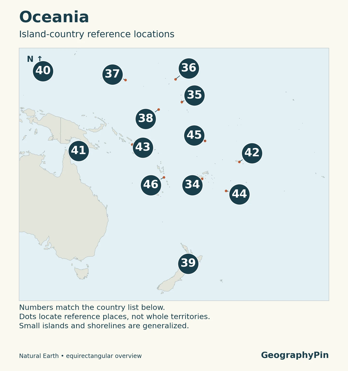
| Map number | Country | Island setting |
|---|---|---|
| 34 | Fiji | South Pacific archipelago |
| 35 | Kiribati | Gilbert, Phoenix and Line island groups |
| 36 | Marshall Islands | Micronesian atolls and islands |
| 37 | Micronesia (Federated States of) | Western Pacific island groups |
| 38 | Naoero (formerly Nauru) | Single main Pacific island |
| 39 | New Zealand | North Island, South Island and smaller islands |
| 40 | Palau | Western Pacific archipelago |
| 41 | Papua New Guinea | Eastern New Guinea and offshore islands |
| 42 | Samoa | South Pacific islands |
| 43 | Solomon Islands | Southwestern Pacific archipelago |
| 44 | Tonga | South Pacific archipelago |
| 45 | Tuvalu | Pacific atolls and reef islands |
| 46 | Vanuatu | Southwestern Pacific archipelago |
“Naoero (formerly Nauru)” follows the current UN member name while retaining the familiar former name. The UN records notification of the change on June 26, 2026; this does not represent a new country or an extra entry.
3. Countries that share an island
A land border can run across an island
Ireland and the United Kingdom both qualify, even though Northern Ireland and the Republic of Ireland share a land boundary. Great Britain is an island; the United Kingdom is a country whose territory also includes Northern Ireland and smaller islands. Those names are not interchangeable.
Haiti and the Dominican Republic share Hispaniola. Indonesia and Papua New Guinea share New Guinea. Indonesia and Timor-Leste share Timor, although Timor-Leste also has the separated Oecussi coastal exclave and offshore islands. A state does not need to occupy the entire landmass to be an island country.
Borneo provides the most useful counterexample. Brunei and Indonesia qualify under this rule, but Malaysia does not: Malaysia also has territory on the Malay Peninsula, part of mainland Asia. All three have territory on Borneo, yet only two belong in this island-only list.
The distinction is between the country’s complete geographic footprint and the particular island being discussed. Looking only at a capital city, one border segment or the largest island can produce the wrong classification.
4. Archipelagos: one country, many islands
An archipelago is a group of islands. It is a physical-geographic description, not a promise that every island in the group belongs to one country. Conversely, a country may include several island groups separated by large stretches of ocean.
Indonesia, Japan and the Philippines illustrate why counting countries is different from counting islands. Each receives one row here, regardless of how many islands a national inventory recognizes. Island totals also depend on survey methods and definitions. The country total is therefore independent of changes in island inventories.
The same principle applies to smaller states. Malta is an archipelago rather than just the main island of Malta, and the Maldives extends through a chain of atolls. Seychelles and Vanuatu are each single countries made up of multiple islands, not collections of independent countries.
There is also a legal distinction. “Archipelagic State” has a specific meaning in the UN Convention on the Law of the Sea, with associated rules about baselines and waters. This article uses ordinary geographic language and does not assign that legal status to every country with several islands.
5. Borderline cases and territorial status
Why some familiar places are outside the list
| Place | Decision | Reason |
|---|---|---|
| Australia | Excluded | Continental landmass under this article’s stated convention. |
| Malaysia and Equatorial Guinea | Excluded | Both include continental mainland territory. |
| Greenland and Puerto Rico | Not separate entries | Neither is a separate UN member state. |
| Cook Islands and Niue | Outside UN-member scope | Self-governing states in free association with New Zealand; not simply ordinary dependencies. |
| Taiwan | Outside UN-member scope | Not separately listed as a UN member; the filter does not settle wider recognition questions. |
| United Kingdom | Included | The UK itself is distinguished from separately administered overseas territories such as Gibraltar. |
| Republic of Cyprus | Included once | UN member; inclusion does not imply control of the entire island. |
Australia is sometimes described as an “island continent.” Excluding it here is therefore an explicit convention, not a claim that the phrase is impossible. A list that includes Australia can be coherent, but it should explain that choice rather than silently mixing continents and islands.
The Cook Islands and Niue are especially important exceptions to a simple country-versus-dependency split. New Zealand’s foreign ministry describes them as self-governing states in free association. Their omission follows the UN-membership boundary used here, not a claim that they lack their own international standing.
Cyprus requires care in both text and maps. The Republic of Cyprus is counted once; the island’s divided administration and the British Sovereign Base Areas mean that coloring the entire island as uniformly administered by that republic would be misleading. A locator point avoids making that territorial claim.
Finally, Small Island Developing States (SIDS) is a development grouping, not a synonym for this list. UN SIDS materials include mainland countries such as Belize, Guyana and Suriname. Neither an island’s size nor a country’s income level determines inclusion here.
Frequently Asked Questions
Are island countries necessarily small or tropical?
No. Madagascar and Japan show that island countries can be extensive, while Iceland demonstrates that they need not be tropical. Size and climate are separate from the geographic rule used in this list.
What Did We Learn Today?
Island countries can occupy shared islands or whole archipelagos. The 46 entries here follow a transparent UN-member-based rule, with Australia treated as continental and separate territories handled separately. The useful answer is not just the total: it is knowing why Brunei qualifies, Malaysia does not, and the Cook Islands and Niue need a different explanation from ordinary dependencies.
Sources & Data Notes
The list is an editorial geographic classification of UN members, not a UN designation. It excludes Antarctic claims from the comparison without making a judgment about those claims. Country names and regional grouping follow the cited UN references; familiar former names are retained where useful.
- Government of Malaysia: Peninsular Malaysia and Malaysian Borneo.
- UN Geospatial: Equatorial Guinea: Mainland Río Muni and offshore islands.
- UK Parliament: Sovereign Base Areas: Status of the two British Sovereign Base Areas on Cyprus.
- EU withdrawal agreement: Cyprus protocol: See Cyprus protocol on sovereign bases and areas without effective government control.
- UN current members: Membership baseline, checked November 2026; not an official island-country classification.
- UN M49: Regional organization, including Cyprus in Western Asia; country-or-area entries are not themselves a sovereignty test.
- UN: Naoero: Current name and June 26, 2026 notification.
- WIPO naming circular: Independent institutional confirmation of the Naoero short name, September 2, 2026.
- Geoscience Australia: Continental mainland and island distinction.
- Brunei Ministry of Foreign Affairs: Brunei’s Borneo location.
- Government of Timor-Leste: Eastern Timor, Oecussi and offshore islands.
- New Zealand MFAT: Cook Islands: Self-governing state in free association.
- New Zealand MFAT: Niue: Self-government and free association.
- UK Cabinet Office: Amber Book appendices: Appendix H distinguishes overseas territories from the UK.
- UN DESA: Small Island Developing States: Development grouping distinct from the geographic filter.
- UN Convention on the Law of the Sea, Part IV: Article 46 and the legal meaning of archipelagic State.
Map method: Original GeographyPin maps use Natural Earth public-domain country outlines and populated-place data. Markers locate reference places, not country centers or a verified list of current capitals; Naoero uses the source country-label point. North is up. Broad equirectangular views and generalized coastlines are for orientation, not distance measurement. Basemap borders follow the source’s de facto representation and do not endorse territorial claims. One marker cannot display every island in an archipelago; some markers overlap in the world overview.