Vanuatu is an island country in the southwestern Pacific, east of Australia and west of Fiji. Its elongated, broadly Y-shaped archipelago combines mountainous islands, active volcanoes and raised coral landscapes. Port Vila, the capital, is on Efate. Ocean distances, contrasting island terrain and exposure to several kinds of natural hazard help explain its settlement and transport geography.
A map of Vanuatu is not a map of one large island surrounded by a few smaller ones. The country extends along a chain with distinct northern, central and southern landscapes. Espiritu Santo, Efate and Tanna are useful starting points, but none represents every island.
Begin with the island locator, then compare it with the elevation map of Tanna. The first shows the archipelago’s arrangement; the second reveals how much terrain can vary within a single island. The photograph of Yasur records one volcanic site, not conditions throughout Vanuatu.
How to use this article: Explore island counts and territorial scope, different area figures and how to read Tanna’s map and photograph.
1. Where is Vanuatu?
Vanuatu lies in Melanesia, in the southwestern Pacific Ocean. The Solomon Islands are to its north, New Caledonia to its southwest and Fiji farther east. Australia lies west of the archipelago, across a substantial stretch of sea. Vanuatu has no land border with another country.
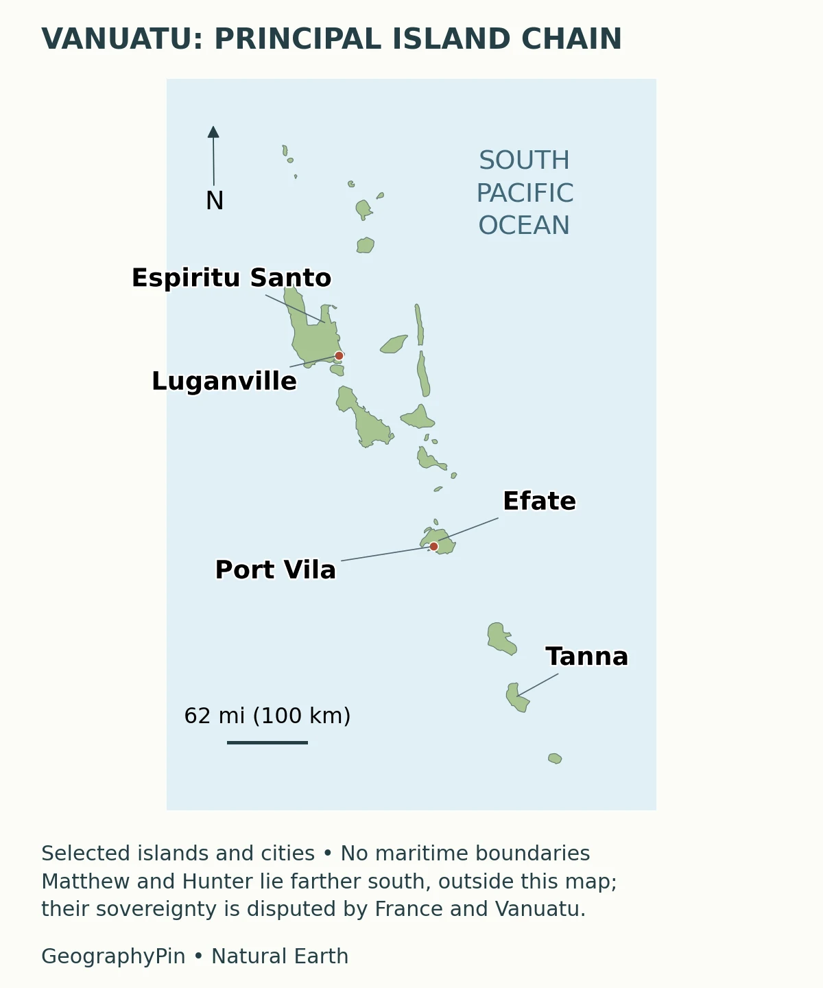
The familiar Y-shaped description is a useful first impression of the island arrangement, not a precise geometric boundary. Individual islands differ greatly in size, height and distance from their neighbors. The sea between them is part of everyday geographic connection, but it should not be counted as dry land.
Three names make the map easier to read. Espiritu Santo is the largest island and contains Luganville. Efate contains Port Vila, the national capital. Tanna, farther south, contains Yasur volcano. A description of Port Vila therefore concerns a city on Efate, not a separate island or the whole country. For comparison with other national capitals, see our world capital cities reference.
Island counts and territorial scope
Official descriptions commonly give 83 islands, but territorial scope deserves a qualification. Matthew and Hunter are claimed by both Vanuatu and France. Their sovereignty was still disputed in the bilateral statements and official French response cited below. A national island total must not be interpreted as proof that every included island has uncontested sovereignty.
2. Country facts and dated figures
| Fact | Value or description | What it means |
|---|---|---|
| Capital | Port Vila, on Efate | City and island are different geographic units |
| Resident population estimate | 343,320 | Vanuatu Bureau of Statistics, as at June 1, 2025 |
| Census population | 300,019 | People enumerated in November 2020, not the later estimate |
| Land area | About 4,710 square miles (12,200 square kilometers) | Rounded orientation figure; official source totals differ |
| Highest mountain | Tabwemasana, about 6,165 feet (1,879 meters) | On Espiritu Santo, using the national government profile’s metric figure |
| Languages | Bislama is the national language; Bislama, English and French are official languages | Constitution, Article 3 |
| Currency | Vatu | National currency |
The two population numbers are not competing answers to the same question. One is an estimate for a later date; the other is an enumeration from a census. They should not be combined into an exact growth calculation without examining the estimate’s methodology and the comparability of the populations covered.
Why published area totals differ
Land area also requires restraint. The national government’s overview gives 12,199 square kilometers, while the 2020 census analytical report’s regional table uses 12,281 square kilometers. The rounded figure above avoids implying that these sources use an identical inventory. The discrepancy alone does not demonstrate that the country physically expanded. Neither figure is a measure of the surrounding ocean or maritime jurisdiction.
3. Islands, mountains and the volcanic arc
Vanuatu’s relief is tied to an active island-arc setting. The Australian Plate descends beneath the arc region in a tectonically complex zone that includes smaller plates and blocks. It is more accurate to describe that regional system than to draw a single simple boundary through every island.
Geological research distinguishes older volcanic landscapes toward the western side of the archipelago, a younger active volcanic chain, and contrasting eastern islands. Uplifted coral limestone and terraces also occur. Consequently, “volcanic country” does not mean that every exposed rock is recent lava, every island has an erupting crater, or every coast has the same form.
The mountain heights make this distinction tangible. Tabwemasana rises on Espiritu Santo, whereas Yasur is a much lower volcanic cone on Tanna. A volcano can be conspicuously active without being the country’s highest mountain. Similarly, an island’s broad mountainous interior can matter more for roads and settlement than its best-known visitor attraction.
A useful physical-geography question is therefore not simply “Does this island have a volcano?” It is also “Where are the steep slopes, coastal lowlands and accessible connections?” Answers must be checked island by island. A small national locator cannot resolve local drainage basins or tell a reader which road crosses a ridge.
4. Tanna and Yasur: one island, several landscapes
Reading the terrain map and historical photograph
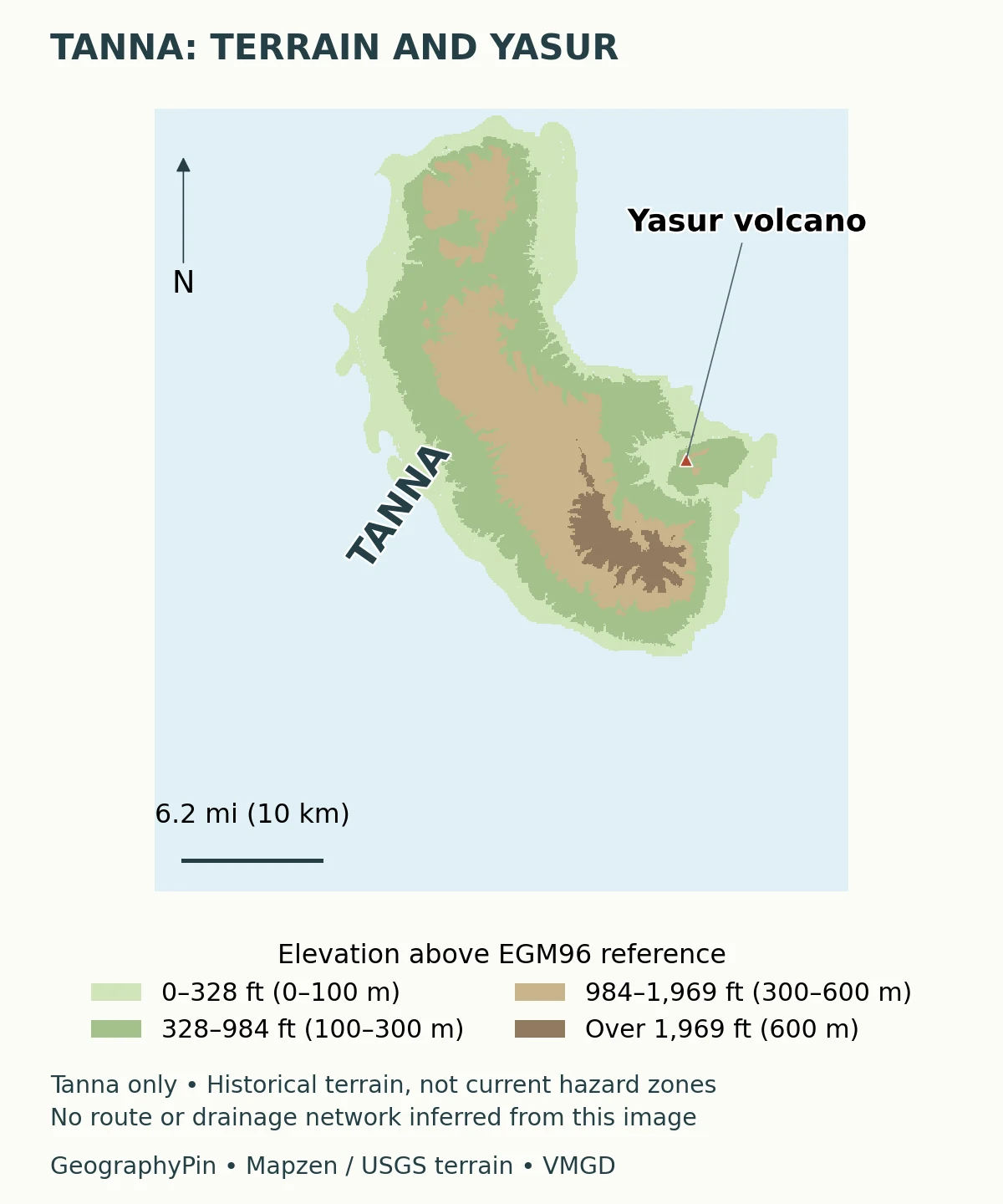
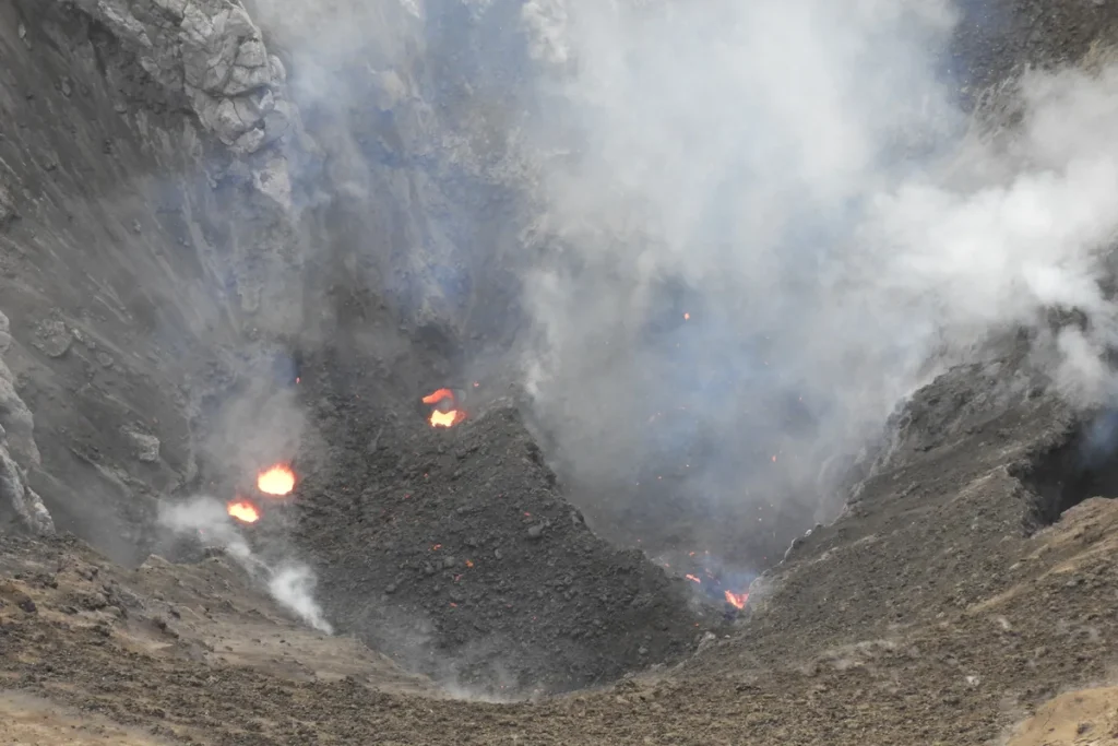
The Vanuatu Meteorology and Geo-Hazards Department describes Yasur as a scoria cone in southeastern Tanna, about 1,184 feet (361 meters) high. That height describes the volcanic feature; a digital terrain value at a point inside its crater need not equal the rim’s stated height.
The elevation map places the volcano within the island rather than treating Tanna as one enormous cone. Its colors represent historical terrain elevations, not activity levels. A dark or high area on this map does not automatically indicate greater volcanic danger, and a lower area is not automatically safe.
Yasur also illustrates the difference between a landscape photograph and a current report. The featured photograph records the north crater in September 2017. It documents a real volcanic setting, but it cannot establish today’s access rules, eruption behavior or exclusion zones. Those require the latest volcano-specific bulletin from the national monitoring authority.
5. Climate changes with season, exposure and terrain
Vanuatu generally has a warmer, wetter season from November to April and a cooler, drier season from May to October. These are broad seasonal patterns, not promises of rain-free days or uniform conditions across the archipelago.
A joint Vanuatu meteorological service, Australian Bureau of Meteorology and CSIRO climate report explains the importance of the South Pacific Convergence Zone and the surrounding ocean-atmosphere system. On larger mountainous islands, southeast-facing windward slopes can receive more rain than sheltered leeward areas. An island’s orientation and relief therefore help explain local differences that a single national weather average conceals.
Year-to-year variation matters too. El Niño conditions can bring reduced rainfall and a later wet-season onset at the stations discussed in that report. This is a relationship observed in climate records, not a forecast for an individual trip. A country profile can explain the pattern while leaving current forecasts and warnings to the meteorological service.
There is also a practical distinction between seasonal climate and an extreme event. A tropical cyclone can disrupt communities and transport severely, but cyclone exposure is not caused by the subduction zone. Atmospheric hazards and geological hazards may affect the same islands while arising from different physical processes.
6. Settlement, connections and livelihoods
The 2020 census classified about 22 percent of the population as urban. Its urban categories center on Port Vila and Luganville; most residents were counted outside those urban areas. This dated classification is more informative than assuming that the capital’s appearance represents national living conditions.
In an archipelago, distance has more than one meaning. Two settlements may look close on a map but lie on different islands. A road can connect places within an island without solving the sea crossing between them. Mountains can further complicate the relationship between straight-line distance and the route people actually use.
Port Vila and Luganville are important reference points for the settlement system, but the country also consists of dispersed communities with distinct local settings. The census’s household agriculture section shows the importance of cultivation for both home consumption and sale. These categories can overlap within one household, so rural life should not be reduced to a simple choice between “subsistence” and “commercial” farming.
Tourism draws attention to volcanic landscapes, coasts and island environments, while agriculture and other local livelihoods connect residents to land and sea. Geography helps explain why reliable connections matter to these activities: getting produce to a market and reaching an island destination both depend on more than the distance printed beside a map. Specific flight or shipping schedules can change and are not implied by the locator.
Language is another distinction worth preserving. Bislama’s status as national language does not make English and French unofficial, and the three official languages do not exhaust the languages spoken across the islands. Article 3 of the constitution also addresses the protection of local languages. National administration and local linguistic geography operate at different scales.
7. Understanding hazards geographically
Vanuatu faces volcanic activity, earthquakes, tsunamis and tropical cyclones, but these should not be collapsed into a single national danger label. A volcano’s condition is site-specific. Earthquake effects depend on the event and local ground conditions. Tsunami exposure concerns coastal settings and the source of the waves, not simply proximity to a smoking crater.
Research on the southern New Hebrides subduction zone discusses local and more distant tsunami sources. This reinforces an important reading rule: a historical event or modeled scenario is not a precise prediction of when the next event will occur. Nor does a national profile replace a local evacuation plan.
For current decisions, use VMGD’s official geohazard information and the relevant local instructions. A photograph, elevation map or evergreen article can explain the setting; it cannot authorize entry to a restricted area. The maps here intentionally show neither supposed safe zones nor unverified emergency routes.
What Did We Learn Today?
Vanuatu is best understood as a connected but varied island chain: Espiritu Santo contains its highest mountain, Efate contains the capital, and Tanna provides a clear example of active volcanism within a broader island landscape. Terrain, rainfall and sea crossings shape how places connect. Dated statistics, careful territorial wording and island-specific hazard information prevent a country map from becoming a misleading picture of uniform conditions.
Sources & Data Notes
Population figures distinguish the November 2020 census from the June 2025 estimate. Published land-area totals differ; the rounded figure is not a reconciliation of those sources. The terrain data and featured photograph describe historical conditions, not current hazard levels.
- Government of Vanuatu: national overview and Vanuatu Tourism Office: geographic overview. Used selectively for location, island arrangement and basic geographic facts; older population and tourism figures on these pages are not treated as current.
- Vanuatu Bureau of Statistics: resident estimate of 343,320 as at June 1, 2025. 2020 census, Analytical Report Volume 2, sections 2.1, 2.3, 2.5 and 5.4.11: enumeration, area, urban classification and household agriculture. Different area totals are reported transparently rather than silently reconciled.
- Constitution, Article 3: national and official languages and protection of local languages.
- Roger and Pelletier (2024), regional tectonic and tsunami context, particularly section 1.1; Roger et al. (2023), section 2: subduction and microplate setting. Neither is used as a current volcanic alert.
- VMGD: Yasur, location and landform description. Current activity levels and access restrictions are deliberately not frozen into this profile.
- Current and future climate of Vanuatu, VMGD, Australian Bureau of Meteorology and CSIRO: seasonal climate, terrain effects and ENSO. The upload directory’s year is not the date of the underlying historical observations.
- Vanuatu–France joint communiqué, July 23, 2025, and French government response, February 10, 2026: the Matthew and Hunter sovereignty dispute. The locator does not depict maritime claims or decide sovereignty.
- Original GeographyPin locator uses public-domain Natural Earth coastlines and settlement data. The Tanna map uses historical Mapzen terrain data, including USGS sources, sampled from the S20E169 elevation tile. Terrain is referenced to EGM96, not an instantaneous local sea level. It covers Tanna only and does not supply a national drainage survey.
- Featured photograph: Yasur north crater, Tanna, Marks6651, September 29, 2017, CC BY 4.0. Cropped, resized and converted to WebP for this page; no GeographyPin watermark added. The historical image is not a current hazard report.